Showing posts with label plate tectonics. Show all posts

Tuesday, March 3, 2026

Strange Volcanic Sisters on California's Central Coast

A geo gift for Christmas!
One of my relatives has an eye for fun and fitting gifts. Most recently she gave me a tote bag featuring the Nine Sisters of northern San Luis Obispo County—rocky peaks all in a line, reaching from the town of San Luis Obispo to the sea. The northwesternmost, Morro Rock, is the one everybody knows.
Morro Rock, "the most striking scenic feature on the coast of California" (Fairbanks 1904).
The other Sisters are not nearly as famous, though thousands of people race past them daily. Nor is their number agreed upon. When I was a kid on the Central California Coast long ago, there were seven. Now the more commonly used number is nine. But as geologists know, there are many of these very strange peaks—all of the same rock, all very steep, and all neatly aligned. And they wonder: How did this happen? Why are they here?
The 23 Sisters or Morros (Spanish for "hills") are also known as the Morro-Islay Volcanic Complex.
The Nine Sisters are labeled, with others in between; from northwest (top) to southeast (bottom). See full panorama by SLOhiker.
In October of 1860 William H. Brewer, a recent hire with the brand new California Geological Survey, boarded a steamer in New York City. After a week at sea, he arrived in Panama, crossed the isthmus by railroad in a day, boarded a steamer headed north, and ten days later arrived in San Francisco, where he learned of Lincoln's election. The evening was spent observing celebrations—"fireworks, processions, etc."

After supplies had been secured, Brewer and three others traveled back south by steamer to San Pedro, the port of Los Angeles. In early February, they headed north by horse and mule-drawn wagon, prepared to survey as far as Monterey.

California Geological Survey field party, 1864 (not the 1861 crew); Brewer in chair (Brewer 1930).
As they worked their way north, Brewer wrote letters describing the surrounding country and their adventures in great detail. He mailed them to his brother (where postal service was available), who had been directed to share them with family and friends, and then hold for Brewer's return. Amazingly, all but two or three letters were delivered; they were published in 1930 (source of quotes here).

In early April they entered San Luis Obispo County on terrible roads—"no road in fact, but a mere trail, like a cow path, hardly marked by the track of wheels, and often very obscure." A bad wreck in the Arroyo Grande delayed them for a day as they reassembled and reloaded the wagon. They continued on the so-called 'better' road to San Luis Obispo, arriving a few days later.

Brewer found San Luis Obispo to be "a small miserable town" in a lovely setting:

"San Luis Obispo town lies in a beautiful, green, grassy valley, about nine miles from the sea. ... This valley is more like a plain, from four to six miles wide and fifteen or twenty long, running northwest to the ocean."

They camped near a butte that was "beautifully rounded, about eight or nine hundred feet high and perfectly green."

Brewer's party likely camped near today's Cerro San Luis (Leif Arne Storset photo).
Though beautiful, the butte was quite strange in the way it rose so suddenly from the plain. And there were many such buttes, all equally odd, all curiously aligned.

"These buttes are a peculiar feature, their sharp, rugged outlines standing so clear against the sky, their sides sloping from thirty to fifty degrees! ... A string of these buttes, more than twenty in number, some almost as sharp as a steeple, extend in a line northwest to the sea, about twenty miles distant, one standing in the sea, the Morro Rock, rising like a pyramid from the waters."

"Through this plain rise many sharp peaks or 'buttes'—rocky, conical, very steep hills" (hakkun photo).
An unnamed butte, one of many (Ronn Koeppel photo).
As for their geology, Brewer noted only that the buttes were "mostly of volcanic origin, directly or indirectly". If he thought it odd to find volcanos here, he didn't say (1).

Brewer is often credited with today's name: "these buttes are in a line, nine in number, and I propose to call them the Nine Sisters." But in reading his letters I found no such statement. He never called them the Nine Sisters and counted at least twenty. Claude AI found this false quote in multiple places, "copied uncritically from source to source".

Before leaving San Luis Obispo County, Brewer and a companion climbed and measured the Santa Lucia Mountains. It was a lovely day—cool and clear—and views from the crest were worthy of contemplation.

"the breakers on the shore were perfectly distinct twenty miles distant! [italics his] To the southwest and west lay all the lovely plain of San Luis Obispo, the buttes rising through it—over twenty were visible—brown pyramids on the emerald plain. We sat and contemplated the scene for over an hour before leaving."
"brown pyramids on the emerald plain" (Basar photo).
About forty years later, Harold W. Fairbanks of the US Geological Survey surveyed, mapped and described the geology of the San Luis Quadrangle (west-central San Luis Obispo County). He too was struck by the curious line of rocky peaks and ridges, which he called the "San Luis buttes".

"South of the town of San Luis Obispo there begins a line of peaks and ridges which extends northwestward for about 16 miles. It terminates in Morro Rock, lying in the ocean off Morro Bay. This series of buttes constitutes the most striking topographic feature of the quadrangle. There are about 12 ... Many of them are almost completely isolated and rise from the open valleys with bold and frequently precipitous rock faces." (Fairbanks 1904, source of quotes here).

San Luis Obispo c. 1903, with two of the San Luis buttes behind.
"Hollister Peak rises from a base but little above tidewater to a height of over 1400 feet" (Ronn Koeppel photo).
Fairbanks knew the San Luis buttes were volcanic, the rocks made that clear. He identified dacite and andesite in roughly equal abundance; dacite is now considered the dominant type.

Dacite contains visible crystals set in a fine-grained gray groundmass—classic porphyritic texture. This led Fairbanks to call the rock dacite-granophyre ("phyre" from porphyry), a term no longer in standard use. But he was correct about the porphyritic texture, and that led him to another conclusion, also correct. The San Luis buttes are volcanic plugs formed at shallow depths, not extruded magma. They were exposed later when erosion removed the softer surrounding rocks.

Dacite: plagioclase feldspar (large whitish crystals), biotite and quartz in a gray groundmass (Johnston 2021).
In the Geologic History section of his report, Fairbanks tried to place the volcanos in the greater scheme of things, but their age "could not be definitely ascertained from any observations made." It appeared that their intrusion had not deformed adjacent Cretaceous rock, and therefore the volcanos must be older. He assigned them to the early Cretaceous Period, between 140 and 100 million years ago (2). We now know they are much younger, emplaced 27 million years ago (Beck & Johnston 2011).

Like Brewer before him, Fairbanks did not try to explain why these volcanos had erupted here. It was an understandable omission. Geology was still a young science; sixty years would pass before geologists came up with widely-accepted explanations for volcanism.

Excerpt from Fairbanks's geologic map; San Luis buttes are the orange blobs from upper left (Morro Rock) to lower right (Islay Hill). Click on image to view.
The great progress geologists have made in deciphering the hows and whys of landscapes is due largely to the theory of plate tectonics. In brief, the Earth's surface consists of giant plates—on the order of a dozen large ones and many smaller. Though massive, they are not stationary. They shift, jostle, collide, rise and sink, expand and contract, and deform each other in various ways. Their movement is much too slow for us to sense, just 2 to 10 cm per year, like the growth of a fingernail. In contrast, the results are spectacular—for example mountain ranges, ocean basins, earthquakes and volcanos.

But in spite of our understanding of plate tectonics, the volcanic buttes between San Luis Obispo and the sea remain puzzling. The problem is their location. Volcanos can't erupt just anywhere; there must be a source of magma. But magma doesn't occur just anywhere. It forms with melting of the mantle, the immense mass of solid but soft rock that lies well below the Earth's surface.
Earth's internal structure (IsadoraofIbiza). The voluminous mantle is the source of volcanic magma, but only under the right conditions.
Though the mantle underlies all of Earth's crust and forms 84% of its volume, it only melts sufficiently for volcanism in special situations. The common ones are: (1) mid-ocean ridges, where two plates are moving away from each other; (2) hotspots perhaps created by rising plumes of anomalously hot mantle (they're controversial); and (3) subduction zones where one tectonic plate dives under another deeply enough to melt (Nelson 2015). The Sisters fit none of these scenarios.
California's Central Coast 40 million years ago, expected areas of volcanism circled in white. But the Sisters erupted into a thick stack of sedimentary and metamorphic rocks (from Johnston 2021; annotations mine).
The Morro-Islay volcanos all erupted into a thick stack of sedimentary rocks (3), well away from the usual tectonic settings. And the amount of magma was far too little to have been produced by a hot spot (think about all the volcanic rock in the Hawaiian islands!). So why did these volcanos erupt here? Because 27 million years ago there was a window of opportunity—specifically a slab window.

If we were to visit the coast of North America 27 million years ago and look west, we would see ocean to the horizon. But something very interesting was going on below the surface. Not far away, the seafloor was spreading along a mid-ocean ridge, with mantle rock welling up and melting, and volcanos erupting (yes, underwater!).
Mid-ocean ridge in action; orange upwelling is melted mantle (USGS).
That mid-ocean ridge was the boundary between two tectonic plates—the Pacific to the west and the Farallon to the east. The entire system was moving eastward, forcing the Farallon Plate to dive under the North American plate. This was a straightforward example of subduction until the mid-ocean ridge arrived. When it reached the subduction zone, the Farallon Plate continued sinking eastward while the Pacific Plate moved northwest. No longer connected, they opened a slab window where mantle could rise, melt, and produce the magma that formed the Sisters.

And there would be more drama—not just volcanos but also earthquakes. With the Farallon Plate gone, the Pacific Plate continued moving northwest, but now along the coast of North America. Subduction was replaced with a transform fault moving in slips and jerks, periodically wreaking havoc (earthquakes). This slab window turned out to be a major tectonic event—giving birth to the San Andreas fault as well as the Sisters!
Creation of the San Andreas transform fault (parallel but opposite arrows) with the arrival of a mid-ocean ridge (dark pink band) (USGS, highly modified).

To end this story, let's return to its beginning—to Morro Rock and the words of William H. Fairbanks. In Economic Geology, the final section of his report, he wrote:
"The buttes extending from San Luis Obispo northwestward to Morro Rock furnish excellent and durable stone for building purposes. A quarry has been opened on Morro Rock for the purpose of supplying material for the Port Harford breakwater, and blocks of any size can be obtained. It is to be hoped, however, that the grandeur and symmetrical proportions of this mass will not be marred, as equally good material can be obtained from the other buttes."

Morro Rock was quarried off and on from 1889 to 1963. It now belongs to the State of California, and has been designated both a state and historical landmark (more here). And fortunately, its "grandeur and symmetrical proportions " are still with us.


Notes

(1) Brewer's very brief discussion of the origins of the buttes isn't surprising. He was a surveyor, not a geologist. In fact his title was Principal Assistant in charge of Botanical Department. But he was an astute observer, shown by his tally of the buttes for example.

(2) Fairbanks was not convinced that the San Luis buttes were Cretaceous in age. In his Geologic History section he noted "There were at least two epochs of igneous activity during the Cretaceous, and three if the formation of the San Luis buttes be included."

(3) The sedimentary rocks intruded by the Morro-Islay volcanos are part of the Franciscan Complex— a diverse assemblage of sedimentary and metamorphosed rocks accreted to the North American plate during subduction—an accretionary wedge.

Sources

Beck, MD, Johnston, SM. 2011. U-Pb geochronology and geochemistry of the Morro-Islay volcanic complex, southern California. Abstract.

Brewer, WH. 1930. Up and down California in 1860–1864 (introduction by Francis P. Farquhar). Oxford University Press. Available at Hathitrust.

Fairbanks, HW. 1904. Description of the San Luis Obispo Quadrangle, California: Geologic Atlas. San Luis Folio 101, USGS. 7 PDFs

Johnston, SM. 2021. The Morro-Islay Volcanic Chain and what's a slab window anyway? Video lecture. Highly recommended.

Morro Bay National Estuary Program. 2024. A Geologic History of Morro Rock (includes the geology of the Sisters, with simple diagrams).

Nelson, SA. 2015. Structure of the earth and origins of magma. Lecture outlines; very clear!

Sierra Club, Santa Lucia Chapter. The Nine Sisters of San Luis Obispo County. Web Archive.

Wikipedia's Morro Rock article includes the geology of the entire Morro Rock-Islay Hill Complex.

Monday, December 8, 2025

Geohopping across Nevada

Burners at incipient plate boundary in western Nevada. Are they waving California goodbye? (original unknown)
Many times I've crossed Nevada in the company of Frank DeCourten and Norma Biggar (hereafter called D & B). Actually I've never met either one, but I know their Roadside Geology of Nevada well. That's where I learned of the state's traumatic history—torn apart, reassembled, buried in ash and welded rock, and now being torn apart again. These stories can be hard to grasp, but I've read and reread the lengthy introduction enough to be awestruck by landscapes that many travelers find dull.

Sturdily bound, with high quality paper—my copy has survived lots of use.

Maps, diagrams and photos are abundant!
In the eight years since D & B published their book, I've often parked off the highway at their suggestion to study and photograph a geologic feature. I think of this as geohopping to geostops, rather than my usual geotripping to geosights (and later blogging about it). Now it's time to give the geostops their due.

One of my favorite stretches of highway between Laramie, Wyoming (home) and the California Central Coast (home of relatives) is US 6 across Nevada. Traffic is light, towns are few, and the geology truly is dramatic!

Geo highlights along US Highway 6, May 2025.
For example, about thirty million years ago, widespread cataclysmic destruction associated with the Great Ignimbrite Flareup (GIF) created Hell right here on Earth. Supervolcanoes erupted repeatedly across today's Nevada depositing ash thousands of feet deep, much of it welded into rock by the searing heat ("ignimbrite" means "fire cloud rock"). Trying to recreate that terrifying Flareup in my mind is one of the joys of driving across Nevada.

But it's impossible to properly imagine the GIF, in part because "no volcanic eruptions ever witnessed by humans come close to rivaling these prehistoric paroxysms." And the geologic record suggests it may be one of the largest ever. Consider this: in Nevada at least 230 supervolcanoes ejected an estimated 17,000 cubic miles of lava! Here's another way to think about it: at least 30 of these eruptions each equaled 600 Mt. St. Helens eruptions!

Blue Jay Maintenance Station on left, remnants of cataclysmic destruction behind.
About 90 miles southwest of Ely, I stopped at Palisade Mesa in the southern Pancake Range. Parking is available at a small rest area next to the Blue Jay Maintenance Station. Volcanic rocks of the GIF are nicely exposed on the steep slope to the east.
Rock pancakes stacked oldest to youngest, from bottom to top.
Palisade Mesa is one of multiple gently-tilted stacks of volcanic rock that give the Pancake Range its name. The escarpment at Blue Jay shows at least four episodes of eruption, all from the immense Central Nevada caldera complex. The pale bottom (oldest) layer is a lightly-welded tuff from an ash flow c. 31 million years ago. Next is a thin black band of glassy vitrophyre—"a flow of glowing ash that became densely welded."
Vitrophyre—beautiful memento of incandescent destruction. James St. John.
The massive brown layer above the vitrophyre is a younger tuff, about 30 million years old. Being a fan of columnar jointing, it was my favorite. The summit is a 2.75 million-year-old tuff that's sufficiently welded to provide an erosion-resistant cap.
I 💖 columnar jointing—created by contraction with cooling.
The view south beckoned.
Palisade Mesa obviously deserved a longer visit, perhaps a hike along the base and up the valley to the south. But not this time. Instead I continued west.

Those who cross the middle of Nevada (e.g. east to west) soon become aware of its extensive deformation even if they have no idea what happened. For example: When I left the Pancake Range I crossed Hot Creek Valley, then the Hot Creek Range, then Stone Cabin Valley, then the Monitor Range, and then Ralston Valley before stopping in Tonopah near the crest of the San Antonio Mountains. This is typical Nevada topography—valleys and mountain ranges one after another, all trending roughly north–south. The great pioneering geologist Clarence Dutton called them “an army of caterpillars marching north from Mexico".
Left of center, caterpillars are marching across the Basin and Range Province (NPS).
The cause of this curious pattern is east-west continental stretching, which started something like 18 million years ago and continues today. Some parts of Nevada and adjacent Utah and California have nearly doubled in width! In the process normal faulting has dropped basins, leaving adjacent land standing high, as mountain ranges.

In Tonopah, I stopped for gas and groceries as I often do. Here Hwy 6 merges with heavily-traveled Hwy 95, but at Coaldale Junction they diverge, and once again I had the highway mostly to myself. This is where I stumbled upon Radio Goldfield several years ago, broadcasting very local news and interesting country-ish, old-timey, new-to-me music. It's still going strong.
At the advice of D & B, I kept an eye out for a diatomite quarry on the left, near the junction with NV Hwy 264. The white patches were obvious. This diatomite is thought to be the same age as late eruptions of the GIF, but the setting was entirely different—a shallow freshwater lake where diatoms (microalgae) basked in the sun. Now they're diatomaceous earth, a soft crumbly rock that's 80–90% silica. Among its many uses are metal polish, toothpaste, cat litter, dynamite, thermal insulation, and bonsai soil amendments.
I would have enjoyed examining the diatomaceous earth, but wasn't clear on ownership.
Diatomaceous earth up close; scanning electron micrograph by Dawid Siodłak.
After continuing west across Montgomery Pass, I dropped into Queen Valley for the final geostop of the day, parking in a large pullout not far from California. Across the valley was the north end of the White Mountains; the snowy Sierra Nevada was visible in the far distance. It was a lovely peaceful place, or so it seemed that day. But nearby were clear signs of geologic trauma.
White Mountains rise steeply above floor of Queen Valley.
Normal faulting evidenced by triangular facets (arrows).
Across the valley at the base of the White Mountains is a normal fault just 3 million years old. This is the Queen Valley fault—a tiny piece of the immense Walker Lane. I had entered a profound but vague tectonic boundary, where the Basin and Range Province meets the great Sierra Nevada.
At Walker Lane (yellow), very different tectonic regions meet. SAFZ is San Andreas Fault Zone, a critical part of this story (Carlson et al. 2013).
Walker Lane is young—just 10 million years old at the south end, and only a few million at the north. The combination of Basin and Range extension and transverse movement of the Sierra Nevada has created a complex zone of faults that's poorly understood. Even so, Walker Lane generates a great deal of excitement among geologists. Perhaps a new plate boundary is forming! Maybe California will drift away!

Like the better known San Andreas Fault to the west, Walker Lane is contributing to the slow, incessant, contrary motions of the Pacific and North American tectonic plates, which are pulling a large part of California northward. Currently the San Andreas is responsible for about 80% of this movement but Walker Lane appears to be catching up.

Fauds & Henry (2008) predict that in another 7 to 8 million years or so, the northern part of the San Andreas will join Walker Lane, extending the Gulf of California north by hundreds of miles and turning California into a peninsula along a new plate boundary. 

If this tectonic shifting continues, as the authors think it will, California will become the island that was regularly reported by explorers hundreds of years ago! This was the "famous cartographic error that appeared on many European maps from the 16th to the 18th centuries" (David Rumsey Map Collection).
"Novissima et accuratissima totius Ameriae" by Nicolaes Visscher, 1690. Large island off the west coast of North America is California. DRMC
Peering even further into the future, we may well find that California Island has become an exotic terrane (quit snickering!). As such, it could travel far and wide before being stopped at some convergent plate boundary, thousands of miles from its origin at Walker Lane.

But Emmie ... our ephemeral lives mislead us. The Earth is far from stable.

Sources

agimark 2018. Splitting North America – The Walker Lane; Part 1 – The Tectonics; Volcano Hotspot blog. Accessed Dec 2025.

Carlson, CW, et al. 2013. Kinematics of the west-central Walker Lane ...  Geosphere 9: 1530–1551.

David Rumsey Map Collection, an unbelievably wonderful resource for fans of old maps. WARNING: it's very easy to spend a lot of time here. https://www.davidrumsey.com/

DeCourten, F, and Biggar, N. 2017. Roadside Geology of Nevada. Mountain Press.

Faulds, JE, and Henry, CD. 2008. Tectonic influences on the spatial and temporal evolution of the Walker Lane: An incipient transform fault along the evolving Pacific – North American plate boundary. Nevada Bureau of Mines and Geology, Arizona Geological Society Digest 22. The future of California is discussed on page 463. PDF

Wolterbeek, M. 2020 (Feb 18). How the burgeoning Walker Lane may split the American West; in Nevada Today, UNV Reno.

Monday, September 27, 2021

Reassembling Western Nevada

Lone Mountain, a thick stack of Lower Paleozoic sediments deposited on the continental shelf of Laurentia. North of US Hwy 50, c. 15 mi west of Eureka.

This post is the sequel to Where on Earth did western Nevada go? ("Nevada" as defined by political boundaries). In the Proterozoic, roughly 700–600 million years ago, a continental rift sent the west half of Nevada drifting away, replaced by a widening sea. The east half stayed behind as part of Laurentia—predecessor to North America.

Now that coastline is a distant memory, for western Nevada has been reassembled. The missing Precambrian rocks were replaced with a patchwork of shoved-up seafloor, wandering fragments of lithosphere, deformed volcanic islands, widespread igneous intrusions, and more.
Domains, terranes, and assemblages of Nevada (Crafford 2010). Added dashed line is a rough approximation of the late Proterozoic rift.
Passive margin, long-lived but not forever

Reassembly didn't start right away. For several hundred million years, the Laurentian coast was a passive margin—the continent and seafloor on the same plate, with no tectonic activity. Thick layers of sediments accumulated offshore. Three zones of deposition are recognized, now represented by early Paleozoic rocks: continental shelf in eastern and central Nevada (e.g., Lone Mountain in photo above); continental slope in central Nevada; and, to the west, deep basin sediments underlain by seafloor.
Simple schematic of the early Paleozoic margin of Laurentia (trilobites not to scale ;)
By late Devonian time, the Laurentian coast no longer was passive. Plate reconstructionists have concluded that while the east coast of Laurentia was colliding with continental masses from the east, the west coast was overriding the adjacent oceanic plate. The result was mountain-building. Seafloor and deep basin sedimentary rocks were shoved east to become high, dry, and out of sequence in central and eastern Nevada.

The first such event was the Antler Orogeny, now thought to have lasted long enough to have involved collisions with multiple island arcs and/or continental fragments. Deformed deep basin sediments were thrust east over the continental shelf (Roberts Mountain thrust; yellow unit in map above). This was followed by the Sonoma Orogeny, when the Sonomia superterrane collided during Permo-Triassic time, sending deformed deep basin rocks and seafloor eastward (Golconda thrust; dark blue unit in map above).

Continental expansion really took off during the Mesozoic, with the arrival and accretion of numerous terranes—island arcs and other chunks of lithosphere. By the beginning of the Cenozoic era, western Nevada had been reassembled. It was all land, with no ocean in sight.

Mapping Nevada's terranes

Given all that has happen in Nevada during the last several billion years, geologists have found it useful to divide the state into tectonic domains, a domain being an area of rocks with a distinct tectonic history (Crafford 2008). For example, there are three domains from the time of the Paleozoic passive margin—Shelf, Slope, and Basin. The Antler and Golconda domains are the major Paleozoic thrusts described above.

In contrast, the terranes that drifted in and accreted to Nevada during the Mesozoic are difficult to figure out and map. These are defined as areas bounded by faults, each with its own usually-perplexing geologic history. "While significant progress has been made in identifying distinct terranes ... when these terranes arrived, and the nature of their total displacement relative to each other and the autochthonous part of the Mesozoic margin is variably constrained" (Crafford 2008). In other words, where they came from, how they got to where they are now, and why they are so deformed will provide research topics for many years to come.
Mesozoic terranes and assemblages of Nevada (Crafford 2010).
Puzzles that they are, the Mesozoic terranes have been assigned to just two domains. The first contains the Jackson–Blackrock composite terrane in northwest NV. The second contains everything else. Called the Mesozoic terranes and assemblages domain, it includes "most of the pre-Tertiary rocks exposed in the western third of northern Nevada" (Crafford 2008).

There but for the grace of the Guide go I

I was in the western third of northern Nevada last May, and was able to visit several of these mysterious chunks of lithosphere, thanks to Roadside Geology of Nevada by Frank DeCourten and Norma Biggar (2017). I'm quite sure I would not have spotted them on my own. 

The first was the Pine Nut assemblage in far west Nevada. Not far from California, NV Hwy 338 passes right through a narrow gap between outcrops (did highway surveyors have geologists in mind?). Once a terrane, the Pine Nut is now considered one of three assemblages of the Walker Lake terrane (Crafford 2007). Decourten and Biggar, with apt prudence, describe this particular outcrop as metavolcanic—probably an island arc that collided with western Nevada sometime in the Mesozoic.
Two puzzling mementos. Metavolvanic? From whence? Deformed before or during collision?
East of Fallon, I met another ancient traveler, the Sand Springs terrane. Here it's composed of platy black rocks that shine in the sun—Triassic deep sea deposits metamorphosed to phyllite and slate (DeCourten and Biggar). Elsewhere, Sand Springs rocks are volcanogenic (Crafford 2007).
North of US Hwy 50 just west of Sand Springs Pass; rhyolite intruded into slate and phyllite.
My camera struggled with the dark but shiny phyllite and slate.
Like the Pine Nut, this Sand Springs outcrop wouldn't strike me as out-of-place if I hadn't read that it is. Knowledge is so wonderful! In fact, it's one of the great benefits of being human. Standing on a hot dry roadside, we can imagine ourselves on a beach with volcanic islands just offshore. Or perhaps on trembling ground as yet as another accretionary terrane collides with Nevada.
My field assistant is not a fan of roadside outcrops (she has to stay in the van).

Sources

Crafford, AE. 2007. Geologic map of Nevada: USGS Data Series 249.

Crafford, AE. 2008. Paleozoic tectonic domains of Nevada: An interpretive discussion to accompany the geologic map of Nevada. Geosphere 4:260-291.

Crafford, AE. 2010. Geologic terrane map of Nevada. NV Bureau Mines & Geol. Open-File Rep 2010-04.

DeCourten, F, and Biggar, N. 2017. Roadside Geology of Nevada. Mountain Press [summarized in Geology of Nevada].

Tuesday, September 7, 2021

Where on Earth did western Nevada go?

Does the Siberian craton include part of Nevada? (source; text added).
Nevada geologists claim that their state is diverse. I think they're right. On my recent geotrip across the central part, I saw rocks and features dating from Paleozoic time to recent, from the 370-million year old limestone of Devils Gate to a 57-year old fault scarp. However, I saw nothing Precambrian. That's not because Nevada didn't exist then; it did. But now half of Proterozoic Nevada is buried, and the other half is ... GONE!

There are geologists who specialize in running plate tectonics backwards. Using a variety of evidence, they trace the paths of Earth's lithospheric plates to deduce earlier arrangements of continents. They've had some success. For example, there is general agreement that multiple smaller continents (like today) have alternated with a single or several supercontinents. But exactly how continents collided to become a supercontinent, and then how the supercontinent broke up and where the pieces went, are puzzles not easily solved.

A rift runs through it

In the late Proterozoic, roughly a billion to 700 million years ago, Earth's land masses were aggregated into a supercontinent named Rodinia (Russian for "homeland"). Then it broke up into multiple continents and terranes (smaller fragments). The ones that concern us here are Laurentia (predecessor of North America), Siberia (a separate continent then), and Eastern Antarctica.
A reconstruction of Rodinia about 900 million years ago (source); text added.
During Rodinia's breakup, a rift developed across what is now Nevada, from roughly northeast to southwest (modern day compass directions). Eastern Nevada remained part of Laurentia while western Nevada drifted away; they were separated by a widening sea.

Fortunately (for those of us who love such things), the Laurentian coastline is still with us, now called the "0.706 line". It was detected by analyzing many granitic igneous intrusions emplaced long after rifting. The rising magma passed through rocks dating from the time of Rodinia's breakup, and in the process, material from those rocks was assimilated, including two strontium isotopes—87Sr and 86Sr. This is helpful! In continental rocks, the ratio of the two isotopes is greater than 0.706; in seafloor rocks, it is less. So strontium ratios reveal where the late Proterozoic continent and seafloor met.
The 0.706 line (after Kistler & Ross 1990).

Whither western Nevada?

Returning to the original question, where did the continental fragment west of the rift go? Since it was once continuous with eastern Nevada, surely it remains similar in some way—perhaps sharing the same rocks or geological structures. So have geologists wandered the world searching for a similar chunk of continent? Of course they have!

A leading contender resides in the Siberian craton in northeast Asia. The evidence is persuasive. The Sette Daban area of Siberia and the Death Valley area in southwest Nevada share "remarkably similar" sequences of Precambrian sedimentary rocks. In both locations, these "consist of five or six variegated siliciclastic-dolomite cycles that are each made up of numerous smaller cycles ..." (MacLean 2009). Similarity at such a fine scale is compelling.

Furthermore, fossils of the two areas are similar. Especially notable are the trilobites, which usually are limited in distribution. Shared types suggest the two areas were in close proximity. Geologic features are shared as well. Dike swarms and orogenic belts align nicely when the northeast margin of the Siberian craton is placed adjacent to western Laurentia (Sears & Price 1978).
Proposed reconstruction of Rodinia ~ 1 billion years ago (Sears & Price 2003). Shared orogenic belts underlined in red ("NV?" also added).
However, other work suggests that before drifting off, Siberia was joined to Laurentia far north of today's Nevada. For example, McClean et al. (2009) showed that Large Igneous Provinces in northern Laurentia and Siberia are of similar age and chemical composition ... also persuasive evidence!

But of course if we rule out Siberia, we must return to our original question. Where is Proterozoic western Nevada—where did that rifted fragment go?!

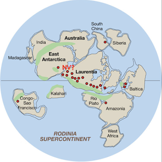
Maybe Antarctica?

Goodge et al. (2008) think they've found it in East Antarctica, which is composed largely of Precambrian craton fragments, including rocks not unlike those buried in eastern Nevada. They also cite a boulder (found in a moraine) of a somewhat unusual granite—Type A or rapakivi. It is similar to a zone of rapakivi granites that crosses North America/Laurentia, dated at ~1.4 billion years.
Rodinia 750 million years ago; red dots are ~1.4 Ga rapakivi granites (Goodge et al. 2008) ("NV?" added).
But more work is needed. Most bedrock of Eastern Antarctica is covered in ice year round. It's difficult to get a comprehensive picture from corings and rocks in moraines.

Next question

While the plate reconstructionists haven't yet answered our question as to whither, we do know that Proterozoic western Nevada is gone. Furthermore, the growing ocean that separated it from Laurentia has disappeared too. So what makes up western Nevada now? Stay tuned.
Pine Nut metavolcanics in western Nevada—a traveler come to rest.

Sources

DeCourten, F. 2003. The Broken Land; adventures in Great Basin geology.

DeCourten, F and Biggar, N. 2017. Roadside Geology of Nevada.

Goodge, JW, et al. 2008. A positive test of East Antarctica-Laurentia juxtaposition within the Rodinia supercontinent. Science 321, 235–240.

Kistler, RW, and Ross, DC. 1990. A strontium isotopic study of plutons and associated rocks of the southern Sierra Nevada vicinity. USGS Bull. 1920.

MacLean, JS, et al. 2009. Detrital zircon geochronologic tests of the SE Siberia-SW Laurentia paleocontinental connection, Stephan Mueller Spec. Publ. Ser., 4, 111–116, https://doi.org/10.5194/smsps-4-111-2009 

Piper, JD. 2011. SWEAT and the end of SWEAT: the Laurentia–Siberia configuration during Meso-Neoproterozoic times. Int. Geol. Review 53.

Sears, JW, and Price, RA. 1978. The Siberian connection: A case for the Precambrian separation of the North American and Siberian cratons: Geology 6: 267–270.

Sears, JW, and Price, RA. 2000. New look at the Siberian connection: No SWEAT. Geology 28.

Sears, JW, and Price, RA. 2003. Tightening the Siberian connection to western Laurentia, Geol. Soc. Am. Bull. 115.