Sunday, June 30, 2019

Two of Mrs. Thompson’s Novelties, & other desert wildflowers

During the winter and spring of 1872, John Wesley Powell’s second expedition down the Colorado River took a six-month break, making camp near Kanab, Utah. In early December they were joined by Ellen Powell Thompson, and her “most intelligent dog” Fuzz. Nellie was Powell’s sister and the wife of expedition topographer Almon Harris Thompson. She also was a botanist. 
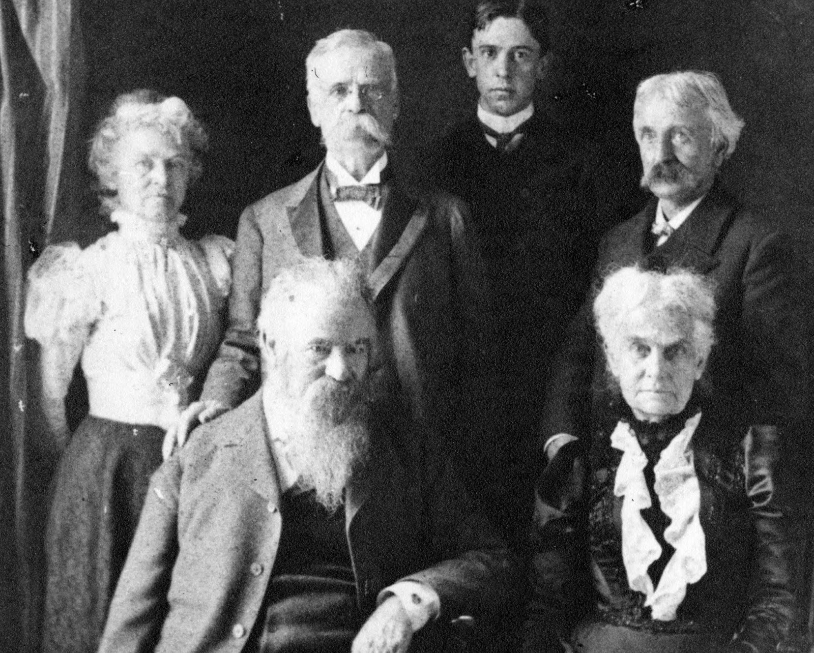
Powell family: Standing, left to right: Ellen Powell Thompson, William Bramwell Powell, William P. Powell, Almon Harris Thompson. Seated: John Wesley Powell and Mary Powell Wheeler. Topeka, Kansas, circa 1900 (source).
Their “break” was hardly a vacation. They surveyed, mapped and described the area around Kanab, and made a five-week exploratory and mapping trip, by horseback, as far west as St. George. Nellie collected plants when conditions allowed—when they weren’t wallowing through snow searching for a trail, or lying in camp sick from bad water. (See Smith 1994, and Botanist Ellen Powell Thompson for more about her adventures.)

Thompson collected, pressed and dried some 380 specimens—not a large number but respectable given the conditions. Most amazingly, at least 15 turned out to be the “novelties” so coveted by botanical explorers—species new to science (Welsh 1982).

This past May, I too explored the country and flora around Kanab, in the Grand Staircase-Escalante National Monument. The trip was a Plan B … after Plan A, a tour of central Nevada, was cut short by an extended forecast of rain and snow. The Grand Staircase area also was unseasonably cool and wet, but there was a benefit—terrific wildflowers!
 Above and below—super bloom on the Tropic shale (see previous post).
I hadn’t prepared much for Plan B. I hoped to see some of Thompson’s discoveries, but didn’t bring location data (available for more recent collections). Fortunately, I did have Spring Wildflowers of Utah’s Red Rock Desert (Lesica and Fertig 2017), an excellent guidebook for the Grand Staircase area. And I had a list of the “novelties” that Thompson collected, available in the Ellen Powell Thompson Wikipedia article. As a result, I found two of her novelties—not a lot, but still exciting!

While I was exploring the area, I often thought of Ellen Powell Thompson. Did she pass this way? She made only brief notes, so we don’t know exactly where she collected. Yet there were times when her spirit was clearly present. It was most obvious when I found Thompson’s Peteria, or the Spine-noded Milkvetch (Peteria thompsoniae).
This is the plant I had most hoped to see. It’s named for Thompson, and is easy to recognize. The pair of spines at the base of each leaf (technically spiny stipules) are distinctive, and apparently enough to warrant a separate genus, Peteria (most milkvetches are in Astragalus).
Note paired spines on stem (leaf attached on the other side, out of view).
Thompson's Peteria is the large sprawling plant in the foreground.
Nearby was another Thompson novelty—the Golden Mariposa Lily, Calochortus aureus. It’s also easy to recognize. There are no other bright yellow mariposa lilies in the area.

Next is a selection of the many neighboring blooms. First, Dorr's sage, Salvia dorrii
The flowers of Utah beardtongue, Penstemon utahensis, were a gorgeous red! Red is not something I'm used to in penstemons.
 
This cute little yellow composite is the Border Goldthread (Thelesperma subnudum).
 
This next plant had me puzzled at first. It's a 4 o'clock, specifically the Winged 4-o'clock, Mirabilis alipes. 
It was hard to overlook the Thick-stemmed Wild Cabbage, Caulanthus crassicarpus. It's an odd thing, tall and gangly. I didn't get a decent photo of the whole plant (the one below is from USDA Plants). 
Here's the thick stem.
Curious little flowers.
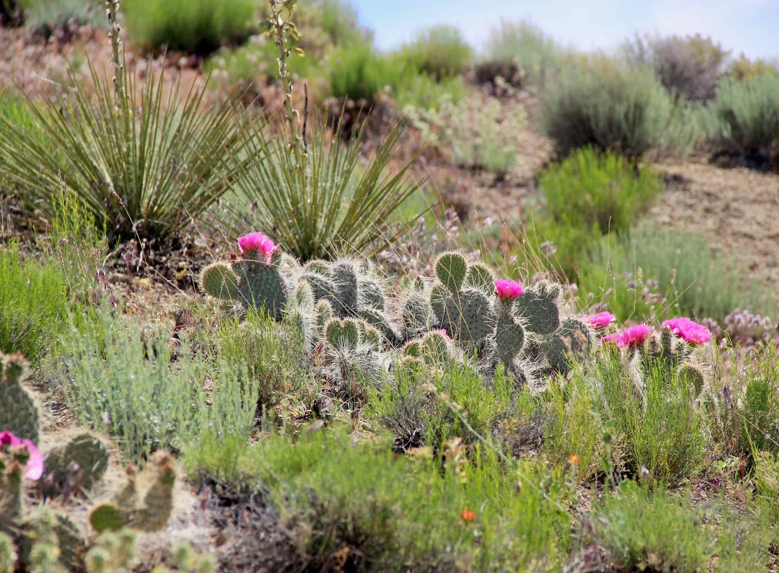
And last but hardly least, prickly pears, Opuntia polyacantha. The rose-colored form was common, and beautiful in the sunshine.

Sources

Lesica, P, and Fertig, W. 2017. Spring wildflowers of Utah’s Red Rock Desert. Missoula: Mountain Press.

Smith, Beatrice Scheer. 1994. The 1872 diary and plant collections of Ellen Powell Thompson. Utah Historical Quarterly 62:104-131. http://utahhistory.sdlhost.com/#/item/000000031001001/view

Welsh, SL. 1982. Utah plant types—historical perspective 1840 to 1981—annotated list, and bibliography. Great Basin Naturalist 42:129-189. Available at the Biodiversity Heritage Library.

Friday, June 21, 2019

Super Bloom on Tropic Shale

Looking up the Grand Staircase from the Kaibab Plateau (photo by Patti Weeks; source).
Like any staircase, the Grand Staircase of Grand Staircase-Escalante National Monument in south central Utah is composed of risers and treads. The risers are sandstone cliffs of various colors—chocolate, vermilion, white, gray and pink—that ascend from the Grand Canyon north to Bryce Canyon. Between the risers are the treads—flat to sloping terrain developed on softer more easily-eroded rocks. Though the treads don’t get nearly as much attention as the spectacular long cliff bands, they're interesting too, especially this year.
A layer cake of sedimentary rocks underlies the Grand Staircase. Modified from Doelling et al. 2000.
The tread of interest is the Tropic Shale.
Above the Gray Cliffs (Dakota sandstone) and below an unnamed riser made from the Straight Cliffs Formation, is a tread made of the Tropic Shale. This shale started as fine sediments on the bottom of the Western Interior Seaway, which covered much of central North America roughly 90 million years ago (late Cretaceous time). “Tropic” has nothing to do with the environment of deposition, instead referring to the town of Tropic, Utah, just west of the National Monument, where there are excellent exposures of the shale. This has confused some rather prominent botanists, including those working with the Federal Interagency Taxonomic Information System (more below).

Being relatively soft, the Tropic Shale erodes to form slopes and flats below sandstone cliffs of the Straight Cliffs Formation. The soil that develops is fine-textured, like the ocean-floor sediments it once was. It’s inhospitable to plants because of the way those fine particles interact with water (1). Normally, the little rain that falls isn’t absorbed into the soil, and runs off instead. But in wet years, enough soaks in for plants to grow. If it’s really wet, like this year, they go gangbusters!
The Tropic Shale and Straight Cliffs Formation are easy to spot along the Cottonwood Canyons Road, a popular geology tour (when dry). The photo above was taken near the junction with road 431, just a mile and a half north of Highway 89. The bluish-gray flats and low slopes, and the darker slopes above, are made from the Tropic Shale. The cliffs at the top are sandstone—part of the Straight Cliffs Formation, which was deposited after the Tropic Shale in a delta west of the retreating Western Interior Seaway.
But what about those large yellow patches on the flats? I was pretty sure I knew what they were, as I had recently read about shale barrens in Spring Wildflowers of Utah’s Red Rock Desert (Lesica and Fertig 2017):
“Shale barrens occur on slopes and alluvial plains where dense, shale-derived clay is at the surface. There is little or no organic matter in the soil, and water runs off rather than percolating downward. … There is little or no vegetation in most years, but spectacular blooms of annuals … may occur following a wet winter.”
This winter was indeed wet, as was spring. “Must be flowers!” I thought, and started walking.
Getting closer …
I was right. In fact, it was a super bloom! Among the hordes, I saw only two species: Colorado Plateau Stinkweed (Cleomella palmeriana) and Tropic Goldeneye (Heliomeris soliceps, formerly Viguiera soliceps). Both were easily identified with the Spring Wildflowers guidebook (highly recommended, see Sources below).
A shale barren super bloom.
Colorado Plateau Stinkweed (above and below) is endemic to the Colorado Plateau. According to Flora of North America, it grows on “dry open alkaline, gravelly or sandy flats.” Lesica and Fertig report it from “barren, clay or silty soils in salt desert shrub and clay barren habitats.” They note that it “can turn gray clay barrens yellow for a few weeks following a wet winter, but then will be essentially absent in dry years.”
Tropic Goldeneye (below) is even more limited in distribution. Flora of North America reports that it grows on gumbo clay knolls and bluffs in Utah, and is of conservation concern. The common name is said to be Tropical Goldeneye, but we enlightened geo-types are sure this must be incorrect! Surely it is named for the Tropic Shale—and Lesica and Fertig confirm that this is the case. The Tropic Goldeneye grows on “barren, clay soil derived from the Tropic Shale in salt desert shrub communities. Known only from south-central Utah. … it is abundant where it does occur in years with good winter rainfall.”
 

Some readers, having been hooked by the title, may be disappointed by my super bloom. After all, the flowers are all the same color, and aren't continuous. Just look at all that bare ground! But it was indeed super—super wonderful to be in a wild landscape with thousands of blooming plants that most years are just seeds lying in the dust of a shale barren, waiting for a deluge.
No selfies from this super bloom, just a shot of my field assistant (center left; click image to view).

Note

(1) Fine-textured soils are often inhospitable to plants because of the physical characteristics, especially in environments with little rainfall:
“In arid ecosystems, fine-textured soils are noted for absorbing and storing water less efficiently than coarse-textured soils … Due to the large surface area to volume ratio and flake-like structure, clay particles may absorb a great deal of water; however, due in part to the layered orientation of the particles, much of the water is unavailable for plant growth. Clay soils have very small pore spaces and retain water against the power of roots to extract it …” (Silva & Ayers 2016).
Sources

Doelling, HH, et al. 2000. Geology of Grand Staircase-Escalante National Monument, Utah, in Sprinkel, DA, et. al., eds. Geology of Utah’s Parks and Monuments. Utah Geological Association Publication 28.

Lesica, P, and Fertig, W. 2017. Spring wildflowers of Utah’s Red Rock Desert. Missoula: Mountain Press.
Highly recommended: Because I don’t know the local flora beyond genus, I was able put this book to the test. It was easy to use and informative. It contains the 300 most common plants of the region, and included all but one species that I tried to identify. More here.

Share, Jack. January 28, 2011. The Grand Staircase section of the Grand Staircase-Escalante National Monument, in Written in Stone … seen through my lens

Silva, S, and Ayers, T. 2016. Plant endemism on Mancos shale barrens. Natural Areas Journal 36:166-173.

Wednesday, June 12, 2019

Nearly Wordless Wednesday Tree Following

This is a post of few words because …
though the two trees I’m following by the Art building are now fully leafed out …
I don’t know what they are.
Do you?
Note remains of last year’s fruit.

 Here's a sampling of works currently on display in the lobby:


Thanks to The Squirrelbasket for hosting our monthly virtual gatherings. Read more June tree-following news here. Consider joining us. It's fascinating to get to know a tree, and your reports can be brief  … as I’ve demonstrated.


Monday, June 3, 2019

Springtime in the Caldera (Plants & Rocks)

There was a time when western Utah was Hell right here on Earth. That was roughly 18 to 40 million years ago, when catastrophic volcanism raged across the Great Basin at a scale beyond anything we can imagine (1). Hundreds of super volcanos loaded with viscous gas-filled magma erupted explosively, sending volcanic ash high into the atmosphere to be carried by wind hundreds or even thousands of miles before returning to Earth. When an eruption column collapsed, or the side of a volcano blew apart, incandescent clouds of magma, rock fragments and gas raced down the slopes and across the surrounding land, incinerating everything before coming to rest to form thick layers of welded rock called ash-flow tuff, or ignimbrite.

Today, a Great Basin geotripper with guidebook in hand is frequently led to the remains of those hellacious times. But there are no tidy circular craters with sparkling lakes. The super volcanos produced calderas—giant irregular cavities that formed when so much magma was expelled so quickly that the volcano collapsed (2). Calderas are so big—up to 30 miles across—that they’re hard to see, especially in the Great Basin where faulting has further jumbled their structure. But enough of their outpourings is visible to confirm their catastrophic impact.
Calderas of the Tertiary ignimbrite flareup; only the larger ones are shown. Modified from DeCourten 2003 (highly recommended).
Last month, I visited the Joe Lott tuff (3) in western Utah. This is ignimbrite—welded ash and rock fragments that raced out of a super volcano during it’s biggest eruption, the one that caused it to collapse to form the Mount Belknap caldera. In Fremont Indian State Park at Vantage Point 14, directly across from a convenient pullout (unless wet), a spectacular outcrop of Joe Lott tuff looms over the Clear Creek Road. This particular flow was thick, and cooled slowly enough that columnar joints formed. 
Joe Lott tuff, bottom cooling unit (flow); elongate pumice fragments indicate welding.
The columnar layer is just one of four flows making up the Joe Lott tuff. An estimated one hundred cubic miles of ash-flow material was ejected in all, “in a more or less continuous sequence as shown by the lack of cooling breaks [between layers]”. Not a good time to visit!
Three flows after the first and biggest one are visible here: the “Swiss cheese” and layers above and below.

But that was 19 million years ago. Now it’s a beautiful spring day, and we can enjoy not just volcanic drama but fresh leaves and flowers—a real treat after our long Laramie winter!
Wax Current, Ribes cereum.
Currants, Oregon grape and water birches grew along the creek and trail above the Castle Rock Campground.
Oregon Grape or Creeping Mahonia, Berberis repens.
Above and below: Water birch, Betula occidentalis.
Skunkbush was widespread and in full bloom; the leaves will appear later.
Above and below: Skunkbush or Fragrant Sumac (Rhus aromatica, formerly R. trilobata).
Along the trail south of the campground, I had my first face-to-face encounter with the little flowers of Oregon Boxwood—pretty cute with their red petals and yellow stamens. Another tiny charmer is Blue-eyed Mary. My photos don’t do her justice.
Above and below: Oregon Boxwood, Paxistima myrsinites.
Above and below: Blue-eyed Mary, Collinsia parviflora.
All the Gambel Oaks (Quercus gambelii) I saw were still leafless … until I reached Vantage Point 14 with its massive south-facing wall of columnar tuff. Here the oaks were covered in fresh yellow-green leaves glowing in the sunshine.
In a side draw to the west, a column had “recently” fallen, showing that the Joe Lott tuff is white when fresh. When I made my way into the nook for a closer view, I saw that someone else had passed this way—were they also interested in this white rock? If so, it must have already fallen 800 years ago.

Notes

(1) This claim is based on the following, from DeCourten and Biggar 2017 (p. 34): “The scale and violence of the volcanic blasts that buried the ancient landscape under thousands of feet of ash are hard to imagine, primarily because no volcanic eruptions ever witnessed by humans come close to rivaling these prehistoric paroxysms.”

(2) Modern day examples of calderas include Yellowstone, Long Valley in eastern California, and Valles Caldera in northern New Mexico.

(3) Geologists assign names to distinctive rock units. The Joe Lott tuff was named after a nearby creek and old trail, which were named after pioneer Joe Lott who homesteaded and farmed on Clear Creek.

Sources

Budding, K, et al. 1987. Petrology and chemistry of the Joe Lott Tuff Member of the Mount Belknap Volcanics, Marysvale volcanic field, west-central Utah. USGS Prof. Paper 1354.

DeCourten, F. 2003. The Broken Land; adventures in Great Basin geology. Salt Lake City: University of Utah Press.

DeCourten, F., and Biggar, N. 2017. Roadside Geology of Nevada. Mountain Press.

Fremont Indian State Park Museum. Trail Guide, Vantage Point #14, Geology (available at Visitor Center; free, return after use).

Ornduff, RL, Wieder, RW and Futey, DG.  2006.  Geology underfoot in southern Utah. Mountain Press.