Monday, September 27, 2021

Reassembling Western Nevada

Lone Mountain, a thick stack of Lower Paleozoic sediments deposited on the continental shelf of Laurentia. North of US Hwy 50, c. 15 mi west of Eureka.

This post is the sequel to Where on Earth did western Nevada go? ("Nevada" as defined by political boundaries). In the Proterozoic, roughly 700–600 million years ago, a continental rift sent the west half of Nevada drifting away, replaced by a widening sea. The east half stayed behind as part of Laurentia—predecessor to North America.

Now that coastline is a distant memory, for western Nevada has been reassembled. The missing Precambrian rocks were replaced with a patchwork of shoved-up seafloor, wandering fragments of lithosphere, deformed volcanic islands, widespread igneous intrusions, and more.
Domains, terranes, and assemblages of Nevada (Crafford 2010). Added dashed line is a rough approximation of the late Proterozoic rift.
Passive margin, long-lived but not forever

Reassembly didn't start right away. For several hundred million years, the Laurentian coast was a passive margin—the continent and seafloor on the same plate, with no tectonic activity. Thick layers of sediments accumulated offshore. Three zones of deposition are recognized, now represented by early Paleozoic rocks: continental shelf in eastern and central Nevada (e.g., Lone Mountain in photo above); continental slope in central Nevada; and, to the west, deep basin sediments underlain by seafloor.
Simple schematic of the early Paleozoic margin of Laurentia (trilobites not to scale ;)
By late Devonian time, the Laurentian coast no longer was passive. Plate reconstructionists have concluded that while the east coast of Laurentia was colliding with continental masses from the east, the west coast was overriding the adjacent oceanic plate. The result was mountain-building. Seafloor and deep basin sedimentary rocks were shoved east to become high, dry, and out of sequence in central and eastern Nevada.

The first such event was the Antler Orogeny, now thought to have lasted long enough to have involved collisions with multiple island arcs and/or continental fragments. Deformed deep basin sediments were thrust east over the continental shelf (Roberts Mountain thrust; yellow unit in map above). This was followed by the Sonoma Orogeny, when the Sonomia superterrane collided during Permo-Triassic time, sending deformed deep basin rocks and seafloor eastward (Golconda thrust; dark blue unit in map above).

Continental expansion really took off during the Mesozoic, with the arrival and accretion of numerous terranes—island arcs and other chunks of lithosphere. By the beginning of the Cenozoic era, western Nevada had been reassembled. It was all land, with no ocean in sight.

Mapping Nevada's terranes

Given all that has happen in Nevada during the last several billion years, geologists have found it useful to divide the state into tectonic domains, a domain being an area of rocks with a distinct tectonic history (Crafford 2008). For example, there are three domains from the time of the Paleozoic passive margin—Shelf, Slope, and Basin. The Antler and Golconda domains are the major Paleozoic thrusts described above.

In contrast, the terranes that drifted in and accreted to Nevada during the Mesozoic are difficult to figure out and map. These are defined as areas bounded by faults, each with its own usually-perplexing geologic history. "While significant progress has been made in identifying distinct terranes ... when these terranes arrived, and the nature of their total displacement relative to each other and the autochthonous part of the Mesozoic margin is variably constrained" (Crafford 2008). In other words, where they came from, how they got to where they are now, and why they are so deformed will provide research topics for many years to come.
Mesozoic terranes and assemblages of Nevada (Crafford 2010).
Puzzles that they are, the Mesozoic terranes have been assigned to just two domains. The first contains the Jackson–Blackrock composite terrane in northwest NV. The second contains everything else. Called the Mesozoic terranes and assemblages domain, it includes "most of the pre-Tertiary rocks exposed in the western third of northern Nevada" (Crafford 2008).

There but for the grace of the Guide go I

I was in the western third of northern Nevada last May, and was able to visit several of these mysterious chunks of lithosphere, thanks to Roadside Geology of Nevada by Frank DeCourten and Norma Biggar (2017). I'm quite sure I would not have spotted them on my own. 

The first was the Pine Nut assemblage in far west Nevada. Not far from California, NV Hwy 338 passes right through a narrow gap between outcrops (did highway surveyors have geologists in mind?). Once a terrane, the Pine Nut is now considered one of three assemblages of the Walker Lake terrane (Crafford 2007). Decourten and Biggar, with apt prudence, describe this particular outcrop as metavolcanic—probably an island arc that collided with western Nevada sometime in the Mesozoic.
Two puzzling mementos. Metavolvanic? From whence? Deformed before or during collision?
East of Fallon, I met another ancient traveler, the Sand Springs terrane. Here it's composed of platy black rocks that shine in the sun—Triassic deep sea deposits metamorphosed to phyllite and slate (DeCourten and Biggar). Elsewhere, Sand Springs rocks are volcanogenic (Crafford 2007).
North of US Hwy 50 just west of Sand Springs Pass; rhyolite intruded into slate and phyllite.
My camera struggled with the dark but shiny phyllite and slate.
Like the Pine Nut, this Sand Springs outcrop wouldn't strike me as out-of-place if I hadn't read that it is. Knowledge is so wonderful! In fact, it's one of the great benefits of being human. Standing on a hot dry roadside, we can imagine ourselves on a beach with volcanic islands just offshore. Or perhaps on trembling ground as yet as another accretionary terrane collides with Nevada.
My field assistant is not a fan of roadside outcrops (she has to stay in the van).

Sources

Crafford, AE. 2007. Geologic map of Nevada: USGS Data Series 249.

Crafford, AE. 2008. Paleozoic tectonic domains of Nevada: An interpretive discussion to accompany the geologic map of Nevada. Geosphere 4:260-291.

Crafford, AE. 2010. Geologic terrane map of Nevada. NV Bureau Mines & Geol. Open-File Rep 2010-04.

DeCourten, F, and Biggar, N. 2017. Roadside Geology of Nevada. Mountain Press [summarized in Geology of Nevada].

Monday, September 20, 2021

Mysterious Stones of the Laramie Mountains

A story of granite, grus, and tors.
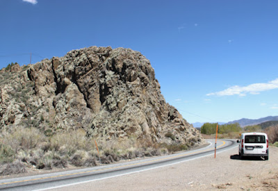
If you wander the summit of the Laramie Mountains as dusk falls, chances are you will spot mysterious creatures silhouetted against the evening sky—giants forever waiting by their castles, life-like but never moving. But if you get too close, they disappear, no matter how stealthily you approach. In their place are peculiar stacked stones and huge rounded masses of rock.

These are our tors (from the Old Welsh "twr" meaning pile or cluster). In shapes ranging from rounded blocks to dancers, turtles, beehives, and potato chips, they inhabit magical places like Vedauwoo, Blair, and the Devils Playground. But why? How and when did such fantastical beings appear?

Pioneering geologist Ferdinand Vandeveer Hayden once admonished humanity for not asking such questions. "Like the ripe fruits which so many pluck from the tree, and enjoy without a further thought, [landscapes] are accepted by mankind, and how few are thoughtful enough to inquire from whence they come!"

But not us, Professor Hayden. We are among the thoughtful few!


Monuments left by erosion, pleasing in their variety

Hayden's complaint appeared in his 1871 Preliminary report of the U.S. Geological Survey of Wyoming, specifically in the section about the Laramie Mountains, which he had crossed by train the previous year. At the crest, he came upon "scenery which is quite unique and remarkable, differing in many of its features from that at any other point along the [rail]road."

It was a landscape dominated by granite, as Hayden explained. The plateau-like summit was "literally paved with small fragments", and "massive piles, like the ruins of old castles, are scattered all over ... the difference in texture of the rock is such as to give a most pleasing variety, hardly any of these piles being alike."

Hayden then turned to the difficult question—from whence they come. "There is an interesting thought just here as to the real origin of these granitic, ruin-like piles that give the peculiar distinction to the plateau surface of the Laramie Mountains. I believe it is entirely due to erosive forces, which have operated here on a gigantic scale, and these cones and natural temples are the monuments that are left to tell the tale."

"I am convinced that the surface was at one time at least on a level with the highest of [the granite piles]." he continued. "How much more has been removed it is now impossible to tell, but I am convinced that comparatively few geologists have fairly estimated the immensity of the time required and the vastness of the amount of material removed from the surface by erosion."

Broadly-speaking, Hayden was correct. The tors of the Laramie Mountains were created by erosion. But there's much more to the story. It seems that erosion played multiple roles—shaping, revelation, and now destruction.

"Skull Rock ... has been peeled off, coat by coat, by the fingers of Time ..." wrote Hayden in 1871. (LOC).

A granite named Sherman

In early August 1907, the Laramie Republican (newspaper) announced the arrival of a "geological savant"—Professor Eliot Blackwelder, of the University of Wisconsin and the U.S. Geological Survey. He would study the surface geology of the southern Laramie Mountains, specifically the oldest rocks of the range.

For regular readers of this blog, "Eliot Blackwelder" may ring a bell. He appeared in a recent post about the Snowy Range, where he also studied ancient rocks. In fact, Precambrian rocks—the oldest on Earth—were Blackwelder's specialty.

Shortly after arriving, Blackwelder recruited an assistant—Herbert Kennedy, of the Republican's business department (he was replaced by his brother, Leon). Two days later, they left to set up their field camp near Tie Siding. They would work into late September, when Blackwelder returned to Wisconsin and Herbert Kennedy returned to his studies at the University of Wyoming.

In 1908, Blackwelder published "Pre-Cambrian rocks in southeastern Wyoming". He named the granite at the crest of the Laramie Mountains the Sherman granite, after the now-defunct Sherman railroad stop. The next year, in text accompanying geologic maps for the area, he described what he considered "the most important event of pre-Cambrian time in this district ... the intrusion of a vast mass of coarse-grained granite."

Rapakivi and grus—killer conversation starters

Like Hayden, Blackwelder was impressed by the small fragments that covered the ground to great thickness. "Although hard in its unaltered condition the Sherman granite disintegrates readily under the influence of descending surface waters and produces a coarse gravelly soil ... In excavations at Buford the granite has been found to be decayed to a depth of 40 to 50 feet ...".

This would greatly benefit the Union Pacific Railroad. The Buford quarry furnished trackbed ballast for 800+ miles of track, from Omaha to Rock Springs. From 1900 to 1914, an estimated 10,000 railcar loads were produced each year. Furthermore, Sherman ballast was cheap—a ton for just 6¢! —while average cost for the region was 49¢ per ton.

UPRR track builders approaching crest of Laramie Mountains on a bed of Sherman grus; 1867-68; Beinecke Library (cropped).

Because it breaks down so readily, geologists classify the Sherman granite as "rapakivi" ("mud rock" in Finnish). If wetted, mica in the granite expands, breaking the rock to create gravel, mainly crystals of feldspar and quartz. Geologists call this kind of decomposed granite "grus" (pr. gruce or sometimes gruss).

Blackwelder all but ignored the other remarkable feature of Sherman granite—the tors. He provided one photo and a single sentence. "Where thus deeply weathered, the outcrops of granite are smoothly rounded and free from visible ledges."

Sherman granite on crest of Laramie Mountains; looking north across "wide rolling plain of the mountain plateau". From Blackwelder's 1909 report (USGS); photographer unknown.

The problem of tors

Tors have long been mysterious and difficult to explain. One of the biggest obstacles is the many kinds, which likely differ in origin. Fortunately, the tors of the Laramie Mountains appear to be very similar to those of England, which have preoccupied humans for millennia. Perhaps their accumulated knowledge will provide some insight into the origins of our tors.

Haytor, perhaps the grandest of Dartmoor tors (southwest England; courtesy Smalljim).
The earliest accounts invoked mysticism and magic. Often tors were said to be living creatures turned to stone during some foolish encounter with a witch or the devil. A magical explanation for our tors would be wonderful, since the geology is complicated and still debated! But it appears there are none available, so we will rely on science.

English antiquarian and naturalist William Borlese of Cornwall may have been the first scientist to study tors. In a 1758 account, he concluded they were human creations, like the obvious constructions at Stonehenge. This was a popular theory for a time, but then geologists intervened.

Early on, geologists suggested that tors were once sea stacks—isolated stone towers just offshore. But sea stacks are angular and jagged, whereas the tors of England (and the Laramie Mountains) are distinctly rounded.

Sea stacks, Victoria, Australia; photo by Sam Abell.

Need to look in surprising places

In the second half of the 19th century, several English geologists made a conceptual leap. They spotted similar forms, not above ground, but in granite quarries! They realized that tors look very much like the quarryman's rounded "corestones" but with the "growan" (grus) removed. These geologists concluded that tors develop underground, where they wait to be revealed, whether by quarrymen or erosion.

In spite of the remarkable similarity of tors and corestones, this theory was largely ignored until 1955. That year, an English specialist in landforms, geomorphologist David Linton, published a paper explaining a process that could sculpt tors underground—"profound rock rotting." Groundwater flowing through fractured granite can break down narrow zones of rock, creating rounded blocks and filling the cracks with grus.

Profound rock rotting seems a likely explanation for our tors, made as they are from rapakivi granite!

Stages in the evolution of tors, by subsurface rock rotting (Linton 1955).

From birth to emergence

By now, readers surely are at the edge of their seats, eager to learn how our tors made it from their subterranean birthplace to the surface. But first we must backtrack 1.43 billion years. That is the estimated age of the Sherman granite, the time when it crystalized from molten magma, the actual birth of our tors. 

They may have remained in their infant form for hundreds of millions of years. Geologists still debate when shaping of the tors took place. The granite may have fractured when it solidified. Or maybe it happened later when erosion at the surface reduced pressure on the granite underground. Or maybe both! Nor is it clear when groundwater reached the fractured granite and began breaking it down. And there may have been several episodes.

We have a better understanding of how and when the tors were finally revealed at the surface. Their emergence is related to the Laramide Orogeny—the great mountain building episode that started 80 million years ago, lasted almost 40 million years, and created mountain ranges from Mexico to Canada—the Rocky Mountains.

It was during creation of the Rockies that the Laramie Mountains were uplifted. Like all mountains, as soon as they began to rise, erosion set in. This was erosion on a grand scale, just as Hayden suspected. After about 35 million years, enough overlying rock had been removed to expose the ancient Sherman granite. Grus in the joints was washed away, leaving behind our remarkable tors.


Visit our aging tors

Erosion hasn't stopped. It continues to slowly expose more tors, but it also destroys the ones we know and love. Wind, rain, and freezing remove a bit more rock every year. Occasionally a block falls! But from our perspective, ephemeral beings that we are, this destruction is incredibly slow. We still have time to enjoy our tors, so let's go!

From Interstate 80 about 15 miles east of Laramie, take the Vedauwoo Road east. Drive a quarter mile beyond the entrance to Vedauwoo Glen (fee area) to a grus-covered parking area on the left (free, with bathrooms). Follow the grus-covered trail past an interpretive sign and Pedestal Rock. Look for low mounds of granite—are these young tors emerging from below? or fallen blocks buried in grus? Curve left uphill and through a gate. Wander to the right across a large slab of Sherman granite. Note crystals of pink and white feldspar, sparkly quartz, and black biotite mica between the patches of lichen. Take in terrific views of tors, pleasing in their variety, just as Hayden said. Explore cracks and gullies to see decomposing rapakivi granite.

The best time to visit is during the golden hour before sunset—the magic hour when the light is warm and soft. You will be tempted to stay longer. But if dusk falls, do take care, lest you too be turned to stone!

Vedauwoo tors during the golden hour, not long before dusk.

This post is based on an article I wrote recently for the Laramie Boomerang's "History" column. In case you're wondering, I don't believe in magic ... under normal circumstances.

Monday, September 13, 2021

Green and Red; Stipules and Suckers

In the foreground is skinny Spike, the hawthorn. Behind is Flash, the maple (red canopy).
Since my last report, there has been only a little change in the trees I'm following. Flash's canopy has become even more red, though we've had nothing close to a frost. Spike is still a skinny odd-looking "tree".

Flash has only a few green leaves. The foliage is pretty ragged all in all.
When backlit, the aging samaras (keys) are still beautiful.
For Spike, it is the young leaves that are reddish. The rest are still green.

Now, for botany nerds ...

This month, Spike brought up several botanical terms which I "know" but not really; terms I've heard and even used for decades, but when pressed to explain, can't. At least not confidently. So I asked Google, the expert on everything (we hope).

Stipule: "an outgrowth typically borne on both sides (sometimes on just one side) of the base of a leafstalk (the petiole). Stipules are considered part of the anatomy of the leaf ..."

If you like order, stipule classification is for you! There are types based on many different characteristics, such as duration, shape, size, position, modification, and more. I preferred the summary of function: "Stipules have various functions. Some stipules are not well understood or may be vestigial." This is the way I feel about many things these days.

This hawthorn has foliaceous stipules, i.e., similar to leaves. Being green, perhaps they contribute to photosynthesis—the business of making energy for the tree. I would guess Spike could use the help, having recently recovered from near death. And maybe this is why stipules are more prominent on the suckers (the next topic).

Enlarge to see stipules at base of leaves.
Suckers seem to be universally despised, according to Google. For example, "young stems sprouting from the base or from a spot on the trunk ... are called suckers, because they zap water and nutrients from the main tree. As suckers are unhealthy for trees and they are unsightly, it’s important to know how to eliminate them ..." More here.

The Wikipedia article about Plant Development is more open-minded (see Adventitious structures; Buds and shoots). "Adventitious buds [buds that develop in unusual locations on the plant] are often formed after the stem is wounded or pruned. The adventitious buds help to replace lost branches." I agree! Adventitious shoots are very helpful in this situation.


This is my September report for the monthly gathering of tree-followers kindly hosted by The Squirrelbasket. Worried about another long covid winter? Consider joining us. Tree-following is a good diversion, even in winter, and it's stress-free! More information here.

Tuesday, September 7, 2021

Where on Earth did western Nevada go?

Does the Siberian craton include part of Nevada? (source; text added).
Nevada geologists claim that their state is diverse. I think they're right. On my recent geotrip across the central part, I saw rocks and features dating from Paleozoic time to recent, from the 370-million year old limestone of Devils Gate to a 57-year old fault scarp. However, I saw nothing Precambrian. That's not because Nevada didn't exist then; it did. But now half of Proterozoic Nevada is buried, and the other half is ... GONE!

There are geologists who specialize in running plate tectonics backwards. Using a variety of evidence, they trace the paths of Earth's lithospheric plates to deduce earlier arrangements of continents. They've had some success. For example, there is general agreement that multiple smaller continents (like today) have alternated with a single or several supercontinents. But exactly how continents collided to become a supercontinent, and then how the supercontinent broke up and where the pieces went, are puzzles not easily solved.

A rift runs through it

In the late Proterozoic, roughly a billion to 700 million years ago, Earth's land masses were aggregated into a supercontinent named Rodinia (Russian for "homeland"). Then it broke up into multiple continents and terranes (smaller fragments). The ones that concern us here are Laurentia (predecessor of North America), Siberia (a separate continent then), and Eastern Antarctica.
A reconstruction of Rodinia about 900 million years ago (source); text added.
During Rodinia's breakup, a rift developed across what is now Nevada, from roughly northeast to southwest (modern day compass directions). Eastern Nevada remained part of Laurentia while western Nevada drifted away; they were separated by a widening sea.

Fortunately (for those of us who love such things), the Laurentian coastline is still with us, now called the "0.706 line". It was detected by analyzing many granitic igneous intrusions emplaced long after rifting. The rising magma passed through rocks dating from the time of Rodinia's breakup, and in the process, material from those rocks was assimilated, including two strontium isotopes—87Sr and 86Sr. This is helpful! In continental rocks, the ratio of the two isotopes is greater than 0.706; in seafloor rocks, it is less. So strontium ratios reveal where the late Proterozoic continent and seafloor met.
The 0.706 line (after Kistler & Ross 1990).

Whither western Nevada?

Returning to the original question, where did the continental fragment west of the rift go? Since it was once continuous with eastern Nevada, surely it remains similar in some way—perhaps sharing the same rocks or geological structures. So have geologists wandered the world searching for a similar chunk of continent? Of course they have!

A leading contender resides in the Siberian craton in northeast Asia. The evidence is persuasive. The Sette Daban area of Siberia and the Death Valley area in southwest Nevada share "remarkably similar" sequences of Precambrian sedimentary rocks. In both locations, these "consist of five or six variegated siliciclastic-dolomite cycles that are each made up of numerous smaller cycles ..." (MacLean 2009). Similarity at such a fine scale is compelling.

Furthermore, fossils of the two areas are similar. Especially notable are the trilobites, which usually are limited in distribution. Shared types suggest the two areas were in close proximity. Geologic features are shared as well. Dike swarms and orogenic belts align nicely when the northeast margin of the Siberian craton is placed adjacent to western Laurentia (Sears & Price 1978).
Proposed reconstruction of Rodinia ~ 1 billion years ago (Sears & Price 2003). Shared orogenic belts underlined in red ("NV?" also added).
However, other work suggests that before drifting off, Siberia was joined to Laurentia far north of today's Nevada. For example, McClean et al. (2009) showed that Large Igneous Provinces in northern Laurentia and Siberia are of similar age and chemical composition ... also persuasive evidence!

But of course if we rule out Siberia, we must return to our original question. Where is Proterozoic western Nevada—where did that rifted fragment go?!

Maybe Antarctica?

Goodge et al. (2008) think they've found it in East Antarctica, which is composed largely of Precambrian craton fragments, including rocks not unlike those buried in eastern Nevada. They also cite a boulder (found in a moraine) of a somewhat unusual granite—Type A or rapakivi. It is similar to a zone of rapakivi granites that crosses North America/Laurentia, dated at ~1.4 billion years.
Rodinia 750 million years ago; red dots are ~1.4 Ga rapakivi granites (Goodge et al. 2008) ("NV?" added).
But more work is needed. Most bedrock of Eastern Antarctica is covered in ice year round. It's difficult to get a comprehensive picture from corings and rocks in moraines.

Next question

While the plate reconstructionists haven't yet answered our question as to whither, we do know that Proterozoic western Nevada is gone. Furthermore, the growing ocean that separated it from Laurentia has disappeared too. So what makes up western Nevada now? Stay tuned.
Pine Nut metavolcanics in western Nevada—a traveler come to rest.

Sources

DeCourten, F. 2003. The Broken Land; adventures in Great Basin geology.

DeCourten, F and Biggar, N. 2017. Roadside Geology of Nevada.

Goodge, JW, et al. 2008. A positive test of East Antarctica-Laurentia juxtaposition within the Rodinia supercontinent. Science 321, 235–240.

Kistler, RW, and Ross, DC. 1990. A strontium isotopic study of plutons and associated rocks of the southern Sierra Nevada vicinity. USGS Bull. 1920.

MacLean, JS, et al. 2009. Detrital zircon geochronologic tests of the SE Siberia-SW Laurentia paleocontinental connection, Stephan Mueller Spec. Publ. Ser., 4, 111–116, https://doi.org/10.5194/smsps-4-111-2009 

Piper, JD. 2011. SWEAT and the end of SWEAT: the Laurentia–Siberia configuration during Meso-Neoproterozoic times. Int. Geol. Review 53.

Sears, JW, and Price, RA. 1978. The Siberian connection: A case for the Precambrian separation of the North American and Siberian cratons: Geology 6: 267–270.

Sears, JW, and Price, RA. 2000. New look at the Siberian connection: No SWEAT. Geology 28.

Sears, JW, and Price, RA. 2003. Tightening the Siberian connection to western Laurentia, Geol. Soc. Am. Bull. 115.