Showing posts with label Colorado Plateau. Show all posts

Sunday, June 15, 2025

A Restless Region on the Colorado Plateau

Castle Valley, 20 miles east of Moab, UT; Round Mountain rises from the valley floor on the right.
The Colorado Plateau is a thick block of crust in the Four Corners area of the American Southwest, an immense stack of sedimentary rock. It's remarkably stable, remaining a region of geological calm even when severe deformation was underway right next to it—uplift and faulting of the Rocky Mountains to the east, and stretching and breaking of the Basin and Range Province to the west. This is why the Plateau's sedimentary rocks are largely horizontal, like the deposits they once were (source).

This is not to say the landscapes are boring. In fact they're spectacular—sweeping vistas with colorful roughhewn features. For the last 10 million years the Plateau has been rising, invigorating streams and accelerating erosion. The result is a seemingly endless collection of buttes, arches, rimrock, fantastical spires, deep winding canyons, and more.

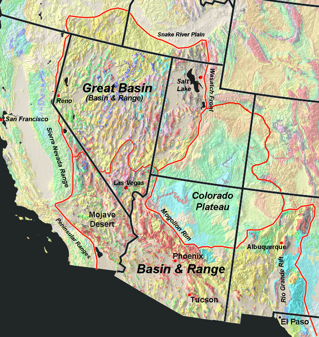
The Colorado Plateau covers c. 130,000 sq mi; note complex topography in adjacent areas (source unknown).
Valley of the Gods near Bluff, UT; vertical and horizontal erosional features are common on the Colorado Plateau.
Entrenched meander of the San Juan River, cut through horizontal strata; Goosenecks State Park.
Looking down Castle Valley. Is this a standard Colorado Plateau landscape? Bryant Olsen photo.
Castle Valley appears to be dominated by vertical and horizontal features, as is typical on the Colorado Plateau. Is it another example of recent uplift and erosion? Only partly. Its story is much more complicated—repeated flooding, prolonged deposition, unusual deformation, weird intrusions, and finally ... collapse.

About three hundred million years ago, not far east of today's Castle Valley, the great Uncompahgre Range was rising. At the same time the Paradox Basin was subsiding along the range's base, and filling with sediments eroded off the mountains. Critical to the Castle Valley story, seas repeatedly flooded the Basin (1). Then whenever sea level dropped, the saltwater left behind evaporated and deposited evaporites, including lots of salt (halite). At least 29 such cycles took place over a period of at least 8 million years. The result was extensive deposits of evaporites at least 4000 ft thick—the Paradox Formation (2).
Ancestral Rocky Mountains c. 300 million years ago; darker blobs are major ranges; Castle Valley location approximate (modified from Soreghan et al. 2009).
Being evanescent creatures, it's difficult for us to think of geologic structures as ephemeral. But the rock record clearly shows that they are. Even mountains have lifetimes. The great Uncompahgre Range is now gone, razed by erosion. The Paradox Basin also disappeared, filled to overflowing with sediments and then deeply buried. But in a sense both are still with us. Uncompahgre sediments are widely displayed in colorful rocks across the Colorado Plateau. And the Paradox Basin maintains a ghostly presence—dramatic, but difficult to explain.

After deposition of the last Paradox evaporites, the region was inundated by tropical seas—source of the impressive layers of limestone, sandstone, siltstone and shale that line Plateau drainages. Then about 200 million years ago, when the supercontinent Pangaea started to come apart, there was a shift to terrestrial deposits—dune sand, volcanic ash, and sediments from rivers, lakes, and inland seas. Under this immense "lithic layer cake" lay the Paradox salt, deeply interred but not dead (source).

Salt is a strange kind of sedimentary rock. Sediments such as sand and mud can be compressed to form dense rocks, but salt remains nearly unchanged under pressure. It's weaker and less dense than the rock around it, but also plastic—with properties of both solids and liquids. It can flow to escape from its "stressful surroundings", deforming any rocks in its way (source). Deformation can occur at the scale of landscapes, and the old Paradox Basin has many fine examples: fins and arches of the Fiery Furnace, closely-spaced meanders on the Colorado River, and at least seven parallel northwest-trending valleys, including Castle Valley.
Dotted elongate blobs are parallel northwest-trending valleys. Blue circle marks intriguing overlap of Castle and Spanish Valleys with La Sal Mountains (3). Modified from Doelling 1985.
Castle Valley begins at the base of the northern La Sal Mountains and extends northwest about 12 miles. It's a broad valley, to 2 miles wide. The southwest wall is capped by a nearly continuous outcrop of the erosion-resistant Wingate Sandstone, known as Porcupine Rim. On the other side of the valley, the wall is less continuous but equally dramatic—carved into mesas, buttes, rimrock and spires.
Porcupine Rim—Jurassic Wingate Sandstone caps southwest wall of Castle Valley.
Northeast side of Castle Valley; strata tilting away from valley center visible at arrow.
Geologists find Castle Valley intriguing. The floor is much broader than would be expected for its little streams, and quite flat. Rock layers on both sides of the valley tilt down away from the valley center (more easily seen on the northeast side, photo above). Most exciting is what lies beneath the surface. Wells drilled in the center of the valley revealed a long steep-sided bed of salt to 1000 feet thick! Castle Valley must be a salt anticline, an elongate convex uplifted fold cored by salt. On this geologists agree. But as to how it formed and what happened to it ... that's another matter.
Castle Valley (Google Earth). But where's the anticline?! Valley walls hint at what happened.
The diagram below shows a common explanation for salt anticlines. In the top panel, flowing salt accumulates to form a convex fold, pushing up overlying rock layers. Castle Valley salt is thought to have flowed and formed an anticline 300 to 200 million years ago (Ornduff 2006, Trudgill 2011).
Salt anticline in cross section; at the time of the top panel, Castle "Valley" would have been a long ridge.
Now the Castle Valley anticline is mostly gone. The second and third panels in the diagram show a possible demise, but first, a major disturbance very close by needs to be considered—uplift of the La Sal Mountains about 28–25 million years ago (3).

The La Sals are not a mountain range but rather clustered peaks. They're similar to volcanoes except that magma never reached the surface. Pioneering geologist AC Peale called them "eruptive mountains of a peculiar type ... igneous and yet non-volcanic". Recent studies indicate that magma stopped just 1–3 miles below the surface, making them shallow intrusions, specifically laccoliths.
La Sal Mountains rise 8000+ feet above the Colorado Plateau—a major disturbance! (source)
La Sal high country: La Sal Peak (right) is intruded trachyte; Castle Mountain (left) is still capped with sedimentary rock (Ross 1998).
Now we're faced with another question. If magma never reached the surface, why are the La Sal "intrusions" visible? Instead of being 1–3 miles below the surface, their tops stand over a mile above the Plateau. The likely answer is the recent uplift and erosion of the Colorado Plateau mentioned at the beginning of this post.

Starting about ten million years ago, both the Colorado Plateau and the Basin and Range Province (to the west) have been rising. But while the latter was stretched and faulted, forming its eponymous basins and ranges, the Plateau remained a single block. Eventually it rose about kilometer higher than the Basin and Range. Why? That's a puzzle not yet solved (source). In any case, streams were steepened and invigorated, and erosion sped up enough to reveal the La Sal laccoliths.

Recent uplift and erosion probably explain the demise of the Castle Valley anticline as well. Erosion and/or faulting of overlying rock would have exposed the salt to water. Being salt, it of course dissolved. When enough was removed, rock layers at the crest fractured and collapsed, creating a breached anticline. But others think differently. Regional extension may have been the cause, perhaps related to ongoing extension in the Basin and Range Province. Or as Naqi et al. (2016) safely concluded, "formation of the salt valleys might be attributed to multiple factors (i.e., extensional forces, salt dissolution, and internal salt flow) rather than a single mechanism."
A salt anticline's demise may start with salt dissolution, followed by collapse of rock layers at the crest.
Breached anticline; dashed line shows former continuity across crest (Grabau 1920, A Textbook of Geology).

Let's visit!

Castle Valley is a great destination for geotrippers. Enough remains of the anticline to see and appreciate what happened. The tilted rock layers of the flanks are now the valley walls. Imagine them reaching higher and arching across the broad floor. Consider the depth of the valley below the now-imaginary crest and think about how much salt and rock must have been removed! Then look toward the head of the valley, at the dark hill rising from the floor. That's Round Mountain—a little relative of the La Sal intrusions. It was exposed when the anticline was breached and deeply eroded.

Castle Creek Road (paved) runs the length of the valley, providing easy access. Spires, buttes and mesas on the northeast side can be reached from several parking areas. Round Mountain is a short distance south of Castle Valley Road via a rough eroded 2-track; I parked just off the paved road and walked. Tour the southwest side via the Porcupine Rim trail—highly recommended, though maybe not on weekends and holidays.
Castleton Tower is a short hike from Castle Valley Road.
La Sals on left, Round Mountain on right, rabbitbrush in foreground.
En route to Round Mountain, Porcupine Rim beyond.
Looking up Castle Valley from Porcupine Rim, La Sal Mountains on horizon; redrockrubi.
Refreshing shade, courtesy uplift and erosion of the Colorado Plateau.

Notes in addition to links in post

(1) Cyclicity of Paradox deposition is well documented, but the cause is debated. Glaciation seems to be most popular, specifically sea level change with alternating glacial and interglacial periods. Other possibilities include rise of the Uncompahgre Range and climate change. Trudgill (2011) concluded that glaciation-driven changes in sea level was the main cause; tectonics and/or climate change may have made lesser contributions.

(2) In my reading, I found a range of estimates for Paradox deposition: 29 or 33 cycles over 8 to 15 million years, producing evaporites 4000, 6000 or 8000 ft thick (Ornduff et al. 2006, Trudgill 2011, USGS).

(3) Geologists have long wondered whether the La Sal Mountain intrusions and salt anticlines such as Castle Valley are related. Thomas Harrison, who surveyed the Paradox Basin area in 1926, discussed the possibility in his report (1927):
"It is interesting to know that igneous intrusive rocks of very considerable importance are closely associated with the saline anticlines. The laccolithic La Salle Mountains occupy an area on and between two parallel anticlines ... A small isolated igneous stock [Round Mountain] surrounded by gypsum occurs in the Castle Valley salt [anticline]."

Harrison noted that salt anticlines were thought to be associated with lines of weakness dating from Precambrian time. Their uplift was followed by subsidence, and massive accumulation of sediments. Perhaps this "heavy load" generated heat that "liquefied rocks within the zone of fracture, resulting in the [magma] which formed the laccolith, and the Castle Valley stock" [Round Mountain].

Today's geologists may chuckle at the idea of a "heavy load" of sediments melting igneous rock below. In contrast, "lines of weakness dating from Precambrian time" are taken seriously. Many northwest-trending faults cut basement rocks in the Paradox Basin area. Ross (1998) concluded that "the locations of the La Sal Mountains intrusive centers along the trend of subsurface faults ... suggest that the faults were avenues of weakness for the ascent of magma in the upper crust. This is especially true for the northern and southern clusters of peaks [which coincide with salt anticlines]".

Sources

Doelling, HH. 1985. Geology of Arches National Park. Utah Geological Survey, to accompany Map 74. PDF

Harrison, TS. 1927. Colorado–Utah Salt Domes. Am. Assoc. Petroleum Geologists 11:111–133.

Ornduff, RL, Wieder, RW, Futey, DG. 2006. Geology Underfoot in Southern Utah. Mountain Press Publishing. For salt anticlines see Vignette 29, A Sea of Fins; for La Sal Mountains see Vignette 32, Intruders in a Sedimentary Domain.

Ross, ML. 1998. Geology of the Tertiary intrusive centers of the La Sal Mountains, Utah; influence of preexisting structural features on emplacement and morphology, in Laccolith complexes of southeastern Utah; time of emplacement and tectonic setting. USGS Bull. 2158: 61-83. PDF

Snyder, NP. 1996. Recharge area and water quality of the valley-fill aquifer; Castle Valley, Grand County, Utah. Report of Investigation 229. Utah Geological Survey. PDF

Soreghan, GS, et al. 2009. Hot fan or cold outwash? Hypothesized proglacial deposition in the upper Paleozoic Cutler Formation, western tropical Pangea. J. Sed. Res. 79:495-522.

Trudgill, BD. 2011. Evolution of salt structures in the northern Paradox Basin: controls on evaporite deposition, salt wall growth and supra-salt stratigraphic architecture. Basin Research 23:208–238. https://onlinelibrary.wiley.com/doi/10.1111/j.1365-2117.2010.00478.x

US Geologic Survey. Mid 2000s. Geologic Provinces of the United States: Colorado Plateau Province. Internet Archive WayBackMachine.

Tuesday, April 8, 2025

Peculiar Eruptive Mountains on the Colorado Plateau

The La Sal Mountains rise 8000+ feet above the Colorado Plateau (source).
In 1875, two geologists employed by the US government were studying mountains in southeast Utah. They worked 90 miles apart, each one in an isolated cluster of peaks rising above the mostly horizontal Colorado Plateau. They found the same strange type of structure and the same kinds of igneous rocks, and in their reports published two years later, they reached the same conclusions.

Albert Charles Peale was an employee of the War Department, specifically the Geological and Geographical Survey of the Territories led by Ferdinand Vandeveer Hayden. His party—one geologist, two topographers, two packers, and a cook—was surveying the Grand River District in western Colorado and eastern Utah (1). They spent a week in the Sierra la Sal, "which afforded magnificent opportunities for work" and then headed south. But hostile locals ("Indian trouble") brought field work to a sudden end. In their hasty exit, "all [rock] specimens had to be abandoned."

Grove Karl Gilbert was an employee of the Department of the Interior, specifically the Geographical and Geological Survey of the Rocky Mountain Region led by John Wesley Powell. On his descents of the Colorado River, Powell had seen an unmapped cluster of peaks to the west, which he named the Henry Mountains (2). They looked volcanic—domed, with dark lava-like rock on the top. Volcanology was a young science then, and geologists were debating whether volcanos were elevated craters or built from accumulated lava. So Powell sent Gilbert to the Henrys to "determine the facts" (Hunt 1988). He and his party stayed two months, more than enough time to answer the volcano question.

Peale worked in the La Sals, Gilbert in the Henrys; map based on data from National Atlas, labels added.
That winter Peale wrote up his findings, but two years would pass before Geological Report on the Grand River District was published (3). He estimated they had surveyed 6000 square miles of which "the greater part ... is plateau in character, the Sierra la Sal being the only mountain group." It was an isolated cluster of about 30 peaks arranged in three "eruptive centers". Peale was emphatic about origins: "there can be no doubt of the eruptive character of the mountains... porphyritic trachyte has been pushed up through the sedimentary layers which now dip away from the mountains" (Peale 1877a).

Peale called the La Sals "eruptive mountains of a peculiar type ... igneous and yet non-volcanic" (1877b). They were non-volcanic because lava didn't reach the surface. But neither were they plutons emplaced deep underground. Instead, magma had stopped somewhere in between, deforming the overlying rocks. The intruded rock was exposed much later by erosion. There was no name for this type of structure, so he described it in detail, pointed out its peculiarity, and left it at that.

Sections across Sierra la Sal showing tilted sedimentary strata on intruded trachyte (Peale 1877a, cropped).
From the Sierra la Sal, Peale studied the Henry Mountains off to the west. He knew John Wesley Powell (Gilbert's boss) thought they were volcanic—"the summits of these mountains mark in reality the level of former valleys down which the volcanic material flowed" (Powell 1875, quoted by Peale). But even from ninety miles away Peale could see that was incorrect. "l am inclined to class the Henry Mountains with the Sierra la Sal and Abajo [Mountains], as their outline is similar ..."

From his vantage point in the heart of the Henrys, Gilbert "agreed" with Peale (unknowingly). The peaks were neither elevated craters nor accumulated lava nor even volcanic. In fact they were a novel type of structure, as he warned his readers:

"If the structure of the mountains be as novel to the reader as it was to the writer, and if it be as strongly opposed to his preconception of the manner in which igneous mountains are constituted, he may well question the conclusions in regard to it while they are unsustained by proof. I can only beg him to suspend his judgment until the whole case shall have been presented." (Gilbert 1877)

Gilbert gave the novel structure a name—laccolite—thereby making the Henry Mountains the type locality for laccoliths (today's term). He distinguished them from volcanic eruptions, where lava reaches the surface and accumulates. "The lava of the Henry Mountains behaved differently ... it stopped at a lower horizon, insinuated itself between two strata, and opened for itself a chamber by lifting all the superior beds."

Gilbert's sections across the familiar Mountain of Eruption (volcano) and the novel Laccolite.
Like Peale, Gilbert had to wait two years for publication of his findings. He finished his monograph the winter after his second season in the Henrys. "It was at once put in type, and in anticipation of a speedy issue the current year [1877] was marked on the imprint..." But the many illustrations caused delays. Geology of the Henry Mountains was finally bound and distributed in 1879.

By that time a wealth of information about igneous mountains had accumulated, prompting Gilbert to prepare a second edition (1880). It differed from the first mainly in the addition of an Appendix: Recently Published Descriptions Of Intrusive Phenomena Comparable With Those Of The Henry Mountains. At the end of the section about Peale's findings in the La Sals, Gilbert concluded, "All of these features are paralleled in the Henry Mountains and they leave no reasonable doubt that the structures are identical."

I visited the Henry Mountains in 2012, accompanied by the spirit of Grove Karl Gilbert. I camped at Starr Springs as he had, and hiked to the spectacular south face of Mount Hillers, "revetted by walls of Vermilion and Gray Cliff sandstone" as he explained.

South face of Mount Hillers—steeply tilted sandstone on flanks, intruded trachyte on crest (Jack Share).
Vermillion sandstone "tilted almost to the vertical".
Since then, I've been keen to visit more of the peculiar eruptive mountains on the Colorado Plateau. Last September I finally did, spending a week in the Sierra la Sal.
La Sals upper right; snow highlights 3 clusters of peaks. Upheaval Dome upper left. (Google Earth)
Peale's three eruptive centers live on, though they're now called intrusive centers ("eruptive" means volcanic). But these are special intrusions—emplaced at depths intermediate between volcanos (surface) and plutons (deep). They now have their own descriptor—hypabyssal, aka subvolcanic (but still laccoliths).
Two hypabyssal intrusion-cored peaks: Castle Mountain (left) retains a cap of sedimentary rock; La Sal Peak (right) is trachyte (Ross 1998, cropped).
The three intrusive centers of the La Sal Mountains are conveniently named northern, middle, and southern (4). All normally are accessible via the paved Loop Road, but road construction kept me in the northern one. From a very nice small primitive campground, I hiked to see what I wanted to see—the distinctive features of these peculiar eruptive mountains.

It was a short walk to Castle Valley Overlook with views of the Colorado Plateau. The Plateau doesn't look horizontal, but the rock layers are. The spectacular landforms—towers, buttes, rims. deep winding canyons—are erosional. True uplifts like the La Sal Mountains are uncommon. Gilbert called them "disturbances in a region of geological calm."
Looking northwest near Castle Rock Overlook; in the valley bottom left of center is Round Mountain, a small intrusion perhaps connected to the La Sals.
Let's head on down and see what we can see.
Among Peale's important observations were tilted sedimentary strata that "now dip away from the mountains". He concluded they were pushed up and tilted by rising magma. The hike provided good views of steeply tilted sedimentary rocks.
Nearly vertical beds of reddish sedimentary rocks below trachyte slopes of Grand View Mountain (left); high peaks visible on horizon just right of center.
With part of the Loop Road closed, the high peaks weren't easy to access. So the next day we hiked up a rough dirt road to view trachyte. It's common above the flanking sedimentary rocks, forming steep slopes and discouraging travel as Peale noted. "The only difficulty met with in the study of this interesting region is the great amount of debris that has accumulated ..."
Some kind of outcrop (could be rhyolite) beyond steep slope of "debris".
Trachyte with a dark xenolith—country rock broken off and carried up by magma. 
Fall colors on trachyte.
Mount Peale, a large laccolith and high point of the La Sals (Suffusion of Yellow).
Peale was hesitant to identify the igneous rock of the La Sals, without specimens to give to petrologists for "critical examination". But it looked very much like rock he had seen in similar intrusions in Colorado. So he assigned it to a general category—porphyritic trachyte. It seems trachyte was the accepted name for shallow intrusive rocks low in silica in Peale's time (see Appendix in Gilbert 1880). Now it may be trachyte or diorite, depending in part on whom you ask (5). Being very much a 19th century naturalist at heart, I will stick with trachyte.

On the other hand, everyone agrees the rock is porphyry—visible crystals (phenocrysts) in a fine-grained matrix of trachyte. This is a very cool rock, with an interesting history. As the magma rose it gradually lost heat, eventually dropping to a temperature where hornblende and plagioclase formed crystals. This changed the composition of the remaining molten magma, and when it stopped c. 6–10 km below the surface, it rapidly crystallized to form the trachyte matrix (Ornduff et al. 2006; see also Fractional crystallization).
Porphyritic trachyte mementos from Henry Mountains (left) and La Sal Mountains.
As I drove away from the La Sals, I thought a lot about the pioneering geologists of the American West. Like me, they were inspired by geology and the beauty of the landscapes, but their geotripping was very different. Travel (route-finding required) and camping were much more challenging. And where specifically should they go? (no guidebook). However they had the promise of discovery, which surely made up for all the hardships!
AC Peale and two unidentified men, probably during the
Geological & Geographical Survey of the Territories (Smithsonian Archives).

Notes

(1) The Grand River was the section of the Colorado above the confluence with the Green. Its name was changed in 1921.

(2) Powell named the cluster of peaks for Joseph Henry of the Smithsonian Institution, who helped secure funding for Powell's exploration of the Colorado River.

(3) Publication of Peale's report was delayed through no fault of his own. As his boss, FV Hayden explained, it was caused by "the great increase of labor incident to the International Exposition at Philadelphia", labor that would have gone toward preparation of reports. In general, the regular Reports of the Geological and Geographical Survey of the Territories were inadequate for sharing discoveries. In 1874, a new publication—Bulletins— was created to "publish without delay ... new or specially interesting matter". Peale had an article in Bulletin No. 3, about the peculiar eruptive mountains of Colorado and adjacent Utah, including the La Sals (1877b).

(4) Some sources refer to the La Sal intrusive centers as composite plutons or coalesced intrusions.

(5) Ross (1998) reported that La Sal igneous rocks were 59–71% Si02 (silica), and called them trachyte based on "the Total Alkali-Silica classification of LeBas and others". Wilson and others (2016, based on reports from 1953, 1959, and 1992) reported that igneous rocks of the Henry Mountains were 58–63% SiO2, and called them diorite. (Thanks to Mike for taking a stab at trachyte vs. diorite.)


Sources

Bartlett, RA. 1962. Great Surveys of the American West. Norman, OK: University of Oklahoma Press.

Fillmore, R. 2011. Geological evolution of the Colorado Plateau of eastern Utah and western Colorado. Univ. Utah Press.

Gilbert, GK. 1877. Report on the Geology of the Henry Mountains. GPO. BHL.

Gilbert, GK. 1880. Report on the Geology of the Henry Mountains. 2nd edition. GPO. Google Books PDF. Appendix p 153–161 contains added material about igneous mountains.

Gould, LM. 1927. Geology of the La Sal Mountains, Utah Papers of the Michigan Academy of Science, Arts and Letters Vol. 7: 55-106. HathiTrust

Hunt, CB. 1958. Structural and igneous geology of the La Sal Mountains, Utah. USGS Professional Paper 294-1. PDF

Ornduff, RL, Wieder, RW, Futey, DG. 2006. Geology Underfoot in Southern Utah. Mountain Press Publishing. (see Vignette 32, Intruders in a sedimentary domain)

Peale, AC. 1877a. Geological report on the Grand River District, in Hayden, FV. Ninth annual report of the United States Geological and Geographical Survey of the Territories (p. 31–101). BHL

Peale, AC. 1877b. On a peculiar type of eruptive mountains in Colorado. Art. XVIII in US Geological and Geographical Survey of the Territories Bulletin No. 3: 551–564. BHL

Powell, JW. 1875. Exploration of the Colorado River of the West. Geographical and Geological Survey of the Rocky Mountain Region (Henry Mts p. 200-203).

Ross, ML. 1998. Geology of the Tertiary intrusive centers of the La Sal Mountains, Utah; influence of preexisting structural features on emplacement and morphology in Laccolith complexes of southeastern Utah; time of emplacement and tectonic setting. USGS Bull. 2158: 61-83. PDF

Wilson et al. 2016. Deformation structures associated with the Trachyte Mesa intrusion, Henry Mountains, Utah, Implications for sill and laccolith emplacement mechanisms. J. Structural Geology 87: 30-46. free online

Friday, July 20, 2018

Volcanoes in Utah? How can that be?!

Black Rock Desert volcanic field in western Utah.
Volcanic eruptions have been big news lately, with graphic accounts from Hawaii, Bali and Guatemala, and fearsome stories of much greater destruction not so long ago. Yet most of us consider volcanism no threat to us personally. And we’re right. In the greater scheme of things, volcanoes are rare.
A volcano won’t erupt in your cornfield unless you farm in just the right place (Paricutín 1943).
Volcanoes are born when magma forces its way to the surface and becomes red-hot oozing lava, or a fiery fountain of ash and fractured rock, or a racing incandescent cloud that hugs the ground and incinerates everything in its path. But magmas don’t form just anywhere. They—and therefore volcanoes—require special circumstances.
Magma was once thought to flow from Hell, e.g. via Iceland’s Mount Hekla, the Gateway to Hell (source).
Magma is liquid rock, specifically silicate rocks (rich in SiO2). Therefore none of the layers of the Earth qualifies as a direct source of magma. Crust and mantle have the proper composition but are solid. The outer core is liquid, but the composition is wrong—iron and nickel. Therefore magmas must be melted mantle and crust (1). But what is the source of heat for melting? It’s here that debates rage.
Earth’s structure can be described by physical properties or by chemical composition; see (2). For this post, only “mantle” and “crust” are used, as is common in less technical discussions. Modified from Nelson 2015.
Global distribution of volcanoes coincides with certain types of plate boundaries (USGS via wikimedia).
A world map of active volcanoes reveals a suggestive pattern. Most line up along plate boundaries—where the shifting plates that make up the Earth’s surface collide, override, jostle and split in the dance of plate tectonics. This is an appealing pattern because several types of plate interactions could facilitate melting to form magma. Decompression melting probably occurs at divergent boundaries such as mid-oceanic ridges and rift valleys. At convergent boundaries (subduction zones), addition of water could lead to flux melting (Nelson 2015; OSU Volcano World).

But not all volcanoes conform to the pattern. Some erupt far from any plate boundary, and these intraplate volcanoes are difficult to explain.
Above and below, Ice Springs basalt flow in the Black Rock Desert, the most recent volcanic eruption in Utah. But why here?
Looks fresh enough to have erupted last year!
The Black Rock Desert volcanic field (3) is located about 120 miles south of Salt Lake City, Utah, well into the interior of the North American plate. It covers almost 2700 sq mi (7000 sq km), and includes shield volcanoes, cinder cones, lava domes, lava flows, maars and possibly a caldera. All are Quaternary in age, having erupted in the last 6 million years—most in the last 2.7 million. In other words, this field is young—and may still be active.

The field sits at the eastern edge of the Basin and Range Province, just west of the Colorado Plateau. Herein may lie an explanation for the intraplate volcanism. Though far from a plate boundary, this part of North America is hardly stable. Big changes are underway.
Quaternary volcanic fields are common in the Basin and Range Province and on the margins of the Colorado Plateau; modified from Valentine et al. 2017.
West of the Black Rock Desert, the Basin and Range Province has been expanding east-west for the last 30 million years, increasing the distance to the West Coast by 250 miles. Crustal extension may explain, at least in part, the Province’s thin crust; the mantle (asthenosphere) is only about 17-18 miles below the surface. And crustal thinning may explain (partly) the many Quaternary volcanic fields (map above).

Just east of the Black Rock Desert is the Colorado Plateau, which is very different from the Basin and Range Province. It’s a big chunk of crust that is thick (25-30 miles) and relatively undeformed. Volcanism is mostly restricted to the margins. Yet the Plateau is changing too. Precise GPS measurements show it's slowly rotating clockwise (4).

Most intriguing is the boundary between the extending Basin and Range Province and the rotating Colorado Plateau (5). It just happens to be lined with Quaternary volcanic fields, including the Black Rock Desert! Surely there’s a story here!!
Note volcanism along Colorado Plateau margins (Spence & Gross 1990).
In fact, there are multiple stories, all based to some degree on speculation. The earliest invoked a rising plume of hot mantle material over which the continent drifted, producing a line of progressively younger volcanism. While a “hotspot” model works well in Hawaii, it would be awkward to apply to the Colorado Plateau, requiring multiple hotspots and/or varied direction of movement.

But there may be no need to invoke mantle plumes; plate dynamics may be enough (6). Rotation and/or extension could be fracturing the crust sufficiently to create conduits for magma, especially where the crust is thinner (DeCorten 2003; see also Recent Volcanic Activity in Northern Arizona which includes discussion of western Utah). Or perhaps magma is rising through fractures in reactivated ancient crustal sutures (see my Jemez Lineament post). Ballmer et al. (2015) suggest that the difference in thickness between Basin and Range crust and that of the Colorado Plateau may affect mantle flow and cause decompression melting.
Looking north from Tabernacle Hill across basalt flows toward Pavant Butte, a large tuff cone.

Whatever the cause of magma generation, it seems likely that Black Rock Desert volcanism will continue. Little if anything has changed since the last eruptions, just 700 years ago. Basin and Range crust is still stretching, the Colorado Plateau is still rotating, and local mantle flow likely hasn’t changed much.
“There is really no more reason to believe that the epoch of basalt has closed in this region, than that it has barely begun; and it is certainly probable that the few centuries we can know by history and tradition, belong to one of the intervals of quiet, such as separate the more or less convulsive efforts of volcanoes; an interval to be terminated sooner or later by a renewal of activity.” Grove Karl Gilbert, 1875
Pavant Butte, from GK Gilbert’s 1890 Lake Bonneville monograph (USGS).
“Lava from valley of lower Sevier Utah” (Black Rock Desert; Gilbert 1875).

Utah’s Black Rock Desert lies just west of Interstate Highway 15 near Fillmore. Geo-tripping is convenient and fun. Most sites are on public land, and accessible by gravel and passable dirt roads. A wealth of geo-info makes the area especially interesting, ranging from the excellent Millard Country travel brochure to the scientific literature. In May I spent a week there, which wasn't nearly enough. More posts from the trip will be up soon.
"Volcanic District near Fillmore, Utah" (Gilbert 1890).

Notes

(1) Properly speaking, magma forms from partial melts—of mantle rock most often and occasionally crust.

(2) Two systems are used to describe Earth structure: physical properties and chemical composition. The resulting units are not equivalent. For example, based on physical properties, the outermost layer—the lithosphere—is solid brittle rock. But the lithosphere includes two different rock types based on chemistry—crust and uppermost mantle. Another example: the mantle is thought to be uniform chemically, but has three zones based on physical properties: the solid brittle part in the lithosphere, a solid but ductile asthenosphere directly below, and the solid mesosphere (source).

(3) This is not the Burning-Man Black Rock Desert of northwest Nevada.

(4) Estimated rotation rate for the main body of the Colorado Plateau is 0.103 ± 0.017° per Ma. Rates at the margins appear to be affected by Basin and Range extension (Kreemer et al. 2010).

(5) The western margin of the Colorado Plateau is sometimes called the Basin & Range Colorado Plateau Transition Zone (map courtesy Utah Geologic Survey).
(6) For more about the raging plume-ist vs. plate-ist debate, see Jack Share’s The Geologic Evolution of Iceland—specifically “A NEW GEOLOGICAL PARADIGM” about 2/3 of the way through the post.


Sources

Ballmer, MD, et al. 2015. Intraplate volcanism at the edges of the Colorado Plateau sustained by a combination of triggered edge-driven convection and shear-driven upwelling. Geochem. Geophys. Geosyst., 16: 366–379. doi:10.1002/ 2014GC005641.

DeCourten, FL. 2003.  The Broken Land: adventures in Great Basin geology.  Salt Lake City, Utah: University of Utah Press.

Gilbert, GK. 1875. Report upon the geology of portions of Nevada, Utah, California, and Arizona, examined in the years 1871 and 1872, in Wheeler, GM, Report upon United States geographical surveys west of the one hundredth meridian, v. 3, Washington DC:GPO. https://www.biodiversitylibrary.org/bibliography/49058

Gilbert, GK. 1890. Lake Bonneville. USGS Monograph 1. Washington DC:GPO. https://pubs.er.usgs.gov/publication/m1

Johnsen, RL, et al. 2010. Subalkaline volcanism in the Black Rock Desert and Markagunt Plateau volcanic fields, in Carney, SM, et al., eds., Geology of south-central Utah. Utah Geological Association Publication 39.

Kreemer, C, et al. 2010. Present‐day motion and deformation of the Colorado Plateau. Geophys. Res. Letters 37: L10311. doi:10.1029/2010GL043374

Nelson, SA. 2015. Structure of the Earth and the origin of magmas. Tulane University EENS 2120 Petrology (online lecture notes).

Spence, W, and Gross, RS. 1990. A tomographic glimpse of the upper mantle source of magmas of the Jemez Lineament, New Mexico. Journal of Geophysical Research 95 B7:10,829-10,849.

Valentine, GA, et al. 2017. Lunar Crater volcanic field (Reveille and Pancake Ranges, Basin and Range Province, Nevada, USA) Geosphere13: 391-438. https://doi.org/10.1130/GES01428.

Volcano Hotspot. 2018-01-09. Recent volcanic activity in SW Utah.