Showing posts with label Basin and Range. Show all posts

Sunday, September 7, 2025

Desert Mountain—Utah's latest GeoSight

"now a quiet, remote monument to that violent geological time." (Smith 2025)
Desert Mountain's peaks and ridges lower right quarter of photo; white mark is high point (Google Earth).
Desert Mountain is small mountain—an isolated cluster of low peaks, ridges and knobs in Utah's West Desert. The first geologist to write about it thought "Desert Hills" more appropriate (Loughlin 1920). But its story is huge—complicated and filled with drama. And being geological, it's long.

We could start 300 million years ago, when collisions on both sides of a young North America were deforming it far inland, for example in today's western Utah. Or we could start 300 million years before that, when western Utah was covered in shallow water of the great Paleozoic Sea. Or we could go back yet another 300 million years to the creation of that sea, when the supercontinent Rodinia was coming apart. But we won't. Instead we'll start three months ago, on a hot spring day.

Shortly before I left home, the spring issue of Survey Notes showed up in my mailbox. Inside was a GeoSight—a new one, and in the general area of my travels. Of course I would go there! Of the many resources offered by the Utah Geological Survey (UGS), my favorite is GeoSights. I visited my first, the Honeycombs, in 2012. Awed by the rocks and their story, I've been geotripping to GeoSights ever since.
Sunset on the Honeycombs, 2012.
My visit to Desert Mountain was about 80 miles round trip from Delta. I took UT Hwy 6 north to the Jericho Callao Road, then drove west. Pavement soon gave way to gravel, a bit rough in places but generally good. The road crossed open juniper woodlands and sparse dry grasslands, with expansive playas to the south. After 22.5 miles, with Desert Mountain visible nearby, I stayed left at a junction and was soon at its base.
Approaching Desert Mountain from the north. Kelly Hewitt photo via Google Earth.
Rocks abound, trees not so much; pale band close to road is a fence covered in tumbleweeds.
The road continued along the base of a steep slope with granite outcrops, then climbed a short distance to Desert Mountain Pass where there was no shade to be had. I parked and reread Jackson Smith's GeoSight article inside the van, cooled by light breezes wafting through opened windows and doors.

Desert Mountain was born c. 30 to 40 million years ago, during the Great Ignimbrite Flareup which ravaged much of Nevada and western Utah. For 15 million years large volcanoes, supervolcanoes and complexes of supervolcanoes (1) produced on the order of 5.5 million km3 of volcanic material—great clouds of ash that blocked the sun, huge volumes of rock fragments hurled hundreds of miles, and searing pyroclastic flows that destroyed everything in their path. For comparison, the 1980 Mount St. Helens eruption produced only one km3 of material (source).
Geologic map shows rock units discussed here. Blue B's mark shoreline of glacial Lake Bonneville, black lines are faults, labeled arrows are mine (Smith 2025).
Today's rock outcrops suggest that the life of the Desert Mountain volcano had three stages. In the first, viscous rhyolite oozing from vents formed thick deposits of lava. Rhyolite outcrops are the remains of this relatively peaceful eruption (not part of my tour).

But while the lava oozed ever so slowly, trouble was brewing below. Gas was accumulating in the viscous magma, increasing in pressure until it literally exploded. Massive amounts of rock fragments and ash were sent flying. These pyroclastic deposits are said to be common east of the mountain, a project for a cooler day.

The eruption largely emptied the magma chamber, causing the roof of the volcano to collapse. The result was a caldera—a very large bowl-shaped depression. When the roof collapsed it broke up into a mishmash of preexisting rocks and erupted material, forming today's volcanic breccia. I may have seen it at Desert Mountain Pass, adjacent to the beautiful pale granite outcrops.
A close look at the volcanic breccia of Desert Mountain (UGS).
Desert Mountain Pass. Is that volcanic breccia behind the granite? I thought so at the time.
From the pass I drove south, using the geologic map to figure out what I was seeing. Occasionally I spotted large outcrops of much darker rock. This is granodiorite, an older intrusion predating the Desert Mountain volcano (age unknown).
Utah Juniper on pale granite; dark granodiorite in distance.
The star of the show, hands down, was the beautiful pale granite, the youngest and most extensive of Desert Mountain's rock outcrops. It was not present during the cataclysmic eruption, arriving later in the volcano's life. In the third stage, remaining magma rose but didn't reach the surface. Instead it cooled deep enough to form visibly crystalline rock—an exceptionally pale granite sometimes called leucogranite (2).

That may have been the final eruption but obviously there's more to the story, for the granite no longer is fully buried. Exhumation started about 17 million years ago, when the part of North America between the Wasatch Mountains and the Sierra Nevada (today's Basin and Range Province) began to stretch east to west. This extension deformed and fragmented older landscapes, including Desert Mountain. The caldera was uplifted, tilted and fractured, allowing erosion to slowly expose and sculpt the lovely granite.
Desert Mountain granite. Sonny Wilson photo, via Google Earth (cropped).
Granite on the west side of Desert Mountain. gjagiels photo, via Summit Post.
Spectacular outcrop at south end of Desert Mountain. Hmmm ... what are those black and white bands?
There's one more chapter in the Desert Mountain story. It's incomplete, difficult to properly place in the overall timeline, and has rock classification issues. But there's also fun to had.

Sometime after the granite was intruded—perhaps while the magma was cooling or later during extension (or both)—molten material filled fractures forming dikes. Whitish aplite dikes formed first, followed by dark andesitic dikes (3). How do we know the order? By their cross-cutting relationships! These are fun to find and worthy of attention for the story they tell. At Desert Mountain, the white dikes cross the pale granite and are therefore younger. The dark dikes cross both the white dikes and the granite and are therefore the youngest of the three.
 Wonderful display of cross-cutting relationships; white arrows mark less conspicuous aplite.
I considered camping at the base of this outcrop but it was much too hot for me. On the drive to Delta, I stopped and took one more photo of the beautiful pale granite. Then I continued south.
See the dike?

Notes

(1) Desert Mountain is part of the Thomas-Keg-Desert mountains caldera complex (DeCourten 2003). The Honeycombs, mentioned early in the post, may be related.

(2) The pale granite at Desert Mountain was called leucogranite early on (e.g., Kattelman 1968). Now "leucogranite" is increasingly used for a pale granite formed in collisional tectonic settings, for example in the Himalayas (E. H. Christiansen, personal communication). For more, see Miller's excellent Perspective (2024). He explains that though collisional is by far the most common tectonic setting for leucogranite formation, it can form in others, including extensional, if certain conditions are met (e.g., composition low in aluminum). In any case, "leucogranite" is used in Jackson's GeoSights article; Christiansen prefers "granite". [Suggestion to UGS: In GeoSights articles, cite a few sources for additional information.]

(3) The dark dikes also are controversial. According to Jackson, the rock "apparently" is very dark lamprophyre—a catch-all term for various peculiar ultramafic rocks not amenable to the usual classifications (source). Christiansen and colleagues prefer andesite.

Sources (in addition to links in post)

I'm grateful to Eric Christiansen, Professor Emeritus at Brigham Young University, for answering my questions about igneous rocks at Desert Mountain, and for his appreciation of cross-cutting relationships.

Brigham Young University. 2013. Supervolcano in Utah: massive ancient volcano discovered by BYU geologists. YouTube.

DeCourten, FL. 2003. The Broken Land; adventures in Great Basin geology. U. Utah Press.

Loughlin, G. F., 1920, Desert Mountain, in B. S. Butler, and others, Ore deposits of Utah: U. S. Geol. Survey Prof. Paper III, 444-445. PDF

Miller, CF. 2024. Granites, leucogranites, Himalayan leucogranites ... Elements 20(6):359–364. doi: https://doi.org/10.2138/gselements.20.6.359

Rees, DC, Erickson, MP, Whelan, JA. 1973. Geology and diatremes of Desert Mountain, Utah. Utah Geological & Mineralogical Survey Special Studies 42. PDF

Smith, J. 2025. Geosights: Desert Mountain, Juab County, Utah. Utah Geological Survey, Survey Notes.

Monday, October 18, 2021

Crystalline Beauty Amid the Garbage and the Flowers

On my recent geotrip in eastern Nevada, I often stopped at road cuts—those man-made features so beloved by geologists. A cut removes weathered rock, accumulated sediments, and those pesky plants. It often reveals rocks and structures below the surface. And when Fortuna smiles, a cut is in just the right place to expose something astonishing!

Of particular interest to me were road cuts in the Ruby, Schell Creek, and Snake ranges of northeastern Nevada. In these mountains there are rocks that have been around for a long time, and have suffered multiple episodes of deformation. Here's a condensed version of their history, to give a sense of what they've been through (DeCourten and Biggar 2017, DeCourten 2003).

Formation on a passive continental margin. Roughly 500 million years ago, much of eastern Nevada was a warm shallow ocean where sand, mud, and limey muck accumulated. With pressure, cementation, and enough time, the sediments became rock—thick layers of sandstone, shale, and limestone. This went on for hundreds of millions of years. Then Nevada's idyllic coastal setting came to an end.

Deformation caused by uplift and intrusion. By about 250 million years ago, the sea had disappeared. It was replaced with land pushed up and contorted due to the jostling of lithospheric plates far to the west. This also caused production and rise of magma, much of which cooled and hardened before reaching the surface. When magma was intruded into the old sedimentary rock layers, they were deformed and often metamorphosed (one reason there are so many productive mines in Nevada).

Deformation due to continental extension. Currently much of western North America is stretching, as it has been for maybe 30 or 40 million years. Nevada is about twice as wide as it was thirty million years ago! The old marine sedimentary rocks have been disturbed once again—uplifted and often tilted. As a result, mountains have risen and intervening land has sunk, forming the Basin and Range Province.

Northern Basin and Range Province (NPS). The many more-or-less parallel mountain ranges looked like "an army of caterpillars marching toward Mexico" to pioneering geologist Clarence Dutton.
In some of the areas I visited, extension and deformation have been extreme. Rock layers weren't just uplifted and tilted. Older rocks arching up from below broke the layers into huge chunks, which slid or were pushed for miles, greatly mangling the rocks (1). Geologists often say they read the rocks to understand the past. But rocks as mangled as these can be difficult to decipher.

With my limited background, I found this type of road cut cryptic, even with a guidebook. No matter, I poked around just the same. That's how I came upon this treasure amid the garbage and the flowers (2).

One of many beer cans for scale.
The closer I looked, the more beauty I saw. "Fractal" came to mind. Only after many photos did it concern me that I had no idea what this structure was, though somehow it reminded me of a geode. Turns out that's not far off.

The rock exposed here is mostly old limestone that formed when eastern Nevada was a shallow sea. Since then it has been greatly altered. Intruded magma probably played a role, for there is mineralization nearby (copper, silver, lead, zinc, and gold). The limestone also has been subjected to extreme extension, fracturing into huge chunks that moved for miles. In the process, the rock was broken into angular fragments, which were then cemented back into rock in various ways to form limestone breccia ("breccia" is Italian for rubble or rubbish).

Calcite veins in fractured limestone.
Calcite veins are common in this limestone, and sometimes broad cracks or cavities allowed the growth of larger crystals, which explains my treasure. This is the geode connection. Typically "geode" is used for a spherical or rounded chunk of rock containing a cavity lined with crystals. But other cavities qualify too, even caves, such as the Cave of the Crystals in Chihuahua, Mexico.
Gypsum crystals in the Naica cave, a giant geode. Alexander Van Driessche photo (source).
A geode may contain several kinds of crystals, and I wonder if my treasure is strictly calcite. It looks diverse to me, but according to Google, calcite can be clear, white, yellow, pink, purple, green, and more. Colors often are due to presence of metallic ions, referred to as chemical impurities. [Minerals and crystals are new topics for me. If you can add or fix something, please Comment.]

There were a few other things of interest that I recognized.

Fragments of limestone with quartz veins in a matrix of ... ??
Red coloration was common, due to iron oxide according to the guideboook.

Another puzzling but beautiful spot, with calcite, iron oxide, and an unknown rock.

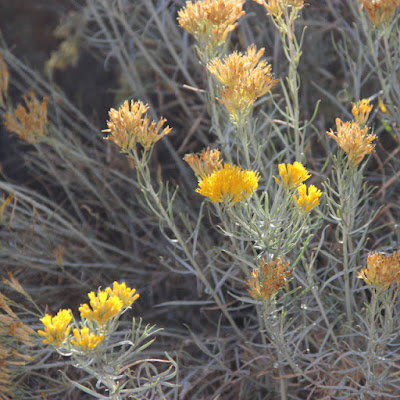
And finally, there were flowers. Rabbitbrush, Ericameria nauseosa (many still call it Chrysothamnus nauseosus), was blooming along many roadsides.


NOTES

(1) This is a metamorphic core complex. I visited two on my trip, and may try to put together a post about them, but they intimidate me. It seems they're poorly understood, even by experts.

(2) From Leonard Cohen's Suzanne, a song that will always be with me.

SOURCES

DeCourten, F. 2003. The Broken Land; adventures in Great Basin geology.

DeCourten, F, and Biggar, N. 2017. Roadside Geology of Nevada.

Tingley, JV, and others. 2010. A Geologic and Natural History Tour Through Nevada and Arizona Along U.S. Highway 93. NV Bureau of Mines & Geology.


Friday, July 27, 2018

Sunstones at Sunstone Knoll

Sunstone Knoll in western Utah’s Black Rock Desert (1); Bryant Olsen CC BY-NC 2.0
From the highway, Sunstone Knoll looked unimpressive—hardly worth stopping for. But I did stop. And after I explored it, imagined its fiery eruptions, and experienced its sparkles firsthand (including ten delightful minutes in the company of a small boy), I was impressed enough to take home a handful of mementos to fix the visit firmly in my memory.
Sunstone Knoll is one of many volcanic features in the Black Rock Desert near Fillmore, Utah (see recent post). Less than 100,000 years ago, it was an active cinder cone. Then it disappeared under the waters of Lake Bonneville, a huge ice age lake that covered much of northwest Utah. Erosion took its toll. Now just remnants of the cinder cone remain, and its lava flows are buried under Lake Bonneville sediments.
Remains of a compound cinder cone.
It’s neat to stand on Sunstone Knoll and ponder the dramatic ways in which the Earth changes—once a fiery cinder cone, then a lake for as far as the eye could see, and now a high desert. But history isn't the main attraction here. This is a rockhounding site. The basalt contains clear to pale yellow crystalline xenocrysts (inclusions) called sunstones.

While a true rockhound might feel the urge to put a rock hammer to basalt to find sunstones, it’s hardly necessary. Weathering and erosion have covered the ground around the knoll in gravel-sized rock fragments, and it doesn’t take long to spot sunstones flashing in the sunlight. Most of the larger ones (to 5 cm) have been carried off, but small ones are easy to find. In fact, they're unbelievably abundant. Many rockhounds have stopped here—the site is well-known and just off the highway. Even so, I quickly found a handful of sunstones.
Dime ~1.5 cm in diameter.

Sunstone Knoll is said to be a rockhounding site but properly speaking, sunstone is not a rock. It's a mineral—labradorite. Therefore this is my first mineralogical post. And like so many new things geological, it turned out to be more complicated than I expected. On the positive side, I learned quite a bit.

First a refresher:
“A mineral is a naturally occurring homogeneous solid with a definite (but not generally fixed) chemical composition and a highly ordered atomic arrangement, usually formed by an inorganic process (2)” Nelson 2013/2017
In other words, a mineral is a solid that’s not manmade, and is composed of a single kind of chemical compound, i.e., can be described with a chemical formula. Also, the atoms are orderly enough to form crystals. In contrast, a rock is an aggregate of various minerals (sometimes a single kind) or of rocks fragments or of shells (more here). As the USGS explains:
“A good way to think about it is if a chocolate chip cookie was a rock, then the flour, sugar, butter, chocolate chips are the minerals that make up that rock!”
Though probably not of general interest, I would be remiss if I didn’t provide the chemical formula for labradorite (source). It illustrates the “definite (but not generally fixed) chemical composition” of minerals described by Nelson, which means there are variable amounts of elements with atoms of similar size and charge:
(Na,Ca)(Al,Si)4O8 with Na (30-50%) and Ca (70-50%)
Mineral names usually end in “-ite”. They’re named after people most commonly (45%), followed by location of discovery (23%), chemical composition (14%) and various other things (source). As you probably guessed, labradorite was discovered in Labrador, Canada—specifically on the Isle of Paul in 1770 by a Moravian missionary (source).

When I searched Google for labradorite images, I found only a few that looked like the sunstones of Sunstone Knoll. Most labradorite specimens posted online exhibit labradorescence—beautiful flashy colors given off when light enters the specimen and is reflected from internal structure (rather than off the surface). But even though this phenomenon is named after labradorite, many labradorite specimens do not labradoresce—including Sunstone Knoll sunstones.
Labradorescing labradorite, from Madagascar; Géry Parent CC BY-ND 2.0
Sun shines through labradorite from Sunstone Knoll.
Labradorite usually is associated with mafic igneous rocks, commonly basalt and gabbro. At Sunstone Knoll, it occurs as inclusions in basalt. This basalt and that of other volcanoes nearby is tholeiitic in composition, unlike most volcanic fields in the Basin and Range Province. Johnsen et al. (2010) point out that tholeiitic magmatism is common in continental rift zones (as well as oceanic ridges), and suggest a rift might be developing here! Or the unusual composition may be due to the field's location between the extending Basin and Range Province and rotating Colorado Plateau (see previous post).
Labradorite xenocryst in basalt.

When I arrived at Sunstone Knoll, I first investigated one of the rocky crests, and found a sunstone in a chunk of basalt (above). Then I strolled around the base, where the ground was littered with small rock fragments washed down from outcrops above. Here my search was much more productive, especially after I discovered that if I walked at the proper angle to the sun, small flashes of light revealed the sunstones.
Sunstones seemed to be especially abundant in an abandoned anthill—collected preferentially? Arrows below mark a fraction of sunstones in the frame.
It was a lonely search. But then a minivan arrived and unloaded three generations of rockhounds. One of them—a boy maybe ten years old—ran toward me shouting: “Have you found any sunstones?! Where are they?! Show me!!” I explained my method and he went to work. After about ten minutes of collecting, he yelled to a man on the hill, “Grandpa, grandpa, they’re down here!!” But Grandpa knew Sunstone Knoll, and had a few tricks of his own. He returned from the crest with several very nice specimens in chunks of basalt.
View from Sunstone Knoll—all deep under water just 15,000 years ago!

Notes

(1) This is not the better-known Burning-Man Black Rock Desert of northwest Nevada.

(2) Traditionally minerals have been limited to compounds formed through inorganic processes, but mineralogists are reconsidering this rule: “… this eliminates a large number of minerals that are formed by living organisms, in particular many of the carbonate and phosphate minerals that make up the shells and bones of living organisms. Thus, a better definition appends "usually" to the formed by inorganic processes. The best definition, however, should probably make no restrictions on how the mineral forms.” (Nelson 2013)

Sources

Johnsen, RL, et al. 2010. Subalkaline volcanism in the Black Rock Desert and Markagunt Plateau volcanic fields, in Carney, SM, et al., eds., Geology of south-central Utah. Utah Geological Association Publication 39.

Millard County Travel. Day Trips in Millard County Utah—great guide to geo-sites and other things; available online (PDF, 17.4 MB) and at museums and agencies in the county.

Nelson, SA. 2013, updated 2017. Introduction and Symmetry Operations, Definition of a Mineral. Tulane University EENS 2110 Mineralogy (online lecture notes).


Friday, July 20, 2018

Volcanoes in Utah? How can that be?!

Black Rock Desert volcanic field in western Utah.
Volcanic eruptions have been big news lately, with graphic accounts from Hawaii, Bali and Guatemala, and fearsome stories of much greater destruction not so long ago. Yet most of us consider volcanism no threat to us personally. And we’re right. In the greater scheme of things, volcanoes are rare.
A volcano won’t erupt in your cornfield unless you farm in just the right place (Paricutín 1943).
Volcanoes are born when magma forces its way to the surface and becomes red-hot oozing lava, or a fiery fountain of ash and fractured rock, or a racing incandescent cloud that hugs the ground and incinerates everything in its path. But magmas don’t form just anywhere. They—and therefore volcanoes—require special circumstances.
Magma was once thought to flow from Hell, e.g. via Iceland’s Mount Hekla, the Gateway to Hell (source).
Magma is liquid rock, specifically silicate rocks (rich in SiO2). Therefore none of the layers of the Earth qualifies as a direct source of magma. Crust and mantle have the proper composition but are solid. The outer core is liquid, but the composition is wrong—iron and nickel. Therefore magmas must be melted mantle and crust (1). But what is the source of heat for melting? It’s here that debates rage.
Earth’s structure can be described by physical properties or by chemical composition; see (2). For this post, only “mantle” and “crust” are used, as is common in less technical discussions. Modified from Nelson 2015.
Global distribution of volcanoes coincides with certain types of plate boundaries (USGS via wikimedia).
A world map of active volcanoes reveals a suggestive pattern. Most line up along plate boundaries—where the shifting plates that make up the Earth’s surface collide, override, jostle and split in the dance of plate tectonics. This is an appealing pattern because several types of plate interactions could facilitate melting to form magma. Decompression melting probably occurs at divergent boundaries such as mid-oceanic ridges and rift valleys. At convergent boundaries (subduction zones), addition of water could lead to flux melting (Nelson 2015; OSU Volcano World).

But not all volcanoes conform to the pattern. Some erupt far from any plate boundary, and these intraplate volcanoes are difficult to explain.
Above and below, Ice Springs basalt flow in the Black Rock Desert, the most recent volcanic eruption in Utah. But why here?
Looks fresh enough to have erupted last year!
The Black Rock Desert volcanic field (3) is located about 120 miles south of Salt Lake City, Utah, well into the interior of the North American plate. It covers almost 2700 sq mi (7000 sq km), and includes shield volcanoes, cinder cones, lava domes, lava flows, maars and possibly a caldera. All are Quaternary in age, having erupted in the last 6 million years—most in the last 2.7 million. In other words, this field is young—and may still be active.

The field sits at the eastern edge of the Basin and Range Province, just west of the Colorado Plateau. Herein may lie an explanation for the intraplate volcanism. Though far from a plate boundary, this part of North America is hardly stable. Big changes are underway.
Quaternary volcanic fields are common in the Basin and Range Province and on the margins of the Colorado Plateau; modified from Valentine et al. 2017.
West of the Black Rock Desert, the Basin and Range Province has been expanding east-west for the last 30 million years, increasing the distance to the West Coast by 250 miles. Crustal extension may explain, at least in part, the Province’s thin crust; the mantle (asthenosphere) is only about 17-18 miles below the surface. And crustal thinning may explain (partly) the many Quaternary volcanic fields (map above).

Just east of the Black Rock Desert is the Colorado Plateau, which is very different from the Basin and Range Province. It’s a big chunk of crust that is thick (25-30 miles) and relatively undeformed. Volcanism is mostly restricted to the margins. Yet the Plateau is changing too. Precise GPS measurements show it's slowly rotating clockwise (4).

Most intriguing is the boundary between the extending Basin and Range Province and the rotating Colorado Plateau (5). It just happens to be lined with Quaternary volcanic fields, including the Black Rock Desert! Surely there’s a story here!!
Note volcanism along Colorado Plateau margins (Spence & Gross 1990).
In fact, there are multiple stories, all based to some degree on speculation. The earliest invoked a rising plume of hot mantle material over which the continent drifted, producing a line of progressively younger volcanism. While a “hotspot” model works well in Hawaii, it would be awkward to apply to the Colorado Plateau, requiring multiple hotspots and/or varied direction of movement.

But there may be no need to invoke mantle plumes; plate dynamics may be enough (6). Rotation and/or extension could be fracturing the crust sufficiently to create conduits for magma, especially where the crust is thinner (DeCorten 2003; see also Recent Volcanic Activity in Northern Arizona which includes discussion of western Utah). Or perhaps magma is rising through fractures in reactivated ancient crustal sutures (see my Jemez Lineament post). Ballmer et al. (2015) suggest that the difference in thickness between Basin and Range crust and that of the Colorado Plateau may affect mantle flow and cause decompression melting.
Looking north from Tabernacle Hill across basalt flows toward Pavant Butte, a large tuff cone.

Whatever the cause of magma generation, it seems likely that Black Rock Desert volcanism will continue. Little if anything has changed since the last eruptions, just 700 years ago. Basin and Range crust is still stretching, the Colorado Plateau is still rotating, and local mantle flow likely hasn’t changed much.
“There is really no more reason to believe that the epoch of basalt has closed in this region, than that it has barely begun; and it is certainly probable that the few centuries we can know by history and tradition, belong to one of the intervals of quiet, such as separate the more or less convulsive efforts of volcanoes; an interval to be terminated sooner or later by a renewal of activity.” Grove Karl Gilbert, 1875
Pavant Butte, from GK Gilbert’s 1890 Lake Bonneville monograph (USGS).
“Lava from valley of lower Sevier Utah” (Black Rock Desert; Gilbert 1875).

Utah’s Black Rock Desert lies just west of Interstate Highway 15 near Fillmore. Geo-tripping is convenient and fun. Most sites are on public land, and accessible by gravel and passable dirt roads. A wealth of geo-info makes the area especially interesting, ranging from the excellent Millard Country travel brochure to the scientific literature. In May I spent a week there, which wasn't nearly enough. More posts from the trip will be up soon.
"Volcanic District near Fillmore, Utah" (Gilbert 1890).

Notes

(1) Properly speaking, magma forms from partial melts—of mantle rock most often and occasionally crust.

(2) Two systems are used to describe Earth structure: physical properties and chemical composition. The resulting units are not equivalent. For example, based on physical properties, the outermost layer—the lithosphere—is solid brittle rock. But the lithosphere includes two different rock types based on chemistry—crust and uppermost mantle. Another example: the mantle is thought to be uniform chemically, but has three zones based on physical properties: the solid brittle part in the lithosphere, a solid but ductile asthenosphere directly below, and the solid mesosphere (source).

(3) This is not the Burning-Man Black Rock Desert of northwest Nevada.

(4) Estimated rotation rate for the main body of the Colorado Plateau is 0.103 ± 0.017° per Ma. Rates at the margins appear to be affected by Basin and Range extension (Kreemer et al. 2010).

(5) The western margin of the Colorado Plateau is sometimes called the Basin & Range Colorado Plateau Transition Zone (map courtesy Utah Geologic Survey).
(6) For more about the raging plume-ist vs. plate-ist debate, see Jack Share’s The Geologic Evolution of Iceland—specifically “A NEW GEOLOGICAL PARADIGM” about 2/3 of the way through the post.


Sources

Ballmer, MD, et al. 2015. Intraplate volcanism at the edges of the Colorado Plateau sustained by a combination of triggered edge-driven convection and shear-driven upwelling. Geochem. Geophys. Geosyst., 16: 366–379. doi:10.1002/ 2014GC005641.

DeCourten, FL. 2003.  The Broken Land: adventures in Great Basin geology.  Salt Lake City, Utah: University of Utah Press.

Gilbert, GK. 1875. Report upon the geology of portions of Nevada, Utah, California, and Arizona, examined in the years 1871 and 1872, in Wheeler, GM, Report upon United States geographical surveys west of the one hundredth meridian, v. 3, Washington DC:GPO. https://www.biodiversitylibrary.org/bibliography/49058

Gilbert, GK. 1890. Lake Bonneville. USGS Monograph 1. Washington DC:GPO. https://pubs.er.usgs.gov/publication/m1

Johnsen, RL, et al. 2010. Subalkaline volcanism in the Black Rock Desert and Markagunt Plateau volcanic fields, in Carney, SM, et al., eds., Geology of south-central Utah. Utah Geological Association Publication 39.

Kreemer, C, et al. 2010. Present‐day motion and deformation of the Colorado Plateau. Geophys. Res. Letters 37: L10311. doi:10.1029/2010GL043374

Nelson, SA. 2015. Structure of the Earth and the origin of magmas. Tulane University EENS 2120 Petrology (online lecture notes).

Spence, W, and Gross, RS. 1990. A tomographic glimpse of the upper mantle source of magmas of the Jemez Lineament, New Mexico. Journal of Geophysical Research 95 B7:10,829-10,849.

Valentine, GA, et al. 2017. Lunar Crater volcanic field (Reveille and Pancake Ranges, Basin and Range Province, Nevada, USA) Geosphere13: 391-438. https://doi.org/10.1130/GES01428.

Volcano Hotspot. 2018-01-09. Recent volcanic activity in SW Utah.