|
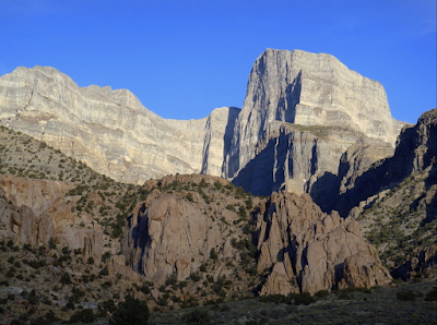
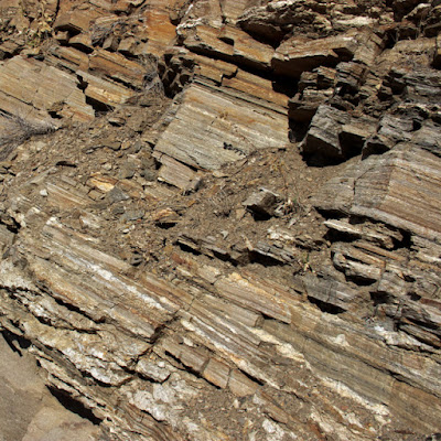
| Deformed lower crustal rocks high in the Ruby Mountains. How did this happen?! |
In August of 1868, Clarence King's Survey of the Fortieth Parallel arrived in the East Humboldt Range in northeastern Nevada. The focus was geology. In fact, King was one of three geologists on board, the others being Arnold Hague and SF Emmons. They found the East Humboldts spectacular—"the most prominent uplift lying between the Sierra Nevada of California ... and the Wahsatch of Utah ... with many rugged summits reaching over 10,000 feet above sea-level" (Hague & Emmons 1877).
In the 150 years since, much has changed. The single range is now two: the East Humboldt Range to the north and the Ruby Mountains to the south, separated by today's Secret Pass (formerly Sacred Pass). A pass in the southern Rubies that used to honor explorer John Frémont is now Harrison Pass. It was here that the geologists discovered a dramatic change. To the south were thick beds of sediments deposited in a Paleozoic sea. To the north was a huge mass of seriously deformed rock.
King took it upon himself to study the area north of Frémont's Pass. He assigned the deformed rocks to the Archaean, which at that time included all Earth history before the Cambrian. King concluded these rocks had been an island in a Paleozoic sea. This was a reasonable hypothesis, not at all out of line with current thinking. But that too has changed.
 |
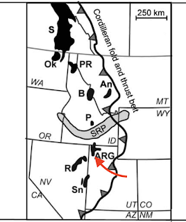
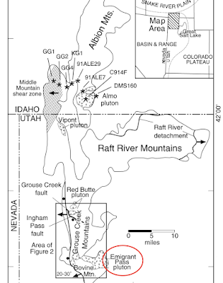
| Ruby Mountains and vicinity; points of interest in red (after Snoke et al. 1997). |
A year earlier, 25-year-old Clarence King—young, bright, and ambitious—had persuaded Congress to fund a
Geological Exploration of the Fortieth Parallel, which he would lead. His assignment was broadly defined—"a geological and topographical exploration of the territory between the Rocky Mountains and the Sierra Nevada ...".
King must have been ecstatic. This was a region poorly known geologically and ripe for discovery. He and his crew spent seven seasons in the field. The result was a large atlas of topographic and geologic maps, and seven reports, published from 1877 to 1880.
Volume II, Descriptive Geology, was the first (Hague & Emmons 1877). Arnold Hague wrote the section about the East Humboldt Range. He began with the area south of Frémont's (Harrison) Pass, in today's southern Ruby Mountains. Here were very thick beds of Paleozoic rocks, with limestone conformably overlying quartzite. "The quartzites appear a little calcareous and the limestones somewhat siliceous, but the transition is made by a rapid passage from one to the other."
North of Frémont's Pass "a change takes place in the rock ...", noted Hague laconically. In fact it was a dramatic change. The thick beds of Paleozoic sediments were replaced with deformed metamorphic rocks. Relying on King's notes, Hague described Archaean quartzites and crystalline schists extending from the crest all the way down to the valley to the west, where they disappeared under Pliocene sedimentary rocks. This situation continued to the northern end of the range. Aside from one or two small remnants, the Paleozoic limestone was gone.
 |
| Archaean quartzite, [East] Humboldt Range, Nevada (King 1878). |
The next report published was Volume I,
Systematic Geology (King 1878), an ambitious tome. Much of it was what we call historical geology—a challenging subject then. Some very basic geology had yet to be figured out, for example the composition of the Earth, and the origin of mountains.
Contractionists argued the Earth was a solid body that was cooling and contracting. Wrinkling of the shrinking surface created mountains. Others argued that the Earth's interior was molten; convection currents in the molten interior created volcanoes and other mountains. Clarence King leaned toward the latter hypothesis, but addressed it only briefly in his report. "I prefer to build no farther till the underlying physics are worked out ... leaving their minute discussion to a day in the near future when it can be done on a firmer physical foundation" (italics mine).
What was King thinking when he wrote "near future"? Years? Decades? In fact, it would be almost a century before geologists came up with plate tectonics, and another twenty years passed before "metamorphic core complex" was added to their vocabulary.
 |
| East Humboldt Range (Hague & Emmons 1877). Click to view geologist on an Archean "island". |
King took it upon himself to discuss "the configuration and general relief of the area of the Fortieth Parallel at the close of Archaean time". It was here that he revealed his thinking about the creation of today's mountains. "Over the whole distance from the Rocky Mountains to western Nevada, in almost every prominent range, the contact may be observed between the Archaean and the Palaeozoic series. At times, Archaean summits are seen to rise above the level of the deposition of the Upper Carboniferous ..." King concluded the ancient rocks at the crests of today's mountain ranges were once part of Archaean ranges. Then the high peaks became islands in a Paleozoic sea.
The East Humboldt Range was a fine example: "The Humboldt was one of the greater Archaean ranges, and the subsequent Palaeozoic rocks are deposited unconformably, abutting against its steeply inclined flanks, leaving unsubmerged insular Archaean summits."
In the Archaean section of Systematic Geology, King included a map of Archaean rocks with a cross section. The excerpt below shows "Archaean bottom of the ocean in which Paleozoic sediments were deposited ...". Note that the high peaks of the East Humboldt Range were above sea level during deposition of the Wahsatch limestone.
 |
| From King 1878, click to view. |
Today the Ruby Mountains/East Humboldt Range is considered a metamorphic core complex (MCC; also called core complex). MCCs are giant complicated structures, and it wasn't until the early 1980s that someone came up with a generally acceptable hypothesis.
 |
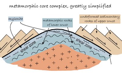
| Based on Peterson & Buddington 2014, DeCourten & Biggar 2017. |
As shown above, MCCs include a dome of lower crustal metamorphic rock exposed to some extent at the surface. Above it are unmetamorphosed sedimentary rocks of the upper crust. These have been faulted, fractured, detached, and transported away from the crest of the dome. In other words, today's geologists think metamorphic rocks in the Rubies and East Humboldts came not from Archaean high peaks but from deep below the surface. This is very cool! It's not often we get to look at rocks metamorphosed by the great pressures and high temperatures of the lower crust.
The highly deformed metamorphic rocks and the undeformed sedimentary rocks are separated by a low-angle detachment fault. At the contact, the metamorphic rocks have been mylonized—highly deformed by very large shear strain. I would think giant moving chunks of rock could do just that, especially if the lower crustal rocks were a bit ductile from all the heat down there.
 |
| Mylonized (seriously scrunched) rock, East Humboldt Range. NV Highway 229 west of Secret Pass. |
I first learned about MCCs on trip across the Great Basin about 15 years ago. In Broken Land (2003), Frank DeCourten described how it had taken him several decades to get up the nerve to visit one. "The complexity of these structures struck me as virtually incomprehensible." I felt the same way, but fortunately I had several guidebooks along on my trip last October.
MCCs are intimidating in part because they are so huge, too big to see. We can only glimpse bits of the various parts here and there. The best view of a MCC on my trip was not in the Rubies but the northern Snake Range. In the photo below, the very thin rock band is mylonite, marking the low angle detachment fault. Outcrops above it are fractured Paleozoic sedimentary rocks that moved eastward.
 |
| Snake Range north of US Highway 50 near turnoff to Baker, NV. |
On the west side of the Ruby Mountains, the walls of Lamoille Canyon provide views of contorted metamorphic rocks of the lower crust, which domed up with formation of the MCC.
 |
| A glimpse of the interior of the Earth! |
The upper canyon features a pegmatite dike–sill complex intruded into gneiss and marble.

 |
| Pegmatite in gneiss along trail to Lamoille Lake. |
King thought the metamorphic rocks high in the East Humboldt Range were Archaean, equivalent to Precambrian today. He wrote, "... we have no conclusive proof of metamorphism of Palaeozoic strata to so extreme a point as to endanger a mistake between the resultant rocks and those of Archaean age." But King lived before the time of radiometric dating. Turns out most of the metamorphic rocks high in the Rubies and East Humboldts are indeed Paleozoic; only a few are older (Proterozoic).
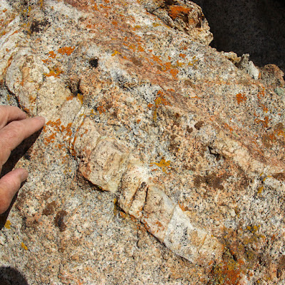
In road cuts along Highway 229 in Secret Canyon, geogeeks can experience mylonite up close. In the photos below, the rocks midslope are Mississippian and Pennsylvanian sedimentary formations "dismembered" by serious deformation.
I collected several distinctive mementos to add to my collection at home.
Now the really hard question: What created the Ruby/East Humboldt MCC? Maybe it was extension, stretching and thinning of the crust. This is a reasonable hypothesis given that North America from central Utah to eastern California has been expanding for c. 30 million years—enough to double the distance between Reno and Salt Lake City (DeCourten & Biggar 2017). But regional extension isn't enough. Extension in the Ruby/East Humboldt MCC is extreme. Faulted and fractured Paleozoic sedimentary rocks moved as much 50 km in places. Also, MCC formation started well before regional extension.
There are other questions. How were huge chunks of rock set in motion and transported so far if the detachment fault is low angle? And why did all this happen? Did extreme extension allow the rise of lower crustal rocks, formerly buried 20 km deep or more (i.e., isostasy in response to thinning)? Or did anomalous mantle convection cause upwarp of deformed crustal rocks? MCCs seem so strange—are they real?
Maybe today's metamorphic core complexes will turn out to be historical curiosities, like Clarence King's island theory of 150 years ago. King acknowledged his hypothesis was largely speculative. But he wasn't much troubled, being satisfied to contribute "whatever value this Report may possess, either as a permanent contribution to knowledge or as a stepping-stone worthy to be built into the great stairway of science ..."
 |
| How high have we climbed on the great stairway of science? |
Bartlett, RA. 1962. Great surveys of the American West. U. Oklahoma Press.
DeCourten, F, and Biggar, N. 2017. Roadside Geology of Nevada. Mountain Press.
Hague, A, and Emmons, SF. 1877. Descriptive geology. Report of the geological exploration of the fortieth parallel, v. I. GPO.
King, C. 1878. Systematic geology. Report of the geological exploration of the fortieth parallel, v. II. GPO.
Maley, TS. 2017. Metamorphic core complexes and related features, in Idaho Geology, 2nd ed.
PDF.
Peterson, J., and Buddington, A. 2014. A geological study of the McKenzie Conservation Area, Spokane County, Washington. Conference Paper.
Snoke, AW, et al. 1997. The Grand Tour of the Ruby-East Humboldt Metamorphic Core Complex, Northeastern Nevada: Part 1-Introduction & Road Log. Geology Faculty Publications. 39.