 |
| First, the Weather Report. |
 |
| Rock huggers. |

 |
| Limber pines, Pinus flexilis (named for tough flexible branchlets). |
 |
| Trees grow taller at the top, not from the base (a common misconception). |

|
| First, the Weather Report. |
|
| Rock huggers. |
|
| Limber pines, Pinus flexilis (named for tough flexible branchlets). |
|
| Trees grow taller at the top, not from the base (a common misconception). |
 |
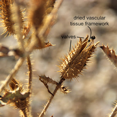
| Prickly poppy, Argemone sp. |
Prickly poppies are common roadside plants, with large showy white flowers. After the petals fall, and the plant turns brown and dry, the interesting structure of the capsules becomes apparent. A prickly poppy capsule opens by splitting from the apex down about ⅓ of its length, producing segments called valves. The valves spread to reveal a framework of dried vascular tissue, joined at the top by the persistent style and stigma (female flower parts).
 |
| Prickly indeed! |
 |
| Wild buckwheat, Eriogonum sp. The diffuse inflorescence is roughly 30 cm across. |

 |
| Involucres are about 2.5 mm long. |

 |
| Trailer Park Rock, part of the Harrison Pass pluton. |
 |
| Ruby Mountains in northeast Nevada; note Harrison Pass (modified from Snoke et al.1997). |
Trailer Park Rock started as molten magma far below the surface, in a place very different from the Earth we know. This is where the familiar lava and ash of volcanos originate as well, so it be must super hot. Could it be Hell itself?! Let's descend to the Center of the Earth. Maybe we'll find out.
Downward
 |
| Dante at the Gates of Hell on Easter Sunday, 1300 (Doré 1890). |
Here's a diagram of the territory ahead—a refresher for people like me who find classification of the Earth's interior complicated. Note that there are two classifications—one based on chemical composition, and one based on physical properties. This can be confusing, especially for the outer layers.
 |
| Two classifications of the Earth's interior—chemical composition (right) and physical properties (left) (modified from Nelson 2015). |
Since we're on land far from any ocean, we pass through continental crust—low density light-colored "felsic" rocks high in silica (2). This seems like an excellent magma source, as the Harrison Pluton is largely felsic. In contrast, the other layer of the lithosphere, the uppermost mantle, is peridotite, a high density dark "ultramafic" rock with much less silica and more iron and magnesium. But neither layer is liquid, so we will keep searching.
Below the lithosphere lies the asthenosphere, also part of the mantle. It's solid but soft enough to flow (ductile). It's thought that this flow drives plate tectonics—that lithospheric plates are rafted about on currents of sorts in the asthenosphere. However, it too is made of ultramafic peridotite, so we continue on.
Next we pass through the mesosphere, where the mantle is noticeably more rigid and composition is uncertain. Then, finally, we arrive at a truly liquid place, the outer core. But the composition is all wrong—mostly iron with a bit of nickel. As we approach the inner core, we see through sinister swirling shadows that it's solid rock. Probably best to turn back here.
 |
| Confronting denizens of the dolorous world (modified from Doré 1890). |
But before we ascend, we must ask, "Why we didn't we find what we were seeking?" There has to be magma somewhere! Were we blinded by our expectations? Perhaps solid rock is fine if it can be melted. Maybe peridotite can somehow be turned into granitic rocks.
In fact, we passed suitable rocks near the beginning of our trip, in the lithosphere (crust + uppermost mantle). As my guides explain, melted lithosphere is likely the source of most magma (3). But what heat source can melt solid rock? Actually, rock doesn't have to be heated until it melts. Instead, its melting temperature can be lowered, commonly by the introduction of water or carbon dioxide (4).
While it's generally agreed that plutons originate as melted lithosphere, the question of which layer—crust or uppermost mantle—is debated. For granitic rocks such as Trailer Park Rock, continental crust is closer in composition. But geologists have learned that peridotite also can be a source of granitic rock. Molten peridotite can become more siliceous as it melts or as it rises or both, the iron and magnesium dropping out (e.g., Meldahl 2013; Nelson 2012).
Once back in the lithosphere, we wander around until we find some molten rock—magma—and follow it upward. It squeezes through fractures, melts adjacent rock, and engulfs large chunks of crust (stoping). It will ascend as long as it can, fueling volcanos if it reaches the surface. But our magma cools and becomes too viscous to move. It solidifies underground, forming a pluton. Because this could take a million years or more, we return to the surface.
 |
| Emerging from the Underworld (Doré 1890). |
 |
| California's Sierra Nevada is a gigantic batholith—an agglomeration of many plutons. |
 |
| Sherman batholith in the Laramie Mountains (Wyoming) is thought to be derived from mafic mantle rocks. |
Back to Harrison Pass
Obviously some plutons don't stop below the surface. After a hiatus underground, they rise again, this time carried by the crust around them. After enough uplift and erosion, they are revealed. The Harrison Pass pluton has been rising with uplift of the Ruby Mountains, which started after the pluton formed (Barnes et al. 2001) and continues today.

The igneous rock exposed at Harrison Pass is granodiorite, a granitic rock felsic to intermediate in composition, perhaps reflecting mixed origins—continental crust and mantle. It's one of the older rock units in the pluton, emplaced early on.

 |
| A seriously cropped photo, shot from across the road. |
(1) "Granitic" is a category of rocks; granite is one member of the group.
(2) Plutonic igneous rocks often are classified based on silica content. In decreasing order, types include felsic, intermediate, mafic, ultramafic, and gradations in between (source). The mantle is ultramafic; the crust includes both felsic rocks (continental crust) and mafic rocks (oceanic crust).
(3) One possible exception is volcanic hot spots, where thin plumes of magma are thought to rise from deeper in the mantle (Nelson 2015).
(4) This is flux melting, in which volatiles such as water and carbon dioxide are introduced into hot rock at depth, lowering the melting temperature. It's thought to be common in but not restricted to areas of plate subduction (e.g., Nelson 2015, Johnson et al. 2021).
SOURCES
Thanks to Mike the Rock Guy for his continued help and patience.
Barnes, CG, et al. 1997. Grand Tour-Part 4: Geology and geochemistry of the Harrison Pass pluton, central Ruby Mountains, Nevada (in Snoke et al. 1997, 283-292). Available here.
Barnes, CG, et al. 2001. Petrology and geochemistry of the Harrison Pass pluton. J. Petrology 42:901-929.
DeCourten, F. 2003. The Broken Land; adventures in Great Basin geology.
DeCourten, F, and Biggar, N. 2017. Roadside Geology of Nevada.
McGrew, AJ, and Snoke, AW. 2015. Geologic map of the Welcome Quadrangle and an adjacent part of the Wells Quadrangle, Elko County, Nevada. Text and references accompanying Nevada Bureau of Mines and Geology Map 184. Available here.
Meldahl, KH. 2013. Rough-Hewn Land, a geologic journey from California to the Rocky Mountains. U. Calif. Press.
Nelson, SA. Lecture Notes (various classes). Dept. of Earth & Environmental Sciences, Tulane University. Accessed 2017.
Snoke, AW, et al. 1997. The Grand Tour of the Ruby-East Humboldt Metamorphic Core Complex, Northeastern Nevada: Part 1-Introduction & Road Log. Geology Faculty Publications. 39. Available here.
 |
| Flash the maple is thick with dried samaras. |
 |
| Spike the hawthorn still sports a bit of red and green. |
~🍂~
Though the beech is goldenI cannot stand beside itmute, but must say"It is golden," while the leavesstir and fall with a soundthat is not a name.It is in the silencethat my hope is, and my aim....
The Silence by Wendell Berry

This is my brief contribution to November's gathering of Treefollowers. Consider joining us—as you can see, it doesn't have to be a lot of work. Photos would have been enough, but like Berry, I "must say".
 |
| Petrophytum caespitosum mat on limestone. Dark spots are shadows cast by flower clusters. |
It was first collected by the great pioneering botanist Thomas Nuttall, probably in 1836, probably somewhere in the southeast quarter of Wyoming. His specimen—two small fragments, each with a flowering stalk—now resides at Harvard University (HUH; closeup below). Nuttall's yellowed handwritten label in the corner is terse: "Spiraea (Petrophyta. Caespitosa. Platte [River] sources." We shouldn't blame him. The expedition was on the move; time and space were limited. Large specimens and detailed location information were out of the question. Furthermore, it was an exploratory expedition. The country was still being figured out.
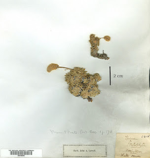 |
| Spiraea caespitosa collected by Thomas Nuttall. (HUH; lower right corner of herbarium sheet; scale line added). |
The next known collection was made by William Whitman Bailey, botanist with Clarence King's Geological Exploration of the 40th Parallel. He found it in September of 1867, in the West Humboldt Mountains in western Nevada. His collection also resides at Harvard. But Bailey went further. That winter, he made a sketch of the rockmat eponymously sprawling across rock. It was added to the herbarium sheet, showing what can't be seen in a dried pressed specimen.
 |
| WW Bailey's Spiraea caespitosa (one of six specimens, from various collectors, on a single sheet; HUH). |
 |
| Bailey's sketch of Spiraea caespitosa in the West Humboldt Mountains (HUH). |
From San Francisco, Watson took the train as far east as it went, and then walked across the Sierra Nevada to King's survey camp. After presenting a letter of introduction from a mutual friend, he begged for a job. He would help in any way he could. King hired him as an assistant topographer and general camp helper, for "nominal" pay—basically a "volunteer" (Brewer 1900).
But the gods soon smiled on Sereno Watson. Bailey, the official botanist, began to have health problems, so Watson became his assistant. When Bailey quit in early 1868, Watson was appointed expedition botanist, with a salary. It was the beginning of a successful and very satisfying life collecting and studying plants (3).
In early May of 1868, the expedition "took the field again and worked eastward from the Washoe through the Trinity, West Humboldt, Havallah, and the several other mountain ranges to Ruby River [possibly the Franklin River in the Ruby Valley], and from there the East Humboldt Mountains were explored" (Brewer 1900).
It was in the East Humboldt Mountains that Watson collected Petrophytum caespitosum. At that time, the East Humboldt range included the Ruby Mountains, which is where I saw it. Was the ghost of Sereno Watson nearby?
In his catalogue of collections, Watson provided a specific location: "Cliffs above Camp Ruby 7,000 ft." On my visit, I camped at the foot of the Ruby Mountains just 7.5 mi north of old Camp Ruby (also called Fort Ruby). I found the rockmat in a canyon immediately west. Sereno and I definitely were in the same area! And though I don't believe in ghosts, I do see them on occasion.
 |
| Petrophytum caespitosum at base of limestone cliff, east side Ruby Mountains; October 2021. |

 |
| Stems rise from clusters of leaves 3–12 mm long. |
 |
| Inflorescences can be branched, but usually are simple cylindrical racemes. |
 |
| Petrophytum caespitosum in a crack high up on the cliff (tip of arrow). |
 |
| "The top of this two foot long plant is attached to the rock wall; the rest of the plant swings gently with any breeze." Photo ©Al Schneider, http://www.swcoloradowildflowers.com |
 |
| Petrophytum caespitosum, with butterfly; Wasatch Range, Utah. Photo by Andrey Zharkikh. |
(1) In Nuttall's day, "alpine" did not necessarily mean the highest elevations, above treeline. It was sometimes used for lower montane sites with no trees—a common situation in the arid American West.
(2) The genus is sometimes called Petrophyton, said to be an "orthographic variant (misspelling)".
(3) Among other things, Sereno Watson became Curator of Gray Herbarium at Harvard in 1888, a position he held until his death in 1892 (Coulter 1892).
 |
| Sereno Watson, a "thorough and painstaking" botanist, working at Gray Herbarium (Coulter 1892). |
SOURCES
Once again, I'm immensely grateful to the Biodiversity Heritage Library (BHL) for providing such easy access to original literature!
Brewer, WH 1903. Biographical memoir of Sereno Watson, 1820-1892. National Academy of Sciences. PDF
Coulter, JM. 1892. Sereno Watson. Bot. Gaz. 17:137–141, Plates VI, VII. Available online courtesy BHL.
Nuttall, T. 1840. Spiraea cespitosa in Torrey, J, and Gray, A. Flora of North America v. 1, 417-418, Available online courtesy BHL.
Rydberg, PA. 1900. Catalogue of the flora of Montana and the Yellowstone National Park, vol. 1:206–207. Available online courtesy BHL.
Watson, S. Catalogue of botanical collections made in Nevada and Utah, in 1867-9. Harvard University Botany Libraries. Available online courtesy BHL.
Williams, RL. 2003. A Region of Astonishing Beauty: The botanical exploration of the Rocky Mountains. Roberts Rinehart.

Formation on a passive continental margin. Roughly 500 million years ago, much of eastern Nevada was a warm shallow ocean where sand, mud, and limey muck accumulated. With pressure, cementation, and enough time, the sediments became rock—thick layers of sandstone, shale, and limestone. This went on for hundreds of millions of years. Then Nevada's idyllic coastal setting came to an end.
Deformation caused by uplift and intrusion. By about 250 million years ago, the sea had disappeared. It was replaced with land pushed up and contorted due to the jostling of lithospheric plates far to the west. This also caused production and rise of magma, much of which cooled and hardened before reaching the surface. When magma was intruded into the old sedimentary rock layers, they were deformed and often metamorphosed (one reason there are so many productive mines in Nevada).
Deformation due to continental extension. Currently much of western North America is stretching, as it has been for maybe 30 or 40 million years. Nevada is about twice as wide as it was thirty million years ago! The old marine sedimentary rocks have been disturbed once again—uplifted and often tilted. As a result, mountains have risen and intervening land has sunk, forming the Basin and Range Province.
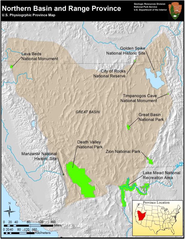
 |
| Northern Basin and Range Province (NPS). The many more-or-less parallel mountain ranges looked like "an army of caterpillars marching toward Mexico" to pioneering geologist Clarence Dutton. |
With my limited background, I found this type of road cut cryptic, even with a guidebook. No matter, I poked around just the same. That's how I came upon this treasure amid the garbage and the flowers (2).
 |
| One of many beer cans for scale. |


The rock exposed here is mostly old limestone that formed when eastern Nevada was a shallow sea. Since then it has been greatly altered. Intruded magma probably played a role, for there is mineralization nearby (copper, silver, lead, zinc, and gold). The limestone also has been subjected to extreme extension, fracturing into huge chunks that moved for miles. In the process, the rock was broken into angular fragments, which were then cemented back into rock in various ways to form limestone breccia ("breccia" is Italian for rubble or rubbish).
 |
| Calcite veins in fractured limestone. |
 |
| Gypsum crystals in the Naica cave, a giant geode. Alexander Van Driessche photo (source). |


 |
| Fragments of limestone with quartz veins in a matrix of ... ?? |
 |
| Red coloration was common, due to iron oxide according to the guideboook. |
 |
| Another puzzling but beautiful spot, with calcite, iron oxide, and an unknown rock. |
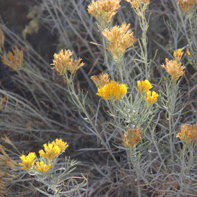
And finally, there were flowers. Rabbitbrush, Ericameria nauseosa (many still call it Chrysothamnus nauseosus), was blooming along many roadsides.

(1) This is a metamorphic core complex. I visited two on my trip, and may try to put together a post about them, but they intimidate me. It seems they're poorly understood, even by experts.
(2) From Leonard Cohen's Suzanne, a song that will always be with me.
SOURCES
DeCourten, F. 2003. The Broken Land; adventures in Great Basin geology.
DeCourten, F, and Biggar, N. 2017. Roadside Geology of Nevada.
Tingley, JV, and others. 2010. A Geologic and Natural History Tour Through Nevada and Arizona Along U.S. Highway 93. NV Bureau of Mines & Geology.