Showing posts with label Frémont (John Charles). Show all posts

Saturday, March 27, 2021

Mapping the Laramie Plains I: in pursuit of the 3rd dimension

"... almost every hill and cañon can be determined at a glance!" From first Laramie, Wyoming Sheet (USGS 1895; public domain).

In the spring of 1893, Albany County Surveyor W.O. Owen received a set of preliminary maps from the US Geological Survey for review. Owen had known what to expect, but the others who saw them were surprised. "The maps are of a very interesting character ...", wrote a reporter for the Laramie Boomerang, "almost every hill and cañon can be determined at a glance!"

Indeed, the new map was astonishing—mountains and depressions around Laramie had been clearly mapped using squiggly lines! But this achievement was long in coming. For millennia, mappers had struggled to show topographical relief, to capture the third dimension on a two-dimensional sheet of paper.

Line + cones = valley
From Amennakhte's map for pharaoh Ramesses IV. Public domain.
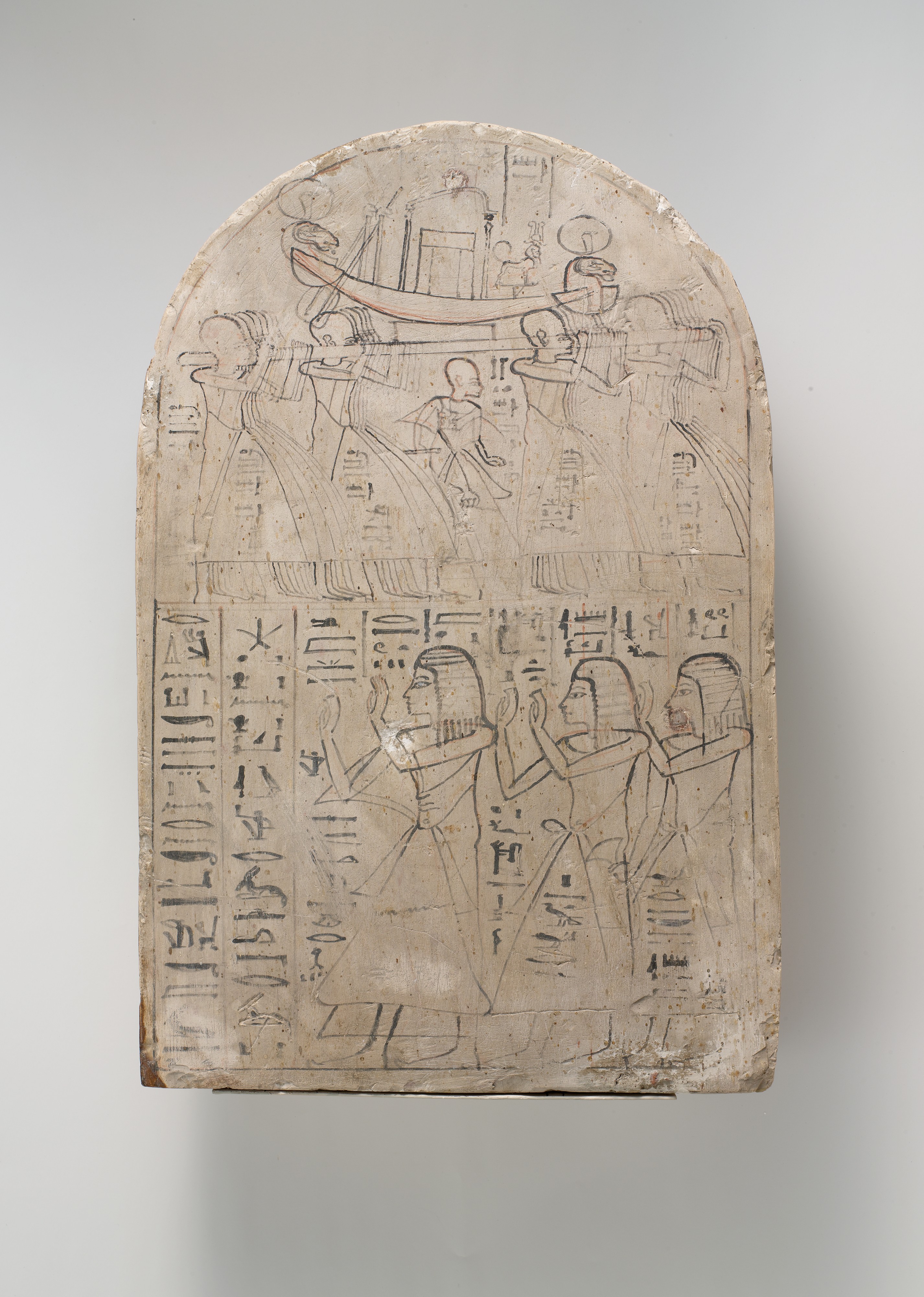
In 1160 B.C. Scribe-of-the-Tomb Amennakhte made a map for Egyptian pharaoh Ramesses IV, who was planning a trip to quarry sandstone suitable for statues. On papyrus, he drew a broad winding line with bumpy cones lying flat on either side. With a bit of imagination, we see this is a valley lined with hills.

Amennakhte's hills look terribly crude to our eyes. Yet they aren't all that different from those appearing on maps for the next two millennia. As late as the 16th century, during early exploration of North America, mountains were shown as oversized cones, though sometimes shaded to suggest depth. Often their locations were based on distant views from sea, or rumors.
Leftmost figure is "Royal Scribe of the Place of Truth" Amennakhte. Carving on limestone, ca. 1184–1070 BC. Metropolitan Museum of Art; public domain.

Lewis & Clark map new territory

The next centuries brought significant improvements in surveying and mapping, fortunately. In the early 1800s, the young United States was in desperate need of good maps. The Louisiana Purchase had doubled the country's size. Little was known about the new territory—not even its size, nor how to traverse it.

In May 1804, the Corps of Discovery Expedition, led by Meriwether Lewis and William Clark, headed up the Missouri River in search of a route to the Pacific Ocean. In preparation for the trip, Lewis was trained in celestial navigation. President Thomas Jefferson personally provided instructions for mapping:
"... you will take observations of latitude & longitude, at all remarkable points on the river [e.g., rapids, river mouths, islands]. The interesting points of the portage between the heads of the Missouri, & of the water offering the best communication with the Pacific ocean, should also be fixed by observation ..." [Jefferson assumed they could reach a west-flowing river by carrying their boats overland.] "Your observations are to be taken with great pains & accuracy, to be entered distinctly & intelligibly for others as well as yourself, to comprehend all the elements necessary, with the aid of the usual tables, to fix the latitude and longitude of the places ..."

Lewis and Clark faithfully executed Jefferson's instructions, for three years, four months, ten days and 8000 miles.

William Clark, explorer, soldier, Indian agent, territorial governor & cartographer; portrait by Charles Peale 1810. Public domain.
Clark's map reveals a multitude of mountains

William Clark took on the job of mapmaker. In addition to the Expedition observations, he used information from explorers, trappers, natives, and earlier maps to include areas not covered by the expedition. His first map showed the Corps’ route in great detail and was necessarily huge—50+ large sheets. He then produced a single map 52 inches long and 31 inches wide, engraved and published in 1814: “A Map of Lewis and Clark's Track, Across the Western Portion of North America ...”

Among the discoveries visible on Clark's map is the structure of the Rocky Mountains. They are not a single long ridge as previously thought, but a complex system of mountain ranges and foothills. In fact, after reaching the headwaters of the Missouri, the Corps of Discovery had to travel for weeks on horseback and foot to reach west-flowing waters. A portage across the Rockies was out of the question (click on image below).
Lewis & Clark's Track. Courtesy David Rumsey Map Collection (available in high resolution).
If you click on these images, you can see that mountains were drawn with hachures—short parallel lines looking something like eyelashes. Length and curvature gave a sense of height and steepness. Hachures were denser and darker on east and south slopes of ranges, suggesting a third dimension.

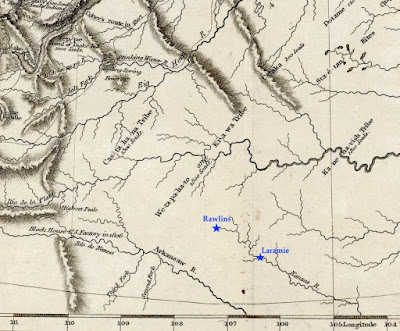
Clark's map was mostly accurate by the standards of the day. But there is a glaring error in the southern part. The Laramie Plains and surrounding mountains are missing! Little was known about the territory that would become southern Wyoming, so future Colorado and Kansas were moved north to fill the gap. This is why the Kanzas [sic] River was shown flowing where Rawlins and Laramie are today.

Today's southern Wyoming, from Lewis & Clark's Track. The Arkansas and Kansas Rivers were mapped hundreds of miles northeast of their true location, putting them in the vicinity of modern-day Rawlins and Laramie (added). Courtesy David Rumsey Map Collection.

The Pathfinder puts the Laramie Plains on the map

John C. Frémont "on the Rocky Mountains"; public domain.

In July 1843, a small contingent of the US Army Corps of Topographical Engineers climbed out of the canyon of the Cache-à-la-Poudre River, where they had hoped to find a route over the Rocky Mountains. Instead, they crossed the broad divide to the north.

In command was a young ambitious lieutenant—John Charles Frémont, the Pathfinder. This was the second of five expeditions he would lead through the American West, each time making significant contributions to geographical knowledge. He also would be court-martialed, lose a presidential election, squander large sums of money in mining schemes, and die in poverty. But all that was far in the future on that lovely summer day when the Laramie Plains came into view.

"The weather was pleasant and cool, we were disturbed by neither musquitoes [sic] nor flies; and the country was certainly extremely beautiful," Frémont would write in his report. "The slopes and broad ravines were absolutely covered with fields of flowers of the most exquisitely beautiful colors. ... As we emerged on a small tributary of the Laramie river, coming in sight of its principal stream, the flora became perfectly magnificent; and we congratulated ourselves, as we rode along our pleasant road, that we had substituted this for the uninteresting country between Laramie hills and the Sweet Water valley."

Challenges: stones, sagebrush, longitude

That evening, they camped on the Main Fork of the Laramie River, where Frémont took astronomical readings to determine latitude and longitude. While latitude seems to have been accurate, his calculation of longitude put them too far west, in the Medicine Bow Mountains near Lake Owen according to Google Earth. But that's not surprising. Estimating longitude was difficult, requiring careful tracking of stars with a precision telescope and a chronometer that kept steady time, or at least lost time at a steady rate.

For three days the party traveled northwest along the Medicine Bow mountain [sic]. The going was easy at first, but near the mountain they were slowed by large round stones in the soil. Equally difficult were ridges "made extremely rough by the stiff tough bushes of artemisia tridentata, in this country commonly called sage" [as it is today].

On August 2, they camped on the Medicine Bow River near "an isolated mountain called the Medicine Butte [Elk Mountain], which appeared to be about 1,800 feet above the plain, from which it rises abruptly, and was still white nearly to its base with a great quantity of snow". Frémont made more astronomical observations, this time including "an immersion [eclipse] of the first satellite of Jupiter." Even so, the calculated longitude again put them too far west.

After passing south of Elk Mountain, the party dropped down to the North Platte River, followed it to the Sweetwater, and continued on to California and Oregon. They would return home in August 1844, after about 15 months and 10,000 miles of travel.

A "meagre and skeleton" but valuable map (Frémont & Preuss 1845). High resolution version here, courtesy David Rumsey Map Collection. 

Dramatic report, spectacular map

Frémont wrote a colorful report about his adventures, with the help of his wife, Jesse, whose father—the powerful Senator Thomas Hart Benton—had secured funding for the expedition. Ten thousand copies were published the following year, to rave reviews. Included was the spectacular “Map Of An Exploring Expedition To The Rocky Mountains” measuring 52 x 30 inches, and stretching from the Missouri River west to the Pacific Ocean and from Los Angeles north to Mt. St. Helens.

However, much of the map was blank—to Frémont's credit. In a Notice to the Reader, he explained: "The map may have a meagre and skeleton appearance to the general eye, but is expected to be more valuable to science on that account, being wholly founded upon positive data and actual operations in the field." Indeed, the map is now considered a milestone, having set a new standard of cartographic accuracy for the American West.

The mapmaker was Charles Preuss, a trained surveyor and topographic artist from Prussia. He would accompany Frémont on three expeditions, making "continuous topographical sketches of the regions through which we passed, and which were never interrupted by any extremity of fatigue or privation" (Frémont's words). The large beautiful maps secured his reputation as a great cartographer.

Cartographer Charles Preuss, date unknown. Source (without attribution).

Laramie Plains up close

In the 30 years since publication of the Lewis and Clark map, techniques for representing relief hadn't changed all that much. Preuss also drew mountains using hachures, though in much greater detail. In the excerpt below (click to view), small narrow drainages are visible on mountains slopes, and low ridges and buttes dot the plains. Preuss varied hachures to show height and steepness. Lower ridges were drawn with shorter lines. Denser darker hachures indicated steeper slopes—for example Laramie Peak (top center of map) and, a short distance southeast, the canyon where the Laramie River crosses the Black Hills (now the Laramie Mountains).
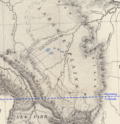
From the 1845 map by Frémont and Preuss. Stars mark points where longitude and latitude were determined. At triangles, they measured the sun's height at noon to estimate latitude.

However, if we continue our examination, we're soon confused. Is that low mountain range paralleling the Medicine Bows Jelm and Sheep Mountains? Doesn't look right. Nor does the ridge east of the Main Fork. Most puzzling is the “Right Hand Fork” which (supposedly) joins the Main Fork of the Laramie River before it enters the canyon. Our history buffs still haven't solved this mystery.

Errors at this scale aren't surprising. With the great expanse of unknown territory ahead, there was little time for finer details, and though Preuss' map was highly accurate in its time, it's a far cry from the "very interesting map” showing every hill and canyon, which would so excite a Boomerang reporter 50 years later ...

[More to come in Part II.]

This post is based on the first of two articles about mapping the Laramie Plains, my most recent contribution to the "Laramie History" column in the Laramie Boomerang.

Monday, March 25, 2013

JC Frémont was here

A Fremont cottonwood grows along the Fremont River in southeast Utah.
John Charles Frémont (USA; 1813-1890) was a mathematician, explorer, topographer, expedition leader, military commander, entrepreneur and politician.  He was considered a hero and a scoundrel, visionary and foolish, was court-martialed for mutiny, lost a presidential election, lost a fortune to poor investment in spite a powerful political position, and was one of the greatest explorers of the American West.  But was this man a botanist?
General J.C. Frémont, from the Carll H. de Silver Fund, Brooklyn Museum Online Collection.

His adventures began with a two-year stint as a math teacher aboard a naval vessel off the coast of South America.  Next he landed a job as an engineer on a railroad survey project, and then in 1838 was made assistant to the accomplished topographer Joseph Nicollet on pioneering surveys between the Mississippi and Missouri Rivers.  Bright and ambitious, Frémont quickly learned the topographer’s trade, and when Nicollet became ill, he took over as leader.  By this time, his application for a commission had been approved, making him a Second Lieutenant in the US Topographical Corps.
The travels of John Charles Frémont.  Sierra Nevada in red, Great Basin in blue.
Frémont went on to lead five exploratory expeditions across the American West for the Army Corps of Topographical Engineers (above), producing much-needed maps and dispelling geographical myths.  His second and third expeditions circumnavigated the Sierra Nevada of California, crossing the range in mid-winter twice (bold? or foolhardy?) and quashing all hopes of finding the Río Buenaventura, said to flow from the interior to the sea.  Instead they discovered an immense area of interior drainage east of the Sierra Nevada where no river ever reaches the sea.  Frémont named it the Great Basin.
Sign courtesy Inyo-White National Forest; click photo to read.
The 19th century was a grand time for plant collectors as well as topographers.  The flora of western North America was very poorly known, and there were tremendous opportunities for finding "novelties" -- plants new to science.  The collectors themselves were a disparate group.  Some were educated botanists but many were self-taught, perhaps with a bit of training in proper preparation of specimens in the field.  They included pioneer settlers, farmers, gardeners, doctors, army officers and miscellaneous free spirits -- all captivated by the promise of botanical discovery.

Frémont recognized the need for botanical material and insisted that specimens be collected on his expeditions.  He himself was the “botanist” on all but one.  He probably was first exposed to plant collecting on the Nicollet expeditions, observing the work of botanist Karl Geyer.  Later, he received advice and direction from the academic botanists to whom he sent his collections.  “Lieut. F. must be indoctrinated, & taught to collect both dried spec. & seeds” wrote botanist Asa Gray of Harvard.
Asa Gray in 1864; photo by John Whipple.
Plant collecting in Frémont's time was not all that different from now.  Specimens were preserved in the field by pressing and drying, and had to be dried fairly quickly to prevent decay and minimize discoloration.  This is easy to do today, at least in the semi-arid country where I work.  Plants are placed in folded sheets of newspaper between pieces of corrugated cardboard making up a plant press.  One can simply strap the loaded press on top of the truck and let warm dry air stream through corrugations in the cardboard.  An alternative, if one is close to civilization, is to set the press on a “plant drier” where heat from lightbulbs dries the contents (too much heat will ruin specimens).
Tools of the trade.
For 19th-century field botanists, drying pressed plants was much more difficult.  Specimens were placed between sheets of paper to absorb moisture.  These had to be changed and dried regularly -- daily if possible.
“We sit for hours before a hot camp fire, with the sweat pouring down our face, to completely dry our papers and plants.  How I wish the plants dried at once, but often it takes several days and sometimes a week ... Each day we must press them between dry paper.  And what a misery when it rains; then nothing or no one is dry!  When it is windy our scarce paper blows out into the meadows.” -- anonymous plant collector (Nilsson 1994).
Once dried, plant specimens had to be kept dry ... and safe.  Many of the collections made on Frémont’s second expedition were lost in a series of accidents, much to his dismay:
“In the gorges and ridges of the Sierra Nevada, of the Alta California,we lost fourteen horses and mules, falling from rocks or precipices into chasms or rivers, bottomless to us and to them, and one of them loaded with bales of plants collected on a line of two thousand miles of travel”
 “when almost home, our camp on the banks of the Kansas was deluged by the great flood, which, lower down, spread terror and desolation on the borders of the Missouri and Mississippi, and by which great damage was done to our remaining perishable specimens, all wet and saturated with water, and which we had no time to dry.”
On the third expedition, Frémont went to great pains to minimize losses.  When they reached the California coast, plant specimens were packed in tin boxes, the ends soldered shut.  These were placed in wooden boxes wrapped in green cowhides, shipped to Panama, transported across the isthmus, and then put on a ship bound for New York, finally reaching the closet botanists eagerly awaiting plant material from the West.
Botanist John Torrey was Frémont's main academic contact; portrait from Harvard University Library.
Most of the plant collectors exploring the western US in the 19th century had little or no training in plant classification.  Specimens were sent east to academic botanists working in herbaria -- called “closet botanists” in the day.  Frémont sent his first batch to John Torrey of Princeton and Columbia Universities.  He did so “somewhat presumptuously” (Welsh 1998), i.e. without prior arrangement, but the package was eagerly accepted by Torrey even so.  He knew the value of the material and the potential for novelties.  Torrey forwarded part of the collection to his colleague at Harvard, Asa Gray.
The California fremontia or flannelbush (Fremontodendron californicum) was named in honor of JC Frémont by John Torrey.  Source.

At least 2100 plant collections from Frémont’s five expeditions went to Torrey, Gray and other closet botanists.  These were to yield 163 new types of plants, including 19 new genera.  This was especially impressive given the great difficulty of collecting specimens:
“... explorations were made on horseback, and by such rapid movements, (which were necessary, in order to accomplish the objects of the expedition,) that but little opportunity was afforded for collecting and drying botanical specimens. Besides, the party was in a savage and inhospitable country, sometimes annoyed by Indians, and frequently in great distress from want of provisions; from which circumstances, and the many pressing duties that constantly engaged the attention of the commander, he was notable to make so large a collection as he desired.” -- John Torrey (in Frémont 1845).
In his report for the second expedition, Frémont told of finding a new kind of cottonwood in the valley of the Santa Clara River in today’s southern Utah.  If he collected any material, it did not survive.  He encountered it again in California on the third expedition, and collected a specimen along the Sacramento River.  It was in the shipment sent to New York by way of the Isthmus of Panama, and finally ended up in the hands of botanist Sereno Watson at Harvard, who in 1875 named it Populus fremontii, the Fremont cottonwood -- one of 40 plant species that now bear Frémont’s name.
“The stream is prettily wooded with sweet cottonwood trees -- some of them of large size ... This cottonwood is of a different species than any in Michaux’s Sylva” (Frémont 1845). Above, a Fremont cottonwood stands before the capitols of Capitol Reef National Park, Utah; below, with cross-bedded sandstone in Harris Wash, Grand Staircase Escalante National Monument, also in Utah.
There are more of Frémont's plants nearby.  Fremont mahonia (Mahonia fremontii) grows on the slopes just above Harris Wash.  Below, a single (compound) leaf with thick sharply-toothed leaflets, followed by the shrub.
Most of Frémont’s discoveries were described and published by others, but not all.  After the first expedition, he asked John Torrey if he might join him as a coauthor.  Torrey agreed, and some 18 species would be published with “Torr. and Frém.” as authorities (cited authors).
Pinus monophylla Torr. and Frém., the single-leaf pinyon (from Frémont 1845).
But was John Charles Frémont a botanist?  In discussing Frémont’s botanical legacy, Welsh (1998) calls him a botanical explorer but not a professional botanist.  The man certainly was dedicated to the profession, dutifully collecting and drying plants in spite of all the hardships and difficulties of traveling through unknown country by horseback for many months at a time.  To his credit, he generally kept detailed records of specimens and collection locations.  He must have known the flora well enough to recognize plants of interest.  Finally, there's no doubt that his botanical discoveries -- including 163 novelties -- were a major contribution to our knowledge of the flora of the American West.  Sounds like a botanist to me.
The USA 5c stamp of the 1898 Trans-Mississippi issue featured botanist John Charles Frémont. 

Sources (in addition to links in post)

Frémont, J.C.  1845.  Report of the exploring expedition to the Rocky Mountains in the year 1843, and to Oregon and North California in the years 1843-1844.  Washington, DC  Senate Doc. 461, 28th Congress.

Nilsson, K.B.  1994.  A wild flower by any other name; sketches of pioneer naturalists who named our western plants.  Yosemite National Park:  Yosemite Association.

Welsh, S.L.  1998.  John Charles Frémont, botanical explorer.  Saint Louis:  Missouri Botanical Garden Press.