|
| "[The Coteau des Prairies] is a most beautiful tract of land, diversified by hills, dales, woodland, and lakes; the latter abounding in fish" (Joseph Nicollet, 1843). |
In the late 1830s cartographer Joseph Nicolas Nicolett, recently arrived from France, surveyed the great triangle between the Missouri and upper Mississippi Rivers. He found the landscapes novel, as did French explorers before him. They "were so forcibly impressed with this novelty in the appearance of the topography, that they employed new names to designate it ... Coteau des Prairies, Coteau des Bois, Hauteurs des Terres, and rolling, flat, or marshy prairies" (all Nicollet quotes are from his 1843 Report).
During his surveys Nicollet studied and described the local geology as best he could. Unfortunately he was hampered not just by his own limited knowledge but by that of geology itself, still very much a young science. A case in point was the "erratic deposite" (obs. sp. of deposit) he inevitably found immediately beneath the soil—jumbled accumulations of sand, gravel, pebbles, clay, and most curious, rounded boulders from afar.
 |
| Nicollet's survey area; annotated excerpt from 1969 USGS topographic map. |
When we left Nicollet last month, he was preparing a report to accompany his map. He devoted an entire section to Erratic deposites—"species of deposite of the kind for a long time known by the name of diluvium; but as this word implies a theoretic idea as regards the accumulation of such deposites, the cause of which is still open to controversy ... I have, therefore, used the latter expression [erratic deposites]". Thus Nicollet managed to avoid a raging debate then underway. But not for long.
These deposits had long puzzled geologists. Why were they a jumbled mix of type and size, unlike the nicely stratified alluvium of streams and lakes? How did immense rocks travel so far? The widely-accepted explanation was the Diluvial Theory, which invoked a global flood—the Hand of God—to answer such difficult questions.
But revolution was in the air. Geologist Louis Agassiz was pushing the Glacial Theory, arguing that during glacial epochs ice from the north advanced far south and mountain glaciers flowed to lower elevations. This is why we now find glacial features—striations, polish, jumbled deposits, and such—far from any ice.
 |
| "How vast must have been the impulsive force which could carry such enormous masses ... deposited for the surprise of the geologist or the contemplation of the thoughtful!" (Figiuer 1863) (1) |
In the spring of 1843, the Association of American Geologists and Naturalists held its fourth annual meeting. Among subjects discussed was the highly controversial drift (American term for erratic deposits). A committee of experts had been assembled the year before, Nicollet among them. Now each would share his findings and conclusions.
In the Abstract of the Proceedings (AAGN 1843), we see that even expert geologists were unable to escape the thinking of the times. Glacial epochs and ice sheets reaching far south were impossible (!) and therefore useless in explaining the drift. A Dr. C. T. Jackson set the tone: "Many eminent men incautiously embraced the new theory, which within two or three years from its promulgation, has been found utterly inadequate, and is now abandoned by many of its former supporters. This was the glacial theory of the celebrated Agassiz of Switzerland." [emphasis mine]
Nicollet spoke next, unscripted. The Abstract shows the strength of his opinion: "Mr. Nicollet then rose and addressed the meeting at considerable length and with great animation on Jackson's paper just read, and in opposition to the glacial theory of M. Agassiz. He expressed his astonishment that M. Agassiz should have entirely overlooked the labors of his predecessors in the same field, and particularly of M. De Saussure, who spent forty years in investigating all their phenomena, and had nearly exhausted the subject."
Oddly, Nicollet also stated that a glacier couldn't possibly "score and furrow the rocks in its path" due to the grotto-like passageways beneath it (2). Surely he knew better, having grown up in the Alps. But we must keep in mind that Nicollet was a very sick man. Several days later he was unable to present a paper he had prepared; a colleague read it for him. He died that September. In his small library, his friends found Agassiz's Etudes sur les glaciers (1840). Was Nicollet in his right mind when he opposed the Glacial Theory? Was he too weary to resist the anti-Agassiz fervor?
 |
| Nicollet probably had been ill for several years when he died in 1843, at age 57. |
Diluvialism would hold its supporters captive far longer than now seems reasonable. In fact decades would pass before ice ages were fully accepted (Hanson 1970). But finally, glacial evidence became too abundant to ignore. Consider South Dakota, for example.
Of the many people who speed across South Dakota every day, I bet few if any think of glaciers. Yet half the state was covered in ice multiple times, and not all that long ago. The great Ice Age, the Pleistocene, lasted from c. 2.5 million to just 11,700 years ago (source). It was not a single event but a series of glacial and interglacial episodes.
 |
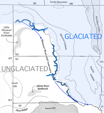
| Glaciation in North and South Dakota; modified from Johnson & Knight 2022. |
In a sense that ice is still with us, for it profoundly shaped the land, creating undulating terrain, fertile soils with foreign boulders, high coteaus covered in ponds and lakes, and a dramatic change in landscape east and west of the Missouri River, itself a product of ice. These were the things I had come to see.
Like Nicollet, I started my tour of eastern South Dakota near Fort Pierre on the Missouri River. Much had changed of course. Fort Pierre is gone (not to be confused with nearby Pierre, the state capital). Some would claim the Missouri is gone as well, flooded by Lake Oahe. "The astonishingly richer vegetation" described by Nicollet east of the river is almost entirely gone, replaced with fields of corn, wheat, soybeans, and sunflowers. Yet glacial features are still apparent and in some cases more so, thanks to satellite imagery, high tech mapping, and rock pickers.
On a good relief map, South Dakota's distinctive drainage patterns are obvious. In the unglaciated west, tributaries flow east into the Missouri River. But east of the river there are no tributaries to speak of, only a few southerly-flowing streams. This is a recent development. Just 150,000 years ago or so, streams west of the river continued east in valleys now buried in glacial drift. And there was no Missouri River except for a stretch in the southeast corner of the state (Gries 1996).
 |
| From Shaded Relief Maps of South Dakota, SDGS; labels added. |
The Missouri likely was born mid-Pleistocene, during the Illinoian Stage when all of eastern South Dakota was glaciated. Advancing ice blocked east-flowing streams, diverting them south and east along the ice sheet margin. This new stream apparently was quite powerful, for it cut a channel 300–700 ft deep—enough that the river stayed put when the ice melted away (Gries 1996).
From the Missouri, I drove east across a seemingly endless patchwork of cultivated fields. These too are glacial products—the fertile soils of eastern South Dakota started with ice.
 |
| Somewhere in eastern South Dakota; courtesy Google Earth. |
A massive sheet of flowing ice easily fractures the surface below, mainly via freeze/thaw cycles. The resulting debris is "plucked" by the glacier and frozen into its base, enhancing the giant rasp and grinder. When the ice sheet melts, it drops its baggage—the diluvium, erratic deposites, and drift of geologists past. Today's geological term is glacial till, or more specifically, ground moraine. Farmers call it "boulder clay".
The till in eastern South Dakota is thick—c. 40 ft on average, and in some places exceeding 500 ft. It's composed mainly of fragments of local bedrock, mostly shale. This explains the clay in " boulder clay". But what about the boulders?
The abundant boulders of eastern South Dakota are composed of granitic, metamorphic, and occasionally very hard carbonate rocks—very different from local bedrock. These are travelers from the North Country, "glacial erratics" transported by ice from somewhere in Canada (Bluemle 2016).
 |
| Glacial erratics as riprap, Lake Oahe. |
As Nicollet noted, "this deposite always occurs between the vegetable soil and the rocky strata [bedrock] ...", i.e., mostly buried and out of sight. But as I drove past ag fields there was no need to seek out cut banks, gravel pits, construction sites, and such to see glacial erratics. Rock-picking farmers have made them easy to spot. "Nearly every farm north of the Missouri River in eastern South Dakota can point to its very own small mountain of rocks left scattered across the area by glaciers" (from Man Turns Rock Piles Into Big Business).
"Folks who first wanted to farm these prairies had to remove the rocks before they could plow, and still have to do that regularly. Winter cold and spring thaws heave buried boulders to the surface every year, and 'picking rocks' is an ongoing pastime for Dakota and Montana farmers. Mechanized pickers with inspired names like Rock-o-matic, hauled behind tractors, replacing the horses, wagons, and manual labor of the pioneer era, make this task easier nowadays." (from Dave Rintoul's Letter to America)
 |
| Rock pile with Brewer’s blackbird, north of Stanley, North Dakota. Photo by Dave Rintoul. |
 |
| Excerpt from map of Lewis & Clark expedition. Coteau des Prairies upper right, labeled "High Land covered with Wood called Mountain of the Prairie" (source). |
The Coteau extends south to north roughly 200 mi through eastern South Dakota and into North Dakota. It reaches a width of c. 70 mi and rises 600+ ft above the lowlands of the James and Minnesota Rivers. The crest is a mix of grassland, woodland, and lots of water—wetlands, ponds, and lakes—which surprised travelers new to the country. Why are lakes abundant high on the Coteau when the valleys below have so few?
 |
| Re-I-Paha, head of the Coteau des Prairies; Nicollet often used local names. Note the many lakes. Source. |
 |
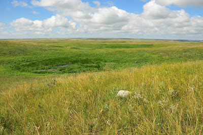
| View from crest of Coteau des Prairies, Minnesota River lowlands in distance. |
 |
| Hiking in hardwood forest on the Coteau; glacial erratics in foreground. |
Some geologists think the Coteau was sculpted millions of years before the Ice Age, during major episodes of erosion, especially during mid Miocene time (17 to 15 million years ago). Much of the prominent erosional topography of western South Dakota was created then—buttes, escarpments, and badlands (Gries 1996). Surely such features also were present in the east (same bedrock) ... until they were ground down by glaciers and buried under thick layers of till.
Perhaps the Coteau des Prairies was a preexisting topographic feature too substantial for ice sheets to remove or bury entirely in till. "Before glaciation, the Prairie Coteau was probably an outlier of Cretaceous sandstone standing above a surrounding shale surface" (Bluemle 2016). Flint (1955) considered it "a bedrock feature and the main form has not been obscured by the irregular blanket of drift that mantles it."
 |
| Slim Buttes in northwest South Dakota. Did the Coteau des Prairies look like this before the ice arrived? |
And what about all those lakes and ponds ... ?
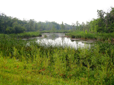
Apparently ice sheets sometimes flowed up onto the Coteau des Prairies, where they were "stranded and abandoned", forming massive dead-ice moraines (Bluemle 2016). When the ice melted, thick layers of till were left behind (3). Buried in the till were huge blocks of ice. When these finally melted, perhaps several thousand years later, water-filled depressions were left behind—today's abundant wetlands, ponds and lakes. They remain as beautiful today as they were in Nicollet's time.
 | |
| Lakes on Coteau des Prairies (dark greenish); lowlands upper left and right (Google Earth). |
 |
| Evening on Pickerel Lake, where Nicollet camped three nights in 1839. |
Notes
(1) Look closely. This image of the Deluge shows massive rocks being carried by icebergs—a modified diluvial theory promoted by geologist Charles Lyell (Hanson 1970).
(2) Passages with flowing streams do form beneath glaciers, but the ice can still "score and furrow the rocks". Also, some sources incorrectly state that Nicollet described glaciers as "hollow" at the base; the AAGN Abstract shows otherwise.
(3) Bluemle (2016) hypothesized that when glaciers advanced up the steeper escarpments of the Coteau, internal stress caused shearing in the ice, loading it with large amounts of rock and sediment from below. This would explain the thick till atop the Coteau.
Sources
AAGN (Assoc. Amer. Geologists & Naturalists) 1843. Abstract of the Proceedings of the Fourth Session. Am. J. of Science & Arts 45:310–352 (Nicollet's remarks p. 323). BHL
Agassiz, L. 1840. Etudes sur les glaciers. Smithsonian Libraries.
Bluemle, JP. 2016. North Dakota's Geological Legacy. North Dakota State University Press.
Bray, E., & Bray, MC. 1976. Joseph N. Nicollet on the plains and prairies: the expeditions of 1838–39, with journals, letters, and notes on the Dakota Indians. Minnesota Hist. Soc.
Figuier, L. 1863. (Bristow, LH, ed. 1872). The World Before the Deluge. See p. 425 for proof of a deluge in northern Europe. Project Gutenberg
Flint, RF. 1955. Pleistocene geology of eastern South Dakota. Geol. Surv. Prof. Paper 262.
Gries, JP. 1996. Roadside Geology of South Dakota. Mountain Press Publ. Co.
Hansen, B. 1970. The early history of glacial theory in British geology. J. Glaciology Published online by Cambridge University Press.
Johnson, WC, and Knight, DH. 2022. Ecology of Dakota Landscapes; past, present, and future. Yale University Press (reviewed here).
Nelson, Mike. 2014 (Jan 29). Geology: eastern South Dakota. CSMS Geology Post.
Nicolett, JN. 1843. Report intended to illustrate a map of the hydrographical basin of the upper Mississippi river. US Senate, 28th Congress, 2nd session, no. 237. BHL