Showing posts with label Lewis & Clark. Show all posts

Sunday, December 8, 2024

Osage Orange—God's Gift to the Prairie Farmer

"this curious fruit, which, when first discovered lying neglected beneath the tree, led the voyagers to fear and report it as a poison" wrote Thomas Nuttall (1842). Pete unseth photo.
In March of 1804, Meriwether Lewis, co-captain with William Clark of the Corps of Discovery, stopped at the home of trader Pierre Chouteau in St. Louis (Missouri Territory). The Chouteau brothers were supplying their expedition, which would depart in May, but this visit was for another matter. Lewis wanted to see Chouteau's garden.

President Thomas Jefferson had appointed Lewis expedition botanist. He was to study and record "the soil & face of the country, it's growth & vegetable productions, especially those not of the U.S. and the dates at which particular plants put forth or lose their flower, or leaf" (source). Given this assignment, there was good reason to visit Chouteau. The trader had lived in Louisiana Territory since birth, knew the Osage Indians well, and was familiar with their use of native plants, some of which he had planted in his garden.

Pierre Chouteau; Missouri Historical Society.
Lewis took cuttings from Chouteau's trees, and sent them to Jefferson, with a letter of explanation:

"I send you herewith inclosed, some slips of the Osages Plums, and Apples. I fear the season is too far advanced for their success. Had I earlyer learnt that these fruits were in the neighbourhood, they would have been forwarded at a more proper time ... I obtained the cuttings, now sent you, from the garden of Mr. Peter Choteau (1), who resided the greater portion of his time for many years with the Osage nation ..."

In his letter Lewis also explained the value of the Osage Apple (today's Osage Orange), presumably learned from Chouteau. "So much do the savages esteem the wood of this tree for the purpose of making their bows, that they travel many hundred miles in quest of it." Decades later, the tree would be highly esteemed by farmers as well—on the great sea of grass to the west.

In 1810 or thereabouts, another botanist visited Pierre Chouteau's garden. Thomas Nuttall, recently arrived from England, took a particular interest in the Osage Apple, which had not yet been introduced to science. He published the new species in 1818, naming it Maclura aurantiaca to honor his friend, geologist William Maclure; aurantiaca means orange, referring to the color of the wood. In 1906, this was replaced with the currently accepted name, Maclura pomifera (2).
"The wood is very heavy and of a Saffron yellow ..." wrote Nuttall (1818). Fernando Lopez Anido photo.
Nuttall's description was incomplete. For one thing, he hadn't seen any male flowers (Maclura flowers are unisexual; trees have either male or female flowers). This did not keep him from publishing, for the female flowers, and especially the fruit, are what make the species so distinctive.

Nuttall noted that Maclura's female flowers are arranged in dense globose clusters. Though tiny, each one has a style nearly an inch long. At maturity the 1-seeded fruits of the many flowers in a cluster coalesce into a "compound berry" (now known as a multiple fruit) containing "pulp nearly as succulent as that of an orange, sweetish and perhaps agreeable when fully ripe" (Nuttall also lacked information concerning edibility).

Maclura's female inflorescence of numerous tiny flowers, each with a long narrow style. H. Zell photo.
The Osage Orange is a multiple fruit (Nuttall's compound berry). H. Zell photo.
Multiple seedlings from a multiple fruit. Cbarlow photo.
Thirty years later, Nuttall, by then an acknowledged expert on the North American flora, was engaged in a monumental project—three supplemental volumes to François-André Michaux's North American Sylva (forest trees). Among the added species was Osage Orange. It appeared in the first volume, with a lengthy description and two beautiful plates.
Osage Orange, also called Bois d'Arc meaning Bow Wood (3): branch of a male plant on right, note the stout thorns; female flowers with long styles lower left; source.
Osage Orange; cross-section showing flowers united to form a multiple fruit; source.
Nuttall now had better information about edibility: "The fruit, when ripe, is succulent, has a sweetish but insipid taste, and is somewhat acrid. As far as we know, it is not eaten by any animal" (4). Also of interest (and timely) was an item in his description of the wood: "Another important use of the Maclura ... is that of forming live fences or hedges, for which purpose it is well adapted, as it bears cutting, grows close, and is very thorny."

OSAGE ORANGE—Can any one tell us more of this tree? We are desirous of having our columns made the vehicle for communicating information of any material that may be made valuable for hedging. This tree ... seems well adapted for that purpose; and if any has been used in Missouri or elsewhere, it would be a great favor to have an account of it furnished us. The Prairie Farmer, Vol. 1 No. 1, January 1, 1841.
While Nuttall was finishing his first volume, John A. Wright, a real estate speculator in the muddy young town of Chicago, was pursuing his dream. He wanted to help farmers who were struggling on the great sea of grass stretching a thousand miles to the west—"an open plain, so barren of timber, so huge of expanse as to bewilder, often frighten, them." The accumulated wisdom of settlers in wooded country to the east was of little use. Instead of clearing trees, prairie farmers toiled to break thick tough sod. And in the absence of trees, wood had to be imported at great expense (Lewis 1941).
No trees? Use sod! Soddy (sod house) in 1901; photographer unknown.
The need for helpful information was dire. Toward this end, Wright drummed up financial support for a non-partisan apolitical newspaper specifically for farmers. Though he had never farmed himself, he agreed to be the editor. On January 1, 1841, the first issue of The Union Agriculturalist and Western Prairie Farmer (soon shortened to The Prairie Farmer) was published (5).

On the front page, Wright appealed to readers for help:
TO THE PRACTICAL FARMER—Upon you we must rely for the matter that is to make this paper interesting and valuable. ... What we wish is this—as soon as any one obtains any valuable agricultural information, a recipe, a plan, or any other matter that would be adapted to our paper, that he would sit down immediately and communicate it. In this manner communications will be more to the point than if writers delay till they can collect several facts. ... if as soon as a farmer obtains one fact, he sends it, it will be what we want—"short and sweet."
Wright was well aware that some, perhaps many, would hesitate to contribute:
Many farmers may perhaps decline communicating their knowledge, because they may feel themselves incompetent to write for publication. To such we would say, that we most earnestly request you to send us articles, and should there be a word mis-spelt, or a sentence that might be improved by a little alteration, we will use our endeavors to make it right. What we want are facts—and perhaps a fact a farmer might possess, and which he declines sending, because he may perhaps not have enjoyed advantages of education in early life, might be of more service to the West, than all the matter we might publish in several numbers [issues].
Among Wright's passions was fencing, understandably. One of the biggest problems farmers faced was marauding wildlife and livestock. The cost of imported wooden fence was prohibitive and wire fences of the day—horizontal unarmed strands—were ineffective. So farmers tried hedges, also called living fences. Wright had read in the Hartford Silk Culturalist that Osage Orange trees made excellent hedges, and included that article in his paper. The final sentence was especially persuasive:
On the best authority, I am assured that the trees of the Osage Orange, when set at the distance of fifteen inches asunder, make the most beautiful as well as the strongest hedge fence in the world through which, neither men nor animals can pass.

Osage Orange—gift from God? JM DiTomaso photo (CC 3.0)
Osage Orange was soon a hot topic, with readers begging for information on where to buy viable seed and young plants. Fortunately Professor JB Turner of Illinois College had taken an interest. In the 1830s he had crossed "these beautiful prairies for some thousands of miles on horseback" concluding that whoever produced cheap effective fencing would go down in western history as the "greatest moral, intellectual, social and pecuniary benefactor." Perhaps in hopes of being that benefactor, Turner began a study of Osage Orange, periodically reporting his progress in The Prairie Farmer.

By 1848, Turner was convinced that "the Osage Orange is the shrub that God designed especially for the purpose of fencing the prairies." That November he announced he had plants for sale. He didn't know the exact price, but estimated a hedge 80 rods long (c. 1300 ft) would cost less than $15. By 1853 the price had dropped to $25 per mile, while a wooden fence "would cost $300 a mile and would be gone in 12 years" [due to prairie fires].

But in spite of its many advantages and perhaps divine origin, the Osage Orange hedge fell out of favor after just thirty years, a victim of innovation. JF Glidden of DeKalb, Illinois, had come up with a clever solution for wire fencing—barbs. Business took off immediately. The year after it started as a one-man operation, 70 men were producing three tons of fencing per day! (PF May 1875).

Both cheap effective wire fences and Osage Orange seeds were available in February 1875.

Note the clever design—"two No. 12 wires on one of which are wound the barbs ... they are then twisted holding the barbs immovable in their places" (May 1875).

Many hedges were removed and replaced with barbed wire. Others were simply abandoned. But Osage Orange trees did not disappear. Some were scavenged for fenceposts ...

Maclura posts are dense, strong, and resistant to rot and insects. Original source unknown.
... and Osage Orange hedges are still planted ...
Maclura hedge in Primorsko, Bulgaria; photo by Katya.
... and the legacy of the prairie farmers' blessing is still with us.
Thanks to prairie farmers, Maclura pomifera (dark green) occurs far beyond its original range (light green); from USDA, and Nelson et al. 2014 (6).

Notes

(1) Chouteau signed his letters apropos the recipient—Pierre Chouteau, Pedro Chouteau, and Peter Chouteau for French, Spanish, and English speakers.

(2) Osage Orange has a complicated nomenclatural history. It was first published in 1817 as Ioxylon pomifera by French naturalist Constantine Samuel Rafinesque, who then made a series of name changes: Toxylon pomiferum in 1818, Joxylon pomiferum in 1819. In the meantime Thomas Nuttall named it Maclura aurantica (1818). This became the accepted name perhaps because of Nuttall's greater botanical stature. In 1906 it was renamed M. pomifera, perhaps related to Rafinesque's first-published name. See Smith 1981. Further complications can be found in Reveal & Musselman.

(3) Maclura pomifera has many common names, including Osage Orange, Hedge Apple, Yellow Wood, Monkey Brains, Bow Wood, Bois d'Arc, Bodark and more.

(4) While Osage Orange pulp isn't edible, the seeds are. From Mike on Flickr: Osage orange trees are a magnet for squirrels. They typically sit on the ground at the base of the tree, or on a wide branch up in the tree to disassemble their prize, getting at the seeds. Piles of shredded hedge apples are a sure sign of squirrels in the area. The seeds are edible by people, but one must do like the squirrels, and remove the slimy husk to pick them out of the pulpy fruit.

(5) The Prairie Farmer is still being published, including a digital edition.

(6) The native range of Maclura pomifera is debated and probably irresolvable (Smith 1981).

Sources in addition to links in post

Earle, AS, and Reveal, JL. 2003. Lewis and Clark's Green World; the expedition and its plants. Farcountry Press.

Foley, WE. 1983. The Lewis and Clark Expedition's silent partners: the Chouteau Brothers of St. Louis. Missouri Historical Review 77:131–146. SHSMO

Lewis, L. 1941. Prairie Farmer, its beginnings. Prairie Farmer 11:5–17 (centennial edition). Illinois Digital Newspaper Collections.

Michaux, F-A, Nuttall, T, Hillhouse, AL, and Redouté, PJ. 1842. The North American Sylva; or, A Description of the Forest Trees of the United States, Canada, and Nova Scotia ... Vol. 1. BHL

Nelson, G, et al. 2014. Trees of Eastern North America. Princeton University Press.

Nuttall, T. 1818. The genera of North American plants and a catalogue of the species, to the year 1817 [Maclura 2:233]. BHL

Rafinesque, CS. 1817. Description of the Ioxylon pomiferum, a new genus of North American tree. American Monthly Magazine and Critical Review 2:118–119. Google Books

Reveal, JL, and Mussulman, JA. The Osage Orange; Maclura pomifera, in Discover Lewis & Clark (Lewis & Clark Trail Alliance). Accessed December 2024.


Saturday, March 27, 2021

Mapping the Laramie Plains I: in pursuit of the 3rd dimension

"... almost every hill and cañon can be determined at a glance!" From first Laramie, Wyoming Sheet (USGS 1895; public domain).

In the spring of 1893, Albany County Surveyor W.O. Owen received a set of preliminary maps from the US Geological Survey for review. Owen had known what to expect, but the others who saw them were surprised. "The maps are of a very interesting character ...", wrote a reporter for the Laramie Boomerang, "almost every hill and cañon can be determined at a glance!"

Indeed, the new map was astonishing—mountains and depressions around Laramie had been clearly mapped using squiggly lines! But this achievement was long in coming. For millennia, mappers had struggled to show topographical relief, to capture the third dimension on a two-dimensional sheet of paper.

Line + cones = valley
From Amennakhte's map for pharaoh Ramesses IV. Public domain.
In 1160 B.C. Scribe-of-the-Tomb Amennakhte made a map for Egyptian pharaoh Ramesses IV, who was planning a trip to quarry sandstone suitable for statues. On papyrus, he drew a broad winding line with bumpy cones lying flat on either side. With a bit of imagination, we see this is a valley lined with hills.

Amennakhte's hills look terribly crude to our eyes. Yet they aren't all that different from those appearing on maps for the next two millennia. As late as the 16th century, during early exploration of North America, mountains were shown as oversized cones, though sometimes shaded to suggest depth. Often their locations were based on distant views from sea, or rumors.
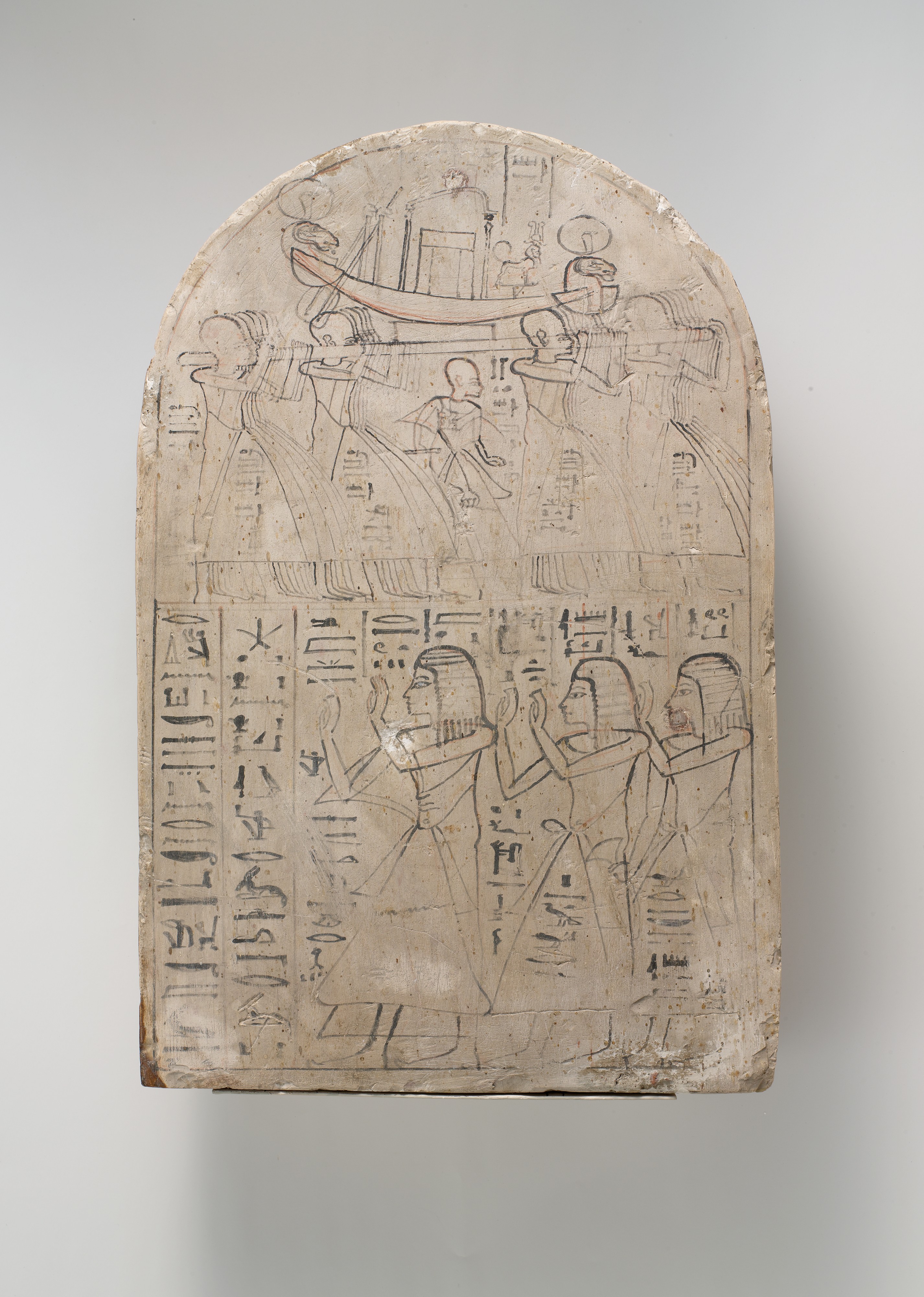
Leftmost figure is "Royal Scribe of the Place of Truth" Amennakhte. Carving on limestone, ca. 1184–1070 BC. Metropolitan Museum of Art; public domain.

Lewis & Clark map new territory

The next centuries brought significant improvements in surveying and mapping, fortunately. In the early 1800s, the young United States was in desperate need of good maps. The Louisiana Purchase had doubled the country's size. Little was known about the new territory—not even its size, nor how to traverse it.

In May 1804, the Corps of Discovery Expedition, led by Meriwether Lewis and William Clark, headed up the Missouri River in search of a route to the Pacific Ocean. In preparation for the trip, Lewis was trained in celestial navigation. President Thomas Jefferson personally provided instructions for mapping:
"... you will take observations of latitude & longitude, at all remarkable points on the river [e.g., rapids, river mouths, islands]. The interesting points of the portage between the heads of the Missouri, & of the water offering the best communication with the Pacific ocean, should also be fixed by observation ..." [Jefferson assumed they could reach a west-flowing river by carrying their boats overland.] "Your observations are to be taken with great pains & accuracy, to be entered distinctly & intelligibly for others as well as yourself, to comprehend all the elements necessary, with the aid of the usual tables, to fix the latitude and longitude of the places ..."

Lewis and Clark faithfully executed Jefferson's instructions, for three years, four months, ten days and 8000 miles.

William Clark, explorer, soldier, Indian agent, territorial governor & cartographer; portrait by Charles Peale 1810. Public domain.
Clark's map reveals a multitude of mountains

William Clark took on the job of mapmaker. In addition to the Expedition observations, he used information from explorers, trappers, natives, and earlier maps to include areas not covered by the expedition. His first map showed the Corps’ route in great detail and was necessarily huge—50+ large sheets. He then produced a single map 52 inches long and 31 inches wide, engraved and published in 1814: “A Map of Lewis and Clark's Track, Across the Western Portion of North America ...”

Among the discoveries visible on Clark's map is the structure of the Rocky Mountains. They are not a single long ridge as previously thought, but a complex system of mountain ranges and foothills. In fact, after reaching the headwaters of the Missouri, the Corps of Discovery had to travel for weeks on horseback and foot to reach west-flowing waters. A portage across the Rockies was out of the question (click on image below).
Lewis & Clark's Track. Courtesy David Rumsey Map Collection (available in high resolution).
If you click on these images, you can see that mountains were drawn with hachures—short parallel lines looking something like eyelashes. Length and curvature gave a sense of height and steepness. Hachures were denser and darker on east and south slopes of ranges, suggesting a third dimension.

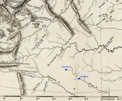
Clark's map was mostly accurate by the standards of the day. But there is a glaring error in the southern part. The Laramie Plains and surrounding mountains are missing! Little was known about the territory that would become southern Wyoming, so future Colorado and Kansas were moved north to fill the gap. This is why the Kanzas [sic] River was shown flowing where Rawlins and Laramie are today.

Today's southern Wyoming, from Lewis & Clark's Track. The Arkansas and Kansas Rivers were mapped hundreds of miles northeast of their true location, putting them in the vicinity of modern-day Rawlins and Laramie (added). Courtesy David Rumsey Map Collection.

The Pathfinder puts the Laramie Plains on the map

John C. Frémont "on the Rocky Mountains"; public domain.

In July 1843, a small contingent of the US Army Corps of Topographical Engineers climbed out of the canyon of the Cache-à-la-Poudre River, where they had hoped to find a route over the Rocky Mountains. Instead, they crossed the broad divide to the north.

In command was a young ambitious lieutenant—John Charles Frémont, the Pathfinder. This was the second of five expeditions he would lead through the American West, each time making significant contributions to geographical knowledge. He also would be court-martialed, lose a presidential election, squander large sums of money in mining schemes, and die in poverty. But all that was far in the future on that lovely summer day when the Laramie Plains came into view.

"The weather was pleasant and cool, we were disturbed by neither musquitoes [sic] nor flies; and the country was certainly extremely beautiful," Frémont would write in his report. "The slopes and broad ravines were absolutely covered with fields of flowers of the most exquisitely beautiful colors. ... As we emerged on a small tributary of the Laramie river, coming in sight of its principal stream, the flora became perfectly magnificent; and we congratulated ourselves, as we rode along our pleasant road, that we had substituted this for the uninteresting country between Laramie hills and the Sweet Water valley."

Challenges: stones, sagebrush, longitude

That evening, they camped on the Main Fork of the Laramie River, where Frémont took astronomical readings to determine latitude and longitude. While latitude seems to have been accurate, his calculation of longitude put them too far west, in the Medicine Bow Mountains near Lake Owen according to Google Earth. But that's not surprising. Estimating longitude was difficult, requiring careful tracking of stars with a precision telescope and a chronometer that kept steady time, or at least lost time at a steady rate.

For three days the party traveled northwest along the Medicine Bow mountain [sic]. The going was easy at first, but near the mountain they were slowed by large round stones in the soil. Equally difficult were ridges "made extremely rough by the stiff tough bushes of artemisia tridentata, in this country commonly called sage" [as it is today].

On August 2, they camped on the Medicine Bow River near "an isolated mountain called the Medicine Butte [Elk Mountain], which appeared to be about 1,800 feet above the plain, from which it rises abruptly, and was still white nearly to its base with a great quantity of snow". Frémont made more astronomical observations, this time including "an immersion [eclipse] of the first satellite of Jupiter." Even so, the calculated longitude again put them too far west.

After passing south of Elk Mountain, the party dropped down to the North Platte River, followed it to the Sweetwater, and continued on to California and Oregon. They would return home in August 1844, after about 15 months and 10,000 miles of travel.

A "meagre and skeleton" but valuable map (Frémont & Preuss 1845). High resolution version here, courtesy David Rumsey Map Collection. 

Dramatic report, spectacular map

Frémont wrote a colorful report about his adventures, with the help of his wife, Jesse, whose father—the powerful Senator Thomas Hart Benton—had secured funding for the expedition. Ten thousand copies were published the following year, to rave reviews. Included was the spectacular “Map Of An Exploring Expedition To The Rocky Mountains” measuring 52 x 30 inches, and stretching from the Missouri River west to the Pacific Ocean and from Los Angeles north to Mt. St. Helens.

However, much of the map was blank—to Frémont's credit. In a Notice to the Reader, he explained: "The map may have a meagre and skeleton appearance to the general eye, but is expected to be more valuable to science on that account, being wholly founded upon positive data and actual operations in the field." Indeed, the map is now considered a milestone, having set a new standard of cartographic accuracy for the American West.

The mapmaker was Charles Preuss, a trained surveyor and topographic artist from Prussia. He would accompany Frémont on three expeditions, making "continuous topographical sketches of the regions through which we passed, and which were never interrupted by any extremity of fatigue or privation" (Frémont's words). The large beautiful maps secured his reputation as a great cartographer.

Cartographer Charles Preuss, date unknown. Source (without attribution).

Laramie Plains up close

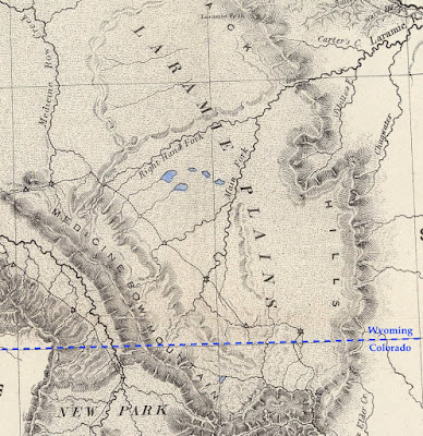
In the 30 years since publication of the Lewis and Clark map, techniques for representing relief hadn't changed all that much. Preuss also drew mountains using hachures, though in much greater detail. In the excerpt below (click to view), small narrow drainages are visible on mountains slopes, and low ridges and buttes dot the plains. Preuss varied hachures to show height and steepness. Lower ridges were drawn with shorter lines. Denser darker hachures indicated steeper slopes—for example Laramie Peak (top center of map) and, a short distance southeast, the canyon where the Laramie River crosses the Black Hills (now the Laramie Mountains).

From the 1845 map by Frémont and Preuss. Stars mark points where longitude and latitude were determined. At triangles, they measured the sun's height at noon to estimate latitude.

However, if we continue our examination, we're soon confused. Is that low mountain range paralleling the Medicine Bows Jelm and Sheep Mountains? Doesn't look right. Nor does the ridge east of the Main Fork. Most puzzling is the “Right Hand Fork” which (supposedly) joins the Main Fork of the Laramie River before it enters the canyon. Our history buffs still haven't solved this mystery.

Errors at this scale aren't surprising. With the great expanse of unknown territory ahead, there was little time for finer details, and though Preuss' map was highly accurate in its time, it's a far cry from the "very interesting map” showing every hill and canyon, which would so excite a Boomerang reporter 50 years later ...

[More to come in Part II.]

This post is based on the first of two articles about mapping the Laramie Plains, my most recent contribution to the "Laramie History" column in the Laramie Boomerang.