 |
|
Curiously-arranged stones say it used to be much colder, and not that long ago.
|
Laramie winters are cold, with daily highs generally below freezing. Winds blow hard, often 30 to 40 mph, gusting to 50, 60, even 70. When arctic air masses visit, temps drop well below zero (F) and we post numbers and pictures on Facebook to show what we have to endure. But we shouldn't brag. Our local rocks and dirt tell us that Laramie weather could be much worse.
Twelve thousand years ago—a mere blink of a geologic eye—an ice sheet covered North America as far south as today’s central Montana, North Dakota, and eastern South Dakota. It never reached Wyoming, but we weren’t exempt from the bitter cold. Most of our basins contained permafrost, with only the uppermost soil melting in summer. When it refroze, expansion cracked the surface, year after year, creating networks of polygons. Now they’re buried under soil, except where fortuitously revealed by disturbance.
 |
|
Relic frost polygons exposed during road construction at Crescent Junction, Wyoming (Mears 1987).
|
 |
|
Frost wedges (polygons in cross-section) at the Rawlins city dump (Mears 1987; arrows added).
|
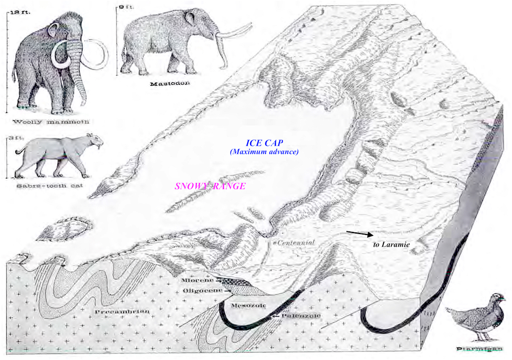
In the mountains, it was cold enough that snow survived summer melting. It accumulated, turned to ice, and began to flow, as glaciers. In the Medicine Bow Mountains west of Laramie, alpine glaciers merged into an ice cap across most of the crest, except for the highest part—the Snowy Range, a long steep-sided ridge of hard quartzite. Glaciers scratched and polished the rock only at the base; snow and ice didn’t accumulate above, at least not enough to form glaciers.
 |
|
The Snowy Range stood above the alpine ice cap (SH Knight 1990).
|
 |
|
Field assistant cavorts on the gently-rolling crest of the Medicine Bows; Snowy Range behind.
|
Though unglaciated, the Snowy Range was not immune to cold. Frigid conditions left their mark in other ways, most obviously the abundant felsenmeer (rock seas)—massive accumulations of boulders created by water! Bit by bit, expansion with freezing shattered solid quartzite into huge jumbled piles of angular blocks.
The trail to the summit of Medicine Bow Peak repeatedly crosses felsenmeer, fortunately via paths built by trail crews. The summit itself is a giant rockpile.
 |
|
My old pal Sparky takes a break en route to Medicine Bow Peak.
|
 |
|
Final section of trail to the summit. See any patterns in the plants and rocks in the foreground?
|
 |
|
Emmie summits Medicine Bow Peak, her first ascent.
|
 |
|
View of meadow from summit trail, in late August.
|
 |
|
Meadow on basalt dike; older sources call it diorite.
|
 |
|
Dike from below, near Sugarloaf trailhead.
|
From the right perspective, one sees that rocks in the little meadow are not randomly scattered. They outline polygonal patches of vegetation. Sound familiar? Yes, these are permafrost features—stone nets. Rocks and dirt were sorted, by annual freeze-thaw. Currently, active stone nets are common in Alaska, northern Canada, and other places with permafrost.

Above, stone nets seen from the trail to Medicine Bow Peak, looking south (Mears 1962). Below, roughly the same view in 2016; the nets are much harder to see. The illustrator emphasized rocks over plants, for clarity.

In the early 1960s, researchers dug a trench to study structural details. Larger rocks had accumulated along the sides of the polygons, with slabby ones often oriented on-edge. A dark (organic) layer of soil supported vegetation; plant roots extended as deep as three feet. When the study was over, they refilled the trench.

These stone nets are easiest to see from the ground, looking west slightly downhill (e.g. photos below). On gentle slopes, rocks have been sorted into lines that anastomosed into polygons. On steeper areas they form stripes.
As far as I could tell, common plants included alpine avens, moss campion, short sedges and a nearly-prostrate alpine willow. I need to return when things are blooming!

At the time of Mears’s 1962 publication, no one understood the mechanism behind frost sorting. Since then, computer modeling has suggested that with severe freezing, wet rocky soil expands enough to lift larger rocks and push them aside. Finer materials remain because they flow in response to frost heaving (more details here).
 |
|
Sorted rocks are covered in lichen, suggesting they haven’t moved in awhile.
|
Developed soil, vegetation, long plant roots, and lichen-covered rocks indicate these stone nets are no longer active. But that could change. If another glacial episode were to override our global warming, stone nets and frost wedges would grow again. And here in Laramie, it may not have to be all that much colder!
 |
|
Blizzards often close I-80, filling Laramie with trucks. Would life go on if glacial times returned?
|
• • •
Thirty-three years have passed since we lined up along a ditch to admire relic frost wedges, but the memory is still vivid. It was early October and snowing Laramie snow—horizontal with the wind. Doc Mears spoke of Pleistocene times 12,000 years ago, his strong baritone easily penetrating the howling wind, while we took notes as best we could with wet cold shivering hands. “I estimate the average annual temperature need drop just 10º C for a return to full periglacial conditions,” intoned Mears. None of us doubted it!
 |
|
Dr. Brainerd “Nip” Mears, Jr. at Hanna Junction, 1970. Mears’s discovery of relic ice wedges was a major contribution to our understanding of Wyoming paleoenvironments. Photo by Wayne Sutherland.
|
Sources (in addition to links in post)
Knight, SH. 1990. Illustrated geologic history of the Medicine Bow Mountains and adjacent areas, Wyoming. Geological Survey of Wyoming Memoir 4. PDF
Mears, B, Jr. 1962. Stone nets on Medicine Bow Peak, Wyoming. Short note, University of Wyoming Contributions to Geology (p. 48).
Mears, B, Jr. 1987. Late Pleistocene periglacial wedge sites in Wyoming: an illustrated compendium. Geological Survey of Wyoming Memoir No. 3. PDF
Mears, B, Jr. 2001. Glacial records in the Medicine Bow Mountains and Sierra Madre of southern Wyoming and adjacent Colorado, with a traveler's guide to their sites. Geological Survey of Wyoming Publ. Info. Circ. No. 41. PDF
Nnooo... It sounds plenty cold as it is! ;-) But a wonderful glimpse into the cycles that shape even rock and soil. In the Midwest it was easy to lose sight of that in the overpowering abundance of plant life. Here in the west I can't help but be aware of the nature of the soil itself...
ReplyDeleteAmy, I chuckled at "overpowering abundance of plant life" The professor in the post, Doc Mears, used to tease me (knowing I was a botanist) with "Plants obscure the landscape!"
DeleteBrrrrr...just thinking about it makes me shiver! It feels cold here in S. Wisconsin through large parts of the winter, but Wyoming is even colder and feels colder with the sweeping windchills! My husband and I camped in the Medicine Bow National Forest many, many years ago (during the summer, though). It was beautiful, but very remote. I was worried about bears and mountain lions, but it turns out mice or chipmunks caused more damage. We hid our food, but not our shoes, and some critter ate the shoelaces right out of the shoes! Thanks for the info about the stone nets, the frost wedges, and other formations.
ReplyDeleteBeth, great story about the shoelaces :-) You were lucky to visit the Med Bows when you did. They are pretty popular now, at least in summer. Luckily we locals can visit before and after, when the weather allows.
Delete