 |
| Not-so-famous dike and host rock. |
... located at the turnoff to the fire lookout at Warren Peaks on the crest of the Bear Lodge Mountains in northeast Wyoming: 44.474732° -104.441848° We think it’s famous, but then Wyoming is famous for its provinciality.
I posted the photo above to see if any readers were among the many geology-types that have traveled to and pondered this roadcut in the northwestern Black Hills ... but not. However Ron Schott, of Geology Home Companion fame, figured it out in spite of not having been there!
The Black Hills are considered the easternmost surface expression of the Laramide Orogeny, the mountain-building episode that created much of the Rocky Mountains ca 75 to 35 Ma (million years ago). The Bear Lodge Mountains are a small mountain range superimposed on the northwest part of the Hills, part of a curious and puzzling period of igneous activity that took place mainly during late Paleocene and Eocene times (ca 60 to 50 Ma). There is some evidence of a later pulse ca 10 Ma.
 |
| An igneous zone with 13 major centers and numerous minor ones crosses the northern Black Hills. The Bear Lodge intrusion is labeled 2 (after Karner 1981). |
 |
| Warren Peaks trachyte porphyry can be white to pinkish but most often is iron-stained. |
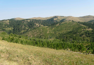
The main part of the Bear Lodge intrusion is composed of trachyte porphyry. It is crosscut by phonolite porphyry dikes, like the one exposed at the turnoff. Inclusions of basement rock -- Precambrian granite -- are common. In fact, four of the bald knobs at Warren Peaks (photo below) are underlain by a single huge granite xenolith that crops out over an area of ca 1200 by 240 m (70 acres).
 |
| Warren Peaks at crest of Bear Lodge Mountains; fire lookout on rightmost knob. |
 |
| Phonolite porphyry dike. |
 |
| Phonolite porphyry. |
The dike at the turnoff is phonolite porphyry, the same rock that makes up Devils Tower and the Little Missouri Buttes just 20 miles to the west (photo below).
 |
| Denuded igenous bodies viewed through smoke of western fires. |
At the west end of Sundance, take Highway 14 towards Devils Tower National Monument. In less than two miles, turn right on Forest Service Road 838 to Warren Peaks (signed and paved). Continue almost exactly 7 miles, past several nice exposures of Tertiary intrusive rock, to the obvious turnoff to the lookout.
 |
| Warren Peaks at the crest of the Bear Lodge Mountains northwest of Sundance, click to view. |
Literature Cited
Karner, F.R. 1981. Geologic relationships in the western centers of the northern Black Hills Cenozoic igneous province. in Rich, F.J. ed. Geology of the Black Hills, South Dakota and Wyoming. Field trip guidebooks, Geol. Soc. Amer.
No comments:
Post a Comment