 |
| "... almost every hill and cañon can be determined at a glance!" From first Laramie, Wyoming Sheet (USGS 1895; public domain). |
 |
| From Amennakhte's map for pharaoh Ramesses IV. Public domain. |
 |
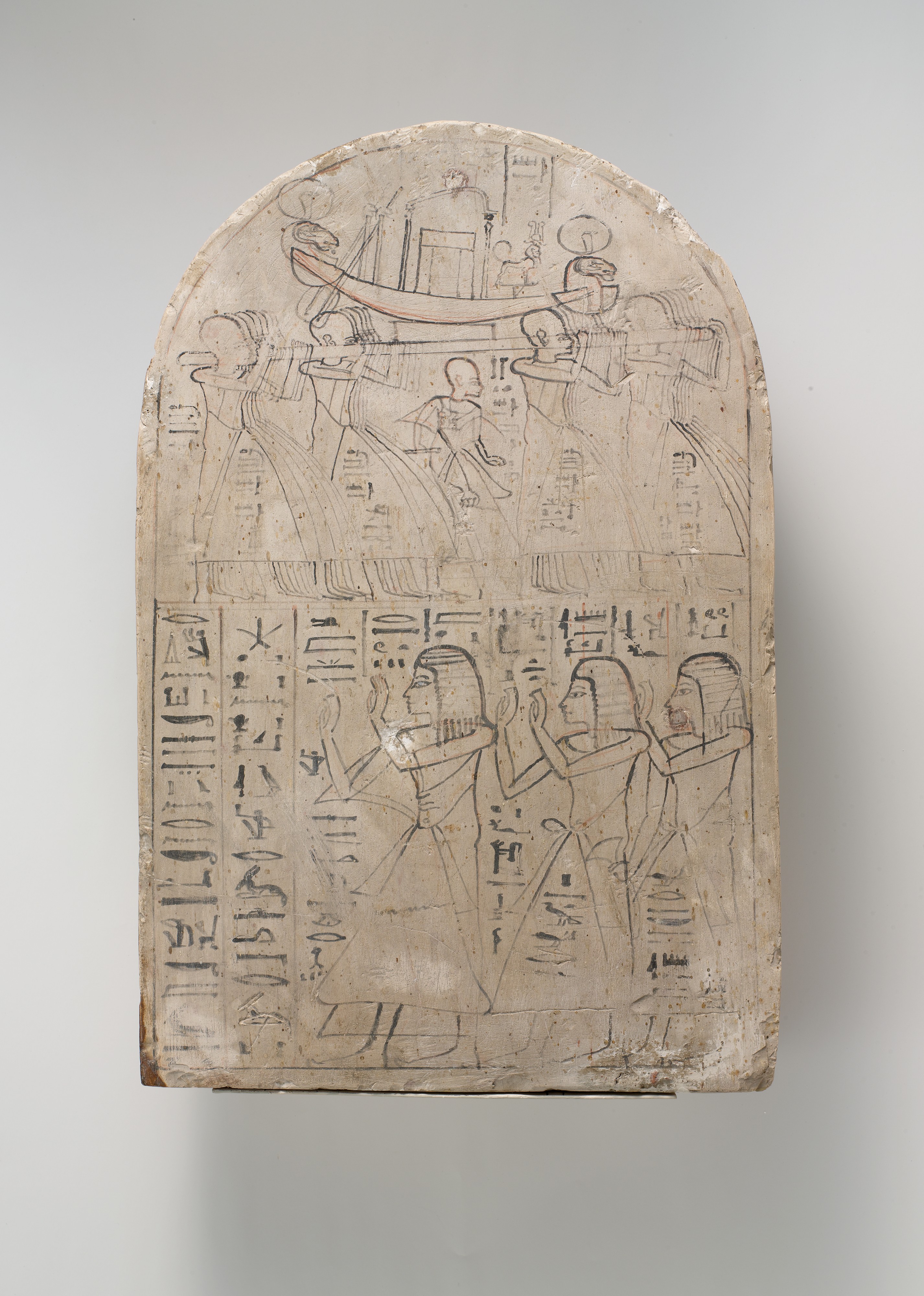
| Leftmost figure is "Royal Scribe of the Place of Truth" Amennakhte. Carving on limestone, ca. 1184–1070 BC. Metropolitan Museum of Art; public domain. |
"... you will take observations of latitude & longitude, at all remarkable points on the river [e.g., rapids, river mouths, islands]. The interesting points of the portage between the heads of the Missouri, & of the water offering the best communication with the Pacific ocean, should also be fixed by observation ..." [Jefferson assumed they could reach a west-flowing river by carrying their boats overland.] "Your observations are to be taken with great pains & accuracy, to be entered distinctly & intelligibly for others as well as yourself, to comprehend all the elements necessary, with the aid of the usual tables, to fix the latitude and longitude of the places ..."
Lewis and Clark faithfully executed Jefferson's instructions, for three years, four months, ten days and 8000 miles.
 |
| William Clark, explorer, soldier, Indian agent, territorial governor & cartographer; portrait by Charles Peale 1810. Public domain. |
 |
| Lewis & Clark's Track. Courtesy David Rumsey Map Collection (available in high resolution). |
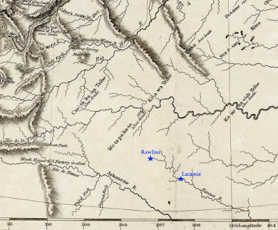 |
| Today's southern Wyoming, from Lewis & Clark's Track. The Arkansas and Kansas Rivers were mapped hundreds of miles northeast of their true location, putting them in the vicinity of modern-day Rawlins and Laramie (added). Courtesy David Rumsey Map Collection. |
The Pathfinder puts the Laramie Plains on the map
 |
| John C. Frémont "on the Rocky Mountains"; public domain. |
In July 1843, a small contingent of the US Army Corps of Topographical Engineers climbed out of the canyon of the Cache-à-la-Poudre River, where they had hoped to find a route over the Rocky Mountains. Instead, they crossed the broad divide to the north.
In command was a young ambitious lieutenant—John Charles Frémont, the Pathfinder. This was the second of five expeditions he would lead through the American West, each time making significant contributions to geographical knowledge. He also would be court-martialed, lose a presidential election, squander large sums of money in mining schemes, and die in poverty. But all that was far in the future on that lovely summer day when the Laramie Plains came into view.
"The weather was pleasant and cool, we were disturbed by neither musquitoes [sic] nor flies; and the country was certainly extremely beautiful," Frémont would write in his report. "The slopes and broad ravines were absolutely covered with fields of flowers of the most exquisitely beautiful colors. ... As we emerged on a small tributary of the Laramie river, coming in sight of its principal stream, the flora became perfectly magnificent; and we congratulated ourselves, as we rode along our pleasant road, that we had substituted this for the uninteresting country between Laramie hills and the Sweet Water valley."
Challenges: stones, sagebrush, longitude
That evening, they camped on the Main Fork of the Laramie River, where Frémont took astronomical readings to determine latitude and longitude. While latitude seems to have been accurate, his calculation of longitude put them too far west, in the Medicine Bow Mountains near Lake Owen according to Google Earth. But that's not surprising. Estimating longitude was difficult, requiring careful tracking of stars with a precision telescope and a chronometer that kept steady time, or at least lost time at a steady rate.
For three days the party traveled northwest along the Medicine Bow mountain [sic]. The going was easy at first, but near the mountain they were slowed by large round stones in the soil. Equally difficult were ridges "made extremely rough by the stiff tough bushes of artemisia tridentata, in this country commonly called sage" [as it is today].
On August 2, they camped on the Medicine Bow River near "an isolated mountain called the Medicine Butte [Elk Mountain], which appeared to be about 1,800 feet above the plain, from which it rises abruptly, and was still white nearly to its base with a great quantity of snow". Frémont made more astronomical observations, this time including "an immersion [eclipse] of the first satellite of Jupiter." Even so, the calculated longitude again put them too far west.
After passing south of Elk Mountain, the party dropped down to the North Platte River, followed it to the Sweetwater, and continued on to California and Oregon. They would return home in August 1844, after about 15 months and 10,000 miles of travel.
 |
| A "meagre and skeleton" but valuable map (Frémont & Preuss 1845). High resolution version here, courtesy David Rumsey Map Collection. |
Dramatic report, spectacular map
Frémont wrote a colorful report about his adventures, with the help of his wife, Jesse, whose father—the powerful Senator Thomas Hart Benton—had secured funding for the expedition. Ten thousand copies were published the following year, to rave reviews. Included was the spectacular “Map Of An Exploring Expedition To The Rocky Mountains” measuring 52 x 30 inches, and stretching from the Missouri River west to the Pacific Ocean and from Los Angeles north to Mt. St. Helens.
However, much of the map was blank—to Frémont's credit. In a Notice to the Reader, he explained: "The map may have a meagre and skeleton appearance to the general eye, but is expected to be more valuable to science on that account, being wholly founded upon positive data and actual operations in the field." Indeed, the map is now considered a milestone, having set a new standard of cartographic accuracy for the American West.
The mapmaker was Charles Preuss, a trained surveyor and topographic artist from Prussia. He would accompany Frémont on three expeditions, making "continuous topographical sketches of the regions through which we passed, and which were never interrupted by any extremity of fatigue or privation" (Frémont's words). The large beautiful maps secured his reputation as a great cartographer.
 |
| Cartographer Charles Preuss, date unknown. Source (without attribution). |
Laramie Plains up close
In the 30 years since publication of the Lewis and Clark map, techniques for representing relief hadn't changed all that much. Preuss also drew mountains using hachures, though in much greater detail. In the excerpt below (click to view), small narrow drainages are visible on mountains slopes, and low ridges and buttes dot the plains. Preuss varied hachures to show height and steepness. Lower ridges were drawn with shorter lines. Denser darker hachures indicated steeper slopes—for example Laramie Peak (top center of map) and, a short distance southeast, the canyon where the Laramie River crosses the Black Hills (now the Laramie Mountains).
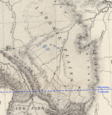 |
| From the 1845 map by Frémont and Preuss. Stars mark points where longitude and latitude were determined. At triangles, they measured the sun's height at noon to estimate latitude. |
However, if we continue our examination, we're soon confused. Is that low mountain range paralleling the Medicine Bows Jelm and Sheep Mountains? Doesn't look right. Nor does the ridge east of the Main Fork. Most puzzling is the “Right Hand Fork” which (supposedly) joins the Main Fork of the Laramie River before it enters the canyon. Our history buffs still haven't solved this mystery.
Errors at this scale aren't surprising. With the great expanse of unknown territory ahead, there was little time for finer details, and though Preuss' map was highly accurate in its time, it's a far cry from the "very interesting map” showing every hill and canyon, which would so excite a Boomerang reporter 50 years later ...
[More to come in Part II.]
This post is based on the first of two articles about mapping the Laramie Plains, my most recent contribution to the "Laramie History" column in the Laramie Boomerang.
I learn so much from your posts. I didn't know much about Fremont, and his comments about accuracy are interesting. Since about fifth grade (or maybe earlier) I've been fascinated with maps and geography. Thanks for this info about the Laramie Plains.
ReplyDeleteHi Beth, so nice to find your comment ... as always, very encouraging. I'm trying to get back to blogging, in preparation for a trip starting late april after a year of containment. I want my old life back! Best wishes.
Delete