 |
|
Twin Peaks on horizon—South Twin Peak on left, North on right.
|
 |
|
Sevier Lake/Playa (depending on rainfall) is what’s left of the Sevier Arm of Lake Bonneville.
|
For this post, we’ll call it “Twin Peaks Lake” or TPL, even though it predates both North and South Twin Peaks (more on this later). It was at its height about 2.6 million years ago—a roughly semicircular lake perhaps 90 m deep. Now all that’s left is lithified limey lake muck—freshwater limestone and other calcareous rocks. This is what I hoped to find, and during the initial drive-through, I noted areas with pale outcrops for further investigation.
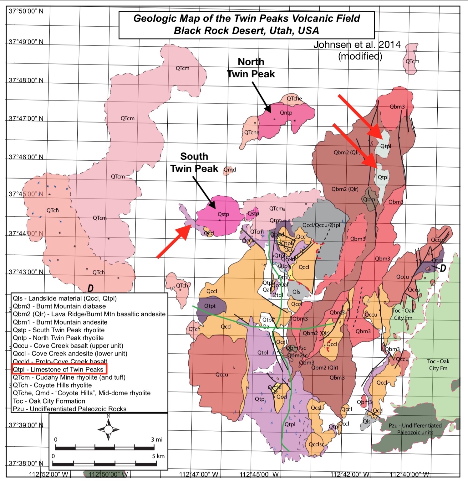
I was guided by a geological map made by Johnsen and colleagues (2014) after extensive field work and rock/element analyses. Two map units, gray and lavender, mark the limestone of Twin Peaks (Qtpl); the white unit (Qtpl/al) also includes limestone. Added red arrows mark areas searched—we found limestone at all.
 |
|
My field assistant was happy to investigate whatever wherever.
|


 |
|
“often contains small gastropod shell fragments” (Johnsen 2014)
|
The limestone of Twin Peaks consists largely of reworked volcanic tuff and other pyroclastic debris, which is held together with limy cement (calcite) and interbedded with freshwater limestone. Apparently there were active volcanoes nearby; based on the nature of the sediments, at least some of the eruptions were large and violent.
At the time of Twin Peaks Lake, the Black Rock Desert (BRD) volcanic field had been active for about four million years. Also at that time, activity was increasing significantly; most BRD volcanoes erupted during the last 2.5 million years, the youngest just 700 years ago. Activity was bimodal, with both “quiet” basalt flows, and spectacular eruptions of more silicic lavas—a “complete range of rock types from basalt to high-silica rhyolite” (Johnsen et al. 2010).
 |
| Arrow points to Twin Peaks, near the south end of the BRD volcanic field. |
But TPL lasted only 100,000 years or so. Its limestone and an overlying basalt flow were tilted during uplift of a dome. There’s no obvious explanation for the localized upwarping; perhaps a shallow silicic intrusion lies below (gravity survey ruled out mafic intrusions).
Volcanic activity also resumed, a second magmatic pulse, again bimodal. This is when the Twin Peaks came to be—both are rhyolite domes. The Twin Peaks field ended its performance about two million years ago, with a compound cinder cone and several basalt flows as its final act.
 |
| South Twin Peak, from east. |
 |
| North Twin Peak, from south. |
If you’ve visited Valles Caldera National Preserve in New Mexico, or Crater Lake National Park in Oregon, or some other classic caldera, this story probably sounds familiar: explosive high-volume eruptions; collapse or subsidence; formation of a lake; resurgent doming; and a second episode of eruptions. Indeed, Johnsen and colleagues (2014) found the evidence so compelling that they titled their paper “The 2.7–2.1 Ma Twin Peaks Caldera”. But there are problems with this interpretation.
 |
|
Stages of a classic collapse caldera.
|
It’s true that most calderas are not as clear, straight-forward and perfect in form as the one above. Even so, it’s a bit of a stretch to call the Twin Peaks field a caldera. As Johnsen et al. note, several key features are missing. The volume of outflow during the first magmatic pulse seems low for caldera-producing eruptions; however, outflows may have spread over an area so extensive that thick deposits never formed. No obvious remnants of a caldera rim remain, but it’s possible that erosion and subsequent eruptions destroyed it entirely. More problematic, there’s no evidence of the ring fracture characteristic of classic caldera collapse. Finally, limestone outcrops are present only in the eastern part of the field (see geologic map above), suggesting TPL was not a typical circular caldera lake.
But collapse calderas—like the storybook Valles Caldera—are not the only kind. For example, subsidence can be caused by magma migrating away from the original vent(s). Given that the second pulse of Twin Peak magmatism took place mainly west and north of the first, this might be what happened. Or perhaps instead of catastrophic eruption and subsidence, the magma chamber was continuously depleted. “In short, the Twin Peaks volcanic field could be just a rhyolitic dome complex punctuated by a few mafic eruptions" … unfortunately, some evidence contradicts this scenario as well (see paper for more discussion). Obviously more work needs to be done (2).
 |
| Freshwater limestone on ridgecrest. |
In my geo-tripping, the sites I visit generally have fascinating stories to tell—about how the Earth has changed, radically. I will never tire of peering into the deep past, and imagining landscapes so different from where I stand.
“The most sublime speculations are awakened, the present is disregarded, past ages crowd upon the fancy, and the mind is lost in admiration …” Humphry Davy on geological inquiry, 1805These are destinations recommended by guidebooks, websites and friends—places where geologists have had some luck in deciphering the rocks and landforms, and can tell an engaging story. But a visit to a well-studied but poorly-understood feature such as the Twin Peaks volcanic field reveals that stories can be (often are?) elusive. Clues are hard to come by and contradictory. Diagnostic landforms were destroyed long ago. The rocks divulge little. We're left with only dim shadowy glimpses of a former world.
 |
| One last view of Twin Peaks Lake, now capping a ridge. |
Notes
(1) Twin Peaks is considered a subfield of the Black Rock Desert volcanic field (Johnsen et al. 2010).
(2) Johnsen et al. (2014) ended their paper with a section titled “Future Work” which included more mapping, more precise dating, and more rock and mineral analyses.
Sources
Crecraft, WPN, and Evans, SH, Jr. 1981. Cenozoic volcanism at Twin Peaks, Utah: geology and petrology. J. Geophys. Res. 86 (B11):10303-10320.
Goff, F. 2010 (Winter). The Valles Caldera: New Mexico’s supervolcano. New Mexico Earth Matters. New Mexico Bureau of Geology and Mineral Resources. PDF
Johnsen, R, et al. 2010. Subalkaline volcanism in the Black Rock Desert and Markagunt Plateau volcanic fields, in Carney, SM, et al., eds., Geology of south-central Utah. Utah Geological Association Publication 39.
Johnsen, R, Smith, EI, and Walker, JD. 2014. The 2.7–2.1 Ma Twin Peaks caldera—stratigraphy and petrogenesis, in MacLean, JS, Biek, RF, and Huntoon, JE, eds, Geology of Utah’s Far South: Utah Geological Association Publication 43: 617–638.
Smith, RL, and Bailey, RA. 1968. Resurgent cauldrons. Geol. Soc. Mem. 116:613-662.
These stories of the land are so fascinating. I've been studying glacial deposits of Wisconsin lately, and in both cases it's incredible to contemplate the power of nature.
ReplyDeleteBeth, I've spent very little time in the glaciated part of our country--would be great to read something about it in your blog!
Delete