
New Mexico’s official nickname is “Land of Enchantment”—because of its rich scenery, long record of human history (for the US), and the many diverse cultures. Other nicknames popular enough to appear on license plates reference Cactus, Spanish, Sunshine, Delight Makers, Opportunity, Heart’s Desire, and most recently Chile Capital of the World. But oddly, none mention volcanoes.
This is so wrong! Much of the state is covered in volcanic rock, from basalt flows to massive beds of welded tuff. The most recent activity was just 45,000 years ago, and it isn't over yet. For example, only 20 km below the town of Socorro, an area of intense microearthquakes, a huge magma body lies waiting. The state really is a volcanic wonderland … which is why I'm going there later this week.
This is so wrong! Much of the state is covered in volcanic rock, from basalt flows to massive beds of welded tuff. The most recent activity was just 45,000 years ago, and it isn't over yet. For example, only 20 km below the town of Socorro, an area of intense microearthquakes, a huge magma body lies waiting. The state really is a volcanic wonderland … which is why I'm going there later this week.
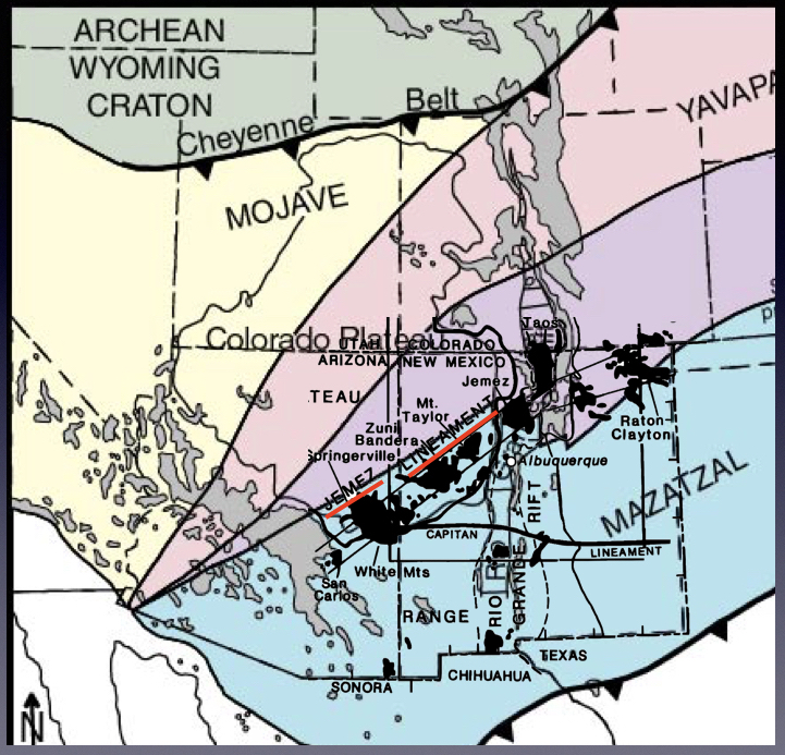
New Mexico is a geotripper’s paradise in general. Landforms are diverse. Rocks range from ancient crust (1.5+ billion years old) to the recent volcanics. Due to a dry climate, vegetation is sparse and plants don't obscure the landscape. Thus we often can make sense of what we see. However, my specific destination is an exception. The Jemez Lineament is one of the most prominent volcanic features in the state, and yet it may be the most mysterious. In 1984, volcanologists Smith and Luedke called it “the most spectacular phenomenon of its kind in the US … and not easily understood.” Thirty years later, their words still apply.
 |
| Volcanic fields of the Jemez Lineament, with Socorro Magma Body added (source unknown). |
The Jemez Lineament is an obvious 800-km line of volcanic fields that spans northern New Mexico—from the Raton-Clayton volcanic field in the northeast corner, to the Zuni-Bandera field near Grants, and on into Arizona. It crosses multiple major tectonic provinces: the Great Plains, southern Rocky Mountains, Basin and Range Province, and Colorado Plateau. Features include cinder cones, lava flows, calderas, maars, shield volcanoes, composite cones, volcanic necks and more. The rocks are relatively young, erupted in the last nine million years. Most are basaltic (the one major exception is the Valles Caldera).
 |
| Capulin Volcano lies near the northeast end of the Jemez Lineament (L. Crumpler; source). |
 |
|
Aerial view of Valles Caldera—so large that it’s hard to grasp from the ground (L. Crumpler; source).
|
 |
|
The Zuni-Bandera field near Grants includes the youngest eruptions in the state, such as McCarty’s flow (view from 20,000 ft; L. Crumpler; source).
|
Early on, some geologists assumed the Jemez Lineament was a hotspot chain—a line of volcanic activity resulting from the continent moving over a hotspot in the mantle. It parallels a line of volcanism to the north in Idaho and Yellowstone, considered by many to be a hotspot trace. However, the Jemez Lineament doesn't fit the hotspot model because there’s no time progression. Younger and older features are lined up in no particular order. [Even though the hotspot hypothesis has been rejected, Wikipedia refers to the Jemez Lineament as the “Raton hotspot trail.”]
Currently, the most popular hypothesis invokes events from the deep past, when North America was a smaller continent. From 1.8 to 1.6 billion years ago (Paleoproterozoic), several large crustal fragments and/or volcanic arcs drifted north and collided with the southern margin of proto-North America, enlarging it by 1500 km in just 200 million years.
 |
|
The American Southwest in the Paleoproterozoic Era (source, modified).
|
The suture between the young continent (aka Wyoming craton, green in map above) and the Mojave and Yavapai terranes is known as the Cheyenne Belt. I live just south of it, and it's nicely exposed in the Medicine Bow Mountains west of town. Very different rocks occur on either side of a narrow zone of contorted rocks mangled during collision; this is the ancient suture. In contrast, the boundary between the Yavapai (pink) and Mazatzal (blue) terranes is “diffuse and elusive” (Magnani et al. 2005). It's considered a broad transition zone (purple in map) where rocks from both terranes are exposed. Even the boundaries of the transition zone are hard to pinpoint; the sharp lines on maps are misleading.
Adding the Jemez Lineament to the map of Paleoproterozoic terranes reveals a seductive pattern (below). The volcanic fields of the Lineament (black blobs) line up with the Yavapai-Mazatzal transition zone! It's tempting to think that crustal collision 1.6 billion years ago is still shaping the landscape. Perhaps the old suture has provided pathways through the crust for magma to reach the surface.
A pre-existing structure shows up in many explanations of the Jemez Lineament:
“magma leaked through the broken crust” (interpretive sign)
“… a zone of apparent crustal weakness geologists call the Jemez lineament” (Price 2010)
“Although there’s no simple answer to this question, clearly the answer must involve some major structural feature deep within the earth’s crust” (Muehlberger et al. 2003).
“Some geologists consider the Jemez lineament to be a reactivated Precambrian suture or boundary; … some structural or tectonic features of the Jemez lineament must penetrate through the crust into the mantle, because the most significant volumes of [Quaternary] volcanic rocks in New Mexico are erupted along this zone (Goff 2009).
“It may coincide with a boundary between Proterozoic lithospheric age provinces (a suture zone), which in effect exerts control on the present-day disassembly of the lithosphere” (Baldridge 2004).Baldridge’s suggestion that the crust is coming apart (“disassembly”), perhaps along an ancient suture, is not just some wacko idea. Much of New Mexico has been undergoing extension for the last 30 million years. The most obvious evidence is the Rio Grand Rift, which has widened to almost 100 km in places (map below; source). Maybe thirty million years of stretching has loosened the Yavapai-Mazatzal suture enough to allow magma to ascend to form the Jemez Lineament.

 |
|
The magic of reflection seismology requires humongous amounts of computer processing time (source (free)).
|
If you go …
Though the state nick-namers have ignored New Mexico volcanism, other agencies give it the attention it deserves. The Bureau of Geology and Mineral Resources, and the University of New Mexico Press have published excellent affordable books for those who want to see and learn about the state’s volcanic features and geology in general (flagged ** in Sources below). In addition, several very cool interactive websites can help you plan your trip: Volcanoes of New Mexico and Virtual Geologic Tour of New Mexico.
Sources (in addition to links in post)
** less technical but full of information, with photos, figures, maps and more
** less technical but full of information, with photos, figures, maps and more
Baldridge, WS. 2004. Pliocene-Quaternary volcanism in New Mexico and a model for genesis of magmas in continental extension, in Mack, GH, and Giles, KA, eds. The geology of New Mexico, a geologic history. New Mexico Geological Society Special Publication 11.
Dunbar, NW. 2005. Quaternary volcanism in New Mexico, in Lucas, SG, MOrgan GS, and Zeigler, KE, eds. New Mexico’s ice ages. NM Institute of Mining and Technology Bulletin 28:95-106.
Dunbar, NW. 2005. Quaternary volcanism in New Mexico, in Lucas, SG, MOrgan GS, and Zeigler, KE, eds. New Mexico’s ice ages. NM Institute of Mining and Technology Bulletin 28:95-106.
** Goff, F. 2009. Valles Caldera, a geologic history. University of New Mexico Press.
Magnani, MB, et al. 2005. Seismic Investigation of the Yavapai-Mazatzal Transition Zone and the Jemez Lineament in Northeastern New Mexico, in Karlstrom, KE, and Keller, GR, eds. The Rocky Mountain Region—an evolving lithosphere: tectonics, geochemistry, and geophysics. (2005), AGU, Washington, D. C.Geophys. Monogr. Ser. 154: 227-238. Free.
** Muehlberger, WR, Muehlberger, SJ, and Price, LG. 2005. High Plains of northeastern New Mexico, a guide to geology and culture. NM Bureau of Geology and Mineral Resources.
** Price, LG., ed. 2010. The geology of northern New Mexico’s parks, monuments, and public lands. NM Bureau of Geology and Mineral Resources.
Smith, RI, and Luedke, RG. 1984. Potentially active volcanic lineaments and loci in western conterminous United States, in Explosive volcanism: inception, evolution, and hazards. Washington DC, National Academy Press, Washington: 47-66.
Fascinating stuff. We were there last summer during our whirlwind trip through the four corners area and back. Thanks for all the information about the volcanic history and the Rio Grande Rift. Have a great trip!
ReplyDeleteThanks, Beth! (stay tuned ;-)
Delete