 |
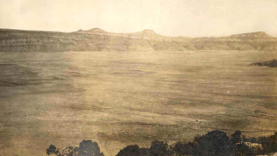
| Paradox Valley, Colorado, USA. Courtesy ArcGIS Online; click to view. |
The elongate northwest-trending structure in the aerial photo above is the
Paradox Valley on the eastern edge of the
Colorado Plateau Province. Notice anything odd? The Dolores River cuts straight across it rather than running the length of the valley as rivers typically do. It was the Dolores’s puzzling behavior that got the valley its name. But there’s a good reason for it: the Paradox Valley is not a river valley; the Dolores River had nothing to do with its creation.
The Paradox is one of a series of narrow elongate valleys in southwest Colorado and southeast Utah that trend northwest parallel to the old Uncompahgre Uplift. The Uncompahgre is part of the Ancestral Rocky Mountains (ARM), another of the paradoxes in this story. The ARM rose during late Paleozoic time, about 320-270 Ma (million years ago), when South America was colliding with North America during the assembly of Pangea.
 |
The Paradox fold and fault belt; the valleys run parallel to the fault bounding the late Paleozoic Uncompahgre Uplift (red arrow). After Gutiérrez 2004.
|
Given the timing, is tempting to conclude that the continental collision to the south caused the uplift of the Ancestral Rockies, but the northwest trend of ARM structures conflicts with our understanding of plate tectonics and intracontinental mountain building. Generally such uplifts form perpendicular to the direction of force. For example during the Laramide Orogeny (70-40 Ma), a crustal plate moving east under the west coast of North America resulted in north-south-trending mountain ranges far inland -- the modern Rocky Mountains. The Laramide Orogeny is considered to be a good model for uplift of the ARM in many ways ... except for orientation. The Ancestral Rockies are aligned roughly parallel to the direction of force from the continental collision to the south ... darn. Their origins remain controversial, with at least four hypotheses currently under consideration.
 |
| The Ancestral Rocky Mountains, after Trudgill 2011. This author attributes ARM deformation to both continental collision along the southern margin of North America and arc collision along the western edge. |
ARM anticlines are associated with adjacent synclines, such as the Paradox Basin (not to be confused with the Paradox Valley), which formed in conjunction with the Uncompahgre Uplift (red arrows in illustration above, click to view). The Paradox Basin includes much of southeast Utah, southwest Colorado, and adjacent New Mexico and Arizona. Downwarping was massive and asymmetric (Barbeau 2004). On the northeast side, the basin drops off steeply from the Uncompahgre Uplift, bounded by a reverse fault. Overall displacement is 2-5 km, and crustal shortening along the fault is estimated at 10 km. On the west side, the basin drops much more gradually.
 |
Schematic cross section through the asymmetric Paradox Basin, vertical scale greatly exaggerated.
From Barbeau 2003. |
The Paradox Basin is not obvious from today's surface, having been buried and deformed in the 300 million years since it came to be. It is defined based on the extent of the sediments that were deposited in it -- the Pennsylvanian Paradox Formation, a cyclical series of strata dominated by evaporites. An idealized cycle is shown below.
 |
| Idealized cycle of evaporites of the Paradox Formation, modified from Fillmore 2010. Notes: Anhydrite is converted to gypsum when exposed. Halite is mineralized NaCl, rock salt, and is referred to as "salt" in this discussion. The potash layer often is missing, with the unconformity above the salt layer instead. |
The Pennsylvanian was a time of global cyclic sea level change, thought to be related to glacial cycles in the Southern Hemisphere. At sea level lows, the deepest part of the Paradox Basin was cut off or nearly so from the surrounding ocean, leading to evaporation (the regional climate is thought to have been arid). As many as 33 cycles of deposition and evaporation have been documented in the deeper parts of the basin, mainly via oil and gas exploratory drill holes (note "black shale rich in organics" in column above).
When the depositional environment changed and no longer favored evaporites, the Paradox Formation was buried beneath marine carbonates and shales, triggering an interesting phenomenon in the salt layers. Under enough weight from overlying sediments, salt becomes plastic and flows towards areas of less pressure. There can be sufficient localized accumulation of salt to uplift overlying strata, producing salt anticlines.
 |
| The Salt Valley salt anticline north of Arches National Park, Utah. Note synclines on either side that formed when salt flowed out and into the anticline between them. The crest has been breached to form a valley. Modified from Fillmore 2010. |
But salt is fickle. If it comes into contact with groundwater, it dissolves and leaves, no longer providing support for the strata above. The anticline may collapse, producing a valley along the former crest, such as the Salt Valley in the figure above and the Paradox Valley below.
There is yet another paradox to consider. The long-standing explanation for these salt valleys has been dissolution and collapse, but certain features suggest regional deformation played at least some role. For example, the Paradox Valley is bounded on both sides by northwest-trending normal faults that don’t fit with strictly local deformation due to salt dissolution and collapse. And all of these salt valleys are elongated in the same northwesterly direction ... doesn't that mean something? Might there be regional tectonic forces at work? Ge et al. (1996) proposed that salt anticline collapse was caused by the mid-to-late Cenozoic extension of western North America responsible for the
basins and ranges west of the Colorado Plateau. Gutiérrez (2004) then responded in support of strictly local collapse. By suggesting that perhaps both were involved, Fillmore (2010) wisely took the middle road.
 |
| Geotripper caught Yellow Line Fever in the Paradox Valley, possibly due to the long northwest-trending walls bounded by normal faults. I hope it doesn't happen to me! |
 |
Paradox, Colorado, in the Paradox Valley in the Paradox Basin, home of the Paradox Formation.
Courtesy Montrose Daily Press (Cox 2008). |
How to Get There
Paradox, Colorado: 38.368646° -108.964189°
 |
| Courtesy Google Maps, click to view. |
[This post is part of a series devoted to upcoming field trips. I welcome suggestions
of other things to see and do in this area, and sources of information.]
Additional Information
Baars, Donald L. 2002. A traveler's guide to the geology of the Colorado Plateau. Salt Lake City: University of Utah Press. Baars provides several road logs through the Paradox Basin, including one in the Paradox Valley.
Barberau, D.L. 2003. A flexural model for the Paradox Basin: implications for the tectonics of the Ancestral Rocky Mountains. Basin Research 15: 97-115. Barbeau argues the Paradox Basin is an intraforeland flexural basin similar to those produced in the Laramide Orogeny, and discusses the odd orientation of the basin and other ARM structures relative to the collision of North and South America, the purported cause.
Cox, Marilyn. 2008. Paradox: Stories of the Wild West. Montrose Daily Press, May 19, 2008. Interesting account of the history of Paradox, Colorado, and its paradoxical valley.
Fillmore, Robert. 2010. Geological evolution of the Colorado Plateau of eastern Utah and western Colorado, including the San Juan River, Natural Bridges, Canyonlands, Arches, and the Book Cliffs. Salt Lake City: University of Utah Press. The Paradox Formation and salt anticlines, as well as the paradoxical Ancestral Rockies, are discussed in detail. Road Log E tours the collapsed salt anticlines of Castle Valley and Moab-Spanish Valley.
Ge, H., Jackson, M.P.A. and Vendeville, B.C. 1995. Rejuvenation and subsidence of salt diapirs by regional extension. Gulf Coast Assoc. of Geol. Soc. Trans. 45: 211-218. The authors argue in favor of a tectonic model, relating collapse of salt anticlines to Cenozoic extension of western North America.
Gutiérrez, F. 2004. Origin of the salt valleys in the Canyonlands section of the Colorado Plateau Evaporite-dissolution collapse versus tectonic subsidence. Geomorphology 57: 423–435. Gutiérrez argues against the tectonic model of Ge et al. (above), favoring strictly local deformation.
Trudgill, B.D. 2011. Evolution of salt structures in the northern Paradox Basin: controls on evaporite deposition, salt wall growth and supra-salt stratigraphic architecture. Basin Research 23: 208-238. Detailed descriptions of salt structures and implications re origins.


