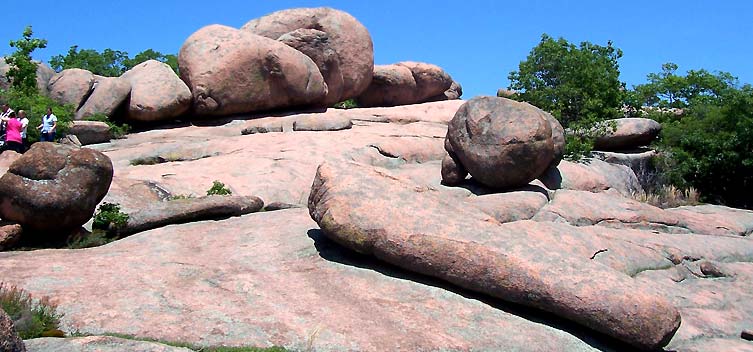
 |
| Tors at Vedauwoo, southeast Wyoming, USA. |
The first geologist to characterize our tors probably was Ferdinand V. Hayden of the US Geological and Geographical Survey of the Territories. In 1870, he led an expedition through Wyoming Territory, first heading north from Denver along the east flank of the Laramie Mountains, then called the Black Hills. He was especially impressed with the “picturesque” massive feldspathic granites of the high country.
 |
| Granite of the Laramie Mountains ("Black Hills"), 1870. WH Jackson photo. |
But Hayden’s opinion and my intuition turned out to be wrong. It is hard to find information about tor geology, especially for the tors of the Laramie Mountains. The Wyoming State Geological Survey offers nothing, nor does the Forest Service, which manages much of the area. An extensive literature search produced two papers on our local tors, both from 1969. Finally, the University library’s copy of Landforms and geology of granite terrain (Twidale and Vidal Romaní 2005) was checked out to faculty until the semester ended (gripe). Instead of a post about the geology of tors, I put together a photo essay with selected tors from around the world, including pink elephants, barns, a favorite wife, several with mystical powers, and some of our locals.
 |
| Pink elephants at Elephant Rocks State Park, Missouri. |
A month ago, I finally had enough material to write about tor formation. The generally accepted theory involves a two-stage process. First, fractured granite is weathered underground to create the sculpted forms -- boulders, stacked rocks, domes. A cover of weathered granite (regolith) builds up over the solid rock, and fills the fractures (grus). Then when conditions are right, for example when the area is uplifted and eroded, the weathered material is quickly removed (geologically-speaking), leaving sculpted rock forms standing above the surface. For a detailed explanation please see the previous post.
 |
| Two-stage process of tor formation; click to view. |
This final post was to be about the tors of the Laramie Mountains, also known as the Crow tors, and would explain one last piece of the story. Why are there are only isolated clusters of tors? Why is everything else eroded away?
 |
| Near Crow Creek, Laramie Mountains (Laramie Council of Industry 1924). |
Alas, there appears to be no clear explanation. Here I summarize what I found, with a promise of pretty pictures afterwards. But first, briefly, the setting.
The Laramie Mountains are typical of uplifts of the Laramide Orogeny, the mountain-building event responsible for the Rocky Mountains. It is a broad-backed anticline with Precambrian igneous and metamorphic rocks exposed at the crest, and younger sedimentary rocks on the flanks. In the southern part of the range, the broad crest is especially prominent. It is underlain by the 1.4-billion-year old Sherman granite, and is called (predictably) the Sherman surface.
 |
| Interstate 80 traverses the Sherman surface on the crest of the Laramie Mountains, and will descend gradually to Cheyenne on relic Miocene topography -- the Gangplank. Vedauwoo tors visible in distance. Courtesy Wyoming DOT. |
Uplift of the Laramie Mountains began in the late Cretaceous, ca 80 million years ago, accompanied by downwarping of the adjacent basins. There were several cycles of uplift and erosion, with the latest uplift in the late Eocene. Subsequently, during Oligocene and Miocene times, sediments eroded off the highlands filled the adjacent basins, eventually lapping high onto the uplift.
 |
| Late Cretaceous - Cenozoic history of a typical Laramide uplift (condensed version). Click to view. After S.H. Knight by way of B. Mears, Jr. (1984). |
Beginning in the late Pliocene, stream rejuvenation, possibly due to epeirogenic uplift, resulted in renewed erosion and exhumation of the old landscape. Virtually all Tertiary sediments have been removed except for a relic patch on the east side of the range near Cheyenne. This is the Gangplank, a remnant of Miocene topography that still laps evenly onto the Sherman surface.
 |
| Cross-section through southern Laramie Mountains; on southeast flank, relic Tertiary strata lap onto Sherman surface (after Mears 1984). Click to view. |
Thus we have the necessary players in tor creation -- fracturing of the Sherman granite with uplift, sufficient time for weathering of the fractured granite underground, and erosion for removing regolith to reveal the sculpted granite, with grus cleaned out of the fractures. But why are tors where they are? Is there something about the Sherman granite that might explain the differential weathering and/or erosion, resulting in isolated tors?
Cunningham (1969) suggested variable fracturing of the granite. Areas of close fracturing would weather more rapidly, with the rock completely reduced to regolith with enough time. The erosion that followed would leave a fairly flat, rolling surface -- the Sherman surface. The flatness of this surface may have been controlled by relic geomorphology -- perhaps a Precambrian peneplane. Smaller tors and boulders represent areas of medium fracturing. Massive domes and walls developed from widely-jointed rock.
 |
| Wall-like tor at Vedauwoo. |
Cunningham provided no evidence for differential fracturing aside from the end results themselves, and made clear that this was a possible explanation only. He described the limited below-ground data available for the Sherman granite. Irregular occurrences of rotted granite to 50 feet thick were observed in a gravel quarry. Alternating layers of rotted and solid rock had been found in a well bore as well.
Eggler et al. (1969) recognized two facies within the Sherman granite in the southern Laramie Mountains. The Trail Creek granite was associated with much of the rolling Sherman surface: “So reliable is this relationship that where Trail Creek granite stops, the Sherman surface stops and is replaced by a more rugged, outcrop-dominated topography.” Several other surfaces developed on this Trail Creek facies were found a short distance south in Colorado. The clusters of tors were associated with what Eggler called the Cap Rock quartz monzonite, as well as other crystalline rock types.
 |
| Tor complex rises above rolling topography of Sherman surface. |
Eggler et al. attributed differential weathering to “extensive high-temperature oxidation of Precambrian age” affecting principally the opaques and biotite of the Trail Creek granite. “Formation of hematite along biotite cleavages expanded the mineral” allowing later weathering to proceed rapidly in comparison with non-altered rock. Alteration in Cap Rock quartz monzonite was “minimal” making it more resistant to weathering.
Igneous petrology is something I know almost nothing about, but that doesn’t keep me from wondering about Eggler et al.’s conclusions. In their analyses they looked only at grus -- so how they can conclude that alteration occurred during the Precambrian, rather than later during long periods of burial with extensive regolith development? Also, if there indeed is significant variation in the Sherman granite with regards to weatherability, how does it compare with the differential weathering of granite above and below ground? Underground weathering can proceed rapidly, and may accelerate as regolith develops (Twidale and Vidal Romaní 2005). If Tertiary fill did indeed lap high onto the granite core of the uplift for prolonged periods of time, perhaps accelerated weathering due to burial was the greater factor in reduction of granite to grus. At highest elevations, some outcrops would have been protected from rapid weathering by virtue of not being buried.

I don’t have enough knowledge to judge the work of Eggler et al., and could find no help in the form of more recent work. Their “Trail Creek” granite is no longer recognized, having been replaced with the provisional "Virginia Dale ring-dike complex" to the south in Colorado. North of the state line the facies, if it is real, is now nameless.
And so we end with the Crow tors almost as mysterious as they were when I started this series. If you-the-reader can offer additional information or ideas, they would be much-appreciated! For now ... let's enjoy the tor landscapes of the southern Laramie Mountains.


No one else was there, aside from the tor creatures ...
 |
| ... we even had our choice of picnic tables. |

Post Script: Whew! this has been the hardest post ever!! I need a plant fix, like the taxonomy of Mexican alcoholic beverages -- coming up next. ¡Salud!
Literature Cited
Mears, B., Jr. 1984. Advanced Geomorphology seminar, University of Wyoming; field trip and class notes.
Cunningham, F. 1969. The Crow Tors, Laramie mountains, Wyoming, USA. Zeitschrift fuer Geomorphologie 13: 56-74.
Eggler, D.H., Larson, E.E. and Bradley, W.C. 1969. Granites, grusses, and the Sherman erosion surface, southern Laramie Range, Colorado-Wyoming.
Laramie Council of Industry. 1924. Laramie and Albany County, Wyoming: the center of southern Wyoming's industrial and recreation area.
Twidale, C.R. and Vidal Romaní, J.R. 2005. Landforms and geology of granite terrain. London: Taylor & Francis Group.
Hi there, sorry, I have a question for you which is actually not related to this post but I didn't know how to contact you... feel free to delete afterwards. :)
ReplyDeleteSo, I'm researching more about mtDNA and learned that plants have the same thing with plastids, which apparently have the same symbiotic origin as mitochondria... fascinating! So, is it somehow correct to say that plastids in plants are as mitochondria as in animals?
Thanks!!
Goodness, I just asked you a stupid question, didn't I, since plants have mitochondria too... Sheesh, sorry!! :)
ReplyDeleteno problem! ... a longer reply is at your post on missing heritability
Deletethanks so much -- I'm working on that post on mtDNA and ptDNA transfer and apparently it's a lot more common in plants... I hope I'll get the plant part correct, if not you'll have to correct me!! :)
ReplyDeleteThank you for your info on Vedauwoo. I am putting together a geology program for Kindergarten-2nd at the library. It is hard to believe that they started out underground. :)
ReplyDeleteCool! glad it was useful.
Delete