Thursday, March 30, 2017

Of Microfungi, Music, Conservation & More

Remembering Martha Christensen.

In 1982, when I started as a grad student in botany at the University of Wyoming, my familiarity with fungi was limited. I knew of only two kinds: mushrooms and yucky crud (like athlete’s foot). But that’s not why I took Mycology. Few botany courses were offered that would fulfill my grad requirements, so when someone told me Mycology was “a really good class,” I signed up. It was a great choice, one that has benefitted me for 35 years.

By the time the semester ended, we had been immersed in the mind-boggling taxonomy of fungi, and exposed to the many critical roles fungi play in plant growth and ecosystem health. We experienced economic mycology: bread, beer (beer in class didn’t raise eyebrows then), cheese, tempeh and more. Especially intriguing to me was the discovery that soil microfungi in Wyoming basins include tundra species! These are Pleistocene periglacial relics, from times not so long ago (circa 10,000 years) when today’s short-grass prairies were permafrost and tundra.

But the best part of Mycology was the instructor, Dr. Martha Christensen. On the first day of class, we were taken in by her passion for the subject and her sense of humor. It was a semester filled with new knowledge, camaraderie, and lots of fun. I went on to take Martha’s Algae and Bryophytes, and was her teaching assistant for Man, Agriculture and Civilization, a non-majors course. I don't remember exactly what was taught in that course, but I’ve thought of it many times in the 30+ years since, because of one very useful piece of advice. We were frantically preparing for lab while the clock raced towards 1:10, when Martha noted with a smile: “This is just like fixing dinner for lots of guests: get as much done as you can, then quit worrying and enjoy it!”

The next year, when my advisor announced he wouldn't be available for my defense and seminar, Martha agreed to serve as committee chair. I’m not sure why I was so lucky, probably just timing, but it felt like Fortune had kindly intervened.

Those grad student days were the start of a long enjoyable friendship. But then last week Martha shocked everyone by passing away. She was 85, but still so full of enthusiasm and energy, and so busy with life, that death was unimaginable. The days since have been a time of reminiscing and sharing stories.

Martha had a long list of academic achievements. When I read her obituary and a recent tribute by one of her colleagues, I realized how little I knew about her career. That’s because our friendship was based on other mutual interests: outdoor recreation, conservation, and music. Martha’s interests were broad, and though an academic, she found time for them all. Sometimes it seems those days are gone. Is academic pressure now too great? Is there no longer time for the arts, public service, advocacy?

Martha played the viola, as do I. I love her story—told with her characteristic hearty chuckle—about how being a violist helped her land a professorship in the Botany Department. She was sure she was hired partly because several faculty members and their wives were fans of classical music and supporters of the University symphony orchestra—which was in desperate need of a good violist. Martha found herself sitting first chair (in a section of three!) and would play with the UWSO for thirty years. Though she loved classical music, and was especially fond of opera, she was no snob. Martha also played the saw!—entertaining us at departmental Christmas parties.

There was another side to Martha that we appreciated very much … and still do. She was a major advocate for public lands conservation in Wyoming, contributing both time and financial support. This is a tough place to be a conservationist; it’s easy to get burned out. But Martha persisted. That she loved nature and the out-of-doors was always clear. In retirement, she took great pleasure in visiting natural areas in the US and other parts of the world, always exploring, always learning. I looked forward to hearing of her latest adventures in our annual Christmas correspondence, for her contagious enthusiasm never disappeared!
Martha was one of the conservationists profiled in Ahead of their Time; Wyoming Voices for Wilderness.

A memorial service for Dr. Martha Christensen will be held on Saturday afternoon, April 1, 2017, at the Heritage Congregational Church, 3102 Prairie Road in Madison, Wisconsin. Family members will greet her friends at 1:00. A service of remembrance will begin at 2:00.

In September (date to be set), Martha's many colleagues, students and friends will gather in Laramie to celebrate her life. More information will be provided on the University of Wyoming Botany Department website.


Thursday, March 23, 2017

Black Hills Montane Grassland Infographic

This picture is worth 620 words! (Click on map and those below to view details.)

When our Black Hills Montane Grasslands paper appeared in the December 2016 issue of The Prairie Naturalist, I was really happy—happy to see it in print after years of work, and happy to see the map in color. I’m so glad South Dakota Game, Fish and Parks was willing to pay the extra $500. We badly needed color to drive home our message … and a clear strong message is the whole point of using an infographic.

But is this really an infographic? … or just a map?

According to the Oxford English Dictionary, an infographic is “a visual image such as a chart or diagram used to represent information or data.” The term came into use in the 1960s, originally as an adjective. Infographics include maps as well as charts, diagrams, networks and such. When a map emphasizes certain features (e.g. with symbols or colors) to show a situation, trend or pattern, it becomes an infographic.

Such maps (also called thematic maps) have been around far longer than the term “infographic.” The first that we know of was created in 1604 by Gerardus Mercator, to show religions of the world. He added symbols to various locations for the predominant religion. There was no need to refer to a list or table, because the viewer could see the situation at a glance (for example, the New World is filled with idol worshippers).
Designatio-Orbis-Christiani; David Rumsey Map Collection.
Part of legend, showing Mercator's choice of symbols.
A more powerful thematic map is one that Abraham Lincoln is said to have spent hours studying—Map Showing the Distribution of the Slave Population of the Southern States. Based on 1860 census data, counties were shaded according to the size of the slave population (darker – larger). A viewer sees immediately which parts of the region were heavily-dependent on slave labor.
Distribution of the Slave Population of the Southern States of the United States; source.
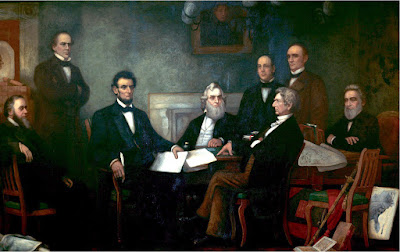
The Slave Population map played such an important role that it was included in the 1864 painting, First Reading of the Emancipation Proclamation of President Lincoln, by FB Carpenter (below, lower right; source).

In general, images are far more powerful than words. They grab our attention, and we process them “with alarming speed.” The brain can interpret a picture on the spot, whereas text must be processed linearly (more here). So if a message is amenable to being communicated with an image, that’s the way to go. A good infographic quickly shows a situation that would require many words to explain. As I worked on the grassland map, I found myself wishing I could skip the corresponding verbal explanation entirely. It would have saved me 620 words!

In creating the grassland thematic map, I had to figure out how to quickly and clearly communicate the message hidden in the massive amount of information we collected:
Black Hills Montane Grassland is a rare and endangered vegetation type endemic (limited) to the Black Hills of western South Dakota and northeastern Wyoming. Only eight mostly-native stands remain. All occur in an area of less than 35 square miles, on public land managed for multiple use. These should be managed as conservation sites.
We had the data to prove it. We thoroughly surveyed the high Limestone Plateau for Black Hills Montane Grasslands, finding 91. We evaluated and ranked each one based on size, vegetation quality (% native species), disturbances, and condition of the surrounding landscape. We found only eight A- or B-ranked grasslands. Only 10.5% of original habitat (based on presence of relic indicator species) now supports native Black Hills Montane Grassland.

After testing various symbol schemes on my colleagues, I settled on colored circles, one in the center of each grassland. Circle size indicates grassland size (three categories). Circle color indicates grassland quality (overall rank). The color scheme is intuitive: circles for the best grasslands are green, those for the worst are brown.
Only eight green and yellow grasslands remain! Fortunately, some are large.
Early on, I tried to come up with an effective black-and-white map to save money. But it was impossible to find symbols that stood out. Colors are much easier for the viewer to distinguish than shapes, which was the other choice for quality. Finally, color grabs the reader, especially in a black-and-white setting (ours is the only color figure in the issue). Fortunately, when our funding agency saw the color map, they quickly agreed color was the way to go.

I recently learned that our grassland thematic map is specifically a proportional symbol map—like Charles Joseph Minard's 1858 map about meat (livestock) sent to Paris butcheries from across France. Minard also used circles of various sizes, in this case to represent amounts of meat. The circles themselves are little infographics—pie charts, with colors representing types of meat.
Source includes much more about Minard’s famous and powerful infographics.

We dedicated our grassland paper to our late colleague and friend, Helen McGranahan (below, in white shirt). Her concern for Black Hills Montane Grasslands, her expertise in grassland biology and management, and her wonderful sense of humor are greatly missed!
Botanists at work in the Black Hills, 2011.

Sources (in addition to links in post)

Marriott, HJ, Faber-Langendoen, D, and Ode, DJ. 2016. Finding the best remaining Black Hills Montane Grasslands, the first step in conservation. The Prairie Naturalist 48:102-105. The paper will be available soon (and free) at The Prairie Naturalist archives. In the meantime, email me (see Contact tab), or download here (paste into browser bar): file:///Users/hollismarriott/current%20work/BHMG/BHMG2016/0PNATfinalrevision/BHMGMarriott%20102-105.pdf

Cartography and Visualization. PennState Department of Geography. If I had found this site before I started working on my map, it would have saved me a lot of time!

The power of pictures. How we can use images to promote and communicate science. James Balm, BioMed Central blog. (“We process images at an alarming speed.”)


Wednesday, March 15, 2017

Books from a Land of Rocks

All photo-poetry montages by Hollis (click to read). Thank you, poets, for your words.

The Grand Valley, in western Colorado, is a land bounded by rock. To the north, the Book Cliffs stretch for almost 200 miles—sinuous bands of muted sandstones and shales. To the south stands the steep face of the Uncompahgre Plateau—red, yellow, buff and orange sandstone walls, on a foundation of dark ancient rock. And in between—in the community of Fruita, just off the roundabout near the west end of town, on the second floor of the old bank building—eponymous Lithic Press makes words into books and sends them off, dispersing poetry across the Southern Rocky Mountains and Colorado Plateau (in this land of rock, we find ourselves using physiographic provinces rather than political subdivisions).

First off the press was Whacking the Punchline, a small square spiral-bound collection of compression sketches by Jack Mueller, published in 2008. Since then, 27 more books—many in custom format—have been ushered into the world. Lithic recently joined a national trend of small independent presses opening brick-and-mortar bookstores. They hung out their shingle in 2015.
Lithic’s shingle features predatory Xiphactinus—“probably the most photographed fossil specimen in the world” (click on photo to view the smaller fish inside; source).
Lithic Bookstore & Gallery—a space for design, sales, poetry readings, contemplation, inspiration.
Danny Rosen, at the office.
Last September, I stopped in Fruita to enjoy the local literary scene, as I do most years. This time I cornered Lithic-owner Danny Rosen in his office. “I have some questions for you” I said firmly, swinging a six-pack for emphasis. We sat down for an interview.

How did the name Lithic Press come about?
The name stems from my background in geology; the word means stone-like or pertaining to stone. Also, it alludes to early methods of printing. Lithography involved spreading a greasy kind of ink onto etched limestone to print from one medium to another.

What kinds of books does LP publish—what subjects, genres?
So far, Lithic has published books of poetry—largely because that has been my interest. I would like to publish other genres in the future, like natural history. More than any particular subject matter, I want to work with writers who pay attention to language, tell intriguing stories, teach me something.

What’s your policy on manuscript submission?
We do not accept unsolicited manuscripts; we accept manuscripts largely by invitation. I had an open submission period last year for chapbook manuscripts (simple books, folded and stapled, 20-40 pages long). We received over 100 submissions. It was time-consuming to go through all of them, and unpleasant to send out so many rejections. I don't anticipate doing that regularly. But we did get a few books out of it.

Though we don’t advertise for submissions, they show up anyway … frequently. Seems everyone who ever wrote a poem wants a book. Maybe that's a reflection of “celebrity culture.” Being a publisher offers interesting viewpoints on human psychology! Recently we've been reaching out to writers we admire, asking for manuscripts. This year and next we have books coming out by writers in North Carolina, South Carolina, Oregon, New York, California, and Bombay.

What is the Lithic bookmaking process?
I facilitate the process. One way or another I find manuscripts (or they find me). I don't edit so much as closely read each manuscript to find errors and give suggestions. The books I've done for Jack Mueller required a lot of work, a labor of love. He's a close friend, and this friendship played a big part in the creation of Lithic Press. I wanted to publish his work—I love it so much and I think it has great value. Amor Fati took four years to complete.

Most of our books start with manuscripts that are fairly polished when we receive them—that’s what I want. My strength is to make books for strong writers, not to help make writers strong. The early phases can be very exciting, when the idea first turns into a concept of an artifact. We decide what the book will look like: size, shape, kind of paper and binding type, font and font size, and so on. Kyle Harvey does all the design and layout for Lithic. He is very talented and imaginative. I nudge him continually, to be open to what possibilities we may conjure: new kinds of paper, different presentations.
The making of a book presents possibilities at every juncture, on every page, like Jack Mueller’s The Gate, which we made as both an inexpensive chapbook and as a limited edition, cloth-bound, foil-stamped hardcover. For Kierstin Bridger's Demimonde, a book of poems written from the point of view of prostitutes in frontier mining towns in Colorado, we paired antique images with each poem and printed them on paper vellum pages.

I want every book to stand alone as a fine artifact—a handsome object that feels good in the hand, that makes a contribution to the human story—a little something to spread around, leave behind.
I’ve been fascinated with books all my life. As a kid, I was blown away by “All the Books in the Library.” To make something that will go into that library feels like important work. Someone said to me recently that I was like a midwife to the book. That’s a strange but accurate description. It’s awesome to hold a newborn book and usher it into the world.
Going Down Grand, Lithic’s pocket-sized book of poems for your next trip down.


Yet stones have stood for a thousand years, and pained thoughts found 
The honey of peace in old poems.
–Robinson Jeffers

Saturday, March 11, 2017

Tree-following: Wildlife

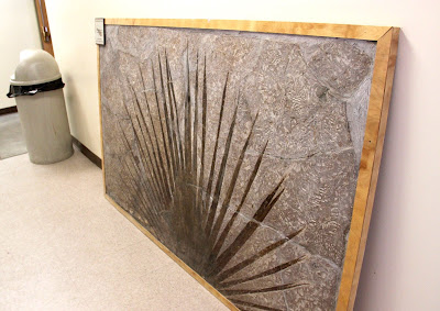
Sabalites in the hallway to the University of Wyoming Geology Museum.

We tree-followers have gathered once again to report on the status of our trees, the ones we’ve chosen for the year. Mine is a Sabalites palm tree that grew in southwest Wyoming 50 million years ago, and then went extinct. It must have been common around ancient Fossil Lake, and fairly close to shore, because many intact frond fossils have been found in lake sediments now turned to rockthe Green River Formation.

I won’t visit Sabalites in its native habitat until it's warm enough for an outdoor vacation, and our local Sabalites, on display in the Geology Museum, doesn’t change from month to month. So what to report? Sometimes tree-followers write about wildlife seen on or near their trees; this month I’ll do the same.
Knightia and Sabalites. Courtesy CSMS Geology Post.
My wildlife sighting was a school of Knightia, small herring-like fish. They were swimming around a large Sabalites frond that was floating in warm subtropical water near the lushly-vegetated shore of Fossil Lake. But wait … there’s something wrong with this idyllic scene. The fish weren’t swimming … they were dead!
Mass mortality slab, University of Wyoming Geology Museum.
How ironic that mass die-off was preserved in exquisite life-like detail! (NPS photo; click to view).
Fossil Lake occupied the southwest corner of Wyoming early in the Eocene Epoch.
Fossil Lake was the smallest of the large Eocene lakes of southwest Wyoming and adjacent states, yet it’s exceptional in terms of the number of Knightia fossils it left behind. In some “death layers” there are 100+ per square meter—over an area of tens of thousands of square meters! Millions of Knightia fossils have been excavated—it’s the most common fish fossil in the world! In 1987, it was designated the state fossil of Wyoming.
Most common vertebrate fossil or fish fossil? Both claims are out there.
The Fossil Butte Member of the Green River Formation includes many mass-mortality layers, representing multiple events scattered across thousands of years. Apparently die-offs were not rare catastrophes, but something that occasionally happened under specific conditions. But those conditions remain a mystery. Maybe fish were poisoned by cyanobacteria, or suffocated by super-blooms of algae, or killed by changes in water temperature or chemistry or both. Maybe Knightia was especially susceptible. Its modern-day relatives, the herring, are known to die off en masse in response to sudden environmental change. Fortunately herring recover quickly—one fish can lay 200,000 eggs at a shot! Maybe Knightia was equally fecund.

Knightia had more than environmental change to worry about. Given its abundance, it probably was the main food for predator fish, like Diplomystus dentatus below. This fossil is not from a mass mortality bed, so what killed it? “It most likely died from starvation or suffocation because it could not spit the Knightia out” (NPS).
Did Diplomystus' dinner do him in? (NPS photo; click to view the remarkable preservation).

For more tree-following news, check our virtual gathering. And consider joining us ... it's amazing what we learn when we follow trees. There's always something interesting, and never any pressure or obligation :-) Thanks to The Squirrelbasket for hosting!


Sources  (in addition to links in post)

Grande, L. 2013. The lost world of Fossil Lake. University of Chicago Press.

National Park Service. Geology Field Notes, Fossil Butte National Monument.

Virtual Museum of Geology. Green River Formation.


Sunday, March 5, 2017

In Search of Layered Pond Muck

There's a story here.

We were making slow but steady progress up the narrow valley of Libby Creek, across unvegetated hummocky ground covered in boulders and snow, through a network of cold sediment-laden creeklets. But just as we caught sight of the snout of the glacier ahead, we were stopped by icy torrents emerging from the fractured dirty ice. Water came roaring down the canyon, rolling and bashing boulders. It was only June, but the onset of melting had opened tunnels and drainages in the ice, and the annual flood was underway.

We headed back, stopping at one of the ponds among the hummocks of glacial till, where we ate lunch perched on quartzite boulders above the cold wet ground. The pond was mostly ice-free, the water murky with sediment carried in by streams. I tossed a penny into the pond—not for a wish, but to confuse future glaciologists.

Then my ice age dream vaporized and I was back in the aspen stand, staring at layered dirt.
From gravel pit near Barber Lake, 1972; photo by Wayne Sutherland, pencil for scale (Mears 2001).

Learning geology is learning to read ... not books, but landscapes, rocks and dirt. Like books, they take us into other worlds—even the far distant past. But the entryways aren’t always obvious. For example, few people would stop to examine the drab dirt slope in the photo above.

That photo has appeared in several publications about the geology of the Medicine Bow Mountains of southeast Wyoming. The outcrop was said to be located just west of Centennial, which is just 30 miles from where I live. Of course I wanted to see it, so I read the description carefully.
“… recession of the ice in the broad canyon west of Centennial left hummocky till behind. Trapped meltwater created a pond here which is recorded by thin varves of sand and pebbles washed in during summers, and silts that slowly settled when the pond’s surface was frozen. The varves, now exposed in an old gravel pit near Highway 351 [Barber Lake Road], are overlain by till of a second advance.” (Mears 2001)
Medicine Bow Mountains during the Pleistocene. Arrow marks location of pond sediments exposed in an old gravel pit. Diagram and drawings by SH Knight (1990).

I drove the Barber Lake Road from top to bottom, searching for an abandoned excavation, but found nothing. Then I checked around the various campgrounds … still nothing. Maybe it’s gone, I thought—buried, eroded away, or turned into a campsite. After all, 45 years have passed since that photo was taken.

But I didn’t give up. Instead, I did what any wise person would do: I asked a librarian, specifically the Centennial librarian 
The librarian didn’t recognize the layered dirt in the 1972 photo, and didn’t know of an old gravel pit near Barber Lake, but she did know several people who might well know, and indeed one of them did know: “just off the Willow campground road near the entrance gate, on the left.”

A week later, I parked near the campground gate. Through aspen trunks, I spotted a promising pale outcrop and headed over for a closer look. Yes! This was the old gravel pit, now overgrown with aspen. Even after 45 years of weathering and erosion, layers were still distinct in places, though not as fresh as in the old photo.

Gerard De Geer of the Geological Survey of Sweden was the first to figure out the stories told by what Swedish geologists called hvarfig lera (layered clay), now called “varves.” Varves are like tree rings. Each one represents a year of activity—growth in the case of tree rings, and sedimentation in the case of varves. De Geer constructed the first varve chronology, published in 1912. Since then, the Swedish Varve Chronology has grown into a 14,000-year record of floods, drought, rains of volcanic ash, deglaciation, plants (pollen), and more.

The varves in the Medicine Bow Mountains date to roughly 10-15,000 years ago, when the crest of the range was covered by an ice cap, and a glacier extended down the Libby Creek drainage. During the warm season, streams from the glacier brought down sediment—more or less depending on the amount of melting and vigor of the streams. Some of the sediment ended up in ponds in the moraine and hummocky till (unsorted sediment) below the glacier. After a short “summer,” the ponds froze over. Then the finest particles slowly settled out, forming a thin band of clay on top of summer sediments. Gravel quarrying exposed part of the varve record of one of these ponds.
A layer is a year’s worth of sediment. Arrows point to clay bands marking end of annual cycles.
Do thinner varves above the thicker one tell of less melting and sedimentation? Or was the glacier farther away, melting back to the high country? Our chronology is too short to say. We need more varves, probably a lot more.

More than once I’ve wondered if rocks and dirt are as easy to read as their stories in print suggest, but rarely can I judge. However, in this case I know there's another version of the story. The great Samuel H. KnightMr. Geology of Wyoming—concluded that the varves formed in a moraine-dammed lake rather than in a pond in hummocky till.
“Accumulations of unsorted rock fragments transported by ice were deposited in moraines on valley floors, behind which lakes were impounded in which distinctly laminated, fine-grained sediments (varves) were deposited.” (Knight circa 1974, published 1990)
Libby Creek terminal moraine and impounded lake, in which varved sediments were deposited. Cross section shows relationships of various glacial sediments (Knight 1990).

Whether deposited in ponds or lakes, surely more varves lie hidden under today’s soil and plants. So hikers and mountaineers, keep an eye out. Among all those lodgepole pines and grouseberry bushes, there may well be entryways to other worlds!

Some climb mountains “because they are there”
Others climb mountains their secrets to share,
For mountains hold in their massive grasp,
Profound records of the infinite past. 
– Samuel H. Knight


Sources

Thanks to Deb and Lowell for directing me to the varves.

Knight, SH. 1990. Illustrated geologic history of the Medicine Bow Mountains and adjacent areas, Wyoming. Geological Survey of Wyoming Memoir 4. PDF

Mears, B, Jr. 2001. Glacial records in the Medicine Bow Mountains and Sierra Madre of southern Wyoming and adjacent Colorado, with a traveler's guide to their sites. Geological Survey of Wyoming Publ. Info. Circ. No. 41. PDF