Showing posts with label New Mexico geology. Show all posts

Monday, May 14, 2018

The Mailbox on the Sill—the short & the long of it

The Palisades in Cimarron Canyon, northern New Mexico.
Browsing through my photos of the Cimarron Canyon Palisades, I spotted an odd form on the crest which I hadn’t noticed when I was there. Is that really rock? Zooming in showed nothing to suggest otherwise. But how improbable!
I’m hardly the first to spot this weird finger of rock. Years ago someone thought it odd enough to add to the Devil’s collection of landforms and landmarks—Devil’s Postpile, Devil’s Backbone, Devil’s Thumb, Devil’s Racetrack, Devil’s Marbles, Devil’s Gate, etc. In this case, we have the Devil’s Mailbox.
Devil’s Mailbox; Pomona Public Library, Frasher Foto Postcard Collection, 1938.
Unfortunately, the Mailbox story ends here, as my “research” (Google) produced no further details. In contrast, the story of its context is much longer, on the order of 40 million years. The Mailbox is part of the Palisades sill, a massive sheet of igneous rock intruded into sedimentary strata of the Cimarron Range. This may have happened during creation of the range, part of the Laramide Orogeny, the mountain-building episode that built the Rocky Mountains. In a later episode of uplift, maybe 20 or 30  million years ago, the Cimarron River cut down through the range revealing part of the sill, in cross-section. The dramatic exposure is called the Palisades, and is part of Cimarron State Park. There’s a convenient pullout at the base, along US Highway 64.
Actually, the details are still being debated.
As of 2002, geologists were still debating the exact age and composition of the sill. Dating has produced ages ranging from 35 million years to as young as 26 million. Rock composition also has been hard to pin down (see this page for citations):
“Based on mineralogy and chemical composition, the Palisades consist of biotite-diorite porphyry. Other geologists have called the rock type of the Palisades a monzonite porphyry, quartz monzonite porphyry, dacite porphyry, a granodiorite porphyry, or a transition from trachydacite to dacite. Although these terms describe the rock properly according to its composition, some terms are inconsistent with its texture. Therefore, the term porphyritic dacite seems the best description of these sills.”
The rock looked porphyritic to me, i.e., large phenocrysts in a matrix of fine-grained rock. This is easy to see in the blocks lining the pullout.
The columns and towers of the exposed sill are spectacular. They're separated by long vertical joints that formed as the intruded magma cooled, underground. Later, water seeped into the fractures, and froze and expanded in winter, slowly breaking the rock. This went on for millennia, producing talus slopes at the base (and rock blocks for the pullout).
Talus slope at base, apparently stable enough for trees to grow large. 
The Palisades Sill Official Scenic Historic Marker is on US Highway 64 in Cimarron Canyon State Park, about 8.3 miles east of Eagle Nest and 15.5 miles west of the town of Cimarron (36.537449° -105.152374°). The Mailbox stands near the northwest end of the ridge visible from the highway.

Sources

The Palisades sill is included in New Mexico’s Virtual Geologic Tour, a terrific trip-planning resource. The Cimarron Canyon State Park page includes a substantial list of references.


Friday, April 20, 2018

In Search of Iridium & the Smoking Gun

Is this the smoking gun?
Or this? (Western Ghats, Deccan Large Igneous Province; source)
Probably you’ve heard about the meteorite that killed off the dinosaurs, but just in case you haven't … it hit the Earth (Yucatan Peninsula) 65 million years ago, sending massive amounts of debris into the atmosphere. Major climate change ensued, so quickly and dramatically that many species (not just dinosaurs) were driven to extinction. The ejected debris included iridium from the meteorite itself—the “DNA” that “solved” the crime. It rained down on Earth forming a thin layer now exposed at sites around the world—the iridium layer or anomaly. What a terrific story! So much of drama!! And it solves what used to be a hugely challenging and vexing puzzle.

Or maybe not. When I visited the iridium site at Raton, New Mexico, I already knew the story wasn’t so simple; probably many readers do as well. But the meteorite-as-dino-killer story lives on, understandably. The mind-boggling horror is irresistible: “NIGHT OF THE DINOSAURS … the end of the Dinosaur Age on planet Earth”!!!
“Iridium Layer marks End of Dinosaur Age on Planet Earth” is not a B-movie title; it’s the lead on a faded interpretive sign.
However, it's possible that the smoking gun is not the famous iridium layer (1) but rather extensive thick basalt flows in west-central India—the Deccan Large Igneous Province (Deccan Traps). Covering more than 500,000 sq km, it’s one of the largest LIPs in the world (Mukherjee et al. 2016). Like the Yucatan meteorite crash, these eruptions took place about 65 million years ago, roughly concurrent with dinosaur extinction. Volcanism on that scale likely ejected enough material (and possibly iridium) to cause significant climate change, perhaps leading to dino demise. Even more intriguing, the Yucatan meteorite impact may have caused the massive volcanism (see Sources below for more details).

There also are complicating factors regarding the scale and timing of extinctions. For example, some dinosaurs already were in decline, some survived (the birds), and not all life forms were affected. Maybe climate-changing meteorite-caused massive volcanism exacerbated challenges already faced by species in decline. Or maybe there’s another surprising puzzle piece waiting to be discovered! In any case, the iridium layer is worth a visit … nothing wrong with a little mystery in the drama.
“What minor evils might arise from the contact [impact] were points of elaborate question. The learned spoke of slight geological disturbances; of probable alterations in climate, and consequently in vegetation …” Edgar Allen Poe, 1839 (2)
The iridium site at Raton, New Mexico is just north of town, a short distance up a winding paved and gravel road passable to cars. In addition to the famous anomaly, there’s a picnic table and great views.
Town of Raton below Raton Mesa—note basalt cap on horizon.
The iridium layer is exposed on a short steep bank next to the IRIDIUM LAYER sign. I say “exposed” rather than “visible” because I wasn’t sure I found the actual layer. Neither of my guidebooks offered specific guidance. The interpretive sign was much more helpful, though some words were illegible:
… a thin clay-like layer—just above the level of the IRIDIUM LAYER sign … 8 inches beneath the coal layer … weathers to a fine white powder. This layer consists of melted rock (glass since altered to clay) blown out of the impact crater (asteroid). High concentration of iridium and shocked minerals … suggesting “not of this planet” (3)
According to the interpretive sign, the iridium anomaly lies in the narrow layer between the grayer rocks from late Cretaceous times, the “final period of the dinosaurs,” and the early Tertiary tan rocks above, from the “Era of Mammals” (the early part of the Tertiary is now called Paleogene). Is that a minor fault offsetting the layer mid photo?

Back at home, I searched Google images for help. Sure enough, I’m not the only one who has had trouble finding the iridium layer. One amateur geologist who visited the well-known site near Trinidad, Colorado (about 20 miles from Raton) went so far as to have backscatter scanning electron microscopy (BSEM) and chemical analyses done on what he thought was clay from the iridium layer, only to learn there was no iridium. As he explained, the distinctive clay layer (kaolinite) he sampled marks the Cretaceous-Tertiary (Paleogene) boundary, but “the iridium I’ve since learned isn’t actually concentrated in the clay layer itself but in the 2 layers directly above it (red arrows in photo): that is the impact layer (smectite - blue arrow in photo), and the 2-inch coal layer directly above that.

He also noted that kaolinite “is thought to result from the altering of volcanic ash beds in acidic coal swamps, but in this case it’s the result of a doomsday shroud of impact material interacting with a coal swamp.” But do we know? Maybe it’s altered volcanic ash after all.
Source (used for personal, educational purposes).
“I was at the right place and was able to identify the boundary layer, I just didn’t have all the facts. But at least I’ve learned something from my mistake, so it turns out not to be such a bad thing. And now you’ve learned something, too.” anonymous amateur geologist on scienceBuzz

Notes

(1) Whatever the cause, the K/T boundary at the Raton site marks environmental change, for it's defined by the disappearance of Proteacidites pollen. At Sugarite State Park nearby, a spike of fern spores occurs just above this boundary, and has been interpreted as “opportunistic fern species replacing the normal plant community that was devastated by the extinction event.” (Paul Bauer, p 262 in Price 2010)

(2) Poe was referring to a comet that destroyed life on Earth, as described by one of the dead. See The Conversation of Eiros and Charmion.

(3) Actually, iridium is of this planet, especially “in molten rock deep within.” High concentrations of iridium could be evidence of large-scale volcanism (source).

Sources

Cowen, R. No date. The K-T extinction. UC Berkeley. http://www.ucmp.berkeley.edu/education/events/cowen1b.html

Muehlberger, WR, Muehlberger, SJ, and Price, LG. 2005. High Plains of northeastern New Mexico, a guide to geology and culture. NM Bureau of Geology and Mineral Resources.

Mukherjee, S, et al. 2016. Tectonics of the Deccan large igneous province: an introduction. Geological Society, London, Special Publications 445: 1-9. http://sp.lyellcollection.org/content/445/1/1

PBS.org. No date. What killed the dinosaurs? http://www.pbs.org/wgbh/evolution/extinction/dinosaurs/volcanism.html

Price, LG (ed). 2010. The geology of northern New Mexico’s parks, monuments, and public lands. Socorro: New Mexico Bureau of Geology and Mineral Resources.

Sanders, R. 2015. Did dinosaur-killing asteroid trigger largest lava flows on Earth? Berkeley News. http://news.berkeley.edu/2015/04/30/did-dinosaur-killing-asteroid-trigger-largest-lava-flows-on-earth/


Friday, April 6, 2018

Tilted Rocks & the Abyss of Time

“I rejoiced at my good fortune in stumbling upon an object so interesting to the natural history of the earth …” James Hutton, 1788
Me too, James!

On a cool sunny day, almost a year ago now, I drove down the valley of the Dry Cimarron River in northeast New Mexico. On either side were rock walls—brown, red, yellow and almost white sandstones and mudstones, earthy and rich against the bright sky. They were neatly stacked in horizontal layers—not so different from several hundred million years ago, when they were still beds of sediment.

But then I came upon Steamboat Butte (1), with its rocks askew! Here was an example of the “object” that had brought such great joy to James Hutton 230 years ago—an angular unconformity. Underneath a cap of horizontal sandstone were tilted redbeds.
Whenever I see an angular unconformity I also see, in my imagination, a hand-waving geologist expounding on its creation, interpreting the story told by the rocks. But on that day, all I had was a rather laconic guidebook, which intoned: “The underlying Triassic Travesser Formation was tilted and eroded before the overlying Jurassic Entrada Sandstone was deposited.” I had hoped for more—I wanted to “rejoice” and “grow giddy” looking into the deep abyss of time! So when I returned home, I consulted with two men famous for profound geological insights that stemmed in part from their study of angular unconformities—Nicholas Steno and James Hutton.

Nicholas Steno—anatomist, pioneering geologist, bishop, saint (Wellcome Collection).
Nicholas Steno worked in the Tuscan part of the Apennine Mountains in the mid 1600s, initially studying fossils. He was barely a geologist, but that was only because in his day geology was still in its infancy. Steno came up with some of our most basic geological principles, which he published in 1679 in his Prodromus. It was to be a brief introduction to a lengthy dissertation on geology, paleontology and more, but he never wrote it (2). Still, there was enough in the Prodromus to start a revolution in thinking about Earth history.

At that time, it was widely believed that when God made the Earth, it was pretty much as it is now. The land has been eroded, that can be seen. But erosion is far too slow to have much impact. Steno concluded otherwise—that the Earth had changed significantly, and would continue to do so, as God intended. He had found convincing evidence, most famously seashells on mountaintops.

Steno also saw evidence of change in tilted sedimentary rocks, which began as sediments deposited in water, i.e., as horizontal beds (his principle of original horizontality). Given that they’re now "at an angle to the horizon", something must have happened. But what? Steno attributed tilting to collapse of rock layers into a large cavity. He described this interpretation in the Prodromus, with cross-sections and a brief summary. “Here I shall only reckon up in short the order of the change” (for details, readers were referred to the promised dissertation).

Steno's description proceeds from past to present. Figure 25 shows a seafloor with “beds yet entire, & parallel to the horizon.” In 24, a vast cavity has been “eaten out by the force of Fire and Water, without any breach in the upper Beds.” Eventually the upper Beds collapse (23), creating a valley with tilted rocks on either side.
In the valley, now filled with seawater, “new Beds” form (22). Fire and water again eat out a cavity (21), and the upper Beds collapse (20). But this time, the breach reveals old tilted beds below the horizontal new Beds—an angular unconformity!
Broadly-speaking, Steno’s explanation is similar in many ways to today’s thinking, and was remarkable given the paucity of geological knowledge then. Collapse of large cavities is no longer accepted, yet modern thinking does incorporate collapse of rock beds in some cases, though not as a separate step. Rocks are too weak to form superior beds over a huge cavity; instead, they collapse as land is being downwarped (Alvarez 2009).
Steno would say the redbeds collapsed into a cavity before the red-and-white sandstone above was formed.

James Hutton—chemist, gentleman farmer, pioneering geologist (1776, source).
In 1787, James Hutton was walking along the Jed Water in the Scottish Borders, his eyes glued to the rocks. At Inchbonny, he was stopped in his tracks:
“I was surprised with the appearance of vertical strata in the bed of the river, where I was certain that the banks were composed of horizontal strata [italics added]. I was soon satisfied with regard to this phenomenon, and rejoiced at my good fortune in stumbling upon an object so interesting to the natural history of the earth, and which I had been long looking for in vain. … Here the vertical strata, similar to those that are in the bed of the Tweed, appear; and above those vertical strata, are placed the horizontal beds, which extend along the whole country.”
Hutton had found an angular unconformity! (he called it a junction). His friend John Clerk made a drawing, which appeared in Hutton’s Theory of the Earth (1788).
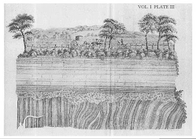
Hutton’s Unconformity at Inchbonny, drawn by John Clerk (source).
After studying multiple exposures of the junction, Hutton came up with an explanation. The vertical beds, which he called the schistus, were marine sediments turned to rock, due to pressure and heat. The seafloor was heaved up to form land, tilting the beds, which were “laid bare” (eroded) into a roughly flat surface. Then the land subsided, and another cycle began (3). Now the sand-stone was deposited, and again the seafloor was heaved up and laid bare. But this time, erosion revealed the schistus/sand-stone junction (4).

However, there was a major problem with this story. The processes Hutton invoked—deposition, uplift, erosion—were much too slow. To complete the two cycles needed to create and reveal the junction would require an immense amount time, far more than the 4000-6000 years said to be the age of the Earth. But Hutton was not one to be constrained by dogma. He concluded that the Earth was far older than people thought; the schistus–sand-stone junction (now called the Hutton Unconformity) was proof. It was Hutton who introduced the concept deep time, critical to geology. With deep time, even a very slow process can produce major change.
Hutton’s Unconformity at Siccar Point; gently tilted sand-stone above near vertical schistus (source).

Two centuries have passed since Hutton described the junction he found in the Scottish Borders. Yet his interpretation of angular unconformities is very much the same as today’s: the lower rocks were tilted, and then buried in sediments that would become the upper rocks … as in the case of Steamboat Butte.

Like the schistus, the Travesser redbeds began as sediments, though in a lake most likely. The resulting rocks were tilted when the region was uplifted (5), and were sheared off (“laid bare”) by erosion. Sediments accumulated atop the redbeds—in this case, massive amounts of sand deposited by wind to form a giant erg (sand sea). The erg became the Entrada sandstone; a remnant now caps Steamboat Butte. We can see this unconformity because the Dry Cimarron River has cut down far enough to reveal it.
The angular unconformity at Steamboat Butte is far younger than Hutton’s, but it still provides the thrill and joy of peering into deep time. In fact, to describe the experience we would need to modify only slightly the words of John Playfair—Hutton's friend who accompanied him to Siccar Point:
“We felt necessarily carried back to a time when the redbeds on which we stood were as yet the surface of the land, and when the sandstone before us was only beginning to be deposited in the shape of sand dunes, fashioned by the wind ... The mind seemed to grow giddy by looking so far back into the abyss of time!”
Stop and read the rocks—so much to learn, such joy to be had!

Notes

(1) Steamboat Butte is sometimes called Battleship Mountain.

(2) Shortly after the Prodromus was published, Steno abandoned geology, devoting the rest of his life to the Catholic Church. He died in 1686, and was beatified in 1988.

(3) Hutton considered the Earth to be in a steady state maintained by elevation and erosion—a series of cycles with “no vestige of a beginning – no prospect of an end”.

(4) Hutton’s “schistus” is now known to be Silurian sandstones and shales (433 Ma). The “sand-stone” is today’s Devonian Old Red Sandstone (370 Ma) (Prothero 2018).

(5) The timing of Travesser redbeds tilting is unclear; apparently it wasn't associated with mountain-building. The Ancestral Rocky Mountains (circa 300 Ma) predate the redbeds, and today’s Rockies (Laramide Orogeny, circa 70-50 Ma) are younger than the sandstone. Muehlberger et al. (2005) refer only to a “pre-Entrada fold”. Parker (1933) reported numerous such folds in the Dry Cimarron area.


Sources

Alvarez, W. 2009. The Mountains of Saint Francis; discovering the geologic events that shaped our earth.

Baldwin, B., and Muehlberger, W.R. 1959. Geologic studies of Union County, New Mexico. New Mexico Bureau of Mines & Mineral Resources Bulletin 63.

Cutler, A. 2003. The Seashell on the Mountaintop. A biography of Steno emphasizing his pioneering contributions to geology and paleontology.

Hutton, J. 1788. Theory of the Earth. Transactions of the Royal Society of Edinburgh, 1.

Muehlberger, WR, Muehlberger, SJ, and Price, LG. 2005. High Plains of northeastern New Mexico, a guide to geology and culture. NM Bureau of Geology and Mineral Resources.

Open University provides a clear interesting account of Hutton’s geology.

Parker, BH. 1933. Clastic plugs and dikes of the Cimarron Valley area of Union County, New Mexico. Journal of Geology 41: 38-51.

Prothero, DR. 2018. The story of the Earth in 25 rocks. Columbia University Press.

Steno, N. 1671. The Prodromus to a dissertation concerning solids naturally contained within solids. Laying a foundation for the rendering a rational account both of the frame and the several changes of the masse of the Earth, as also of the various productions in the same. English translation


Friday, February 23, 2018

Capulín Volcano, Inside and Out

Capulín cinder cone, with lava flow (left) from a vent at the base of the cone.
On the west edge of the Great Plains in the northeast corner of New Mexico, at the northeast end of the mysterious lineup of volcanic features known as the Jemez Lineament, stands Capulín Volcano. It’s one of the youngest in the Raton Volcanic Field, having erupted just 60,000 years ago. Erosion has not yet destroyed its beauty, and much rock remains exposed, revealing some of its life story.
Capulín displays its beautiful symmetry.
Capulín's partially-vegetated lava flows are fascinating to explore.

Capulín is a cinder cone, a common and simple type of volcano. In shape, construction and composition, it very much resembles Paricutín in central Mexico, which erupted in a farmer's field just 75 years ago. Scientists were on hand to observe and describe Paricutín, from its birth in 1943 to its final gasp in 1952. Because the present is the key to the past, we can infer much about Capulín’s life from this modern-day example.
The infant Paricutín, just two days old. The cone is already 30 m tall (source).
Paricutín in the prime of life (1943; source).
Dead Paricutín, in 1997; note flow from side vent, a boca (source).

Now back to Capulín. Earthquakes probably were the first signs of imminent birth. For weeks they grew in intensity, until an “especially violent tremor” opened a fissure that spewed steam and smoke, followed by glowing red magma. These first stage eruptions were relatively calm—lava oozed and flowed.
Black line marks extent of a first-stage lava flow, later covered by cinders and now grass (Sayer & Ort 2011).
But it wasn’t long before all hell broke loose. Gas-rich magma exploded upon reaching the surface, producing tall “fiery fountains” of fine volcanic ash, coarser cinders, and even bombs!—some weighing hundreds of pounds. Debris from repeated eruptions accumulated layer by layer to form a cinder cone more than 1500 feet tall. The road to the summit of Capulín crosses great exposures of layered volcanic debris. Unfortunately, there's no place to pull over before the parking lot at the top. However, the road is closed to traffic at the end of the working day and open to walkers.
Pale gray ash, coarse cinders and small bombs from the violent second stage of Capulín activity.
Large dark volcanic bomb, with medium dog for scale.
The Capulín crater is asymmetric, presumably because more debris accumulated downwind. It’s wonderfully accessible, with trails to the bottom and around the rim.
Source.
View into crater from trailhead.
Crater floor.
View north; prominent volcano on left and lava-capped mesa with snow in distance.

As gas was depleted, the dramatic eruptions subsided, giving way to a third stage of activity. No longer gas-propelled, magma couldn’t reach the top of cone, and instead flowed out vents on the sides, called bocas. (Spanish for mouth). These flows are the freshest of Capulín’s remains, still only partially vegetated. Two trails and the picnic area provide fine opportunities to examine the “rocky desolate wasteland.”
Lava flows from Capulín and its neighbors (from Sayer & Ort 2011).

I saw plants colonizing rock everywhere I went. Some of the older flows appear mostly vegetated from a distance, but up close they're still rather rocky—just try walking across.
Partially vegetated flow along Lava Trail; Sierra Grande (volcano) on skyline.
Darker rocky tongue in grassland is an earlier lava flow (but post-cinder cone).
Gooseberry (Ribes sp.).
Young fringed sagebrush (Artemisia frigida).
Capulines on the crater rim. Capulín is the Spanish name for several wild cherries. The species in northern New Mexico is Prunus virginana—the chokecherry.
Flow surfaces cooled first, hardening into crust. But lava continued to ooze beneath, occasionally pushing through the crust to form tumuli or squeeze-ups. Some nice ones can be seen from the road to the park and along the lower trails.
Squeeze-up on Visitor Center Nature Trail.
Another tumulus, on the Lava Trail.
One more, near park entrance; vegetated lava flow in distance.
Not surprisingly, the Boca Trail tours the boca that was the source of Capulín’s final lava flows. The trail is relatively new—wear tough shoes and watch for trail signs.
Tastefully subdued sign (click on image to view).
This flat area is considered the remains of a lava lake, one of several in the Boca Trail area.

Geologists think Capulín was active for only a few years, but its life hasn't been dated precisely, only narrowed down to sometime between 62,000 and 56,000 years ago. Cinder cones typically are short-lived, erupting until they become clogged. Then they're done; they don't lie dormant. The Raton Volcanic Field probably is still active, but if Capulín’s magma source builds to erupt again, it will have to start all over, with another fissure spewing steam and smoke.
Baby Capulín is close by. Its lava covers parts of Capulin’s youngest flows, thus Baby is indeed younger.
A small part of the Raton Volcanic Field, viewed from the flank of Capulín.


Sources

Muehlberger, WR, Muehlberger, SJ, and Price, LG. 2005. High Plains of northeastern New Mexico, a guide to geology and culture. NM Bureau of Geology and Mineral Resources.

Parent, L, McCristal, J, and Mathis, A. 1991 (and 2006). Capulín Volcano National Moment. Western National Parks Association (recommended; for sale at the Visitor Center, $3.95).

Sayer, WO, and Ort, MH. 2011. A geologic study of the Capulín Volcano National Monument and surrounding areas, Union and Colfax Counties, New Mexico. New Mexico Bureau of Geology and Mineral Resources. PDF