Showing posts with label glaciation. Show all posts

Sunday, August 4, 2024

Missouri River, South Dakota's Great Divide

"What does the Missouri mean to you?" I was asked.
South Dakota is one of those roughly rectangular states in the heartland of the USA. The Missouri River runs through it north to south, dividing it into two nearly equal but very different halves. To the west landscapes are mostly rugged and sparsely vegetated. To the east they're subdued and covered in plants. So after pondering the sign's question, I decided that was what the Missouri meant to me—South Dakota's Great Divide.
Modified from this map; original source not given.
The difference can be seen even from afar: brown west of the river, green to the east (Google Earth, modified).
The contrast west and east of the Missouri has long intrigued those travelers who pay attention. In 1839 Joseph Nicollet, surveyor with the US Corps of Topographic Engineers, led an expedition up the river as far as Fort Pierre, and then northeast by land. They experienced a dramatic change in landscape almost immediately. The "Great American Desert" west of the river was gone. Instead ...

"... the vast spaces opening to your gaze, the astonishingly richer vegetation, the smoother undulations breaking the monotony, the purity of the water in the streams and rivers flowing into the Missouri, the nature of the woods shading them—everything proclaims a favorable change in the physical aspects of the country." (Nicollet 1843)

Why the sudden change? It can't be moisture. Precipitation does increase going east but only gradually. And there's no significant change in elevation, nothing to disrupt South Dakota's gentle downward slope from the Rocky Mountains eastward. But there is a huge difference in substrate, as Nicollet noted:

[Land east of the river] "is covered by a species of deposite of the kind for a long time known by the name of diluvium; but as this word implies a theoretic idea as regards the accumulation of such deposites, the cause of which is still open to controversy, it is now very generally abandoned, and the designation of erratic deposites, among others, adopted in its stead. I have, therefore, used the latter expression, as comprehending a vast deposite of sand, gravel, pebbles, and clays, ... and masses of rocks transported to a distance from their original position, usually called erratic blocks."

Nicollet's "vast deposite" east of the Missouri is fine ground-up material rich in plant nutrients, with "erratic blocks". Farmers call it "boulder clay". Photo courtesy Dave Rintoul.
In the above description, Nicollet alluded to a controversy surrounding these deposits. In fact, it was a raging debate. Similar material in Europe had long been attributed to the Biblical Flood, but some geologists were pushing a radical new idea—glaciers! After all, these kinds of deposits were associated with modern-day glaciers in the Alps. Even so, most geologists considered the "glacial theory" complete nonsense. Ice sheets at lower elevations in Europe? or on the plains east of the Missouri River? Ridiculous! Nearly three decades would pass before climate change, ice ages and continental glaciers were widely accepted (1).
The Missouri is the west boundary of land once glaciated. But why? (modified from Johnson & Knight 2022).
It's very hard to imagine massive sheets of ice covering eastern South Dakota, especially on a torrid summer day. But they did, and multiple times. Starting about 2.6 million years ago, glaciers advanced south from the Arctic six or seven times, sometimes reaching as far as Kansas and Missouri. Advances alternated with interglacial periods, when the ice melted back. In South Dakota the last ice melted just 11,000 years ago (Gries 1996; Johnson & Knight 2022).

As it flows, a glacier grinds and planes the land and carries off the fragments in its base, making it even more abrasive. When it melts, it leaves behind thick deposits of ground-up material—Nicollet's "erratic deposites", now called ground moraine. After multiple advances and melting during interglacials, eastern South Dakota was covered in ground moraine—the source of the fertile soils east of the Missouri River.

Nicollet's "astonishingly richer vegetation" east of the Missouri River was mostly tall grass prairie. But now it's largely gone, replaced with crops.
Some readers may be wondering, as I did: Why are there glacial deposits east of the Missouri but not to the west? Did the river block the ice? That explanation is tempting, but there's a better one. Look at the map below for clues.
Major streams of South Dakota; modified from Gries 1996.
In the late 1850s and again in the late 1860s (before and after the Civil War), Gouverneur K. Warren of the US Army Corps of Engineers studied the Missouri River and its tributaries. In his 1869 report he described the extensive glacial deposits ("drift") and explained why they stopped at the Missouri, why there were none farther west.

"I have determined the south western limit of the glacial drift action to be the Missouri river ... From the Missouri river to the Rocky mountains, over a space varying from 300 to 500 miles in width, no drift is found ... There, then, on that limit a river must have been formed to carry away the melting water from the glacier, and this limit was the Missouri river, and that was the river formed thereby. It cut along this glacial limit because all the streams west of it came from the mountains toward it, down the inclined plain, and there their old course was terminated" [italics mine].

Many years later, USGS geologist Richard Foster Flint agreed with Warren. "The belief, advanced as early as 1869, that an ice sheet flowing southwestward blocked these valleys and detoured the drainage so as to form the Missouri River is confirmed." As evidence, Flint described three anomalous features of the Missouri (two can be seen in the map above). First, it doesn't follow the gradual decrease in elevation west to the east. In fact it flows mostly south, perpendicular to regional slope. Second, its valley generally is steeper-walled than those of its tributaries, indicating youthfulness. Finally, distribution of its tributaries is very lopsided—all major streams enter from the west (Flint 1955).

In summary, the glacial deposits covering eastern South Dakota end at the Missouri River because that was the limit of glacial advance. But glaciers didn't stop there because of the river. In fact there was no river until ice blocked east-flowing streams, sending them south along the margin of the ice sheet to become part of the longest river in North America—the great Missouri, 2546 miles in length from its headwaters in the Rocky Mountains to its confluence with the Mississippi (2).

President Thomas Jefferson by Rembrandt Peale, 1800 (source).
The Louisiana Purchase was one of Jefferson's greatest accomplishments.
In December of 1803, the United States bought the Missouri River from France as part of the Louisiana Purchase. For only $15 million ($18 per square mile) the young country doubled in size. Six months later, in May of 1804, the Corps of Discovery led by Meriwether Lewis and William Clark started up the Missouri from its confluence with the Mississippi. They had been commissioned by President Jefferson to explore, survey and document the new territory—including its plants, animals, useful resources and human inhabitants. But above all, they were to determine whether the Missouri was part of a water route to the Pacific Ocean.

Travel up the swift-flowing river was terribly slow and arduous. The men paddled, sailed and too often pushed or pulled their boats, including a heavy metal-framed keelboat. (It was sent back down the river from their winter camp, with collections, reports and a map.) It's thought that each boatman ate on the order of nine pounds of meat per day! Fortunately game was abundant (Johnson 2022).

The Corps of Discovery reached the Pacific Ocean in November of 1805, but only after leaving the headwaters of the Missouri, crossing the continental divide, and traveling months by foot and canoe to the Columbia River and on to the coast. Clearly the Missouri did not offer a water route to the Pacific. Even so, it would be an important transportation corridor ... in spite of its treachery.

Navigating Old Misery; from exhibit at USACE Lewis and Clark Visitor Center.
The Missouri, or "Old Misery", was notorious for its unpredictability and lurking hazards. Here's how Joseph Nicollet described his trip on the steamboat Antelope.

"But, notwithstanding the great skill with which the navigation of our boat was managed, and the high power that propelled it, our voyage was sometimes interrupted for weeks, owing to the numerous obstacles presented by the river. It would seem that a Missouri pilot ought to possess not only a quick sight, but an intuitive perception to discover through its turbid waters the channel which yesterday had no existence, presents itself today, and will most probably change tomorrow." (Nicollet 1843)

Hazards included sand bars, snags, and wrecked boats. An estimated 400 steamboats were sunk or otherwise destroyed on the Missouri; the average lifespan of a steamboat was five to seven years (Johnson 2022).

Snags (sunken trees) on the Missouri; by Karl Bodmer c. 1839–1840 (source).
Wrecked steamboat on the Missouri; USACE.
Even after trains and trucks largely replaced boats for transport, the Missouri remained a dangerous river. Large floods were common, causing widespread damage to communities and farmland. But times have changed; the Missouri has been tamed. Between 1933 and 1963, six large dams were built on the river in South Dakota, North Dakota and eastern Montana to provide flood control, irrigation water, hydroelectric power and recreation. About 75% of the river's length in the Dakotas is now reservoir water (Johnson 2022).

In terms of storage capacity Lake Oahe is the largest reservoir on the Missouri. From Oahe Dam near Pierre, SD it extends upstream 100+ miles as the crow flies (modified from Google Earth).

Lewis and Clark Expedition, 150th anniversary issue, 1954 (source).
On a hot day near the end of my trip, I walked four miles sometimes shaded by cottonwoods but usually not and often accompanied by dust and flies, and stood on the bank of a free-flowing stretch of the Missouri River. Why? Because the Missouri means more to me than I first thought.

Memories had been surfacing of a little girl and her younger brother playing Lewis and Clark long ago. Those legendary explorers had struggled up the Missouri, enduring summer heat and mosquitos, surviving winter cold and food shortages, all the while not knowing what lay ahead, what discoveries awaited! Lewis and Clark captured our imaginations, and for me they still do. We lived far from the Missouri then, but now I had a chance to travel where they had traveled, to see the great river flowing as they had.

I started from the parking lot of the Adams Homestead and Nature Preserve north of the Missouri River in the southeast corner of South Dakota. The route followed dirt roads and was well signed. You can tag along on this aerial photo (modified from Google Earth).

Early on we passed Mud Lake, the remains of a meander in the Missouri River before it was tamed (3), and continued past fields being tilled. Then there was a handy rest stop, with a water tub that my field assistant enjoyed in spite of all the flies on her ears (a photo would have been rude). I tried rubbing mosquito repellant on her head—it worked!

A short distance further we reached a viewing platform on the bank of the mighty Missouri.
View downstream. One of the Missouri's nicknames is Big Muddy because its sediment load is huge! (4)
As directed, I looked across the Missouri into Nebraska. Much of the river's broad valley bottom is cultivated but this area looked abandoned, in both the photo below and the previous Google Earth view.
Looking south into Nebraska. The forest in the distance is the valley wall.
Artsy abstract photo for my memory collection :)
Once home I opened the Map of Lewis and Clark's Track, Across the Western Portion of North America to locate the spot where I had visited the free-flowing Missouri. The Corps of Discovery traveled this stretch in late August 1804 after burying Sergeant Charles Floyd, the only death on the expedition (perhaps due to a ruptured appendix). His grave is labeled on the map—Floyds Grave.
From Map of Lewis and Clark's Track. Floyds Grave is right of arrow tip marking my visit (click image to enlarge). Courtesy David Rumsey Map Collection.

Notes

(1) For more about the raging flood vs. glaciers debate and Nicollet's involvement, see Mssr. Nicollet & I consider Glacial Theory and Glacial Beauty in South Dakota.

(2) At their confluence, the Missouri River is longer than the Mississippi River (upstream). By convention the longer river retains its name. Why did the Missouri lose out to the Mississippi? See discussion here.

(3) Nearby McCook Lake (in the upper part of the aerial photo) also is an abandoned meander but is older, being shown on a map dated 1895. Perhaps it's a natural one.

(4) Construction of dams and levees drastically reduced the amount of sediment carried by the Missouri River, to 1% of what it had been (Johnson 2022). Even so, it continues to deliver more than half the silt emptied into the Gulf of Mexico! (more here)

Sources (in addition to links in post)

Flint, RF. 1955. Pleistocene geology of eastern South Dakota. Geol. Surv. Prof. Paper 262.

Gries, JP. 1996. Roadside Geology of South Dakota. Mountain Press Publ. Co.

Johnson, WC. 2022. The Missouri River. Chapter 10 in Johnson & Knight 2022.

Johnson, WC, and Knight, DH. 2022. Ecology of Dakota Landscapes; past, present, and future. Yale University Press.

Nelson, Mike. 2014, Jan 29. Geology: eastern South Dakota in CSMS Geology Post. I also thank Mike for directing me to Flint's 1955 paper.

Nicolett, JN. 1843. Report intended to illustrate a map of the hydrographical basin of the upper Mississippi river. US Senate, 28th Congress, 2nd session, no. 237. BHL

Warren, GK. 1869. General considerations regarding the physical features of these rivers: US Army, Corps of Engineers, Rept. Chief of Engineers, 1868, p. 307-314. Full report online. (Conflicting years are puzzling but real.)

Thursday, February 23, 2023

Glacial Beauty in South Dakota

"[The Coteau des Prairies] is a most beautiful tract of land, diversified by hills, dales, woodland, and lakes; the latter abounding in fish" (Joseph Nicollet, 1843).
In the late 1830s cartographer Joseph Nicolas Nicolett, recently arrived from France, surveyed the great triangle between the Missouri and upper Mississippi Rivers. He found the landscapes novel, as did French explorers before him. They "were so forcibly impressed with this novelty in the appearance of the topography, that they employed new names to designate it ... Coteau des Prairies, Coteau des Bois, Hauteurs des Terres, and rolling, flat, or marshy prairies" (all Nicollet quotes are from his 1843 Report).
Nicollet's survey area; annotated excerpt from 1969 USGS topographic map.
During his surveys Nicollet studied and described the local geology as best he could. Unfortunately he was hampered not just by his own limited knowledge but by that of geology itself, still very much a young science. A case in point was the "erratic deposite" (obs. sp. of deposit) he inevitably found immediately beneath the soil—jumbled accumulations of sand, gravel, pebbles, clay, and most curious, rounded boulders from afar.

When we left Nicollet last month, he was preparing a report to accompany his map. He devoted an entire section to Erratic deposites—"species of deposite of the kind for a long time known by the name of diluvium; but as this word implies a theoretic idea as regards the accumulation of such deposites, the cause of which is still open to controversy ... I have, therefore, used the latter expression [erratic deposites]". Thus Nicollet managed to avoid a raging debate then underway. But not for long.

These deposits had long puzzled geologists. Why were they a jumbled mix of type and size, unlike the nicely stratified alluvium of streams and lakes? How did immense rocks travel so far? The widely-accepted explanation was the Diluvial Theory, which invoked a global flood—the Hand of God—to answer such difficult questions.
"How vast must have been the impulsive force which could carry such enormous masses ... deposited for the surprise of the geologist or the contemplation of the thoughtful!" (Figiuer 1863) (1)
But revolution was in the air. Geologist Louis Agassiz was pushing the Glacial Theory, arguing that during glacial epochs ice from the north advanced far south and mountain glaciers flowed to lower elevations. This is why we now find glacial features—striations, polish, jumbled deposits, and such—far from any ice.

In the spring of 1843, the Association of American Geologists and Naturalists held its fourth annual meeting. Among subjects discussed was the highly controversial drift (American term for erratic deposits). A committee of experts had been assembled the year before, Nicollet among them. Now each would share his findings and conclusions.

In the Abstract of the Proceedings (AAGN 1843), we see that even expert geologists were unable to escape the thinking of the times. Glacial epochs and ice sheets reaching far south were impossible (!) and therefore useless in explaining the drift. A Dr. C. T. Jackson set the tone: "Many eminent men incautiously embraced the new theory, which within two or three years from its promulgation, has been found utterly inadequate, and is now abandoned by many of its former supporters. This was the glacial theory of the celebrated Agassiz of Switzerland." [emphasis mine]

Nicollet spoke next, unscripted. The Abstract shows the strength of his opinion: "Mr. Nicollet then rose and addressed the meeting at considerable length and with great animation on Jackson's paper just read, and in opposition to the glacial theory of M. Agassiz. He expressed his astonishment that M. Agassiz should have entirely overlooked the labors of his predecessors in the same field, and particularly of M. De Saussure, who spent forty years in investigating all their phenomena, and had nearly exhausted the subject."

Oddly, Nicollet also stated that a glacier couldn't possibly "score and furrow the rocks in its path" due to the grotto-like passageways beneath it (2). Surely he knew better, having grown up in the Alps. But we must keep in mind that Nicollet was a very sick man. Several days later he was unable to present a paper he had prepared; a colleague read it for him. He died that September. In his small library, his friends found Agassiz's Etudes sur les glaciers (1840). Was Nicollet in his right mind when he opposed the Glacial Theory? Was he too weary to resist the anti-Agassiz fervor?
Nicollet probably had been ill for several years when he died in 1843, at age 57. 

Diluvialism would hold its supporters captive far longer than now seems reasonable. In fact decades would pass before ice ages were fully accepted (Hanson 1970). But finally, glacial evidence became too abundant to ignore. Consider South Dakota, for example.
Glaciation in North and South Dakota; modified from Johnson & Knight 2022.
Of the many people who speed across South Dakota every day, I bet few if any think of glaciers. Yet half the state was covered in ice multiple times, and not all that long ago. The great Ice Age, the Pleistocene, lasted from c. 2.5 million to just 11,700 years ago (source). It was not a single event but a series of glacial and interglacial episodes.

In a sense that ice is still with us, for it profoundly shaped the land, creating undulating terrain, fertile soils with foreign boulders, high coteaus covered in ponds and lakes, and a dramatic change in landscape east and west of the Missouri River, itself a product of ice. These were the things I had come to see.

Like Nicollet, I started my tour of eastern South Dakota near Fort Pierre on the Missouri River. Much had changed of course. Fort Pierre is gone (not to be confused with nearby Pierre, the state capital). Some would claim the Missouri is gone as well, flooded by Lake Oahe. "The astonishingly richer vegetation" described by Nicollet east of the river is almost entirely gone, replaced with fields of corn, wheat, soybeans, and sunflowers. Yet glacial features are still apparent and in some cases more so, thanks to satellite imagery, high tech mapping, and rock pickers.
From Shaded Relief Maps of South Dakota, SDGS; labels added.
On a good relief map, South Dakota's distinctive drainage patterns are obvious. In the unglaciated west, tributaries flow east into the Missouri River. But east of the river there are no tributaries to speak of, only a few southerly-flowing streams. This is a recent development. Just 150,000 years ago or so, streams west of the river continued east in valleys now buried in glacial drift. And there was no Missouri River except for a stretch in the southeast corner of the state (Gries 1996).

The Missouri likely was born mid-Pleistocene, during the Illinoian Stage when all of eastern South Dakota was glaciated. Advancing ice blocked east-flowing streams, diverting them south and east along the ice sheet margin. This new stream apparently was quite powerful, for it cut a channel 300–700 ft deep—enough that the river stayed put when the ice melted away (Gries 1996).

From the Missouri, I drove east across a seemingly endless patchwork of cultivated fields. These too are glacial products—the fertile soils of eastern South Dakota started with ice.
Somewhere in eastern South Dakota; courtesy Google Earth.
A massive sheet of flowing ice easily fractures the surface below, mainly via freeze/thaw cycles. The resulting debris is "plucked" by the glacier and frozen into its base, enhancing the giant rasp and grinder. When the ice sheet melts, it drops its baggage—the diluvium, erratic deposites, and drift of geologists past. Today's geological term is glacial till, or more specifically, ground moraine. Farmers call it "boulder clay".

The till in eastern South Dakota is thick—c. 40 ft on average, and in some places exceeding 500 ft. It's composed mainly of fragments of local bedrock, mostly shale. This explains the clay in " boulder clay". But what about the boulders?
Glacial erratics as riprap, Lake Oahe.
The abundant boulders of eastern South Dakota are composed of granitic, metamorphic, and occasionally very hard carbonate rocks—very different from local bedrock. These are travelers from the North Country, "glacial erratics" transported by ice from somewhere in Canada (Bluemle 2016).

As Nicollet noted, "this deposite always occurs between the vegetable soil and the rocky strata [bedrock] ...", i.e., mostly buried and out of sight. But as I drove past ag fields there was no need to seek out cut banks, gravel pits, construction sites, and such to see glacial erratics. Rock-picking farmers have made them easy to spot. "Nearly every farm north of the Missouri River in eastern South Dakota can point to its very own small mountain of rocks left scattered across the area by glaciers" (from Man Turns Rock Piles Into Big Business).
Rock pile with Brewer’s blackbird, north of Stanley, North Dakota. Photo by Dave Rintoul.
"Folks who first wanted to farm these prairies had to remove the rocks before they could plow, and still have to do that regularly. Winter cold and spring thaws heave buried boulders to the surface every year, and 'picking rocks' is an ongoing pastime for Dakota and Montana farmers. Mechanized pickers with inspired names like Rock-o-matic, hauled behind tractors, replacing the horses, wagons, and manual labor of the pioneer era, make this task easier nowadays." (from Dave Rintoul's Letter to America)

Excerpt from map of Lewis & Clark expedition. Coteau des Prairies upper right, labeled "High Land covered with Wood called Mountain of the Prairie" (source).
About 130 mi east of the Missouri River, I left the low country and arrived at my destination—the Coteau des Prairies. The literal translation of "coteau" is "hill", but in this region a coteau is not a hill. It's a long broad upland topped with hummocky topography. Nicollet thought "plateau" more appropriate, but French explorers had first viewed it from the valley to the east—"looming as [if] it were a distant shore, suggesting for it the name of Coteau des Prairies."

The Coteau extends south to north roughly 200 mi through eastern South Dakota and into North Dakota. It reaches a width of c. 70 mi and rises 600+ ft above the lowlands of the James and Minnesota Rivers. The crest is a mix of grassland, woodland, and lots of water—wetlands, ponds, and lakes—which surprised travelers new to the country. Why are lakes abundant high on the Coteau when the valleys below have so few?
Re-I-Paha, head of the Coteau des Prairies; Nicollet often used local names. Note the many lakes. Source.
View from crest of Coteau des Prairies, Minnesota River lowlands in distance.
Hiking in hardwood forest on the Coteau; glacial erratics in foreground.
Since Nicollet's time, geologists have made good progress in understanding features left by continental glaciers. But the Coteau des Prairies remains a challenge. It was obviously shaped by glaciation, for it's covered in glacial till. But why does it suddenly rise hundreds of feet above adjacent lowlands?

Some geologists think the Coteau was sculpted millions of years before the Ice Age, during major episodes of erosion, especially during mid Miocene time (17 to 15 million years ago). Much of the prominent erosional topography of western South Dakota was created then—buttes, escarpments, and badlands (Gries 1996). Surely such features also were present in the east (same bedrock) ... until they were ground down by glaciers and buried under thick layers of till.

Perhaps the Coteau des Prairies was a preexisting topographic feature too substantial for ice sheets to remove or bury entirely in till. "Before glaciation, the Prairie Coteau was probably an outlier of Cretaceous sandstone standing above a surrounding shale surface" (Bluemle 2016). Flint (1955) considered it "a bedrock feature and the main form has not been obscured by the irregular blanket of drift that mantles it."
 
Slim Buttes in northwest South Dakota. Did the Coteau des Prairies look like this before the ice arrived?

And what about all those lakes and ponds ... ?
Lakes on Coteau des Prairies (dark greenish); lowlands upper left and right (Google Earth).
Apparently ice sheets sometimes flowed up onto the Coteau des Prairies, where they were "stranded and abandoned", forming massive dead-ice moraines 
(Bluemle 2016). When the ice melted, thick layers of till were left behind (3). Buried in the till were huge blocks of ice. When these finally melted, perhaps several thousand years later, water-filled depressions were left behind—today's abundant wetlands, ponds and lakes. They remain as beautiful today as they were in Nicollet's time.
Evening on Pickerel Lake, where Nicollet camped three nights in 1839.

Notes

(1) Look closely. This image of the Deluge shows massive rocks being carried by icebergs—a modified diluvial theory promoted by geologist Charles Lyell (Hanson 1970).

(2) Passages with flowing streams do form beneath glaciers, but the ice can still "score and furrow the rocks". Also, some sources incorrectly state that Nicollet described glaciers as "hollow" at the base; the AAGN Abstract shows otherwise.

(3) Bluemle (2016) hypothesized that when glaciers advanced up the steeper escarpments of the Coteau, internal stress caused shearing in the ice, loading it with large amounts of rock and sediment from below. This would explain the thick till atop the Coteau.

Sources

AAGN (Assoc. Amer. Geologists & Naturalists) 1843. Abstract of the Proceedings of the Fourth Session. Am. J. of Science & Arts 45:310–352 (Nicollet's remarks p. 323). BHL

Agassiz, L. 1840. Etudes sur les glaciers. Smithsonian Libraries.

Bluemle, JP. 2016. North Dakota's Geological Legacy. North Dakota State University Press.

Bray, E., & Bray, MC. 1976. Joseph N. Nicollet on the plains and prairies: the expeditions of 1838–39, with journals, letters, and notes on the Dakota Indians. Minnesota Hist. Soc.

Figuier, L. 1863. (Bristow, LH, ed. 1872). The World Before the Deluge. See p. 425 for proof of a deluge in northern Europe. Project Gutenberg

Flint, RF. 1955. Pleistocene geology of eastern South Dakota. Geol. Surv. Prof. Paper 262.

Gries, JP. 1996. Roadside Geology of South Dakota. Mountain Press Publ. Co.

Hansen, B. 1970. The early history of glacial theory in British geology. J. Glaciology Published online by Cambridge University Press.

Johnson, WC, and Knight, DH. 2022. Ecology of Dakota Landscapes; past, present, and future. Yale University Press (reviewed here).

Nelson, Mike. 2014 (Jan 29). Geology: eastern South Dakota. CSMS Geology Post.

Nicolett, JN. 1843. Report intended to illustrate a map of the hydrographical basin of the upper Mississippi river. US Senate, 28th Congress, 2nd session, no. 237. BHL

Tuesday, January 24, 2023

Mssr. Nicollet & I consider Glacial Theory in northeast South Dakota

Courtesy NASA.

During my visit to northeast South Dakota last fall, I bumped into the great surveyor Joseph Nicollet and discovered we had similar goals. As aspiring geologists we hoped to expand our knowledge of the discipline. We wanted to see and understand the magnificent Coteau des Prairies. And we both struggled to picture today's prairies buried under a thick sheet of ice, though for different reasons.

Thanks to some deep memory, I knew eastern South Dakota was once glaciated but had given the subject little attention. In contrast, glaciation (or rather its possibility) was of great importance to Nicollet, but he didn't know what to think. It was very difficult to accept on such a scale. Our contrasting reactions were understandable given our visits were 183 years apart.
Nicollet Tower near Sisseton, SD. I "met" Joseph Nicollet in the interpretive center at the base.
In 1832, at age 46, Joseph Nicolas Nicollet left France for reasons unclear—perhaps political, perhaps financial, or perhaps because he had become passé, démodé. Though widely recognized as one of the best astronomers and surveyors in the country, his skills were no longer in demand. Much of France had been adequately mapped. This was not the case in the United States. Most of the young country remained only nominally surveyed. Existing maps often were unreliable.

To Nicollet, the opportunities were obvious. Even before he departed for the US, he had decided he would survey and map the great triangle between the Mississippi and Missouri Rivers, as far north as Lake Superior—a region of French influence and French speakers. Seriously, monsieur?! How will a slightly-built, well-educated and cultured but penniless Frenchman survive in this wild unsettled territory? Mais qu'importe; he would make it happen.
Portrait of Joseph Nicolas Nicollet, date unknown (source).
Nicollet's area of interest; annotated excerpt from 1969 USGS topographic relief map.
In 1835, Nicollet was in St. Louis, at the confluence of the Mississippi and Missouri, campaigning for a survey of the upper Mississippi. He secured the support of the American Fur Company (always eager for better maps), and the wealthy Choteau family—fur traders and merchants. The next year he traveled by steamboat to Fort Snelling, and from there, surveyed the upper Mississippi drainage by canoe with Ojibway and French-speaking halfbreed guides. Back at Fort Snelling, Nicollet refined calculations of latitude and longitude from his celestial observation data, and produced a map of the territory he had covered. When he returned to Washington DC, he found that news of his excellent map had already arrived.

Among other things, Nicollet fixed errors made 30 years earlier by Army officer and explorer Zebulon Pike. Most egregious was Pike's erroneous placement of the mouth of the Crow Wing River, off by 27' latitude. As a result, everything upstream was too far south and west, contracting "the extensive region between the Mississippi and the Missouri; so that there was not (so to speak) room for the intermediate territories which I had explored." (This and all Nicollet quotes below are from the 1843 report accompanying his map of the upper Mississippi drainage).

Recognizing Nicollet's skill and zeal for accuracy, the US government, through the Army Corps of Topographical Engineers, funded additional survey, and provided an assistant—a young officer just 25 years old named John C. Frémont, the future Pathfinder. It was an excellent investment. Nicollet would lead two expeditions in the upper Mississippi drainage, determine latitude and longitude for some 90,000 points, and produce Hydrographical Basin of the Upper Mississippi River, the first accurate map of the region.
Excerpt from Nicollet's map, published after his death in 1843; blue labels added.

The first expedition, in 1838, went well enough that Nicollet was able to secure funding for a second, to areas farther north, including Devil's Lake (in today's North Dakota) and the intriguing Coteau des Prairies. On April 4, 1839 Nicollet, Frémont, and botanist Charles Geyer left St. Louis aboard the American Fur Company's steamboat Antelope, bound for Fort Pierre 1270 miles upstream. The Missouri was very low and they repeatedly ran aground, sometimes waiting several days for the water to rise. But there were benefits. Whenever the Antelope was firmly stuck, the scientists went ashore in search of discoveries.

Nicollet would climb banks and slopes above the river to study exposed rock layers, often fossil-rich. He hoped to assign them to the stratigraphic classification used in Europe. Intriguingly, east of the river, at the top of slopes where the land flattened, he inevitably found not layered strata but jumbled accumulations of gravel, cobbles, and even large boulders, all derived from rock unlike any in the area. These kinds of deposits—unstratified and distantly derived—had also been described in Europe, where they were called diluvium or erratic deposites (old spelling of deposit).

After 69 days the Antelope finally reached Fort Pierre, on the west side of the Missouri. It had rained heavily the night before, and water was surging off the largely barren land into the river. The wet clay-rich soil was so slimy, soft and sticky that it was impassable, even on foot. Nicollet noted in his journal that travelers reported similar conditions extending far to the west—lands "so sterile that they are referred to as the Great American Desert."

Yet just across the river to the east, the landscapes changed dramatically: "the vast spaces opening to your gaze, the astonishingly richer vegetation, the smoother undulations breaking the monotony, the purity of the water in the streams and rivers flowing into the Missouri, the nature of the woods shading them—everything proclaims a favorable change in the physical aspects of the country."
The "astonishingly richer vegetation" east of the Missouri has been largely replaced with cultivated fields.
After 18 days at Fort Pierre preparing for prairie travel, Nicollet and his party headed northeast. He found the country beautiful and surprisingly novel. "It is neither a mountainous, nor a hilly, nor an absolutely flat country; exhibiting undulations of the surface that are not entitled to these usual appellations." Early explorers, first French, then British, "were so forcibly impressed with this novelty in the appearance of the topography, that they employed new names to designate it. Hence, we have the expressions: Coteau des Prairies, Coteau des Bois, Hauteurs des Terres, and rolling, flat, or marshy prairies."

As they traveled, one geological feature was ever-present—jumbled accumulations of gravel, cobbles, and boulders like those Nicollet had seen earlier above the Missouri River. He described it as "a vast deposite of sand, gravel, pebbles, and clays ... and masses of rocks transported to a distance from their original position, usually called erratic blocks. This deposite always occurs between the vegetable soil and the rocky strata of all ages that constitute the geological basis of each section of country."

Because the deposits were quite jumbled and found immediately below the soil, they probably had arrived recently (geologically speaking). But from where and how? Nicollet hesitated to draw conclusions. "It is difficult to determine the direction whence the materials of the erratic deposite came. The presumption is, judging from the nature of the erratic blocks—the analogues of which are found in higher latitudes—that they were brought from the north to the south." In this presumption, Nicollet was correct.
Erratic blocks as riprap; east shore of Lake Oahe on the Missouri River.
Erratic blocks poking through "vegetable soil" on the Coteau des Prairies.
Nicollet likely knew of erratic deposites prior to his expeditions. In St. Louis in 1835, he met artist and ethnographer George Catlin, who had toured the country west of Fort Snelling as far as the Coteau des Prairies. Catlin was a bit of a geologist himself, curious about the origins of the landscapes he painted. Surely the two men discussed the puzzling deposits, which were of great interest to Catlin. In fact, he presented a paper on the subject to the Boston Society of Natural History.

"There are thousands and tens of thousands of bowlders scattered over the prairies at the base of the Coteau ... I believe that the geologist may take the different varieties which he may gather at the base of the Coteau in one hour, and travel the continent of North America all over without being enabled to put them all in place; coming at last to the unavoidable conclusion, that numerous chains or beds of primitive rocks have reared their heads on this continent [these are uplifted mountains], the summits of which have been swept away by the force of the diluvial currents, and their fragments jostled together and strewed about, like foreigners in a strange land ..." (Catlin 1840; emphasis mine).
The great Deluge in northern Europe (Figuier 1863).
Several of Catlin's "foreigners in a strange land" at Sica Hollow State Park.
Catlin's thinking was shaped by the widely accepted Diluvial Theory, which proposed a catastrophic flood of global proportions. The strongest evidence came from the Bible; without biblical narratives, such an immense and powerful flood would be difficult to justify.

However by the time Nicollet was studying erratic deposites in North America, a new theory had come to the fore. Louis Agassiz's Glacial Theory nicely explained why features associated with today's glaciers—striations, polish, erratic deposites, and such—were also found far from any ice. During "glacial epochs" or "ice ages", when the Earth's climate was much colder, glaciers and ice sheets extended lower in elevation and farther south.

But climate change and ice ages were radical new ideas, and very difficult to accept. Poor Nicollet had to write his report in the midst of a raging debate—Diluvial vs. Glacial. Wisely, he described the vast erratic deposites but took no position on their origins. "The region comprised within my map is covered by species of deposite of the kind for a long time known by the name of diluvium; but as this word implies a theoretic idea as regards the accumulation of such deposites, the cause of which is still open to controversy, it is now very generally abandoned, and the designation of erratic deposites, among others, adopted in its stead. I have, therefore, used the latter expression ..."

Perhaps you are wondering, as Nicollet surely did, whether the erratic deposites east of the Missouri River explain the lush prairie grasses there. If so, how did the Great American Desert to the west escape the flood? Or was it an ice sheet? How nice if Mssr. Nicollet's spirit were following this blog. He would soon learn of today's thinking about erratic deposites. And he might be pleased to know that for the wonderful Coteau des Prairies, le mystère demeure.
 "The head of the Coteau is very near us. It presents an imposing mass ... beautiful to the eyes which have seen nothing but plains and rolling plateaus. It is the Alps of this region." (Coteau from north, by Bigfitz79)

Sources

Bray, MC. 1970. Joseph Nicolas Nicollet, geologist. Proc. Am. Phil. Soc. 114:37-59.

Bray, MC. 1980. Joseph Nicollet and his map. American Philosophical Society, Philadelphia.

Catlin, George. 1840. Account of a journey to the Coteau des Prairies, with a description of the red pipe stone quarry and granite boulders found there: Am. Jour. Sci., 1st ser., v. 38, p.138-146.

Figuier, L. 1863. (Bristow, LH, ed. 1872). The World Before the Deluge. Accessed Jan 2023.

Hansen, B. 1970. The early history of glacial theory in British geology. J. Glaciology. Accessed Jan 2023.

Johnson, WC, and Knight, DH. 2022. Ecology of Dakota Landscapes; past, present, and future. Yale University Press (reviewed here).

Nicolett, JN. 1843. Report intended to illustrate a map of the hydrographical basin of the upper Mississippi river. US Senate, 28th Congress, 2nd session, no. 237. Accessed Jan 2023. A high-resolution zoomable version of Nicolett's map is available online.

Monday, January 17, 2022

Lamoille Canyon—V, U, and much more

A "glacier cañon" in the Ruby Mountains (2021, but in the style of 1868).

Lamoille Canyon, in the Ruby Mountains of northeast Nevada, is a geotripper's dream. Attractions range from Pleistocene sculptures to seriously-deformed mid-crustal Proterozoic rocks, all visible from the paved road up the canyon. And there are guidebooks! That wasn't always the case, of course. The first geotrippers had to decipher the geology themselves. They got some things right, but for others, they were wide of the mark.

In 1868, geologists Clarence King, Arnold Hague, and SF Emmons were traversing Nevada from west to east, during the second season of King's Geological Exploration of the Fortieth Parallel. In August they reached the East Humboldt Range, which at that time included the Rubies. The men were impressed. They found it to be "the most prominent uplift lying between the Sierra Nevada of California ... and the Wahsatch of Utah" (Hague & Emmons 1877).

King's seven-year survey would result in five geologic maps and an epic report—eight volumes in all and nicely illustrated, with photographs even!

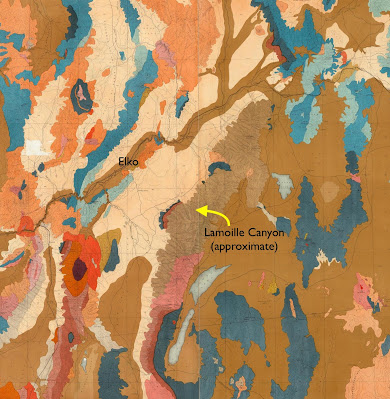
From King's geologic map of the Nevada Plateau. Brown unit that includes Lamoille Canyon is "Archean"—everything older than Cambrian (David Rumsey Map Collection).
Lake Marian; chromolithograph by expedition artist Gilbert Munger (King 1878).

Arnold Hague described the East Humboldt Range as a "bold" ridge 80 miles in length "with many rugged summits reaching over 10,000 feet above sea-level". Unlike most ranges in Nevada, it had been extensively glaciated. "The summits of the East Humboldt Range, from White Cloud Peak to the northern end, all show abundant evidences of glaciation. Very considerable glaciers existed in the elevated group south of Fort Halleck" [location of Lamoille Canyon]. "The erosion of glaciers has excavated deep U-shaped cañons ..."

"Glacier Cañon" by Timothy O'Sullivan, expedition photographer (Hague & Emmons 1877).

Tarn above a U-shaped canyon—textbook glacial features (Hague & Emmons 1877; O'Sullivan photo).

Glacial features almost always trigger memories of a report I wrote long ago for Mr. Brunello's 8th-grade science class. It was titled "Glaciers and Ice Ages". In our little town, the only geologist available for the requisite interview worked in the oil fields. When I arrived at his house, he had a stack of textbooks on the table, and I think I wasn't the only one who was nervous. But that's all I remember. I have no idea whether we discussed U-shaped canyons. In any case, here I am at it again, more than a half century later.

A valley's shape often indicates its creator. V-shaped drainages usually are the work of streams. Flowing water erodes the outsides of bends, and deposits sediment on the insides, making a narrow winding drainage. But a glacier can destroy those bends. Born at high elevations when enough snow and ice have accumulated, it oozes downstream, carrying and shoving rocks and debris—a giant icy rasp grinding away at anything in its path. Slowly it make the valley straighter, the bottom wider, the sides steeper—a U-shaped glacial canyon (more here).

Lamoille Canyon is both V- and U-shaped; shorter U-shaped drainage is the South Fork, a hanging valley (modified from source).
The Lamoille Canyon Road leaves NV Highway 227 near the small community of Lamoille (southeast of Elko). Before reaching the canyon itself, it crosses glacial outwash for several miles. Moraines are visible to the south. Yet once inside the canyon, we see that it is V-shaped, the creek rushing down a narrow bottom.

V-shaped part of Lamoille Canyon. Pullouts are scarce.
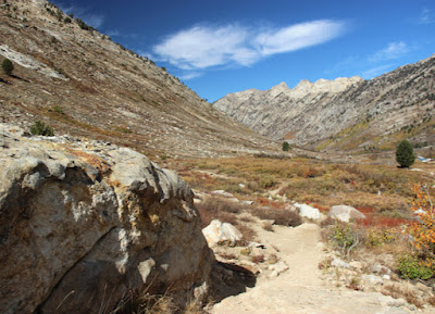
About five miles from the mouth, the canyon starts to change from V to U. The bottom becomes broad, the walls steep—the work of a glacier.
Upper Lamoille Canyon is U-shaped, with nice pullouts for geo-gawking.
Why is Lamoille Canyon both V- and U-shaped? DeCourten and Biggar (2017) suggest that during the most recent glacial advance, 22,000–14,000 years ago, not enough snow and ice accumulated for the glacier to extend below the South Fork. The lower drainage was left in the hands of water, aided by uplift. Because the Ruby Mountains are rising, the stream's gradient is steep, giving it more erosive power.

The road continues upstream below walls of spectacularly-deformed rocks to a popular trail head. However the season was winding down. Though it was a weekend, my field assistant and I had the trail to Lamoille Lake to ourselves.

From the start to the top, the trail provided great views of glacial sculpting.
Pegmatite vein intruded into granite, and polished millions of year later by ice.
The ascent ended about two miles from the trailhead, in a glacial cirque.
Lamoille Lake in its cirque, viewed from about 10,300 ft (source; I didn't get this high!)
Driving back down the canyon, I stopped to ponder contorted rocks in the walls—part of the  "Archean mass" that dominates much of the Ruby and East Humboldt ranges. During the 1868 survey, Clarence King appointed himself to study these ancient rocks. But he wasn't up to the challenge. In fact, he wasn't even aware of it.
What the heck happened here?!

As geologists learned more about the mountains of the American West—and more about geology itself—the Ruby and East Humboldt ranges revealed themselves to be a great puzzle. What's with the mid-crustal metamorphic rocks exposed at the surface, and those greatly displaced fractured sedimentary strata?! Not until the 1980s did someone come up with plausible explanation. It's a complicated story, and still debated. In an upcoming post I will attempt to describe metamorphic core complexes ... while the ghost of Clarence King sighs with relief that he lived in a simpler time.

Geologists back in the day (1864); Clarence King far right (National Portrait Gallery, Smithsonian Institution).

Sources

DeCourten, F, and Biggar, N. 2017. Roadside Geology of Nevada. Mountain Press.

Hague, A, and Emmons, SF. 1877. Descriptive geology. Report of the geological exploration of the fortieth parallel, v. II. GPO.

King, C. 1878. Systematic geology. Report of the geological exploration of the fortieth parallel, v. I. GPO.

Snoke, AW, et al. 1997. Grand tour of the Ruby-East Humboldt metamorphic core complex, northeastern Nevada. U. Dayton, Geology Faculty Publications 39. Available here.