Showing posts with label Nevada geology. Show all posts

Monday, September 18, 2023

A Marine Graveyard in West-central Nevada

Eye of the Ichthyosaur
My visit to the volcanoes of eastern California last May was far too short, but there was nothing I could do. Life called. So after hiking up Panum volcano I raced east past Mono Lake, crossed into Nevada in the Bodie Hills, stopped briefly for gas and groceries in Hawthorne, and raced on. My destination was Berlin in the Shoshone Mountains.

This would be my third attempt. The first was canceled by the covid pandemic. Then the park shut down while pandemic stimulus funds were used for road improvements (still unpaved and washes out occasionally, so check before going). But this year I made it, just in time to set up camp before dark.

Looking west from Berlin across Ione Valley to the Paradise Range beyond, a fine example of the basin-and-range topography that covers much of Nevada.
Berlin is one of Nevada's many abandoned gold-mining towns. It was at its peak at the turn of the century (19th–20th), with a population of about 250 miners and their support staff: blacksmiths, woodcutters, charbonniers, a doctor, a nurse, and a prostitute. Yet by 1911 everyone was gone, a typical boom–bust story. But Berlin didn't disappear entirely. Some buildings remained intact long enough for history buffs to drum up protection.
Berlin Mill in 1910.

Two stamp batteries center bottom, for crushing ore plus water and mercury.
Several decades later Berlin experienced a revival of sorts, thanks to the many curiously-shaped stones in a draw nearby (miners supposedly used them as dinner plates!). In 1928 paleontologist Siemon Mueller of Stanford University examined them, and determined that they were fossilized bones of large marine reptiles—ichthyosaurs. But he left the fossils in place due the remoteness of the site.

In the early 1950s, amateur fossil collector Margaret Wheat visited Berlin and was astonished by what she saw. She convinced Berkeley paleontologist Charles Camp to take a look, thereby launching the excavation of what would become "the world's largest concentration of exposed fossil ichthyosaurs" (Ornduff et al. 2001).
Teeth of the Ichthyosaur
I visited Berlin during the off-season (before Memorial Day), so the Fossil Shelter was closed. Would this be yet another failure? No! This time luck was with me. A ranger cruising the campground offered to open and staff the Shelter. We agreed to meet at 10 am, and he headed off to round up others.
At the Fossil Shelter a small group had gathered in the parking lot, eight in all, a nice size. The Shelter is small and lacks the polish of well-funded visitor centers, as I was happy to discover. I felt far away from the crowds and control that have come to characterize our National Parks. The ranger opened the door, took his position at the front desk, and welcomed us in, providing laminated spiral-bound guides for our tour around a partial excavation of ichthyosaurs. At our own pace, we explored Nevada during Mesozoic time 200+ million years ago. [All quotes below are from the guide or Shelter exhibits.]
Near the front desk, Dr. Camp's reconstruction of Shonisaurus popularis hung overhead, nicely illuminated under the translucent ceiling. However, "There are some notable errors ... [this ichthyosaur] was a much more hydrodynamic predator ... Dr. Camp, however, was only going by the specimens he was excavating and can be forgiven for a few errors when one realizes he had no intact skull, and was working under very primitive and arduous conditions in what was then an extremely remote location."
Shonisaurus popularis by Charles Camp, with owl.
In 1973, Dr. Camp (in black hat below) "had his likeness preserved for posterity" with a bronze tablet installed at the Shelter by the Clampus Vitus, a group dedicated to promoting western history. In fact, Dr. Camp himself was a past Sublime Noble Grand Humbug of the order, hence the hat with C.V. hatband.
Ichthyosaurs are sometimes called sea dragons. One of the earliest collections of a sea dragon fossil was made by a 14-year old nature enthusiast in England—Mary Anning.
I walked slowly around the partially excavated bone bed, which was labeled with letters corresponding to the guide.
"R" marks ribs.
Note the miners' dinner plates (vertebrae).
Origin of this spectacular collection of bones is still debated (DeCourten & Biggar 2017). The skeletons are nearly complete, with bones roughly in proper position (articulated). Were they suddenly stranded by a very low tide? Or maybe this was a birthing area, with occasional deaths; tiny skeletons have found inside several of the larger ones (or were these ichthyosaurs cannibals?). Perhaps they died in deep water under anoxic conditions. The mystery remains.

Before leaving, I chatted once more with the ranger. He explained that visitation was booming (the new road?), and a reservation system for campsites would be available soon. I felt a little sad; probably there are changes ahead for the Fossil Shelter as well. You may want to visit soon.

Sources

DeCourten, F, and Biggar, N. 2017. Roadside Geology of Nevada. Mountain Press.

Orndorff, RL, Wieder, RW, and Filkorn, HF. 2001. Geology Underfoot in Central Nevada. Mountain Press.

Tuesday, May 10, 2022

Return to the Great Paleozoic Sea

Tiktaalik, what were you thinking?! Zina Deretsky, NSF.
In the midst of planning a tour of Paleozoic time in the Great Basin—a way to escape from this confusing disturbing world—I learned that thousands of people share my feelings. Amazing! What made the Paleozoic so alluring? It was a fish, specifically a charismatic fish that ventured onto land 375 million years ago. Tiktaalik (tic-TAH-lick) and its brethren are the progenitors of amphibians, reptiles, birds, and mammals. Yes, it was wandering fish—our ancestor—that got us into this mess!

Urban legend has it that Tiktaalik lived in a late Devonian paradise. The climate was mild. Stream banks, swamps, and other places where water met land were lush with delicious nutritious plants. Life was good. There was no reason to go back to the sea, at least not yet.

But life wasn't perfect. These early tretrapods most likely were stumblers rather than walkers. It probably took them all day to find enough food, and they could not escape predators. But as one paleontologist pointed out, Tiktaalik and its brethren were not burdened with self-awareness. “Everyone is, like, only barely conscious of the idea that they’re alive.” (Ben Otoo, U. Chicago grad student)

Now the Earth is occupied by creatures greatly burdened with self-awareness. Memers rage that Tiktaalik should have stayed in the ocean, thereby saving us all. Maybe those folks should return to the Paleozoic sea themselves. That's what I plan to do.
In the "desert ranges which lie to the west as far as longitude 117° 30' there is no considerable mountain body without its exposure of Palaeozoic strata" (geologist Clarence King, 1878).
Today's Great Basin is rich in remnants of the Paleozoic sea that covered much of today's Nevada and Utah. That sea was born about 700 million years ago, when the supercontinent Rodinea was breaking up. The former west half of Nevada drifted away, leaving the eastern part and adjacent Utah underwater. This was a passive continental margin, on a single tectonic plate. There was no tectonic jostling, only geological serenity (DeCourten 2003). Tens of thousands of feet of sediment accumulated on the sinking ocean floor.

Driving across northern Utah and Nevada, you can't miss the remains of that great sea. Most mountain ranges include or are even dominated by Paleozoic strata. Guidebooks make clear that this is not a monotonous stack of rock. There are nearshore carbonates in the east, and deep water siliceous rocks to the west. Quartzites tell of massive sand floods, beds of dolomite force us to confront the mysterious "dolomite problem", and there are fossils galore.
House Range in western Utah, a monstrous tilted stack of Cambrian rock; view from west, October 2021.
Lone Mountain near Eureka, Nevada, May 2021. Click to view Eureka quartzite (arrow), product of sand floods; other strata include limestone, dolomite, and shale (DeCourten & Biggar 2017).
Steeply-tilted Permian conglomerate at Tyron Gap; sediments were eroded off the now-gone Antler highland. Sulphur Springs Range, Nevada, May 2021.
Limestone and dolomite from late Devonian time, when Tiktaalik was venturing ashore; Devils Gate west of Eureka, Nevada, May, 2021.
Maybe on this trip I will find the perfect outcrop where I can rest peacefully and imagine myself in the warm shallow waters of that great Paleozoic sea, only barely conscious of being alive. This is not a childish pursuit. For all of us, pretending can make the world more magical and meaningful (Scott Hershovitz).

Sources

DeCourten, F. 2003. The Broken Land: adventures in Great Basin geology. U. Utah Press.

DeCourten, F, and Biggar, N. 2017. Roadside Geology of Nevada. Mountain Press.

Imbler, S. 2022 (Apr 29). "Started Out as a Fish. How Did It End Up Like This?" New York Times.

King, C. 1878. Systematic geology. Report of the geological exploration of the fortieth parallel, v. II. GPO.

Monday, February 28, 2022

Ruby Mountains: Island in a Paleozoic sea or metamorphic core complex?

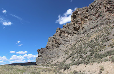
Deformed lower crustal rocks high in the Ruby Mountains. How did this happen?!

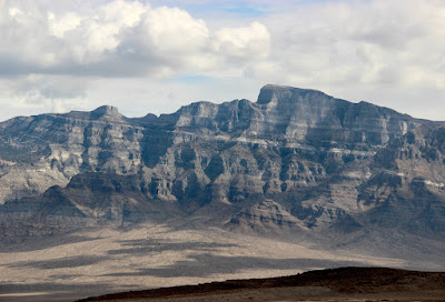
In August of 1868, Clarence King's Survey of the Fortieth Parallel arrived in the East Humboldt Range in northeastern Nevada. The focus was geology. In fact, King was one of three geologists on board, the others being Arnold Hague and SF Emmons. They found the East Humboldts spectacular—"the most prominent uplift lying between the Sierra Nevada of California ... and the Wahsatch of Utah ... with many rugged summits reaching over 10,000 feet above sea-level" (Hague & Emmons 1877).

In the 150 years since, much has changed. The single range is now two: the East Humboldt Range to the north and the Ruby Mountains to the south, separated by today's Secret Pass (formerly Sacred Pass). A pass in the southern Rubies that used to honor explorer John Frémont is now Harrison Pass. It was here that the geologists discovered a dramatic change. To the south were thick beds of sediments deposited in a Paleozoic sea. To the north was a huge mass of seriously deformed rock.

King took it upon himself to study the area north of Frémont's Pass. He assigned the deformed rocks to the Archaean, which at that time included all Earth history before the Cambrian. King concluded these rocks had been an island in a Paleozoic sea. This was a reasonable hypothesis, not at all out of line with current thinking. But that too has changed.

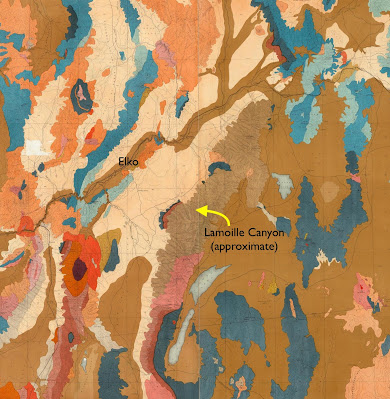
Ruby Mountains and vicinity; points of interest in red (after Snoke et al. 1997).
A year earlier, 25-year-old Clarence King—young, bright, and ambitious—had persuaded Congress to fund a Geological Exploration of the Fortieth Parallel, which he would lead. His assignment was broadly defined—"a geological and topographical exploration of the territory between the Rocky Mountains and the Sierra Nevada ...".

King must have been ecstatic. This was a region poorly known geologically and ripe for discovery. He and his crew spent seven seasons in the field. The result was a large atlas of topographic and geologic maps, and seven reports, published from 1877 to 1880.

Volume II, Descriptive Geology, was the first (Hague & Emmons 1877). Arnold Hague wrote the section about the East Humboldt Range. He began with the area south of Frémont's (Harrison) Pass, in today's southern Ruby Mountains. Here were very thick beds of Paleozoic rocks, with limestone conformably overlying quartzite. "The quartzites appear a little calcareous and the limestones somewhat siliceous, but the transition is made by a rapid passage from one to the other."

North of Frémont's Pass "a change takes place in the rock ...", noted Hague laconically. In fact it was a dramatic change. The thick beds of Paleozoic sediments were replaced with deformed metamorphic rocks. Relying on King's notes, Hague described Archaean quartzites and crystalline schists extending from the crest all the way down to the valley to the west, where they disappeared under Pliocene sedimentary rocks. This situation continued to the northern end of the range. Aside from one or two small remnants, the Paleozoic limestone was gone.

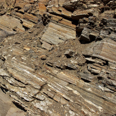
Archaean quartzite, [East] Humboldt Range, Nevada (King 1878).
The next report published was Volume I, Systematic Geology (King 1878), an ambitious tome. Much of it was what we call historical geology—a challenging subject then. Some very basic geology had yet to be figured out, for example the composition of the Earth, and the origin of mountains.

Contractionists argued the Earth was a solid body that was cooling and contracting. Wrinkling of the shrinking surface created mountains. Others argued that the Earth's interior was molten; convection currents in the molten interior created volcanoes and other mountains. Clarence King leaned toward the latter hypothesis, but addressed it only briefly in his report. "I prefer to build no farther till the underlying physics are worked out ... leaving their minute discussion to a day in the near future when it can be done on a firmer physical foundation" (italics mine).

What was King thinking when he wrote "near future"? Years? Decades? In fact, it would be almost a century before geologists came up with plate tectonics, and another twenty years passed before "metamorphic core complex" was added to their vocabulary.

East Humboldt Range (Hague & Emmons 1877). Click to view geologist on an Archean "island".

King took it upon himself to discuss "the configuration and general relief of the area of the Fortieth Parallel at the close of Archaean time". It was here that he revealed his thinking about the creation of today's mountains. "Over the whole distance from the Rocky Mountains to western Nevada, in almost every prominent range, the contact may be observed between the Archaean and the Palaeozoic series. At times, Archaean summits are seen to rise above the level of the deposition of the Upper Carboniferous ..." King concluded the ancient rocks at the crests of today's mountain ranges were once part of Archaean ranges. Then the high peaks became islands in a Paleozoic sea.

The East Humboldt Range was a fine example: "The Humboldt was one of the greater Archaean ranges, and the subsequent Palaeozoic rocks are deposited unconformably, abutting against its steeply inclined flanks, leaving unsubmerged insular Archaean summits."

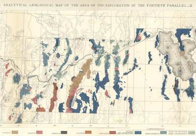
In the Archaean section of Systematic Geology, King included a map of Archaean rocks with a cross section. The excerpt below shows "Archaean bottom of the ocean in which Paleozoic sediments were deposited ...". Note that the high peaks of the East Humboldt Range were above sea level during deposition of the Wahsatch limestone.

 From King 1878, click to view. 
Today the Ruby Mountains/East Humboldt Range is considered a metamorphic core complex (MCC; also called core complex). MCCs are giant complicated structures, and it wasn't until the early 1980s that someone came up with a generally acceptable hypothesis.

Based on Peterson & Buddington 2014, DeCourten & Biggar 2017.
As shown above, MCCs include a dome of lower crustal metamorphic rock exposed to some extent at the surface. Above it are unmetamorphosed sedimentary rocks of the upper crust. These have been faulted, fractured, detached, and transported away from the crest of the dome. In other words, today's geologists think metamorphic rocks in the Rubies and East Humboldts came not from Archaean high peaks but from deep below the surface. This is very cool! It's not often we get to look at rocks metamorphosed by the great pressures and high temperatures of the lower crust.

The highly deformed metamorphic rocks and the undeformed sedimentary rocks are separated by a low-angle detachment fault. At the contact, the metamorphic rocks have been mylonized—highly deformed by very large shear strain. I would think giant moving chunks of rock could do just that, especially if the lower crustal rocks were a bit ductile from all the heat down there.

Mylonized (seriously scrunched) rock, East Humboldt Range. NV Highway 229 west of Secret Pass.

I first learned about MCCs on trip across the Great Basin about 15 years ago. In Broken Land (2003), Frank DeCourten described how it had taken him several decades to get up the nerve to visit one. "The complexity of these structures struck me as virtually incomprehensible." I felt the same way, but fortunately I had several guidebooks along on my trip last October.

MCCs are intimidating in part because they are so huge, too big to see. We can only glimpse bits of the various parts here and there. The best view of a MCC on my trip was not in the Rubies but the northern Snake Range. In the photo below, the very thin rock band is mylonite, marking the low angle detachment fault. Outcrops above it are fractured Paleozoic sedimentary rocks that moved eastward.

Snake Range north of US Highway 50 near turnoff to Baker, NV.
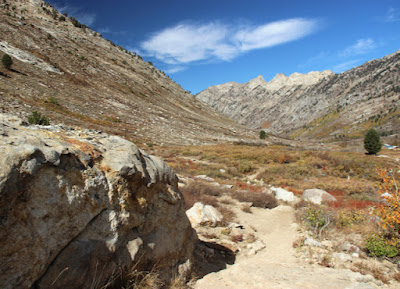
On the west side of the Ruby Mountains, the walls of Lamoille Canyon provide views of contorted metamorphic rocks of the lower crust, which domed up with formation of the MCC.

A glimpse of the interior of the Earth!
The upper canyon features a pegmatite dike–sill complex intruded into gneiss and marble.
Pegmatite in gneiss along trail to Lamoille Lake.
King thought the metamorphic rocks high in the East Humboldt Range were Archaean, equivalent to Precambrian today. He wrote, "... we have no conclusive proof of metamorphism of Palaeozoic strata to so extreme a point as to endanger a mistake between the resultant rocks and those of Archaean age." But King lived before the time of radiometric dating. Turns out most of the metamorphic rocks high in the Rubies and East Humboldts are indeed Paleozoic; only a few are older (Proterozoic).

In road cuts along Highway 229 in Secret Canyon, geogeeks can experience mylonite up close. In the photos below, the rocks midslope are Mississippian and Pennsylvanian sedimentary formations "dismembered" by serious deformation.

I collected several distinctive mementos to add to my collection at home.
Now the really hard question: What created the Ruby/East Humboldt MCC? Maybe it was extension, stretching and thinning of the crust. This is a reasonable hypothesis given that North America from central Utah to eastern California has been expanding for c. 30 million years—enough to double the distance between Reno and Salt Lake City (DeCourten & Biggar 2017). But regional extension isn't enough. Extension in the Ruby/East Humboldt MCC is extreme. Faulted and fractured Paleozoic sedimentary rocks moved as much 50 km in places. Also, MCC formation started well before regional extension.

There are other questions. How were huge chunks of rock set in motion and transported so far if the detachment fault is low angle? And why did all this happen? Did extreme extension allow the rise of lower crustal rocks, formerly buried 20 km deep or more (i.e., isostasy in response to thinning)? Or did anomalous mantle convection cause upwarp of deformed crustal rocks? MCCs seem so strange—are they real?

Maybe today's metamorphic core complexes will turn out to be historical curiosities, like Clarence King's island theory of 150 years ago. King acknowledged his hypothesis was largely speculative. But he wasn't much troubled, being satisfied to contribute "whatever value this Report may possess, either as a permanent contribution to knowledge or as a stepping-stone worthy to be built into the great stairway of science ..."
How high have we climbed on the great stairway of science?

Sources

Bartlett, RA. 1962. Great surveys of the American West. U. Oklahoma Press.

DeCourten, F, and Biggar, N. 2017. Roadside Geology of Nevada. Mountain Press.

Hague, A, and Emmons, SF. 1877. Descriptive geology. Report of the geological exploration of the fortieth parallel, v. I. GPO.

King, C. 1878. Systematic geology. Report of the geological exploration of the fortieth parallel, v. II. GPO.

Maley, TS. 2017. Metamorphic core complexes and related features, in Idaho Geology, 2nd ed. PDF.

Peterson, J., and Buddington, A. 2014. A geological study of the McKenzie Conservation Area, Spokane County, Washington. Conference Paper.

Snoke, AW, et al. 1997. The Grand Tour of the Ruby-East Humboldt Metamorphic Core Complex, Northeastern Nevada: Part 1-Introduction & Road Log. Geology Faculty Publications. 39.

Monday, January 17, 2022

Lamoille Canyon—V, U, and much more

A "glacier cañon" in the Ruby Mountains (2021, but in the style of 1868).

Lamoille Canyon, in the Ruby Mountains of northeast Nevada, is a geotripper's dream. Attractions range from Pleistocene sculptures to seriously-deformed mid-crustal Proterozoic rocks, all visible from the paved road up the canyon. And there are guidebooks! That wasn't always the case, of course. The first geotrippers had to decipher the geology themselves. They got some things right, but for others, they were wide of the mark.

In 1868, geologists Clarence King, Arnold Hague, and SF Emmons were traversing Nevada from west to east, during the second season of King's Geological Exploration of the Fortieth Parallel. In August they reached the East Humboldt Range, which at that time included the Rubies. The men were impressed. They found it to be "the most prominent uplift lying between the Sierra Nevada of California ... and the Wahsatch of Utah" (Hague & Emmons 1877).

King's seven-year survey would result in five geologic maps and an epic report—eight volumes in all and nicely illustrated, with photographs even!

From King's geologic map of the Nevada Plateau. Brown unit that includes Lamoille Canyon is "Archean"—everything older than Cambrian (David Rumsey Map Collection).
Lake Marian; chromolithograph by expedition artist Gilbert Munger (King 1878).

Arnold Hague described the East Humboldt Range as a "bold" ridge 80 miles in length "with many rugged summits reaching over 10,000 feet above sea-level". Unlike most ranges in Nevada, it had been extensively glaciated. "The summits of the East Humboldt Range, from White Cloud Peak to the northern end, all show abundant evidences of glaciation. Very considerable glaciers existed in the elevated group south of Fort Halleck" [location of Lamoille Canyon]. "The erosion of glaciers has excavated deep U-shaped cañons ..."

"Glacier Cañon" by Timothy O'Sullivan, expedition photographer (Hague & Emmons 1877).

Tarn above a U-shaped canyon—textbook glacial features (Hague & Emmons 1877; O'Sullivan photo).

Glacial features almost always trigger memories of a report I wrote long ago for Mr. Brunello's 8th-grade science class. It was titled "Glaciers and Ice Ages". In our little town, the only geologist available for the requisite interview worked in the oil fields. When I arrived at his house, he had a stack of textbooks on the table, and I think I wasn't the only one who was nervous. But that's all I remember. I have no idea whether we discussed U-shaped canyons. In any case, here I am at it again, more than a half century later.

A valley's shape often indicates its creator. V-shaped drainages usually are the work of streams. Flowing water erodes the outsides of bends, and deposits sediment on the insides, making a narrow winding drainage. But a glacier can destroy those bends. Born at high elevations when enough snow and ice have accumulated, it oozes downstream, carrying and shoving rocks and debris—a giant icy rasp grinding away at anything in its path. Slowly it make the valley straighter, the bottom wider, the sides steeper—a U-shaped glacial canyon (more here).

Lamoille Canyon is both V- and U-shaped; shorter U-shaped drainage is the South Fork, a hanging valley (modified from source).
The Lamoille Canyon Road leaves NV Highway 227 near the small community of Lamoille (southeast of Elko). Before reaching the canyon itself, it crosses glacial outwash for several miles. Moraines are visible to the south. Yet once inside the canyon, we see that it is V-shaped, the creek rushing down a narrow bottom.

V-shaped part of Lamoille Canyon. Pullouts are scarce.
About five miles from the mouth, the canyon starts to change from V to U. The bottom becomes broad, the walls steep—the work of a glacier.
Upper Lamoille Canyon is U-shaped, with nice pullouts for geo-gawking.
Why is Lamoille Canyon both V- and U-shaped? DeCourten and Biggar (2017) suggest that during the most recent glacial advance, 22,000–14,000 years ago, not enough snow and ice accumulated for the glacier to extend below the South Fork. The lower drainage was left in the hands of water, aided by uplift. Because the Ruby Mountains are rising, the stream's gradient is steep, giving it more erosive power.

The road continues upstream below walls of spectacularly-deformed rocks to a popular trail head. However the season was winding down. Though it was a weekend, my field assistant and I had the trail to Lamoille Lake to ourselves.

From the start to the top, the trail provided great views of glacial sculpting.
Pegmatite vein intruded into granite, and polished millions of year later by ice.
The ascent ended about two miles from the trailhead, in a glacial cirque.
Lamoille Lake in its cirque, viewed from about 10,300 ft (source; I didn't get this high!)
Driving back down the canyon, I stopped to ponder contorted rocks in the walls—part of the  "Archean mass" that dominates much of the Ruby and East Humboldt ranges. During the 1868 survey, Clarence King appointed himself to study these ancient rocks. But he wasn't up to the challenge. In fact, he wasn't even aware of it.
What the heck happened here?!

As geologists learned more about the mountains of the American West—and more about geology itself—the Ruby and East Humboldt ranges revealed themselves to be a great puzzle. What's with the mid-crustal metamorphic rocks exposed at the surface, and those greatly displaced fractured sedimentary strata?! Not until the 1980s did someone come up with plausible explanation. It's a complicated story, and still debated. In an upcoming post I will attempt to describe metamorphic core complexes ... while the ghost of Clarence King sighs with relief that he lived in a simpler time.

Geologists back in the day (1864); Clarence King far right (National Portrait Gallery, Smithsonian Institution).

Sources

DeCourten, F, and Biggar, N. 2017. Roadside Geology of Nevada. Mountain Press.

Hague, A, and Emmons, SF. 1877. Descriptive geology. Report of the geological exploration of the fortieth parallel, v. II. GPO.

King, C. 1878. Systematic geology. Report of the geological exploration of the fortieth parallel, v. I. GPO.

Snoke, AW, et al. 1997. Grand tour of the Ruby-East Humboldt metamorphic core complex, northeastern Nevada. U. Dayton, Geology Faculty Publications 39. Available here.