Showing posts with label Wyoming history. Show all posts

Thursday, August 26, 2021

The Snowy Range, 2 billion years in the making

Medicine Bow Mountains and the Snowy Range rise above the Laramie Plains.
In the early 1980s, author John McPhee was gathering information for a book, Rising from the Plains, about Wyoming geology. He crossed the state on Interstate 80 from east to west, in the company of one of the grand old men of Wyoming geology, the late John David Love. McPhee took notes while Love drove and expounded on the landscape.

Near Laramie, as they looked west at distant mountains, McPhee was struck by the illusion: "... the Medicine Bow Mountains and the Snowy Range stood high, sharp, and clear, each so unlike the other that they gave the impression of actually being two ranges ... the flat-crested Medicine Bows, dark with balsam [subalpine fir], spruce, and pine; and, in the far high background, the white and treeless Snowy Range."

In fact, the latter sits atop the former, and geologically they are one.

Ancient sediments

In 1868, just a few months after Laramie was established, Arnold Hague of Clarence King's Fortieth Parallel Survey became the first geologist to explore the Medicine Bows. In his 1877 report, Hague described a flat-crested mountain range with "elevated plateau country, nearly 10,000 feet above sea-level ... dotted over with numerous alpine lakes." From this high surface rose a sharp-edged ridge that "culminates in Medicine Peak, a grand, broad central mass." [The plateau country is now Libby Flats, the ridge the Snowy Range, and the high point Medicine Bow Peak.]

The Snowy Range on the horizon, above Libby Flats.

"... the amphitheatres, with mural faces 1,500 feet deep, cut out of pure white quartzite, are very striking," wrote Hague. The peak itself "is a mass of pure white quartzite, rising nearly 2,000 feet above the surrounding country ..." He assigned the quartzite to what was then called the "Archean series"—the oldest rocks on Earth, specific age unknown. At that time, it was the best a geologist could do.

Hague found layers of pebbles and other signs of bedding in the quartzite, convincing him it had started as deposited sediments. He also concluded that the beds, originally horizontal, had been steeply tilted. But if he had further thoughts about how the quartzite and ridge formed, he didn't share them.
Pebbles in quartzite, cited by Hague as evidence of sedimentary origins.

Two decades later, a geology graduate student from the University of Wisconsin, Charles Van Hise, crossed the Medicine Bow Mountains on horseback in just three days. During his brief visit, he examined the rocks at the crest, taking notes for his PhD dissertation about North America's Precambrian rocks (equivalent to "Archean series" used by Hague). Like Hague, he described the quartzite as ancient and sedimentary.

Neglected no longer

In 1917, a third geologist came to southeast Wyoming to study the Medicine Bow Mountains. "Dr. Eliot Blackwelder, head of the department of geology at the University of Illinois arrived in this city this morning ..." reported the Laramie Boomerang on July 24. He would "start on a geological expedition in the Medicine Bow mountains in a few days." Blackwelder was interested specifically in the ancient rocks at the crest.

Blackwelder found the Medicine Bows a wonderful place to work, as he explained in his report. "In spite of its ready accessibility, this interesting range has been strangely neglected by geologists until the last decade. ... no detailed work seems to have been attempted." He would fill that gap, spending six weeks in the range in 1917, and a month in 1925.

At the end of 1926, Blackwelder published his Precambrian geology of the Medicine Bow Mountains. He named the "great, massive quartzite" of the Snowy Range the Medicine Peak quartzite, describing it as "extraordinarily thick"—on the order of 5600 ft! He too concluded it consisted of metamorphosed sediments dating from Precambrian time (but still without a specific age). Unlike his predecessors, however, Blackwelder offered a probable scenario for its origins.
Cross-section through the Medicine Bow Mountains in the area of the Snowy Range. Note the thickness of the Medicine Peak quartzite! (labeled "D"). Blackwelder 1926.
 Medicine Peak quartzite above Mirror Lake. Added arrow points to a huge dike—magma injected into the quartzite. Blackwelder 1926.

Reading the rocks

The Medicine Peak quartzite started as quartz sand, became sandstone, and then was metamorphosed under intense pressure to its final form—very hard rock that sparkles in the sun. Yet it still provides clues about its ancient birth. Blackwelder often spotted ripple marks and cross-bedding (layers at angles), evidence that the sand had accumulated in shallow active water. He suggested it was deposited just offshore, where it would be shaped by waves, or streams flowing into the sea.
Cross-bedding preserved in Medicine Peak quartzite; block is about 1 m long.
And yet the quartzite was so thick—at least 5600 ft even after compaction and metamorphism! How could so much sand accumulate in shallow water? Blackwelder turned to a modern-day analogy. "The great thickness of pure quartzite represents sifted sand that might have been deposited and worked over on a marine shelf, like that around Cape Hatteras, on the Atlantic coast of the United States."

But if so, how did sand on a marine shelf become quartzite 11,000 ft above sea level, far from any ocean? In Blackwelder's day, there was no good answer for this kind of question. It would be almost 40 years before enlightenment arrived.

Earth's dancing plates

By the early 1960s, geologists had accumulated enough evidence to put forward the theory of plate tectonics, now widely accepted. The Earth's rigid outer shell, the lithosphere (crust and upper mantle), consists of giant "tectonic plates" that grow, break, stretch, compress, dive under, thrust over, and collide in a slow but powerful dance. In the process, landscapes are changed on a grand scale.
Earth's plates (source)—very different from 2 billion years ago.
It was the movement of tectonic plates that created the Snowy Range. Here's the basic plot: Along the Wyoming coast, a massive amount of sand accumulated offshore. A plate collision pushed up mountains, metamorphosing and tilting the sand(stone). These mountains were worn down, their remnants buried. Then another tectonic confrontation pushed up the Medicine Bow Mountains. Erosion exposed the ancient quartzite and shaped the Snowy Range.

The former world

The Medicine Peak quartzite started as sand 2.1 billion years ago. Back then, Wyoming was part of Superia, a smallish supercontinent. But Superia was coming apart, leaving Wyoming on the coast of a growing ocean. Sand and other sediments would accumulate just offshore for some 200+ million years.
Modified from Mitchell and others, 2021.
Then something changed, something huge! Exactly what may be lost to deep history, or maybe not yet discovered. In any case, the widening ocean disappeared.

Collision and a continental suture

In their studies of the quartzite, Hague, Van Hise, and Blackwelder all could see that the beds of sand, which were horizontal when deposited, were now far from it. "In general the sedimentary beds are nearly vertical or steeply inclined to the southeast," wrote Blackwelder. They had been tilted almost 90 degrees!

The cause was continental collision. About 1.78 billion years ago, a smallish tectonic plate called the Green Mountain Terrane bumped up against the Wyoming coast. This "collision" went on for 40 million years, producing among other things a continental suture called the Cheyenne Belt—a zone of highly deformed rocks.
Inferred location of the Cheyenne Belt, a continental suture (original source unknown).
Deformed rock of the Cheyenne Belt, Medicine Bow Mountains (field trip stop 1); ruler is 15 cm.
As is typical for such a collision, a mountain range was pushed up, tilting the sand-turned-to-quartzite on its side. But that mountain range is now mostly gone. Though they may seem permanent to us, mountains too have lifetimes. As soon as they rise, erosion goes to work wearing them down, sometimes burying them in their own debris.

The remnants of the ancient range would lie buried for hundreds of millions of years, while sediments accumulated to great thickness. The quartzite would be covered by tens of thousands of feet of limestone, sandstone, and shale by the time the next big change arrived.

West Coast happenings impact Wyoming

That change was uplift of the Medicine Bow Mountains. It happened during a great mountain building event called the Laramide Orogeny, which started 80 million years ago, lasted almost 40 million years, and created mountain ranges from Mexico to Canada—the Rockies. In contrast with the previous collision, the plate jostling this time was remote. Almost a thousand miles to the west, the oceanic Farallon plate was diving under the North American plate, compressing the continent and pushing up mountains far inland.
Rocky Mountains due to subduction far to the west (source). 
Of course, as soon as the Medicine Bow Mountains rose, erosion set in. Eventually enough of the sedimentary rock cover was removed to expose the ancient Precambrian core. Being super hard and durable, the Medicine Peak quartzite eroded much more slowly, and was left as a high-standing ridge.

As Eliot Blackwelder would write 40 or 50 million years later, "The Snowy Range owes its prominence and position to a great, massive quartzite formation."

Field trip—you too can read the rocks!
The Snowy Range at the crest of the Medicine Bow Mountains, just 50 miles west of Laramie.
This tour includes five stops—four at the crest and one en route. Start early to include a hike to the summit of Medicine Bow Peak.

Zero your odometer at the junction of Highways 130 and 230 in West Laramie, and drive west on 130. At about 19.5 miles, as you descend into the Centennial Valley, slow down to take in the view. Immediately ahead are the forested Medicine Bow Mountains. Seemingly behind and above is the Snowy Range. Even this close, the illusion persists.

1. At 36 miles, turn right and park along the Brooklyn Lake Road near Nash Fork Campground. To view a bit of the 1.78 billion year old continental suture, walk into the campground, stay left on the loop, and just past the fee station and site 27, walk left (west) 20 or 30 yards to dark rock above the highway. Look around your feet for fine laminations, with waves and tight chevrons created by continental collision. Then check the two huge white quartzite boulders (dropped here by glaciers) for cross-bedding from deposition offshore, and gray bands with white pebbles flattened during collision.

2. At 40 miles, visit Libby Flats observation point (with restrooms and a "castle"). Enjoy Arnold Hague's "elevated plateau country ... dotted over with numerous alpine lakes."

3. A quarter mile farther west on Hwy 130, turn left to Medicine Bow Peak Over Look, with helpful interpretive signs. On the Snowy Range diagram, find The Diamond with Mirror Lake below—location of Blackwelder's photo included here, and the next stop.

4. Continue west 1.3 mile to Mirror Lake Picnic Area. Near the entrance, compare your view with Blackwelder's photo. In looking at the spectacular face, remember ... it is beds of sand turned vertical! From the high point of the loop, examine the large dark dike (marked in photo)—magma injected into the quartzite while it was still underground.

5. Continue west a short distance to the first of two Lake Marie parking lots. At the east end, explore the field of white quartzite boulders. Bedding and cross-bedding are common. Search to find gray bands with flattened white pebbles, evidence of plate tectonics in action!

A short distance farther on the highway is the west Lake Marie parking lot and a trailhead for Medicine Bow Peak, 12,013 ft elevation. The round trip is 8 or 9 miles. A shorter trail leaves from Lewis Lake, but doesn't have as much wonderful scenery in my opinion. A loop can be done to include both (see maps online).
Cross-bedded quartzite en route to Medicine Bow Peak from west Lake Marie trailhead.
Summit of Medicine Bow Peak—a giant pile of quartzite boulders.

Sources

Blackwelder, E. 1926. Precambrian geology of the Medicine Bow Mountains. Bull. Geol. Soc. Am. 37:615–658.

Hague, A. 1877. Medicine Bow Range, in US Geological Exploration of the 40th Parallel, vol. ii: 94–111. Washington, DC: GPO.

Hausel, WD. 1993. Guide to the geology, mining districts, and ghost towns of the Medicine Bow Mountains and Snowy Range Scenic Byway. WSGS Public Information Circular 32. Free PDF.

Sullivan, WA, and Beane, RJ. 2013. A new view of an old suture zone: evidence for sinistral transpression in the Cheyenne belt. GSA Bull. 125:1319–1337.


This post is based on my recent contribution to the History column of the Laramie Boomerang, which features articles by volunteers eager to share our local history. We also hope to relieve the dismal monotony of pandemic news, and support our flagging local newspaper! Articles are archived at the Albany County Historical Society website.


Tuesday, August 17, 2021

Frank Tweedy's Traveling Plants: WY to NYC & back

Frank Tweedy. Union College Special Collections (used with permission); date unknown.
Readers of this blog may remember Frank Tweedy of the US Geological Survey, who surveyed the Laramie Plains in 1892 (Mapping the Laramie Plains, 3rd dimension captured). In August of that year, the Laramie Boomerang announced that Tweedy and assistant James McFarland would "commence work upon the topography of this section of the country." Three years later, the "Laramie Sheet" was published—one of the first topographic maps for Wyoming.

In January of 1903, there again was a Frank Tweedy in the Laramie news. "Prof. Nelson [University of Wyoming] has received a rare collection of plants from Mr. Frank Tweedy ... a botanist of considerable distinction" reported the Republican. Were USGS surveyor Frank Tweedy and distinguished botanist Frank Tweedy one and the same? And how did 700 plants survive a trip to Laramie in January?!

Dead, flat, & dry

Actually, survival was not an issue, for these plants were already dead. But they still were of great value. All were collected in 1900 in the wilds of the northern Bighorn Mountains. There they were carefully arranged in paper folders so that parts needed for identification were visible, and placed in a plant press with absorbent felt sheets until dry (several days to several weeks, depending on weather).

After the field season, they made their way east, ending up at the New York Botanical Garden where the great botanist, Per Axel Rydberg, either identified them, or, if they were new to science, named them himself. Then in 1903, "upward of 700" traveled west to Laramie, each accompanied by a label with the plant's name, collection location, date, and collector—Frank Tweedy.

At the university there was more processing, for dried plants are fragile, and won't last long if left loose in paper folders. They were mounted on 11" x 18" sheets of durable paper, preserving them for centuries to come, and properly filed in the university herbarium.

Pleated gentian, Gentiana affinis, collected by Frank Tweedy in 1900. Rocky Mountain Herbarium.

Herbarium?

If you don't know what a herbarium is, you're not alone. Few people do. Many think it's some kind of greenhouse, but actually it's the opposite—a collection of pressed dried plants. The first, called a "hortus siccus" (dry garden), was created in the 1520s by Italian botany professor Luca Ghini. He wanted a way to teach plant identification in the winter, so he pressed and dried plants, and glued them to paper sheets. Fed up with their ancient textbooks, Ghini's students loved him for it.

Today, students still use herbarium specimens to learn to identify plants. But they took on a much bigger role during the golden era of global exploration (16th–19th centuries)—documentation of the world's flora. Herbaria proliferated and flourished. Now there are at least 3300, holding nearly 400 million pressed dried plants!

New herbarium grows fast

By 1892, the University of Wyoming had been operating for five years with a botany professor (Aven Nelson) but no herbarium! This was unacceptable for the state's only university. Fortunately, Experimental Station Supervisor Burt C. Buffum had collected Wyoming plants for several years, accumulating on the order of 500. Several hundred were set aside for an exhibit at the 1893 World's Columbian Exposition in Chicago. As for the rest, University President Albinus Johnson directed Nelson to use them to start a herbarium.

Nelson knew little about plant identification and herbarium management, but that didn't slow him down. In 1899, he launched an ambitious project. For 14 weeks, he traveled Yellowstone Park by horse-drawn wagon, with his wife, two daughters, and two students. They collected zealously, returning to Laramie with 30,000 specimens! Most were duplicates, to be sold or traded to fund and expand the UW herbarium.

Collecting plants in Yellowstone, 1899. Photo by Aven Nelson; American Heritage Center (AHC).
Before the trip, Nelson wrote to his esteemed colleague Per Axel Rydberg at the NY Botanical Garden, asking where in Yellowstone he should collect. Rydberg replied: "The flora of the park is, however, well worked up as several collectors have been in there ... The one that has done the most, however, is Frank Tweedy of US Geological Survey. He spent two whole summers in the park."

Indeed, surveyor Frank Tweedy and botanist Frank Tweedy were one and the same!

An eye for novelty

Frank Tweedy was born, raised, and educated in New York, graduating from Union College in 1875 with a degree in civil engineering. He began his surveying career the next year in the Adirondacks, followed by a stint as a sanitation engineer in Rhode Island. All the while, he collected plants.

If we follow Tweedy's trail of herbarium specimens (accessible online), we go from New York to New Jersey to Rhode Island. But then we make a huge leap west. In 1882, Tweedy went to work as a topographer on the Northern Transcontinental Survey in Washington Territory. And he collected plants.

For Tweedy, this was a very different kind of botanical world, largely unexplored and rich in novelties—species new to science. He collected his first that summer, a grass from the Wenatchee Mountains. It was named Tweedy's reedgrass (Calamagrostis tweedyi) by grass expert FL Scribner, who wrote: "Mr. Tweedy has been a careful and zealous collector of the plants of the various sections of our country which he has visited, and it is with pleasure that I dedicate this species to him."
Calamagrostis tweedyi, Tweedy's reedgrass, from American Grasses (FL Scribner 1897).
This was the first of more than 100 plant species discovered by Tweedy, and the first of at least 35 named in his honor. By the time his specimens arrived in Laramie in 1903, he was a highly-regarded pioneering botanist of the American West.
Erigeron tweedyi, Tweedy's fleabane. Photo by Matt Lavin (Flickr).

Herbarium in the news

Meanwhile the UW herbarium had grown rapidly, thanks to collecting by Nelson and his students, and acquisitions through purchase and trade. In 1899, he convinced the University Trustees to make it a separate institution—the Rocky Mountain Herbarium (as it is today), with Nelson as curator.

Within a few years, Nelson and the Rocky Mountain Herbarium had become newsworthy. In May of 1902, the Rawlins Republican reported "[a set] of 800 Wyoming plants has just been forwarded to the Carnegie museum (Pittsburg) by Professor Nelson" who also "received an interesting collection of plants, some 300 in number, from Dr. Riser of Rawlins ...". Even more notable, Nelson shipped a collection of potentillas (cinquefoils) to Germany, to "Dr. Theodore Wolf, a German botanist, who is preparing a monograph of all the species of the genus in the world." In exchange, German potentilla specimens would be sent to the Rocky Mountain Herbarium.

In July, the Cheyenne Daily Leader had exciting news. "12,000 Specimens of Rare Herbs and Plants for the State University" had been collected in Nevada, New Mexico, Utah, and Wyoming by Leslie Goodding, one of Nelson's students. About 800 species were represented, including every botanist's dream—species new to science (several were named in Goodding's honor).
University of Wyoming, 1901. AHC, SH Knight Collection.
According to the Laramie Boomerang, by September of 1902, UW's herbarium contained 36,000 specimens—impressive given there were still just three buildings on campus (not counting barns and greenhouses). At the end of the year, when Nelson's articles about saltbushes and hawthorns were published in the University of Chicago's Botanical Gazette, the Laramie Republican proudly and rightly declared, "Prof. Nelson is a recognized authority on Rocky Mountain and western plants."

Thus we shouldn't be surprised that a botanist of Tweedy's caliber would contribute a "rare collection of plants" to the Rocky Mountain Herbarium.

Imagining the past

During my research, I often imagined Tweedy and Nelson in conversation—the renowned western botanist encouraging Nelson's ambitions. Did they meet when Tweedy was surveying the Laramie Plains in 1892? Or maybe they made arrangements in May of 1901, when the Personals section of the Boomerang reported that "Frank Tweedy of Washington is in the city" (no further details).

I searched and searched for correspondence between the two men, eager to find a climax for this story. Instead, I discovered that the Republican, or perhaps Nelson, had led me astray.

In examining Tweedy's specimens at the Rocky Mountain Herbarium, I discovered a puzzling label on the lower left corner of each: "Received from A.A. Heller, 1903". As I would learn, Nelson didn't receive the specimens directly from Tweedy. He bought them from Amos Arthur Heller. (Heller probably got them through a trade, but we can't be sure.)

A fantastic bargain just the same

Heller was an American botanist active from 1892 to 1940. The standard botanical sources include his professorships in Minnesota, California, and Nevada, as well as work for prominent botanical institutions. But I knew nothing of his stint as a freelance plant dealer until I visited UW's American Heritage Center, where I found a folder of letters from Heller to Nelson. 

On December 3, 1902, Heller wrote Nelson from Puerto Rico: "If you care for them, I have a collection of 700 Wyoming plants collected by Frank Tweedy, which I will sell for $45.00. There are a lot of new species among them [named] by Rydberg, and I understand he [identified] the whole collection. I am giving you the first chance at these, as I know they will be of more value to you than any one else." He then advised, "If you want the Wyoming plants, Mrs. Heller [in Pennsylvania] will attend to sending them."

Apparently Nelson jumped at the opportunity. In a letter dated December 29, E. Gertrude Heller wrote: "I will ship you the plants at once ...", which she must have done since they arrived sometime before January 14, when their story appeared in the Laramie news.

Surely Nelson was happy with his purchase—nearly 700 specimens representing 500+ species, collected by a highly-respected botanist. And, as the Republican explained, "As not more than three of these sets of plants are in existence this herbarium is fortunate in securing one" (the others went to the National Herbarium and the NY Botanical Garden).

Furthermore, "since [Tweedy's] work carries him into many places, inaccessible to the ordinary collector, his plants are unusual and interesting." Here the Republican was correct. A dozen of the specimens were species new to science! Obviously Frank Tweedy was very good at spotting botanical novelties, even while surveying.
Tweedy's gilia (Gilia tweedyi), collected by Frank Tweedy in the Bighorn Mountains. Dried plant is about 8 in tall. H. Marriott photo; added flower photo by Matt Lavin, 2012 (Flickr).

🌺🌼🌾

This post is based a recent contribution to the History column of the Laramie Boomerang, which features articles by volunteers eager to share our local history. We also hope to relieve the dismal monotony of pandemic news, and support our flagging local newspaper! Articles are archived at the Albany County Historical Society website.

For more about Frank Tweedy, perhaps our most under-appreciated pioneering botanist, see his Wikipedia page. It was created just last year by this author (herself a botanist), and Noel Sherry, who is exploring Tweedy's mapping, plant collecting, and more.

Friday, April 9, 2021

Mapping the Laramie Plains II: 3rd dimension captured

Two views of Sheep Mountain[s]: 1895 USGS map and 2011 photo looking northwest from Sodergreen Lake.

To refresh your memory, and for you who missed Mapping the Laramie Plains I: in pursuit of the 3rd dimension, this story began with the promise of a map of the Laramie area on which "almost every hill and cañon [sic] can be determined at a glance!" according to the Laramie Boomerang in 1893. Yet the post ended before we could share in the reporter's excitement. That's because the back story was so long—three millennia.

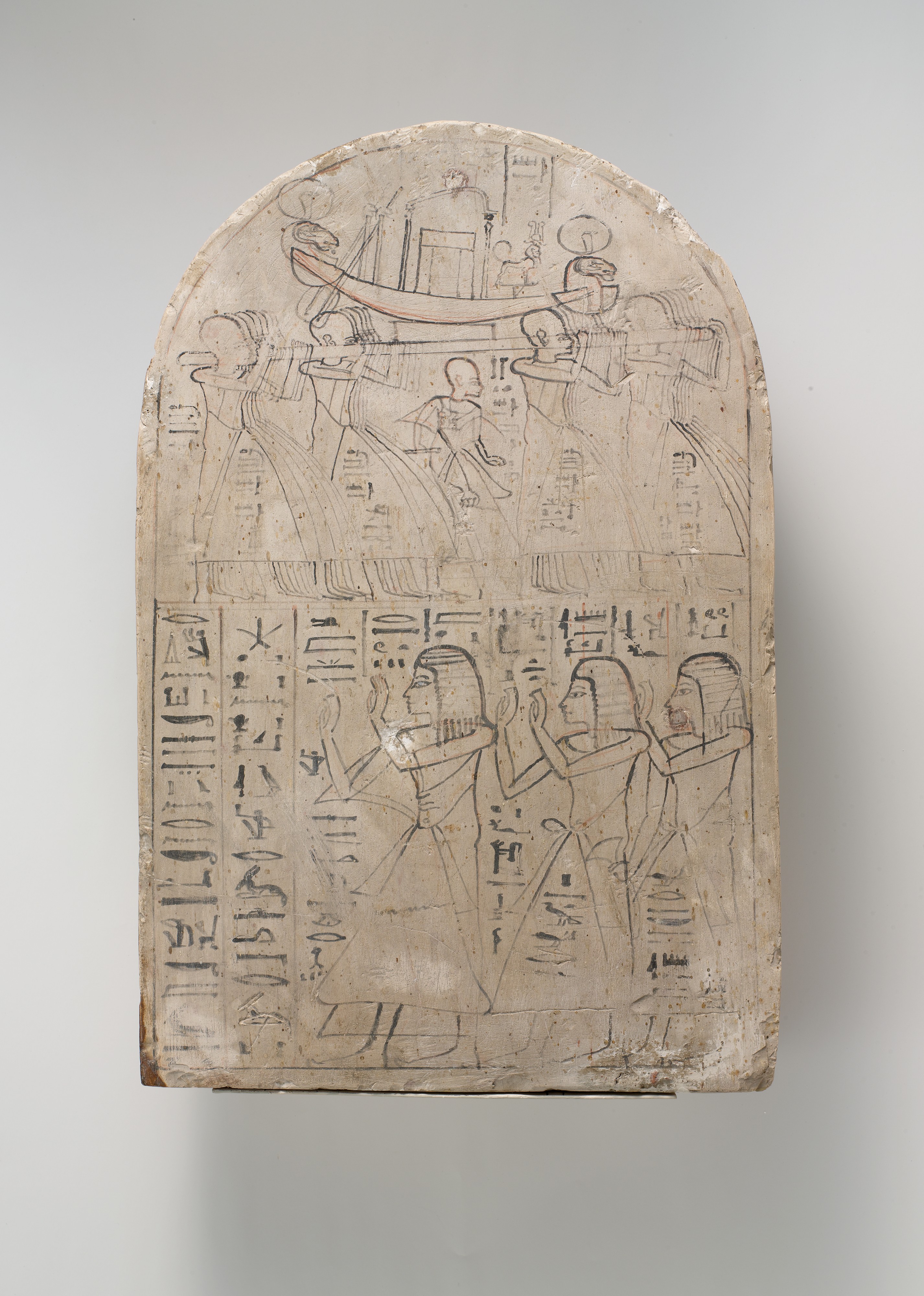
It began in the 12th century B.C., when Egyptian scribe Amennakhte drew the earliest surviving topographic map—a map which shows the shape of the land. It featured a winding line with large flat cones on either side—a valley bottom between hills. Maps would be similarly crude for the next three thousand years, with hills and mountains drawn as simple pictures, and approximately located at best.

But by the early 1800s, techniques were  much improved. Maps by William Clark of the Lewis and Clark expedition, and Charles Preuss, John C. Frémont's cartographer, added significantly to our geological knowledge. But they weren't perfect. Clark put today's Colorado too far north, thereby eliminating the Laramie Plains. Preuss's map was accurate for major features, but finer details could be unreliable. And on both maps, mountains were shown using hachures—short parallel lines suggesting relief but with little specific information. The third dimension remained elusive.

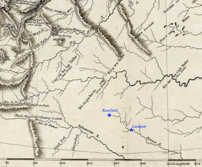
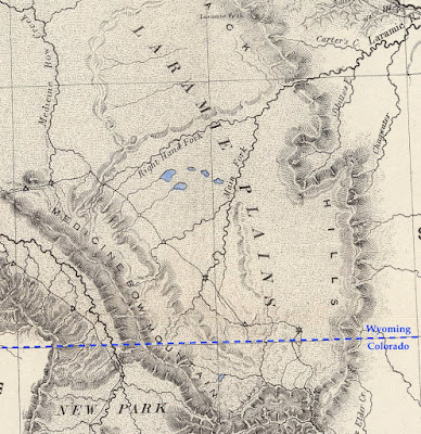
Excerpt from Preuss's map, showing the Laramie Plains crossed by the mysterious Right Hand Fork of the Laramie River (state line added). David Rumsey Map Collection.

After a grim hiatus, mapping resumes

Through the 1850s, the Army Corps of Topographical Engineers continued to explore and map the American West. The emphasis was route-finding, exemplified by the Pacific Railroad Survey—four concurrent expeditions looking for a way across the Rocky Mountains. But mapping came to a halt with the start of the Civil War, except as needed by the Union Army.

About five years after the War's end, the government began to invest again in maps. They were badly needed, for while France and England were putting final touches on national maps, and a dozen more countries had surveys in progress, the United States lagged far behind.

In 1870, a young US Army Lieutenant, George Montague Wheeler, presented a detailed proposal to map the United States west of 100º longitude (which roughly bisects the Dakotas). In need of post-war work, the Corps of Topographic Engineers jumped at the opportunity, and in 1871, Wheeler launched his "Survey West of the One-Hundredth Meridian."

George Montague Wheeler ca. 1872; National Portrait Gallery (SI)

Where on Earth are we?

Just a year later, on November 30, 1872, James H. Hayford of the Laramie Daily Sentinel reported, "Some parties are putting up some aparatus [sic] and a temporary observatory near our office today, under the supervision of Lieut. Wheeler [it's unlikely Wheeler himself was present], for the purpose of taking some astronomical observations to determine the latitude and longitude of this place."

Wheeler's men, John H. Clark and F.R. Simonton, had already made astronomical observations at two other locations in Wyoming Territory: Fort Fred Steele and Cheyenne, where they came up with a handy improvement to standard procedure. "A large wall-tent drawn over a framework formed the observatory. ... it was found to be an improvement to retain the ridge-pole [during observations] as a support against the violent winds so prevalent."

All in all though, working conditions were luxurious compared to those of the Frémont expedition 30 years earlier. Clark and Simonton could partake in the conveniences offered by the Laramie City, just four years old. Furthermore, their tent "was furnished with all the appliances of a field and temporary observatory, such as stools, stands, tables, and the like, and nothing was wanting as to equipment for first-class field-work. The [local] telegraph company furnished the line."

Longitude by wire

However, one thing hadn't changed since Frémont's time—longitude remained the greater challenge. There was no way to measure it directly. Instead, it was calculated based on the difference in time of specific celestial events in Laramie, and in Salt Lake City where longitude had been determined in 1869. [If you are thinking Laramie and SLC are in the same time zone, you're correct. But for this procedure, the surveyors used local time, also called solar time.]

To determine time difference, Clark and Simonton relied on the near-instantaneous communication of telegraphy. Time was recorded by chronograph—a combination of chronometer (clock) and paper-covered cylinder. Powered by a small battery, the cylinder turned exactly once per minute, as a pen marked a chronometer tick every second. After each minute, the pen-holder advanced slightly. The result was a piece of paper covered in parallel lines of tick-marks, a printed record of time.

As the chronometer clicked and the cylinder turned, the men added astronomical observations to the chronograph record, in real time. One man kept an eye on the heavens while also recording meteorological conditions and other notes on a paper form. When a star to be tracked approached, he notified the Observer at the telescope. At the moment the star entered the telescope's field of view, the Observer tapped a key wired to the chronograph, thereby leaving a mark on the paper. He did the same when the star passed out of view.

Drum chronograph by William Bond & Son, ca. 1850; "an instrument that touched a pen to a paper-wrapped cylinder to record both the beats of the clock and the instant of a celestial event, signaled when an observer pressed a telegraph key." (courtesy National Museum of American History)

This was only half the project. Each time the Observer in Laramie pressed the key, the signal also was sent via telegraph to a chronograph in Salt Lake City, overseen by their coworker, E.P. Austin. From the two sets of long paper records, they determined that stars passed over Laramie 25 minutes and 12 seconds before passing over Salt Lake City, putting the Laramie observatory at approximately 105º 35' 24" longitude (only about four blocks too far east according to Google Earth, not bad for field data!).

Star-gazing in Laramie, Wyoming in December

Obviously, Clark and Simonton were able to determine longitude much more accurately than Frémont had three decades before. But the work was challenging even so. They had constructed a rigid base for their instruments, but thundering trains shook them out of adjustment, and the metal contracted and expanded with temperature. Ink froze on the coldest nights, and the men's concentration waxed and waned with weather and amount of sleep.

So for accuracy, multiple stars were observed on multiple nights—but only when skies were clear at both ends of the telegraph line. To get enough observations, Clark and Simonton spent most of December in Laramie, "subjected to too much cold and too many wind and dust storms for any human brain and muscle to effect its best work in astronomy," according to Clark.

The future arrives

Wheeler's 1877 Progress Map; published sheets are brown. Laramie is near the east edge of Sheet 43. David Rumsey Map Collection.

In just eight years, Wheeler's crews surveyed 333,000 square miles; 75 topographic atlas sheets were produced (but no Laramie Sheet). The tradition of representing relief using hachures continued, often with the addition of spot elevations (numbers). But there was a revolution afoot. During the same time, John Wesley Powell and Almon Harris Thompson, of the US Geographical and Geological Survey of Territories, were producing topographic maps using contour lines, which connected points of equal elevation. These maps showed the shape of the land in greater detail and more accurately.

Excerpt from Wheeler's hachured "Central Colorado Atlas Sheet # 62a" (1878). Click to view scattered spot elevations. David Rumsey Map Collection.
Excerpt from Powell and Thompson's contour map: "Green River from the Union Pacific Rail Road [WY] to White River [CO]" (1876); green marks irrigable land. David Rumsey Map Collection.

Mapping the Laramie Plains

In 1878, Wheeler's survey and three others were replaced with a single agency, the United States Geological Survey (USGS), tasked with "classification of the public lands, and examination of the geological structure, mineral resources, and products of the national domain." In 1882, its responsibilities were expanded to include preparation of a national map.

A decade later, on August 26, 1892, the Laramie Boomerang had great news. USGS surveyors Frank Tweedy and James McFarland had arrived and would "commence work upon the topography of this section of the country"—part of the national map of the United States already ten years underway. "This vast map will take at least 25 more years to complete [it would be more like a century] ... [and] when completed, would, if spread out, cover a little over 3/4 acre ..."

Obviously impractical, the great map had been divided into sheets, each named for a prominent local feature (for example, the Laramie Sheet). Vertical relief would be shown with contour lines, now recognized as far better than hachures, which cluttered maps, provided limited information, and were expensive to draw and print (almost as costly as fieldwork!).

No need to bother with longitude

The point established 20 years earlier, by Clark and Simonton of the Wheeler survey, did not go to waste. Tweedy and McFarland used it as the starting point for their survey. From it, they ran a baseline along the bed of the Union Pacific Railroad north of Laramie for 2.5 miles. The ties supported their tape nicely, and there was no brush to clear.

Their methods show how far accuracy had come. The tape was held at 20 lb. tension using a spring balance at one end. After every four lengths, they remeasured and calculated the average. The metal tape was precisely 300 ft long, but that was at 62º F. So they tried to work mainly on cloudy days or at night to minimize expansion and contraction. They also kept a record of air temperature, for later adjustment (0.02289456 inch per degree).

From the baseline, Tweedy and McFarland established points across the Laramie Plains through triangulation—measuring angles. No longitude determinations needed! And no trees obscured their view. They measured distance, direction and height of prominent features—mountain summits, ends of ridges, forks of creeks, and so forth. They also made detailed sketches of landscapes.

After several months, Tweedy boarded a train and transported the data and sketches to Washington DC, where he and others would turn them into a map.

Reading the lines

Six months later, in March of 1893, County Surveyor W.O. Owen  received preliminary sheets for review (Owen had mapped Albany County the decade before, using shading to show relief). According to the excited Boomerang reporter who saw them, "The contour lines are so explicit that almost every cañon and hill can be determined at a glance."

Well, maybe. For many people, contour maps were new and counterintuitive. So the USGS provided an explanation with each map to help users interpret the winding lines. "Each contour [line] passes through points which have the same altitude. One who follows a contour on the ground will go neither uphill nor downhill, but on a level ... a succession of these contour lines far apart on the map indicates a gentle slope; if close together, a steep slope; and if the contours run together in one line, as if each were vertically under the one above it, they indicate a cliff."
Excerpt from first Laramie Sheet (USGS 1895). Increasingly-close lines east of Laramie are foothills of the Laramie Range. Southeast of town, Red Buttes have dense lines on their steep sides, and none on the flat tops. Gentle terrain (lines far apart) stretches west for miles before meeting the dark steep face of Sheep Mountain.

Even the depressions of the Laramie Basin were mapped using contour lines. In fact, they are textbook examples—literally! They appeared as Plate 170B in "The Interpretation of Topographic Maps" (USGS 1908). "In many parts of the country are depressions or hollows with no outlets. The contours, of course, surround these, just as they surround hills. The small hollows known as sinks are usually indicated by hachures, or short dashes, on the inside of the curve."
Excerpt from "Plate 170B: Special types of lakes: part of Laramie Sheet" showing hollows or sinks of the Laramie Plains (USGS 1908).

Sources

These are some of the more interesting sources I found:

David Rumsey Map Collection (kinda like the Hotel California—hard to leave)


Evans, R.T., and Frye, H.M. 2009. History of the topographic branch (division): U.S. Geological Survey Circular 1341, 196 p. (PDF; unfortunately illustrations are missing)

For more about longitude determination, see the great Wikipedia article: History of longitude, especially "Land surveying and telegraphy". True enthusiasts will want to read "Longitude by Wire: Finding North America" by Richard Stachurski (2009).

Cohen, Paul. 2002. Mapping the West; America's Westward Movement 1524-1890. Hardcover. 65 fascinating maps and their stories (plus a very interesting account by David Rumsey of how he got hooked on maps).

This post is an expanded version of the second of two articles about mapping the Laramie Plains, my most recent contribution to the "Laramie History" column in the Laramie Boomerang.

Saturday, March 27, 2021

Mapping the Laramie Plains I: in pursuit of the 3rd dimension

"... almost every hill and cañon can be determined at a glance!" From first Laramie, Wyoming Sheet (USGS 1895; public domain).

In the spring of 1893, Albany County Surveyor W.O. Owen received a set of preliminary maps from the US Geological Survey for review. Owen had known what to expect, but the others who saw them were surprised. "The maps are of a very interesting character ...", wrote a reporter for the Laramie Boomerang, "almost every hill and cañon can be determined at a glance!"

Indeed, the new map was astonishing—mountains and depressions around Laramie had been clearly mapped using squiggly lines! But this achievement was long in coming. For millennia, mappers had struggled to show topographical relief, to capture the third dimension on a two-dimensional sheet of paper.

Line + cones = valley
From Amennakhte's map for pharaoh Ramesses IV. Public domain.
In 1160 B.C. Scribe-of-the-Tomb Amennakhte made a map for Egyptian pharaoh Ramesses IV, who was planning a trip to quarry sandstone suitable for statues. On papyrus, he drew a broad winding line with bumpy cones lying flat on either side. With a bit of imagination, we see this is a valley lined with hills.

Amennakhte's hills look terribly crude to our eyes. Yet they aren't all that different from those appearing on maps for the next two millennia. As late as the 16th century, during early exploration of North America, mountains were shown as oversized cones, though sometimes shaded to suggest depth. Often their locations were based on distant views from sea, or rumors.
Leftmost figure is "Royal Scribe of the Place of Truth" Amennakhte. Carving on limestone, ca. 1184–1070 BC. Metropolitan Museum of Art; public domain.

Lewis & Clark map new territory

The next centuries brought significant improvements in surveying and mapping, fortunately. In the early 1800s, the young United States was in desperate need of good maps. The Louisiana Purchase had doubled the country's size. Little was known about the new territory—not even its size, nor how to traverse it.

In May 1804, the Corps of Discovery Expedition, led by Meriwether Lewis and William Clark, headed up the Missouri River in search of a route to the Pacific Ocean. In preparation for the trip, Lewis was trained in celestial navigation. President Thomas Jefferson personally provided instructions for mapping:
"... you will take observations of latitude & longitude, at all remarkable points on the river [e.g., rapids, river mouths, islands]. The interesting points of the portage between the heads of the Missouri, & of the water offering the best communication with the Pacific ocean, should also be fixed by observation ..." [Jefferson assumed they could reach a west-flowing river by carrying their boats overland.] "Your observations are to be taken with great pains & accuracy, to be entered distinctly & intelligibly for others as well as yourself, to comprehend all the elements necessary, with the aid of the usual tables, to fix the latitude and longitude of the places ..."

Lewis and Clark faithfully executed Jefferson's instructions, for three years, four months, ten days and 8000 miles.

William Clark, explorer, soldier, Indian agent, territorial governor & cartographer; portrait by Charles Peale 1810. Public domain.
Clark's map reveals a multitude of mountains

William Clark took on the job of mapmaker. In addition to the Expedition observations, he used information from explorers, trappers, natives, and earlier maps to include areas not covered by the expedition. His first map showed the Corps’ route in great detail and was necessarily huge—50+ large sheets. He then produced a single map 52 inches long and 31 inches wide, engraved and published in 1814: “A Map of Lewis and Clark's Track, Across the Western Portion of North America ...”

Among the discoveries visible on Clark's map is the structure of the Rocky Mountains. They are not a single long ridge as previously thought, but a complex system of mountain ranges and foothills. In fact, after reaching the headwaters of the Missouri, the Corps of Discovery had to travel for weeks on horseback and foot to reach west-flowing waters. A portage across the Rockies was out of the question (click on image below).
Lewis & Clark's Track. Courtesy David Rumsey Map Collection (available in high resolution).
If you click on these images, you can see that mountains were drawn with hachures—short parallel lines looking something like eyelashes. Length and curvature gave a sense of height and steepness. Hachures were denser and darker on east and south slopes of ranges, suggesting a third dimension.

Clark's map was mostly accurate by the standards of the day. But there is a glaring error in the southern part. The Laramie Plains and surrounding mountains are missing! Little was known about the territory that would become southern Wyoming, so future Colorado and Kansas were moved north to fill the gap. This is why the Kanzas [sic] River was shown flowing where Rawlins and Laramie are today.

Today's southern Wyoming, from Lewis & Clark's Track. The Arkansas and Kansas Rivers were mapped hundreds of miles northeast of their true location, putting them in the vicinity of modern-day Rawlins and Laramie (added). Courtesy David Rumsey Map Collection.

The Pathfinder puts the Laramie Plains on the map

John C. Frémont "on the Rocky Mountains"; public domain.

In July 1843, a small contingent of the US Army Corps of Topographical Engineers climbed out of the canyon of the Cache-à-la-Poudre River, where they had hoped to find a route over the Rocky Mountains. Instead, they crossed the broad divide to the north.

In command was a young ambitious lieutenant—John Charles Frémont, the Pathfinder. This was the second of five expeditions he would lead through the American West, each time making significant contributions to geographical knowledge. He also would be court-martialed, lose a presidential election, squander large sums of money in mining schemes, and die in poverty. But all that was far in the future on that lovely summer day when the Laramie Plains came into view.

"The weather was pleasant and cool, we were disturbed by neither musquitoes [sic] nor flies; and the country was certainly extremely beautiful," Frémont would write in his report. "The slopes and broad ravines were absolutely covered with fields of flowers of the most exquisitely beautiful colors. ... As we emerged on a small tributary of the Laramie river, coming in sight of its principal stream, the flora became perfectly magnificent; and we congratulated ourselves, as we rode along our pleasant road, that we had substituted this for the uninteresting country between Laramie hills and the Sweet Water valley."

Challenges: stones, sagebrush, longitude

That evening, they camped on the Main Fork of the Laramie River, where Frémont took astronomical readings to determine latitude and longitude. While latitude seems to have been accurate, his calculation of longitude put them too far west, in the Medicine Bow Mountains near Lake Owen according to Google Earth. But that's not surprising. Estimating longitude was difficult, requiring careful tracking of stars with a precision telescope and a chronometer that kept steady time, or at least lost time at a steady rate.

For three days the party traveled northwest along the Medicine Bow mountain [sic]. The going was easy at first, but near the mountain they were slowed by large round stones in the soil. Equally difficult were ridges "made extremely rough by the stiff tough bushes of artemisia tridentata, in this country commonly called sage" [as it is today].

On August 2, they camped on the Medicine Bow River near "an isolated mountain called the Medicine Butte [Elk Mountain], which appeared to be about 1,800 feet above the plain, from which it rises abruptly, and was still white nearly to its base with a great quantity of snow". Frémont made more astronomical observations, this time including "an immersion [eclipse] of the first satellite of Jupiter." Even so, the calculated longitude again put them too far west.

After passing south of Elk Mountain, the party dropped down to the North Platte River, followed it to the Sweetwater, and continued on to California and Oregon. They would return home in August 1844, after about 15 months and 10,000 miles of travel.

A "meagre and skeleton" but valuable map (Frémont & Preuss 1845). High resolution version here, courtesy David Rumsey Map Collection. 

Dramatic report, spectacular map

Frémont wrote a colorful report about his adventures, with the help of his wife, Jesse, whose father—the powerful Senator Thomas Hart Benton—had secured funding for the expedition. Ten thousand copies were published the following year, to rave reviews. Included was the spectacular “Map Of An Exploring Expedition To The Rocky Mountains” measuring 52 x 30 inches, and stretching from the Missouri River west to the Pacific Ocean and from Los Angeles north to Mt. St. Helens.

However, much of the map was blank—to Frémont's credit. In a Notice to the Reader, he explained: "The map may have a meagre and skeleton appearance to the general eye, but is expected to be more valuable to science on that account, being wholly founded upon positive data and actual operations in the field." Indeed, the map is now considered a milestone, having set a new standard of cartographic accuracy for the American West.

The mapmaker was Charles Preuss, a trained surveyor and topographic artist from Prussia. He would accompany Frémont on three expeditions, making "continuous topographical sketches of the regions through which we passed, and which were never interrupted by any extremity of fatigue or privation" (Frémont's words). The large beautiful maps secured his reputation as a great cartographer.

Cartographer Charles Preuss, date unknown. Source (without attribution).

Laramie Plains up close

In the 30 years since publication of the Lewis and Clark map, techniques for representing relief hadn't changed all that much. Preuss also drew mountains using hachures, though in much greater detail. In the excerpt below (click to view), small narrow drainages are visible on mountains slopes, and low ridges and buttes dot the plains. Preuss varied hachures to show height and steepness. Lower ridges were drawn with shorter lines. Denser darker hachures indicated steeper slopes—for example Laramie Peak (top center of map) and, a short distance southeast, the canyon where the Laramie River crosses the Black Hills (now the Laramie Mountains).

From the 1845 map by Frémont and Preuss. Stars mark points where longitude and latitude were determined. At triangles, they measured the sun's height at noon to estimate latitude.

However, if we continue our examination, we're soon confused. Is that low mountain range paralleling the Medicine Bows Jelm and Sheep Mountains? Doesn't look right. Nor does the ridge east of the Main Fork. Most puzzling is the “Right Hand Fork” which (supposedly) joins the Main Fork of the Laramie River before it enters the canyon. Our history buffs still haven't solved this mystery.

Errors at this scale aren't surprising. With the great expanse of unknown territory ahead, there was little time for finer details, and though Preuss' map was highly accurate in its time, it's a far cry from the "very interesting map” showing every hill and canyon, which would so excite a Boomerang reporter 50 years later ...

[More to come in Part II.]

This post is based on the first of two articles about mapping the Laramie Plains, my most recent contribution to the "Laramie History" column in the Laramie Boomerang.

Thursday, October 15, 2020

Our Long Love Affair with the US Mail

Library of Congress (LOC)
Communication is among our greatest desires. Being hyper-social animals, we demand more information, more news whether good or bad, more messages of affection, assurance, sympathy and love, and we want them to travel ever father, faster, and more conveniently. This didn't arrive with the digital age. We've always been that way.


Your Mail was Delivered by Carrier Today!
(and fresh off the east-bound train)
Hollis Marriott
Laramie Boomerang, September 13, 2020

Laramie, Wyoming was born in the spring of 1868, when Union Pacific Railroad crews arrived with their entourage of gamblers, hustlers, saloon keepers, and ladies of the night. But it wasn't long before signs of civilization began to appear. Just two years later, a literary society and library were established, and Louisa Swain made political history when she voted on September 6. In 1874, the Grand Opening of the Laramie Opera House was a resounding success. No doubt Laramie would soon be a booming metropolis!

But twenty years later, mail service—key to community health—remained primitive. Residents and businesses were forced to go to the post office just to find out if they even had mail. All agreed Laramie deserved better. Information and news were of great import then, just like today. Letters were the era's text messages and tweets.

Connecting the Nation
In 1775, our de facto national government—the Second Continental Congress—was focused on winning the Revolutionary War. Toward that end, a system for secure delivery of letters and intelligence was created under the leadership of Pennsylvania delegate Benjamin Franklin, who was Postmaster for the Crown until he was fired for colonial sympathies. After the Declaration of Independence in July 1776, the system and Franklin became the new nation's postal service and postmaster.
In 1847, Ben Franklin would appear on one of the nation's first postage stamps (trial design here). For 5¢, a half-ounce letter could travel up to 300 miles. National Postal Museum (NPM)
At the end of the War, demand for postal service did not slow one bit. Instead, it increased at an ever-accelerating pace. The nation was expanding by leaps and bounds—into the Midwest, up and down the Mississippi River, west to the Rocky Mountains, and then to the Pacific. Between 1790 and 1860, the population grew from 3.9 million to 31.4 million, an eightfold increase. During that same time, the number of post offices increased 380-fold—from 75 to 28,498!

Why this great disparity? Because in battles over spending that accompanied the nation's growth, advocates for improved communication generally won. When territories, states and communities petitioned for mail service, they usually got it, regardless of cost. Connecting the nation had become the Post Office Department's top priority.

We Want Speed, & Convenience Too!
One factor in the postal service's skyrocketing popularity was innovative use of technology, especially "Mail by Rail". U.S. railroads were designated postal routes in 1838, but it was the rapid expansion of rail lines after 1860, coupled with efficient use, that gave wings to the mail. Railway Post Offices, introduced in the 1860s, greatly accelerated delivery. In specially-designed cars on high speed passenger trains, postal staff sorted mail as they criss-crossed the country.
Postmaster positions outgoing mail for pickup. The mailbag would be snatched by a catcher arm (steel hook and crane) as the train rolled by, avoiding the need to slow down. NPM
Greater convenience was another goal. Before 1863, "delivery" meant from post office to post office (a few cities offered home delivery for one or two cents more). Then in July of that year, free home delivery was introduced in large cities.

Not surprisingly, it was hugely popular and in great demand. Many communities petitioned for free postal delivery—but only if their population was at least 10,000, and annual postal receipts greater than $10,000. Additional requirements included sidewalks and crosswalks, streets with names and lights, and a numbering system for buildings.
The wonderful convenience of home delivery. NPM

Will Laramie be Among Those Selected?
Free postal delivery arrived in Wyoming Territory in 1887, but only in Cheyenne. On August 6, the Cheyenne Daily Leader, arch-rival of the Laramie Boomerang, was beside itself with pride, proclaiming: "Cheyenne is beginning to put on all the frills of a full-blown metropolis." The Boomerang took this in stride. "At the present rate of growth that marks Laramie, this city will be entitled to free delivery inside of two years."

Three years later, in 1890, Laramie still was without delivery service, but there was hope. In October, N.E. Corthell reported to the Board of Trade (chamber of commerce) that Congress had allocated $10,000 to test free delivery in towns with populations between 5000 and 7000. The Board and the Boomerang both were confident that Laramie would be selected. "Cheyenne already has free delivery and Laramie is the next town of importance in the state, and each of the new states will at least be given one test town."

November 7 brought more good news: "Very Encouraging Outlook for a Trial of the System." W.D. Thomas, Secretary of the Board of Trade, happened to be an old friend of John Wanamaker, the nation's Postmaster General. When Thomas contacted him about delivery service in Laramie, Wanamaker expressed interest, requesting more information—such as whether one carrier would suffice.

Unfortunately, Corthell's report was not entirely correct. To be eligible, a town had to have 300 to 5000 residents. Late in November, the Board of Trade received official notification that Laramie was too big. However, because postal receipts were close to $10,000, it should qualify under the regular law.

Try, Try Again
In early 1891, systematic numbering of houses and businesses had begun. "Laramie is expected to have the free postal delivery system established during the coming summer" announced the Boomerang. Annual postal revenue currently was $9849.81. Surely it would reach the required $10,000 "if Postmaster [Richard] Butler receives his supply of stamps in time. He is almost out."

In June there was another delay, due to other unmet requirements. Mail deposit boxes needed to be installed across the city, and the post office still lacked work space for carriers. Postmaster Butler should "commence a great big rustle at once," advised the Boomerang.

The article ended with an interesting question. "There are many applicants for the three carrier positions, and the number is increasing every day. Among the number are some ladies. How will the ladies wear uniforms?"

Yet Another Obstacle
Early in 1892, disturbing letters appeared in the Boomerang, from Wyoming's Congressman C.D. Clark and Senator F.E. Warren. Both noted that Laramie's postal revenue was insufficient for free delivery, though not by much ($150.19). But even if it were to increase, the city likely would be rejected. Twenty communities with much larger populations and revenue were on the waiting list.

Yet Senator Warren ended on an optimistic note. Postmaster Wanamaker had assured him that the small deficit in receipts could be overlooked. And after Warren pointed out he was asking on behalf of just one community in the state, he was given Wanamaker's "honest assurance that Laramie's claim should be considered among the very first when proper means have been secured."

Another obstacle arose five months later. New regulations prohibited funding of additional delivery service in Congressional Districts where at least one city already was so served. In 1892, as now, Wyoming had a single district, and it had a city with free delivery—Cheyenne.

Yet Warren remained hopeful; it seemed impossible to dampen his optimism. "... today at the department, I was assured that ... we shall have early and friendly attention. I feel quite sure tonight of final success and think we will be attended to very soon."

He was correct. In late September, the Board of Trade received a telegram: "Order signed today establishing free delivery at Laramie to commence December 1st, with three carriers. Congratulations. F.E. Warren."
Senator Francis E. Warren would use power and pork-barrel politics to secure millions of dollars for Wyoming. He finally left office in 1929, when he died (age 85). LOC

Limited Funding, Limited Service
Initially, only the main part of Laramie had free postal delivery—from the railroad tracks east to 8th St., and from Clark St. south to Park Ave. In response to complaints, Postmaster Butler explained that districts were designed by the Postal Inspector in Cheyenne. If the program was successful (it was), funding and coverage likely would expand (they did).

In Laramie, interest in and enthusiasm for the postal service and everything it provided was tremendous—evidenced by the lengthy Boomerang article the day free delivery was launched. District boundaries were described in detail, and locations of mail drop boxes listed. The carriers' schedule occupied five paragraphs.
Laramie postal districts with carrier names, as of Dec. 1, 1892. Blue dots mark deposit boxes, post office in pink (added to 1894 map).
Mail would be delivered Monday through Saturday, each carrier making three rounds per day. This may seem odd given the sizable portion of town excluded from service, but multiple daily deliveries were common nationwide. The goal was to get a letter to the customer's door as soon as possible (like Walmart's Delivery Express).

Starting at 7:15 a.m., carriers made deliveries in the business district via a special route, and collected mail for the west-bound train, which departed at 9:35 a.m.. After mail brought to Laramie by this train was "overhauled" (sorted), carriers started their second round, at 11 a.m., this time covering their assigned districts. The third and final round commenced at 4 p.m., after mail from the east-bound train and local mail had been sorted and was available for delivery. Each man again covered his entire district.

During this final round, carriers also gathered mail from 18 conveniently-located drop boxes—no longer would it be necessary to go to the post office to mail a letter! A letter could be sent at no charge if the recipient had a box at the Laramie Post Office. Otherwise, the sender attached a 2¢ stamp.
In the 1890s, 2¢ was the cost of 1st-class domestic postage, no matter the distance. George Washington has appeared on more U.S. postage stamps than any other person. NPM

Feel that Metropolitan Air?
On December 6, 1893, Laramie's carriers and Postmaster Butler gathered at Wood's restaurant for oysters, quail, lobster salad, Zinfandel a la mode biscuits, and much more—to celebrate a year of successful free postal delivery. For a full year, they had sorted and delivered several hundred pounds of mail daily, bringing excitement and disappointment, joy and sorrow, good news and bad to a large portion of the population. "The service has given remarkable satisfaction" reported the Boomerang, as well as providing Laramie with "that additional metropolitan air." It was sure to continue!


This is my most recent contribution to the Laramie Boomerang's History series. For more information about the birth and evolution of the US Postal Service, see the excellent United States Postal Service: An American History (2020, PDF available here).
LOC