Showing posts with label Great Plains geology. Show all posts

Wednesday, May 25, 2016

Rock Gardens at Scotts Bluff

Scotts Bluff mid-distance, viewed from the Wildcat Hills in northwest Nebraska.

Between 1914 and 1918, concerned citizens of Nebraska contacted the Department of the Interior in Washington DC four times—twice by inquiry and twice by petition. They wanted the president to make Scotts Bluff a National Monument, to honor its importance as a landmark on the Oregon Trail. Their wish was granted by President Woodrow Wilson, who created Scotts Bluff National Monument on December 12, 1919.

History buffs weren’t the only beneficiaries. The rocks are full of geological evidence from 25-30 million years ago—when little horses, tiny camels, rhinos, ruminating hogs, and other mammalian beasts roamed the vast savannas, and volcanic ash rained from the sky. And there are treats for plant lovers too. When I visited, I found beautiful rock gardens with colorful spring wildflowers growing in soft pale rock.
Evening primrose in an erosional landscape (Oenothera caespitosa).
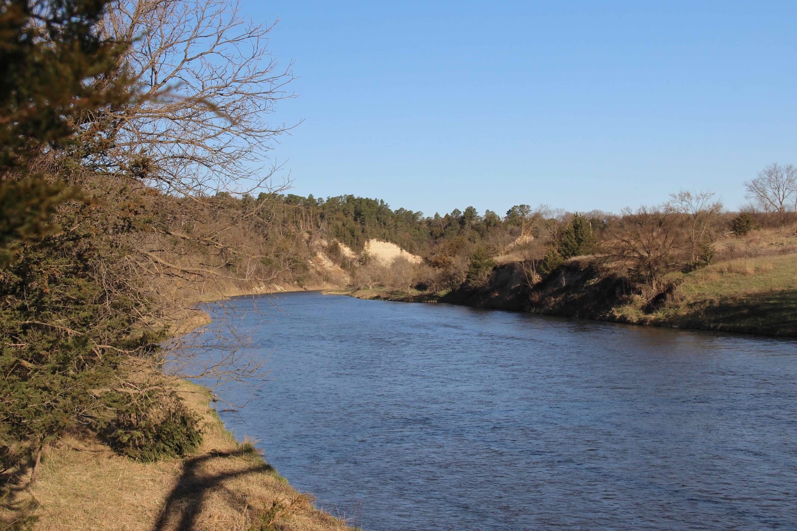
The summit of Scotts Bluff stands 800 feet above the North Platte River—its maker. The river has taken advantage of the soft rocks to carve this landmark and others nearby. But there are downsides to the Sculptor’s hand. For example, part of the trail from the Visitor Center to the summit is closed due to rock fall. The most alluring section—where a tunnel goes though Saddle Back Rock—was inaccessible. Bummer!
The Master’s work is never done.
After hiking the open sections of the trail, I chatted with park staff who recommended walking the park road when it’s closed to traffic—before 8 am or after 5:30 pm (7:30 in summer). This is a greater opportunity than you might think. There's plenty to see, but when driving it’s impossible to look at anything as there’s no place to stop. Sauntering is a much better way to enjoy the scenery, plants and rocks along the road.

Rock gardens were common, but unfortunately it was quite windy, and only a few of my plant photos were in focus. The rocks were more cooperative.
Narrow-leaved musineon (Musineon tenuifolium) with prickly pear cactus (Opuntia sp.).
The musineon (also called slender wild parsley) was common in the rocks at the summit.
Evening primrose in the evening. The closed pink flowers have already bloomed.
Prairie golden peas (Thermopsis rhombifolia) were a bit stunted, but not much considering their habitat.
Bonsai ponderosa pine—hardly ponderous (Pinus ponderosa).
Locoweed (Astragalus sp.) on calcareous concretions! (more on this below) At least thirty species of Astragalus grow in Nebraska. Only a few are true “loco” weeds, i.e. toxic.
The Sculptor is visible in the distance—the North Platte River. Pine Ridge forms the horizon.
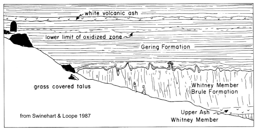
Near the summit, road cuts and erosion have exposed hard pipy (pipe-shaped) concretions in rocks of the Monroe Formation. They formed after sediments were deposited, “by precipitation of calcium carbonate from groundwater” (Maher’s Roadside Geology of Nebraska). The elongate concretions all are oriented northeast-southwest, both at Scotts Bluff and north of the river at Pine Ridge. Why? … apparently it's still a mystery.
Concretions stick out because they're harder than the surrounding rock and resist erosion.
Pipy concretions all in a row.

It was Will Maupin who first suggested a paved road to the summit of Scotts Bluff. This was sometime between 1920 and 1924, when he was serving as the first Monument Custodian at a salary of $1 per month (he also was editor of the local newspaper). Road construction began in 1932, and continued off and on until September 19, 1937, when the paved road was opened to the public (source).
Boring the lower tunnel in the 1930s (NPS; no source given).
Lower tunnel today, from middle tunnel.
The closed road is popular with runners and walkers, both human and canine. Distance is three miles round trip. The steepest slopes have been plastered over, but rocks still fall.
"Plastered" slope (my term), with drain pipes at base.
Looks like Park staff have to clear rocks from the road on a regular basis.
Scotts Bluff from the air, courtesy Google Earth. Click on image to view road and trails.

Friday, May 20, 2016

A Mysterious Contact (Letter to the Earth)

Scotts Bluff in northwest Nebraska, viewed from the Wildcat Hills where I recently camped.

It hadn’t been dark long when a loud wailing awoke me. I jumped from the tent before realizing it was just the wind in the ponderosa pines, the noisiest of our pines. Something about the long needles … I was trying to remember … but then it suddenly stopped. Dead silence. How eerily odd. Was it really the wind?

I crawled back into the tent and slept fitfully, dreaming vividly. At one point, I climbed Chimney Rock—improbable enough in itself but even more bizarre, on the summit I met a translucent man jumping up and down waving his arms, gratified to have an audience:
“The surface is here washed out into the form of domes, towers, churches, and fortifications, and it is hardly possible to persuade oneself that the hand of art has not been busy here.”
The dream transitioned seamlessly into reality, as mine often do. I awoke, but the ghostly lecturer continued on, unseen:
“Chimney Rock shoots up its tall, white spire from one hundred to one hundred and fifty feet. The strata are perfectly horizontal, and, therefore, we may infer that the surface of the whole country was originally on a level with the summit at least, and that these landmarks are monuments left after erosion.”
“The most striking examples are in the vicinity of Scottsssshhhhh …
As the sun rose, the voice faded into silence.
Chimney Rock; horse stands on a bed of volcanic ash (Darton 1903; arrow added).
I got up, grabbed the stove and coffeepot from the car, and headed for the picnic table. There I found a book held open by a rock! Roadside Geology of Nebraska was turned to page 245. The black-and-white photo of Scotts Bluff had been annotated in an old-fashioned hand, and an arrow pointed to the lower part of the rock face: “You must examine carefully this mysterious contact.”


At Scotts Bluff National Monument I was greeted by good news and bad. The trail to the crest passes very close to the mysterious contact, and dogs can go too! But the trail was closed until further notice, due to a large rock slide.
Saddle Rock Trail, lower trailhead; destination is was the more distant rock ridge.
Rock slide across trail. Managers are debating whether to repair the trail or close it permanently (NO!).
We hiked three-quarters of the way up, to the lower barricade, and then drove to the top and hiked down to the upper barricade. In neither case could we examine the mysterious contact carefully. But we were close enough for photos, in fact tantalizingly close … if only … should I? … sigh, no … I’d be in plain view and besides, the staff had been so friendly and helpful.
Trail goes through a tunnel in this rock ridge ...  you can see why I was lusting after this hike!

As the ghostly lecturer had explained, Scotts Bluff is an erosional remnant that was left standing as the North Platte River eroded and carried away surrounding rocks. It's one of several of local remnants curious enough to be named: Dome Rock, Sentinel Rock, Crown Rock, Chimney Rock and more.
Dome Rock, viewed from the top of Scotts Bluff.
Saddle Rock at east end of Scotts Bluff; view from South Overlook.
For travelers on the Oregon Trail—who had endured day after day after day of heat, dust and monotony crossing the Great Plains—these distinctive buttes, bluffs and monuments were a welcome relief. People often paused for a moment before trudging on westward—“in wonder to see such a natural marvel and many remembered it long after their journeys were over” (source).
“The landmarks indicated our progress and helped to break the monotony – like the milestones along the journey of life, there was one less to pass.” —Phoebe G. Judson, near Scotts Bluff, 1853 (from interpretive sign at Scotts Bluff NM)
“Mitchell Pass” (now part of Scotts Bluff NM) by William Henry Jackson, 1866. He was working as a bullwhacker on a wagon train. From Scotts Bluff NM, used with permission.
More than 250,000 hopeful emigrants passed Scotts Bluff between 1843 and 1869!

Rocks in the Scotts Bluff area started as sediments eroded off the Rocky Mountains roughly 35 to 20 million years ago. They were carried down by streams and deposited in a great wedge to the east. In all, there were three major pulses of deposition; rocks from the first and second are exposed at Scotts Bluff. These are the Brule and Gering Formations (geologists assign such names to distinctive rock units).
Oldest to youngest rocks from bottom to top (as we would expect): Brule Formation of the White River Group, and Gering Formation and others of the Arikaree Group.
Time stratigraphic chart; vertical bracket bars show rocks exposed at Scotts Bluff NM; source.
At Scotts Bluff, the Brule Formation is mainly volcaniclastic siltstone, but includes a layer of regular sandstone and siltstone. The Gering is volcaniclastic sandstone. The white layers in both are volcanic ash beds. The darker brown zone is referred to as “oxidized” but I could find no explanation as to how this came to be.
Between the Brule and Gering is where things get interesting—in fact, mysterious. There is an unconformity here—a gap in the rock record of perhaps four million years (source). The Brule episode of deposition ceased, and four million years of erosion (or at least non-deposition) passed before the next pulse of sediments came down from the Rockies. We love unconformities—they’re often easy to see and it’s so cool to be able to read the past from the rocks! And there’s something especially intriguing about this one.

Southeast and downhill from the tunnel, the Brule–Gering unconformity or contact is nicely exposed. Elsewhere in the park it's flat with little relief, but here it’s wavy!
Brule–Gering contact does The Wave.
Brule–Gering contact below tunnel (upper left). Note people on slope (six feet tall); source.
Zooming in on the undulations from the trail across the draw.

How did this wavy surface come to be? In what kind of environment do we find such forms? Are they erosional features of some kind?

Answer: Apparently no one knows. In Roadside Geology of Nebraska, Maher and colleagues offer two alternatives. Maybe the undulations are old erosional features on the Brule surface that were buried by younger Gering sediments. Or maybe Brule sediments moved under the weight of Gering sediments (soft sediment deformation).
Are those also undulations in the white ash layer above?! (click on image to view) Another mystery,

I sat on a wayside bench, reading and rereading, considering the alternatives. I was trying to imagine the two scenarios when a familiar voice reappeared:
“To enable the mind to realize the physical condition of our planet during all these past ages is the highest end to be attained by the study of geological facts. It has been well said by an eloquent historian that he who calls the past back again into being, enjoys a bliss like that of creating.” —Ferdinand Vandeveer Hayden, 1871, Geological Survey of the Territories, Ch. 8 From Omaha to Cheyenne
Ferdinand Vandeveer Hayden, head of the US Geological and Geographical Survey of the Territories (1867-1883); source.

Sources

Hayden, FV. 1871. Preliminary report on the geological survey of Wyoming, and portions of contiguous territories. Washington, Government Printing Office.

Maher, HD, Jr., Egelmann, GF, and Shuster, RD.  2003.  Roadside geology of Nebraska.  Mountain Press Publishing Company.

Swinehart, J. B., and D. B. Loope. 1987. Late Cenozoic geology along the summit to museum hiking trail, Scotts Bluff National Monument, western Nebraska. GSA Centennial Field Guide—North Central Section. pp 13-18. PDF


Tuesday, May 3, 2016

The Great Aquifer is Leaking

“Visit Nebraska. Visit Nice.” (more here)

Nebraska is nice, as the Nebraska Tourism Commission says, but why are they so modest? It’s more than nice—spectacular even. I especially like the immense vistas—maybe to the edge of the world! Maybe if I keep going I’ll float off to join the birds and the clouds, and we can sail across the beautiful blue Nebraska sky. Such thoughts cross my mind as I drive through open rolling country for miles and miles and miles.
It was Willa Cather who suggested that the Great Plains lead to the edge of the earth.
And something equally remarkable lies hidden from view. Cross Nebraska and you cross miles and miles of water-soaked consolidated sand just a few hundred feet below the surface—one of the most important aquifers in the world. Two-thirds of the water in this great aquifer—650 trillion gallons**—lies under Nebraska.
“Saturated thickness of the Ogallala Aquifer in 1997 after several decades of intensive withdrawals.” Note that the aquifer is most extensive and thickest (dark blue) in Nebraska (USGS via Wikimedia).
The Ogallala Aquifer is so-named because most of the water-bearing rocks belong to the Ogallala Group—named by geologist NH Darton after the town of Ogallala, Nebraska. It’s often called the High Plains Aquifer because it includes other rocks in addition to the Ogallala, but not many. Darton described the value of Ogallala rocks in his 1905 report about the central Great Plains:
“These great sand deposits, constituting the surface of the High Plains, contain a large volume of excellent water, which usually accumulates in the lower beds, where it is available for pump wells, generally at depths of about 200 to 300 feet. Such wells are numerous in the upland region of west Kansas, west Nebraska, and east Colorado, where they are the principal sources of supply.”
Rocks of the Ogallala Group consist of debris that was eroded off the Rocky Mountains during the Miocene Epoch (roughly 19 million to 5 million years ago), carried eastward by streams and wind, and deposited as far east as eastern Nebraska and south into Texas (Maher 2003). The coarse loosely-cemented sediments—mainly sand—make for porous rock that holds lots of water.

The Ogallala Aquifer underlies 111.4 million acres or 174,000 square miles. Often the water is just a few hundred feet down and easily accessible by wells, which is why it’s so important. It provides about 27% of the ground water used for irrigation in the United States (source). But as huge as it is, it’s being sucked down, mainly by agriculture. Replenishment can’t keep up with use. McGuire (2007) estimated that as of 2005, Ogallala water storage had declined by 9% since pre-development—on average. Locally the impact can be much greater. The need to conserve the Ogallala is now widely-recognized, but far from being achieved. For more, see the NRCS’s Ogallala Aquifer Initiative, and this interesting article from Scientific American about Ogallala depletion, and related changes and innovations in agriculture.
Water-level changes in the High Plains aquifer, predevelopment to 2005; modified from McGuire, 2007 (USGS). Red areas are most severe.

Back to Ogallala rocks … there’s another reason why they hold so much water. Not only are they porous, they sit atop older rocks that are rich in clay and volcanic ash and thus largely impermeable, thereby “sealing” the bottom of the aquifer. But sometimes it leaks.
Morning on the Niobrara River. Pale slope center of photo is the Valentine formation, the porous water-bearing basal unit of the Ogallala Group.
In carving their valleys, several Nebraska rivers have exposed the base of the Ogallala. Last month, I visited the Niobrara River to see the great aquifer. East of Valentine, the Niobrara flows through an unexpectedly deep narrow valley, revealing the contact between the porous Ogallala and underlying impermeable strata. Seeps and springs—“leaks”—mark the juncture.

Just east of Valentine, I stopped at the Fort Falls overlook on the Fort Niobrara National Wildlife Refuge, where there’s a clear view of the Ogallala base. Water seeps out at the contact between the water-rich Valentine formation and the impermeable Rosebud formation below, turning the Rosebud reddish-brown.
Shaded slope on a bright day makes for lousy photos, but still cool to see the Ogallala Aquifer!
Valentine formation (Ogallala Group) at top of slope, with grass and scattered trees; reddish brown layer in center of photo is the Rosebud formation (White River Group).
About 15 miles east of Valentine on Highway 12, a narrow road turns south, crosses rolling prairie for awhile, and then suddenly descends into the valley of the Niobrara, ending at a state park designated for the most spectacular leak in the Ogallala Aquifer—Smith Falls. At 70 feet, it’s the highest waterfall in Nebraska.
The substantial footbridge across the Niobrara is in its third reincarnation as a bridge. It was built in 1910 to cross Verdigre Creek; disassembled and moved in 1917; reassembled in 1922 as part of Nebraska Highway 14; disassembled and stored in 1993; and finally reassembled, renovated, and installed at Smith Falls State Park, opening in 1996.
A wooden walkway above the narrow canyon bottom leads to the falls.
This is the Rosebud formation, reddish brown when wet. Water comes from the Valentine above, out of view.

**McGuire (2007) reported 2.925 billion acre feet of water stored in the High Plains Aquifer in 2005. Roughly two-thirds of this lies under Nebraska (source)—on the order of 2 billion acre feet or 650 trillion gallons.


Sources (in addition to links in post)

Joeckel, RM et al. 2014. Architecture, heterogeneity, and origin of late Miocene fluvial deposits hosting the most important aquifer in the Great Plains, USA. Sedimentary Geology 311:75-95 http://dx.doi.org/10.1016/j.sedgeo.2014.07.002

Maher, HD, Jr., Egelmann, GF, and Shuster, RD.  2003.  Roadside geology of Nebraska.  Mountain Press Publishing Company.

Monday, December 28, 2015

River of Rock

Strolling down a river ...

Our fall was unprecedentedly mild—so much so that on December 9, I returned to the Pawnee Buttes in northeastern Colorado (see recent geo-challenge) to hike to the crest of Lipps Bluff. I wanted to walk where rhinos walked, stroll where camels strolled, and pause where oreodonts paused to drink.
Restoration of Merycochoerus, an oreodont, by Robert Bruce Horsfall, 1913. It's also called a ruminating hog, though not closely related to pigs.

The Pawnee Buttes and Lipps Bluff are relics of a time when the High Plains extended further west. In fact, about five million years ago the Plains reached all the way to the Rocky Mountains. Since then the South Platte River and its tributaries have cut down, eroded and carried off enough material to create the Colorado Piedmont, a lower area between the Rockies and today’s High Plains. [The Gangplank in southeast Wyoming is an exception.]
The Pawnee Buttes are in the northeast corner of the Colorado Piedmont, close to the High Plains. Map modified from Trimble 1980.
Escarpments mark the edges of the retreating High Plains. Sometimes buttes and ridges stand nearby—isolated remnants spared by erosion.
High Plains Escarpment northwest of Pawnee Buttes. This is wind country, shown by turbines above the escarpment and dark orthogonal lines below—tumbleweeds caught on barbed-wire fences.
Lipps Bluff and Pawnee Buttes stand above the Colorado Piedmont; High Plains Escarpment visible in the distance between the two buttes.
Harder rocks cap the Buttes and Bluff, slowing erosion. They're made of river deposits—gravel, sand and silt. In other words, the remains of a stream bed now form the high points of the landscape. This is a great example of topographic inversion.

Inverted topography is an awesome thing. To look down a 20-million-year-old stream bed, now 200 feet above the valley bottom, feels magical! It's experiences like this that make geotripping so exciting.
Sediments deposited by a stream roughly 20 million years ago now form the top of Lipps Bluff.

When I visited last spring, the Lipps Bluff trail was closed to protect nesting raptors (March 1 to June 30 every year). So I made another trip to check out the rocks on the crest. It was a short hike—maybe two miles roundtrip. But if you go, allow plenty of time for geo-gawking, plant appreciation, view-inspired contemplation and time-travel.
Lipps Bluff from the trailhead; tops of Pawnee Buttes visible behind on left.
On a map of old trails and settlements in northeast Colorado, West and East Pawnee Buttes are inexplicably labeled Devils Smoke House and Gabriels Castle (Scott 1989).

The rocks capping the Buttes and Bluff are part of the Ogallala Group, which also covers the High Plains (but often buried under recent deposits). It's the uppermost part of a giant wedge of sediments eroded off the Rocky Mountains and deposited to the east. The Ogallala Group represents the last of three major pulses of erosion and deposition, and the most extensive—reaching as far as eastern Nebraska and south across Texas. Deposition took place roughly 19 to 5 million years ago (Miocene).
Three major pulses of deposition of material eroded from the Rocky Mountains (Trimble 1980). The Ogallala occurs not just in the yellow area, but also on top of the older orange and brown units.
Being stream deposits, Ogallala sediments are heterogenous, ranging from fine silt deposited in slow waters to large cobbles or even boulders in raging torrents. Sequences are complex. Sediment size can change dramatically even in one place through a single year. And Ogallala rivers shifted around. Rivers move by cutting into banks, depositing sediments, and sometimes abandoning a channel entirely. Years later they may return, cutting into sediments they deposited earlier. So figuring out Ogallala rocks takes a lot of time and effort—like working on a puzzle with seemingly endless pieces, many of which have the same pattern but aren’t from the same part of the puzzle.
“The simple notion of sedimentary rocks as flat uniform strata, commonly called layer-cake stratigraphy, is completely inadequate to unravel the detailed history of these sediments.” —Maher & colleagues (2003) on Tertiary sediments of the Great Plains
Fortunately for geotrippers, the Ogallala Group has received a lot of attention in the Pawnee Buttes area. See papers cited below, as well as Recommended Reading at the end of the post for more on the larger context.

The gray rocks atop Lipps Bluff are part of the Martin Canyon Formation—the basal unit of the Ogallala Group here (Tedford 2004, Prothero & Dold 2008). They’re lithified stream sediments deposited in a valley that extended east into northwest Nebraska (Scott 1982). They rest unconformably on siltstones of the Oligocene White River Group. Apparently the intervening Arikaree Group is missing.
Unconformity between the Martin Canyon Formation and pale siltstones of the White River Group.
Martin Canyon outcrops look very much like stream deposits. Here’s a sandy bar, and layers of cobbles deposited during faster flow.
Stream-deposited cross-bedded sand(stone).
A distinctive feature of the Martin Canyon Formation is beds of calcareous siltstone nodules, which look like little gray potatoes. The silt is from older strata, cemented with calcium carbonate.
Siltstone nodules in a matrix of finer sediments.
Broken nodule reveals its concentric nature.
Nodules weathered out, ready to travel again.
Martin Canyon clasts are a mix of locally-derived sedimentary rocks like the siltstone nodules, and crystalline rocks from the Rocky Mountains. I found pieces of pink Sherman granite from the Laramie Range, my home territory.
Then there were the many puzzling patterns in the rock—do they say something about the river, the environment, subsequent processing? Do you know?
Occasionally I found patches of blackened coarse sandstone, also a mystery.

From a geological perspective, Lipps Bluff and the Pawnee Buttes are not long for this world. Their river-rock caps are falling apart, so they too will disappear into the Colorado Piedmont.
Erosion of the soft White River slope undercuts the Martin Canyon cap, and fragments fall.
A souvenir—a fallen chunk of coarse sandstone with siltstone nodules (12" tiles).

Why would the Ogallala Group be thoroughly studied in the Pawnee Buttes area? No, not for oil and gas (good guess though). It’s because fossils are abundant. And there are great fossil sites scattered across the High Plains, which means we know a fair amount about life during Ogallala times. So let’s time-travel to the “Martin Canyon River” back when it was water rather than rock.

The setting wasn’t all that different from the High Plains today. Just fill in the zillion tons of dirt excavated by the South Platte, remove the wind turbines, rewind any cultivation, and maybe tweak the composition of the sweeping grasslands that went on forever. It seems there was a more pronounced dry season during the Miocene (Maher & colleagues 2003).
Yuccas were common in Ogallala times, as they are today.
In the distance we would see herds of animals grazing—like the herds of bison of the recent past and cattle today. But if we hid among the hackberries along the river at dusk, we’d see that these animals are strangers. Rhinos, small camels, tiny horses, strange horse-like creatures with claws, and pig-like oreodonts would come to drink in the dim light, glancing up constantly, looking this way and that, watching for movement, ready to run from the dreaded bear dogs.
Small rhinos (Menoceras ) were common on Miocene grasslands. Restoration by Robert Bruce Horsfall, 1913.
Parahippus, an extinct relative of today’s horse, stood about a meter tall. Unlike its ancestors, it was a grazer and well-adapted to life on the plains. Restoration from a Smithsonian mural, 1964.
Another common inhabitant was Moropus, perhaps related to the modern horse, rhino, and tapir. In other words, it was odd. It had long claws for defense or maybe for digging. Restoration of Moropus threatening a pair of bear dogs, by Jay Matternes.
Daphoenodon was a large bear dog (not a canid), a long-legged pursuit predator adapted to the open plains. Restoration by Robert Bruce Horsfall, 1913.

Recommended Reading

The High Plains: Full of Character provides an excellent summary of the bigger picture—the High Plains in the context of the Great Plains.

Roadside Geology of Nebraska (Mayer & colleagues 2003) gives lie to the belief that Great Plains geology is boring. And it’s not your typical roadside geology guide. It starts with a thorough introduction, and includes detailed descriptions of areas of interest.