Friday, August 25, 2023

Panum Volcano: "just a baby" but what a life so far!

Panum: phreatic, pyroclastic, Strombolian, or extruded? Answer: all of the above (Google Earth 2019).
"Pa-num, in the Pa-vi-o-osi [local Paiute] language, means a lake" explained geologist Israel Russell in 1889.
Before I left eastern California last May I visited one of its smaller volcanoes, Panum Crater, sometimes called Panum Dome. In fact it's both—a crater containing a dome. So I call it Panum (I'm not alone). It lies just south of Mono Lake, at the north end of a string of recent volcanoes.
Mono Craters (Russell 1889).

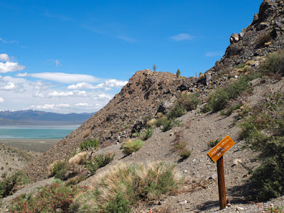
From Highway 120, about three miles northeast of the junction with Highway 395, a signed and passable dirt road led north to a parking area at Panum's base. It was empty except for the interpretive sign, whose explanation differed from what I had read, probably in the interest of simplification. Panum may be young, but already its life story is complicated.

North-facing sign, protected from damaging sunlight; note 6 stages at bottom.

Geologists have long found Panum interesting, starting with Israel C. Russell in the 1880s. Later, a pumice quarry on its south side revealed much of the local stratigraphy (layers of deposits), making it relatively easy to identify and sequence the various events. Also Panum is far enough away from other Mono volcanoes that its deposits are not mixed up with theirs. The verdict? Panum has experienced five distinct eruptions!

Because Panum has been so well-studied, Sieh & Bursik (1986) chose to describe and discuss its full evolution in their paper about the Mono Craters. Their treatment is thorough! Evidence included below is from that paper unless otherwise noted. But the story here is based on the very helpful USGS field guide to Panum, which nicely summarizes Sieh & Bursik's findings.

In Panum's first eruption, on a relic lakebed of ancient Lake Russell (Mono's ancestor), a tremendous blast of steam carrying lakebed sediments opened a vent and created a crater. Probably the rising magma heated groundwater to steam. Add gases released during decompression of the magma (like opening a bottle of champagne) and voilá—a phreatic eruption! Massive deposits of broken rock from the new vent ("throat-clearing breccia") and lake sediments have been found as far as a half mile from today's crater, attesting to the violence of that first eruption.

This was followed by a pyroclastic eruption, like the one that produced the Bishop tuff and Volcanic Tableland of my previous post. These are quite violent, very different from familiar creeping basalt lavas (e.g., Hawaii's). Instead, explosive eruptions send extremely hot (1500+º F) incandescent flows of ash, fragments and gas racing across the landscape, searing everything in their path. When they stop, they cool to form distinctive deposits called ignimbrites (L. fire rain!). Scattered deposits from this episode have been found all around today's Panum.

Volcanic Tableland (right) is the product of a recent immense pyroclastic eruption; Panum upper left (Google Earth 2019).

The third eruption probably produced a dome similar to today's. Degassing during the pyroclastic second eruption would have made the remaining magma so viscous that it could only be squeezed out of the vent (toothpaste is a common analogy). But it didn't last. Collapse of this dome explains deposits of large rock fragments north and west of Panum.

The Panum we know—both the crater and dome—was built during two recent eruptions. These were similar to earlier ones but probably less violent. We were able to experience some of this recent history via Panum's hiking trail.

Hiking the rim, with views of the dome (left) and crater below.
After a bit of an uphill slog through fragments of cooled magma, we reached the crest of the rim, about 200 feet above the plain below. It was created during Panum's fourth eruption, thought to be Strombolian. Hot ash and magma fragments were ejected in fiery arcs, landing to form the crater walls. Today's crater is about 0.4 x 0.25 miles across, and reaches a maximum depth (below the rim) of about 150 feet (measured on Google Earth).

Along the trail were occasional polished pebbles and gravel from the Sierra Nevada. Before Panum's birth, they had been deposited by Rush Creek where it entered Pleistocene Lake Russell. During the fourth eruption, they were gathered up by the rising magma, thrown into the air, and deposited along with volcanic fragments to form the rim.

Stream pebbles and magma fragments.
A Sierra Nevadan granitic pebble.
The outside crater wall is dry, the so-called soil loose. But plants grow there anyway, as best they can.

From the rim, we followed the trail down into the crater and then up to the summit of Panum's most recent creation—another dome. Once again, viscous degassed magma slowly oozed from the vent to create a silicic lava dome, i.e., greater than ~63% SiO2.
View from rim across crater below toward Panum's splintered dome.
Up out of the crater moat, headed for the dome summit; Mono Lake in distance.
At the summit we mingled with Panum's spires, enjoyed their shade, and admired the beauty of rapidly-cooled silicic lava.

Flow banding in the silicic lava of Panum's dome.
The cooled lava was a bit of a brain twister. Two forms were common—dull pale gray and glassy black. They often occurred together in striking banded patterns (above). Both were made from silicic lava. Both are volcanic glass, having cooled so rapidly that no crystals formed. And both are familiar: pumice and obsidian.

Pumice is known for being so light that it floats. It forms when gas in rising magma expands under decreasing pressure and creates bubbles. The resulting rock is filled with tiny air-filled holes, hence pumice's buoyancy.

Amazingly, gorgeously glassy deep black obsidian is made of the same stuff! It also cooled rapidly, but in this case there were no bubbles. Either the magma had remained pressurized while it cooled or somehow lost all its gas.

Obsidian among pumice fragments.
Obsidian, flow banding, and a bit of breadcrust lower right—such a great combo! 
Breadcrust—escaping gas expanded the hot interior of a flow, causing the cooled surface to crack.
Another of Panum's masterpieces.

What does the future hold for Panum? Sieh & Bursik concluded that its recent eruptions are indeed recent—dating from sometime between A.D. 1325 and 1365. They also noted that the fourth (Strombolian) eruption lasted no more than several months. Considering the amount and extent of deposits, that must have been an exciting time! Could it happen again?

Whether California's recent volcanoes are done or only dormant is a popular topic. Dormancy seems to be the more common conclusion. Sharp & Glazner note that Panum is "just a baby" and likely still developing. The much bigger domes to the south "must have looked something like [Panum] in their infancy."

Given our all-too-brief lives, it's possible that we've simply caught Panum between events. Or perhaps we're in the middle of one, as Israel Russell mused in 1889 (if only today's papers were so philosophical!). We may think we're looking at past volcanic activity but "... it is evident that we are comparing the events of a day with a whole volume of history. Could we look into the future with as much accuracy as we are able to review the past, it would be evident that changes are now in progress that in time will equal the apparent revolutions which occurred [earlier]".

Sources

Russell, I.C. 1889. The Quaternary history of Mono Valley, California, in USGS Annual Report 8:267–438. PDF

Sharp, RP, and Glazner, AF. 1997 (2003). Geology Underfoot in Death Valley and Owens Valley. Mountain Press Publ.

Sieh, K., and Bursik, M. 1986. Most recent eruption of the Mono Craters, eastern central California, J. Geophys. Res. 91(B12):12539–12571.

USGS. Long Valley Caldera Field Guide - Panum Crater


Monday, August 14, 2023

Volcanic Tableland & Owen's River Gorge

Last May on the way home from the West Coast, we stopped below the steep east face of the Sierra Nevada. From the campsite I looked out across the broad Volcanic Tableland, and saw a winding incision rimmed in rhyolite glowing in the evening light. It was the Owens River Gorge, the next day's destination where we would "experience" an ancient cataclysm. Geology is wonderful that way!
The Volcanic Tableland lies just north of Bishop, California. It's about 350 square miles in extent, and as much as 750 feet thick—a humongous block of rock called the Bishop tuff. It was named in 1938 by a geology grad student from the University of California Berkeley—Charles M. Gilbert. "Since the formation covers an extensive area, has characters unique in the region, and represents a definite part of the Pleistocene epoch, the name Bishop tuff is suggested as a fitting designation, after the chief town in the vicinity."
Gilbert's study area; town of Bishop added, location approximate.
Tuff forms from volcanic ejecta, mainly ash, blown out in explosive eruptions and then lithified (turned to rock) after deposition. Ash may stay airborne and travel great distances before forming fallout deposits. The alternative is much more deadly. The eruption column can collapse, sending hot incandescent ash flows racing across the landscape, searing everything in their path.

Gilbert spent three field seasons studying the Bishop tuff. He examined and sampled it at multiple depths in the Owens River Gorge, and across its extent from Bishop north to a few miles south of Mono Lake (in a tunnel being dug for the Los Angeles Aqueduct). Everywhere he went, he found the tuff to be rhyolitic (a common type, high in silica).

In fact the Bishop tuff was surprisingly uniform in composition, given its extent. However texture varied with depth—an important clue as to origin: "the tuff, soft and porous at the top, becomes gradually less porous and harder toward the base ..." Gilbert also noted that the soft uppermost tuff did not ring with the blow of a hammer, "in marked contrast" with hardened tuff below.

Back in the lab, microscopic examination of tuff samples revealed that ash and other fragments were welded together, increasingly so with depth. Gradation was continuous, and distortion had taken place without fracturing. Gilbert concluded the cause was "vertical com­pression by the weight of the deposit after its emplacement." And judging by the extensive welding, the deposit must have been extremely hot. There was but one possible perpetrator—a nuée ardente.
Nuée ardente or pyroclastic flow, Soufriere Hills, Montserrat; Nov 2010 (USGS).
"The nuées ardentes (burning or glowing clouds) remain, then, as the agent which probably emplaced the Bishop tuff. The nuées are flows of intensely hot, discrete fragments of viscous magma, in which each fragment rapidly and continuously emits its gases. The fragments are thus enveloped and cushioned by extremely dense, hot gas, and the whole has the appearance of a dense, rapidly expanding 'cloud'. Such a cloud rolls rapidly over even a gentle slope ... [leaving] hot pyroclastic material which may mantle the surface over an extensive area and which retains its heat and continues to emit hot gases for long periods of time. Only by some such agent can the em­placement and features of the Bishop tuff be explained." (Gilbert 1938, emphasis mine)

At the time of Gilbert's publication, the idea that welded tuffs were products of nuée ardentes was not widely accepted. In his Introduction, he explained that "the author hopes that the description of one of them given in this paper will help in the recognition of others which may be found and also contribute toward a better understanding of their origin." That hope has been realized! The Bishop tuff is world famous, a geological mecca of sorts.
For the rest of the story Gilbert resorted to informed speculation. Where was the volcano? Was there just one? The Bishop tuff's uniformity suggested a single source, but how could one eruption produce such a massive deposit? He thought it likely that multiple vents in near proximity were involved. "... the writer prefers to believe that the locus of vents lay in the vicinity of Long Valley since that valley has been a center of major volcanic eruptions since Pliocene time."

Today's geologists agree.
The Long Valley Caldera produced the Bishop tuff (orange). Inset shows ashfall deposits as far east as Nebraska and Kansas—1000+ miles. USGS (highlights added).
The Owens River flows from Lake Crowley (reservoir) in the former Long Valley Caldera and crosses the Volcanic Tableland via the Owens River Gorge. Google Earth 2019.
In the nearly 90 years since Gilbert's study, much has been learned about the Volcanic Tableland and Bishop tuff. They formed just 760,000 years ago (geologically young) during a series of eruptions in the area of today's Long Valley, as Gilbert suspected. It must have been spectacular!! In less than a week the vents disgorged 150 cubic miles of tuff—equal to the volume of Mt. Shasta and far more than any eruption in recorded history.

During this massive outpouring the ceiling of the magma chamber collapsed, creating an elliptical depression about 10 x 20 miles in extent—the Long Valley Caldera. Continuing eruption filled much of it, but not all.
The Volcanic Tableland is crossed by the Owens River Gorge—about 18 miles long, 200–800 feet deep, and generally less than 150 feet wide at the bottom. It provides terrific opportunities to examine the Bishop tuff, but also presents a geological puzzle: how did such a deep narrow gorge form?

For some 600,000 years post-eruption, water and sediment running off the Sierra Nevada ponded in the Long Valley Caldera. Then about 100,000 years ago, perhaps during a cool wet glacial interval, the lake breached the caldera rim on the southeast side and today's Owens River was born. What it did from there is unclear.
Lake Crowley in Long Valley; pale deposits upstream are from former Long Valley Lake. (Hildreth & Fierstein 2016, labels added).
Streamflow may have been vigorous enough to downcut rapidly through the relatively soft Bishop tuff (Sharp & Glazner 1993/2002). But meanders in the gorge suggest the Owens River was first a shallow winding stream. Perhaps with subsequent rising and tilting of the land (this area is tectonically active), the river downcut more rapidly but was constrained by established meanders (Hildreth & Fierstein 2016, 2017).

Whatever the scenario, the Owens River has incised a deep narrow gorge that exposes the innards of the Volcanic Tableland. Let's go have a look.
Owens River Gorge looking north; note meanders (Hildreth & Fierstein 2016).
The Gorge is accessible via roads and trails; directions are available online. It's very popular with rock climbers and anglers. But I was blessed with a parking spot close to the locked gate, on the road to the Los Angeles Dept. of Water & Power's Middle Gorge Power Plant.
Ways & Means (mine on right).
Pinkish-gray blobs are pumice fragments.
The rock at the parking area was extremely porous due to remains of tiny bubbles from the explosive eruption, and contained many randomly scattered fragments of pumice. It was surprisingly light, almost airy. With tuff in hand, I read the guidebook's horrific account of this place 760,000 years ago, when a searing racing cloud of molten magma fragments and volcanic gases exploded out of the Long Valley Caldera and came to rest here. Initially it was hot (1500º F!), plastic, and porous throughout. But that changed as the deposit cooled.

As we descended through the pyroclastic flow, the tuff became more dense, and pumice fragments more deformed. I matched rocks with guidebook descriptions while my field assistant waited in bits of shade. And I thought of CM Gilbert in whose footsteps we walked, wishing there were some way to tell him of the many geologists who pass this way every year, awestruck by the Bishop tuff.

Not far from the parking area, the tuff was denser but pumice fragments still obvious. There were irregular holes where fragments had fallen out. There also was a line of perfectly round holes—relics of paleomagnetic studies critical in developing plate tectonics theory in the 1960s.
Further down the road the tuff darkened, was denser (chunks were heavier), holes disappeared, and pumice fragments were blackish and much flattened.
Pink tuff with elongate blackish pumice fragments.
At a really obvious color change, we entered full-on welded tuff. It was uniformly dark gray and no pumice fragments were visible; they had been severely deformed and even remelted under that great burden of extremely hot volcanic debris. I lifted a chunk—it was much denser and heavier than the piece I hefted at the parking area.
My camera's meter struggles with dark rock in bright sun.
Then we turned around and walked back up the road.
Tuff recapitulation going up: dark gray to pink to almost white; welded and dense to porous and light.
Back at the top I looked across the Gorge and contemplated the spectacular columnar jointing, formed when the tuff shrank and cracked with cooling. The upper columns were slender and well-defined. Those below, which formed in slower-cooling densely-welded tuff, were larger and barely columnar, almost amorphous.
Here we have yet another puzzle. Usually columnar jointing is oriented perpendicular to the surface. But as Gilbert noted, "[in the Bishop tuff] columns may have any attitude whatever, from vertical to hori­zontal". He included a photo of a spectacular example.
Note curving columns center right; from Gilbert 1938.
I was thrilled when I realized that the photo in Gilbert's paper was taken very close to where I parked. In fact, it's a popular shot.
The Smithsonian's Global Volcanism website includes the same curved columns in the Bishop tuff.
My photo—a rock flower born of fire and water.
These odd arrangements of columns curving down to a common point have been called joint rosettes or rock tulips. They're attributed to fumaroles (vents through the tuff) that released volcanic gases enhanced with steam, perhaps where the pyroclastic flow overran and vaporized the ancestral Owens River. Indeed there are many fossil fumaroles on the Volcanic Tableland in the vicinity of the Gorge.
Bumps on the Volcanic Tableland are fossil fumaroles, typically 10–20 feet tall.
Atop a fossil fumarole. Tuff cemented with minerals from volcanic gases is more resistant to erosion.
Relaxing after a hot but fascinating day in the field.
Headings in this post use the Herculanum font, named after Herculaneum, a Roman city destroyed by pyroclastic flows from Mount Vesuvius.

Sources

Gilbert, CM. 1938. Welded tuff in eastern California: GSA Bull. 49:1829–1862.

Hay, RL. 1989? Memorial to Charles M. Gilbert, 1910-1988. GSA PDF

Hildreth, W, and Fierstein, J. 2016. Long Valley Caldera Lake and reincision of Owens River Gorge. USGS Sci. Inv. Rep. 2016–5120. https://doi.org/10.3133/sir20165120 

Hildreth, W, and Fierstein, J. 2017. Geologic field-trip guide to Long Valley Caldera, California. USGS Sci. Inv. Rep. 2017–5022–L. https://doi.org/10.3133/sir20175022L

Sharp, RP, and Glazner, AF. 1993 (2002). Geology Underfoot in Southern California. Mountain Press Publ.

USGS, California Volcano Observatory. Long Valley Caldera.

Monday, August 7, 2023

Treefollowing: last year's tree & a Carboniferous pond

Remember this tree? (August 2022)
Given how lovely it's been in the Laramie Mountains, I decided to check on the Balsam Poplar I followed last year instead of this year's junipers. Indeed it was a gorgeous day at Happy Jack, and warm enough, even at 8000 ft, that I chose the shady trail.

The old poplar was as I remembered—long past its prime yet still producing leaves. No matter that the canopy is less than magnificent, the trunk sprouting suckers. This is an impressive tree!
Canopy catching the sun.
Ancient trunk with vigorous suckers.
In keeping with tradition, we finished the hike with a visit to the Carboniferous Pond, named for its multitude of dragonflies.
Dragonflies are so abundant here that I accidentally nabbed one in this photo (arrow, click to view).
To get an actual dragonfly photo, I tried a new strategy—focusing the lens and waiting until one flew across my field of view. Results (or luck) seemed to improve with time. Dragonflies are quick and "spectacularly agile ... they can propel themselves upwards, downwards, backwards, forwards, side to side, and they can even hover in midair! This is due to the magnificent construction of their two sets of wings." (more here)
Dragonfly against reflections of sky, clouds, sedges—très artistique?
Got one,
... and another,
... and another,
... etc.
Finally a good one, with wings! (click to view)

This is my contribution to the monthly gathering of tree followers kindly hosted by The Squirrelbasket. Looking for a good time? Join us!