Monday, April 30, 2018

Cholla Fields of New Mexico

On my trip down the Dry Cimarron River, across the High Plains, and then on to the Cimarron proper, I often saw vegetation brand new to me but apparently common in New Mexico. From a distance I thought it was grassland with heavy shrub cover, maybe mesquite. But soon the distinctive form of the “shrubs” was obvious: thickish stems, awkward branching, no leaves. These were cacti.
Dry Cimarron valley, land of cacti and clastic plugs (mid photo).
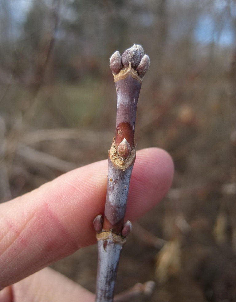
The cactus was unfamiliar, but easy to identify: Cylindropuntia imbricata, tree cholla. It’s large, three to seven feet tall, even 10 or 15 under favorable conditions. Often there’s a short “trunk” that soon branches. Spines are sparse, revealing green jointed stems. The yellow fruits stay on the plants through the off season. The most helpful features are the tubercles—bumps on the stems bearing specialized buds (areoles) that produce spines (more here). Cactus tubercles are usually described as “small rounded projections” but those of the tree cholla are large and elongate. The sparse spines make them easy to spot.
Yellow fruit from previous year still on plants in early May.
Stems are sometimes reddish in winter.
Prickly pear cactus (Opuntia polyacantha) has “small rounded” tubercles.
Distinctive elongate tubercles of the tree cholla.

Being a veg ecologist of the American West, I was suspicious of these cholla fields. Heavy shrub cover in grassland often indicates over-grazing. Livestock almost always prefer grass to shrubs, giving the shrubs a competitive advantage that can lead to dominance. How about tree chollas? Surely no cow or sheep would eat one if grass were available.
Grassland thick with tree chollas, Dry Cimarron Valley (with ghosts of travelers past).
Tree cholla grassland on the High Plains north of Clayton.
Tree chollas, just west of Cimarron.
Back at home, I looked for tree cholla vegetation types in the US National Vegetation Classification. I found a good match: Opuntia imbricata Ruderal Shrubland (Opuntia is a synonym for Cylindropuntia). My suspicions were confirmed:
“This anthropogenic (semi-natural) shrubland results from overgrazing of native grasslands. It occurs particularly in slightly moister settings along broad swales. Infestation of Opuntia imbricata [synonym for Cylindropuntia imbricata] is variable, and cover of Opuntia in this type ranges from 25% to nearly 100%. Grass cover and composition is highly variable, depending on site and grazing regime and history. This broadly defined community grades to grassland (often with some Opuntia cover) or to other grazing-induced shrubland communities, such as those dominated by Prosopis, Acacia, and/or Mimosa [shrubs in the pea family] (NatureServe Explorer).
Now the inevitable counter-questions: What about bison (buffalo)? There was a time not all that long ago when bison numbering in the millions roamed the American West, including New Mexico. What did these grasslands look like then? How common was tree cholla? Did bison eat it as readily as grass? The answer: we don’t know and probably never will (add these to life’s persistent questions).

But these questions are irrelevant where tree cholla has been introduced. It’s now widely naturalized—in eastern and southern Europe, northern and southern Africa, southern South America, and eastern Australia, often to the detriment of grasslands. For example, in Queensland, it threatens native semi-arid grasslands, and has been listed as a priority environmental weed (source).

Ironically, while land managers try to find a way to eradicate tree cholla (e.g., fire, chaining, chemicals), gardeners are encouraging it. “C. imbricata is one of the best chollas for desert landscaping. … It is an attractive plant in desert gardens, and cultivation is quite easy” [for the same reason it’s so hard to eradicate in pastures]. “All you have to do is plant one of the ten-twelve-inch stems in the ground. Water it after it has a chance to put out roots, in a few weeks.” Saguaroland Bulletin v.30:no.1-10 (1976)
Summer flowers (NPS).
Tree cholla is not restricted to desert gardens. It has long been grown in Europe, though not without challenges:
“It is the commonest member of the group to which it belongs in European gardens, and was first introduced to cultivation in the earlier years of the nineteenth century. In spite of this, however, it is a plant whose flowers, which are very attractive but which will only expand under the influence of direct sunshine and unfortunately do not last long, are not often seen in the United Kingdom. Sir Edmund Loder informs us that his example at Leonardslee has but seldom flowered; when it did so in 1908 this happened during a time of very hot, sunny weather, and individual flowers only remained fully open during one afternoon, from about midday till sunset.” Curtis’s Botanical Magazine v. 135; 1909
Curtis's Botanical Magazine, 1909 (courtesy Biodiversity Heritage Library).


Friday, April 20, 2018

In Search of Iridium & the Smoking Gun

Is this the smoking gun?
Or this? (Western Ghats, Deccan Large Igneous Province; source)
Probably you’ve heard about the meteorite that killed off the dinosaurs, but just in case you haven't … it hit the Earth (Yucatan Peninsula) 65 million years ago, sending massive amounts of debris into the atmosphere. Major climate change ensued, so quickly and dramatically that many species (not just dinosaurs) were driven to extinction. The ejected debris included iridium from the meteorite itself—the “DNA” that “solved” the crime. It rained down on Earth forming a thin layer now exposed at sites around the world—the iridium layer or anomaly. What a terrific story! So much of drama!! And it solves what used to be a hugely challenging and vexing puzzle.

Or maybe not. When I visited the iridium site at Raton, New Mexico, I already knew the story wasn’t so simple; probably many readers do as well. But the meteorite-as-dino-killer story lives on, understandably. The mind-boggling horror is irresistible: “NIGHT OF THE DINOSAURS … the end of the Dinosaur Age on planet Earth”!!!
“Iridium Layer marks End of Dinosaur Age on Planet Earth” is not a B-movie title; it’s the lead on a faded interpretive sign.
However, it's possible that the smoking gun is not the famous iridium layer (1) but rather extensive thick basalt flows in west-central India—the Deccan Large Igneous Province (Deccan Traps). Covering more than 500,000 sq km, it’s one of the largest LIPs in the world (Mukherjee et al. 2016). Like the Yucatan meteorite crash, these eruptions took place about 65 million years ago, roughly concurrent with dinosaur extinction. Volcanism on that scale likely ejected enough material (and possibly iridium) to cause significant climate change, perhaps leading to dino demise. Even more intriguing, the Yucatan meteorite impact may have caused the massive volcanism (see Sources below for more details).

There also are complicating factors regarding the scale and timing of extinctions. For example, some dinosaurs already were in decline, some survived (the birds), and not all life forms were affected. Maybe climate-changing meteorite-caused massive volcanism exacerbated challenges already faced by species in decline. Or maybe there’s another surprising puzzle piece waiting to be discovered! In any case, the iridium layer is worth a visit … nothing wrong with a little mystery in the drama.
“What minor evils might arise from the contact [impact] were points of elaborate question. The learned spoke of slight geological disturbances; of probable alterations in climate, and consequently in vegetation …” Edgar Allen Poe, 1839 (2)
The iridium site at Raton, New Mexico is just north of town, a short distance up a winding paved and gravel road passable to cars. In addition to the famous anomaly, there’s a picnic table and great views.
Town of Raton below Raton Mesa—note basalt cap on horizon.
The iridium layer is exposed on a short steep bank next to the IRIDIUM LAYER sign. I say “exposed” rather than “visible” because I wasn’t sure I found the actual layer. Neither of my guidebooks offered specific guidance. The interpretive sign was much more helpful, though some words were illegible:
… a thin clay-like layer—just above the level of the IRIDIUM LAYER sign … 8 inches beneath the coal layer … weathers to a fine white powder. This layer consists of melted rock (glass since altered to clay) blown out of the impact crater (asteroid). High concentration of iridium and shocked minerals … suggesting “not of this planet” (3)
According to the interpretive sign, the iridium anomaly lies in the narrow layer between the grayer rocks from late Cretaceous times, the “final period of the dinosaurs,” and the early Tertiary tan rocks above, from the “Era of Mammals” (the early part of the Tertiary is now called Paleogene). Is that a minor fault offsetting the layer mid photo?

Back at home, I searched Google images for help. Sure enough, I’m not the only one who has had trouble finding the iridium layer. One amateur geologist who visited the well-known site near Trinidad, Colorado (about 20 miles from Raton) went so far as to have backscatter scanning electron microscopy (BSEM) and chemical analyses done on what he thought was clay from the iridium layer, only to learn there was no iridium. As he explained, the distinctive clay layer (kaolinite) he sampled marks the Cretaceous-Tertiary (Paleogene) boundary, but “the iridium I’ve since learned isn’t actually concentrated in the clay layer itself but in the 2 layers directly above it (red arrows in photo): that is the impact layer (smectite - blue arrow in photo), and the 2-inch coal layer directly above that.

He also noted that kaolinite “is thought to result from the altering of volcanic ash beds in acidic coal swamps, but in this case it’s the result of a doomsday shroud of impact material interacting with a coal swamp.” But do we know? Maybe it’s altered volcanic ash after all.
Source (used for personal, educational purposes).
“I was at the right place and was able to identify the boundary layer, I just didn’t have all the facts. But at least I’ve learned something from my mistake, so it turns out not to be such a bad thing. And now you’ve learned something, too.” anonymous amateur geologist on scienceBuzz

Notes

(1) Whatever the cause, the K/T boundary at the Raton site marks environmental change, for it's defined by the disappearance of Proteacidites pollen. At Sugarite State Park nearby, a spike of fern spores occurs just above this boundary, and has been interpreted as “opportunistic fern species replacing the normal plant community that was devastated by the extinction event.” (Paul Bauer, p 262 in Price 2010)

(2) Poe was referring to a comet that destroyed life on Earth, as described by one of the dead. See The Conversation of Eiros and Charmion.

(3) Actually, iridium is of this planet, especially “in molten rock deep within.” High concentrations of iridium could be evidence of large-scale volcanism (source).

Sources

Cowen, R. No date. The K-T extinction. UC Berkeley. http://www.ucmp.berkeley.edu/education/events/cowen1b.html

Muehlberger, WR, Muehlberger, SJ, and Price, LG. 2005. High Plains of northeastern New Mexico, a guide to geology and culture. NM Bureau of Geology and Mineral Resources.

Mukherjee, S, et al. 2016. Tectonics of the Deccan large igneous province: an introduction. Geological Society, London, Special Publications 445: 1-9. http://sp.lyellcollection.org/content/445/1/1

PBS.org. No date. What killed the dinosaurs? http://www.pbs.org/wgbh/evolution/extinction/dinosaurs/volcanism.html

Price, LG (ed). 2010. The geology of northern New Mexico’s parks, monuments, and public lands. Socorro: New Mexico Bureau of Geology and Mineral Resources.

Sanders, R. 2015. Did dinosaur-killing asteroid trigger largest lava flows on Earth? Berkeley News. http://news.berkeley.edu/2015/04/30/did-dinosaur-killing-asteroid-trigger-largest-lava-flows-on-earth/


Friday, April 13, 2018

Hints of Spring while the Boxelder Waits

Boxelder on left. Did I mention that the Territorial Prison is just across the river? (far right, click image to view)

It must be spring—the construction crews are back, working on the new street nearby (featured here). A few weeks ago they took away the amazing Gomaco curb-and-gutter machine, and brought in truckloads of dirt. Landscaping and sound barriers are on the agenda. The street and bridge are due to open this summer—at last we will have a safe convenient bicycle/pedestrian path across the railroad tracks :-)
But as far as I can tell, the boxelder I’m following hasn’t changed at all since last month, though there’s now snow at the base. About three weeks ago we finally had a blizzard. It dumped almost a foot of wet snow, followed by several smaller storms—enough that patches remain in the boxelder’s shady nook. After such a dry winter, it was a blessing.
While the boxelder waits, other plants are starting their growing seasons. Grasses are greening up, and the Easter daisies in my wildflower beds are beginning to open.
Easter daisies, Townsendia hookeri; coin is just under 1 in across (2.5 cm).
Our local spring parsley is blooming too, a small inconspicuous plant generally overlooked. For some reason it was named Cymopterus montanus even though it’s a prairie plant, so the powers that be have declared the official common name to be mountain spring parsley. Every year I resolve to photograph it but have failed until now, even though it grows just outside my fence, and being prostrate, is not disturbed by “spring breezes” (when I shot this photo, the wind was blowing 35 mph with gusts to 48).
Spring parsley has clusters of tiny flowers, surrounded by papery bracts.

If you were hoping for a boxelder fix, don’t despair. I’ve included photos from TreeLib. Don’t know TreeLib? It’s great. Blake and Nathan Wilson (father and son) provide descriptions and high-quality photos of 380+ tree species, free for non-commercial use. Blake is a dendrologist and photographer, Nathan a web designer. They’ve put together an elegant easy-to-use site.
“Trees are our silent partners, sensing us as we move about, providing shelter, offering us beauty, and nurturing and protecting the earth.” (TreeLib home page)
The Wilsons are Canadian, so Manitoba maple is the first common name listed for the tree we in the US call boxelder. But no problem—searching is based on scientific name, in this case, Acer negundosame genus as maples (because it is a maple! … more below). It’s also possible to browse TreeLib by common name.
Manitoba maple in British Columbia. Hard to imagine my scruffy boxelder looking like this!
Boxelder leaves are compound, with 3-7 leaflets. You can arrange them to show that boxelder is indeed a maple (one of Mike’s ranger tricks).
Convinced? (works better in real life)
Pendulous clusters of tiny male flowers.
Samaras—paired winged fruit, also known as keys.
Buds just like the ones I check each month, hoping for action.
TreeLib says boxelder “is one of the most widespread and adaptable of all North American trees” (emphasis added). I can believe it!

For more tree-following news, check out the April gathering kindly hosted by The Squirrelbasket. All are welcome join us! … more information here.


Friday, April 6, 2018

Tilted Rocks & the Abyss of Time

“I rejoiced at my good fortune in stumbling upon an object so interesting to the natural history of the earth …” James Hutton, 1788
Me too, James!

On a cool sunny day, almost a year ago now, I drove down the valley of the Dry Cimarron River in northeast New Mexico. On either side were rock walls—brown, red, yellow and almost white sandstones and mudstones, earthy and rich against the bright sky. They were neatly stacked in horizontal layers—not so different from several hundred million years ago, when they were still beds of sediment.

But then I came upon Steamboat Butte (1), with its rocks askew! Here was an example of the “object” that had brought such great joy to James Hutton 230 years ago—an angular unconformity. Underneath a cap of horizontal sandstone were tilted redbeds.
Whenever I see an angular unconformity I also see, in my imagination, a hand-waving geologist expounding on its creation, interpreting the story told by the rocks. But on that day, all I had was a rather laconic guidebook, which intoned: “The underlying Triassic Travesser Formation was tilted and eroded before the overlying Jurassic Entrada Sandstone was deposited.” I had hoped for more—I wanted to “rejoice” and “grow giddy” looking into the deep abyss of time! So when I returned home, I consulted with two men famous for profound geological insights that stemmed in part from their study of angular unconformities—Nicholas Steno and James Hutton.

Nicholas Steno—anatomist, pioneering geologist, bishop, saint (Wellcome Collection).
Nicholas Steno worked in the Tuscan part of the Apennine Mountains in the mid 1600s, initially studying fossils. He was barely a geologist, but that was only because in his day geology was still in its infancy. Steno came up with some of our most basic geological principles, which he published in 1679 in his Prodromus. It was to be a brief introduction to a lengthy dissertation on geology, paleontology and more, but he never wrote it (2). Still, there was enough in the Prodromus to start a revolution in thinking about Earth history.

At that time, it was widely believed that when God made the Earth, it was pretty much as it is now. The land has been eroded, that can be seen. But erosion is far too slow to have much impact. Steno concluded otherwise—that the Earth had changed significantly, and would continue to do so, as God intended. He had found convincing evidence, most famously seashells on mountaintops.

Steno also saw evidence of change in tilted sedimentary rocks, which began as sediments deposited in water, i.e., as horizontal beds (his principle of original horizontality). Given that they’re now "at an angle to the horizon", something must have happened. But what? Steno attributed tilting to collapse of rock layers into a large cavity. He described this interpretation in the Prodromus, with cross-sections and a brief summary. “Here I shall only reckon up in short the order of the change” (for details, readers were referred to the promised dissertation).

Steno's description proceeds from past to present. Figure 25 shows a seafloor with “beds yet entire, & parallel to the horizon.” In 24, a vast cavity has been “eaten out by the force of Fire and Water, without any breach in the upper Beds.” Eventually the upper Beds collapse (23), creating a valley with tilted rocks on either side.
In the valley, now filled with seawater, “new Beds” form (22). Fire and water again eat out a cavity (21), and the upper Beds collapse (20). But this time, the breach reveals old tilted beds below the horizontal new Beds—an angular unconformity!
Broadly-speaking, Steno’s explanation is similar in many ways to today’s thinking, and was remarkable given the paucity of geological knowledge then. Collapse of large cavities is no longer accepted, yet modern thinking does incorporate collapse of rock beds in some cases, though not as a separate step. Rocks are too weak to form superior beds over a huge cavity; instead, they collapse as land is being downwarped (Alvarez 2009).
Steno would say the redbeds collapsed into a cavity before the red-and-white sandstone above was formed.

James Hutton—chemist, gentleman farmer, pioneering geologist (1776, source).
In 1787, James Hutton was walking along the Jed Water in the Scottish Borders, his eyes glued to the rocks. At Inchbonny, he was stopped in his tracks:
“I was surprised with the appearance of vertical strata in the bed of the river, where I was certain that the banks were composed of horizontal strata [italics added]. I was soon satisfied with regard to this phenomenon, and rejoiced at my good fortune in stumbling upon an object so interesting to the natural history of the earth, and which I had been long looking for in vain. … Here the vertical strata, similar to those that are in the bed of the Tweed, appear; and above those vertical strata, are placed the horizontal beds, which extend along the whole country.”
Hutton had found an angular unconformity! (he called it a junction). His friend John Clerk made a drawing, which appeared in Hutton’s Theory of the Earth (1788).
Hutton’s Unconformity at Inchbonny, drawn by John Clerk (source).
After studying multiple exposures of the junction, Hutton came up with an explanation. The vertical beds, which he called the schistus, were marine sediments turned to rock, due to pressure and heat. The seafloor was heaved up to form land, tilting the beds, which were “laid bare” (eroded) into a roughly flat surface. Then the land subsided, and another cycle began (3). Now the sand-stone was deposited, and again the seafloor was heaved up and laid bare. But this time, erosion revealed the schistus/sand-stone junction (4).

However, there was a major problem with this story. The processes Hutton invoked—deposition, uplift, erosion—were much too slow. To complete the two cycles needed to create and reveal the junction would require an immense amount time, far more than the 4000-6000 years said to be the age of the Earth. But Hutton was not one to be constrained by dogma. He concluded that the Earth was far older than people thought; the schistus–sand-stone junction (now called the Hutton Unconformity) was proof. It was Hutton who introduced the concept deep time, critical to geology. With deep time, even a very slow process can produce major change.
Hutton’s Unconformity at Siccar Point; gently tilted sand-stone above near vertical schistus (source).

Two centuries have passed since Hutton described the junction he found in the Scottish Borders. Yet his interpretation of angular unconformities is very much the same as today’s: the lower rocks were tilted, and then buried in sediments that would become the upper rocks … as in the case of Steamboat Butte.

Like the schistus, the Travesser redbeds began as sediments, though in a lake most likely. The resulting rocks were tilted when the region was uplifted (5), and were sheared off (“laid bare”) by erosion. Sediments accumulated atop the redbeds—in this case, massive amounts of sand deposited by wind to form a giant erg (sand sea). The erg became the Entrada sandstone; a remnant now caps Steamboat Butte. We can see this unconformity because the Dry Cimarron River has cut down far enough to reveal it.
The angular unconformity at Steamboat Butte is far younger than Hutton’s, but it still provides the thrill and joy of peering into deep time. In fact, to describe the experience we would need to modify only slightly the words of John Playfair—Hutton's friend who accompanied him to Siccar Point:
“We felt necessarily carried back to a time when the redbeds on which we stood were as yet the surface of the land, and when the sandstone before us was only beginning to be deposited in the shape of sand dunes, fashioned by the wind ... The mind seemed to grow giddy by looking so far back into the abyss of time!”
Stop and read the rocks—so much to learn, such joy to be had!

Notes

(1) Steamboat Butte is sometimes called Battleship Mountain.

(2) Shortly after the Prodromus was published, Steno abandoned geology, devoting the rest of his life to the Catholic Church. He died in 1686, and was beatified in 1988.

(3) Hutton considered the Earth to be in a steady state maintained by elevation and erosion—a series of cycles with “no vestige of a beginning – no prospect of an end”.

(4) Hutton’s “schistus” is now known to be Silurian sandstones and shales (433 Ma). The “sand-stone” is today’s Devonian Old Red Sandstone (370 Ma) (Prothero 2018).

(5) The timing of Travesser redbeds tilting is unclear; apparently it wasn't associated with mountain-building. The Ancestral Rocky Mountains (circa 300 Ma) predate the redbeds, and today’s Rockies (Laramide Orogeny, circa 70-50 Ma) are younger than the sandstone. Muehlberger et al. (2005) refer only to a “pre-Entrada fold”. Parker (1933) reported numerous such folds in the Dry Cimarron area.


Sources

Alvarez, W. 2009. The Mountains of Saint Francis; discovering the geologic events that shaped our earth.

Baldwin, B., and Muehlberger, W.R. 1959. Geologic studies of Union County, New Mexico. New Mexico Bureau of Mines & Mineral Resources Bulletin 63.

Cutler, A. 2003. The Seashell on the Mountaintop. A biography of Steno emphasizing his pioneering contributions to geology and paleontology.

Hutton, J. 1788. Theory of the Earth. Transactions of the Royal Society of Edinburgh, 1.

Muehlberger, WR, Muehlberger, SJ, and Price, LG. 2005. High Plains of northeastern New Mexico, a guide to geology and culture. NM Bureau of Geology and Mineral Resources.

Open University provides a clear interesting account of Hutton’s geology.

Parker, BH. 1933. Clastic plugs and dikes of the Cimarron Valley area of Union County, New Mexico. Journal of Geology 41: 38-51.

Prothero, DR. 2018. The story of the Earth in 25 rocks. Columbia University Press.

Steno, N. 1671. The Prodromus to a dissertation concerning solids naturally contained within solids. Laying a foundation for the rendering a rational account both of the frame and the several changes of the masse of the Earth, as also of the various productions in the same. English translation