Thursday, August 31, 2017

Succumbing to the Siren’s Song (eclipse-viewing in Wyoming)

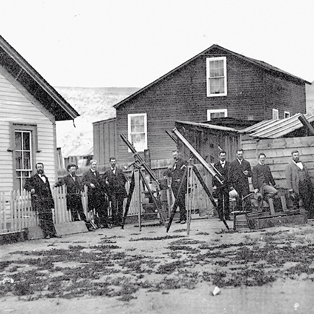
Eclipse station at Rawlins, 1878 (The Daily Graphic, New York).

Sometimes the stars align just right, or—as in this case—a star and two orbiting bodies. When the Moon lies in the same plane as the Earth’s orbit around the Sun, and is close to Earth (at perigee), those in the right place are blessed with a total solar eclipse. This year we were among the chosen, but it was not the first time. In fact, the excitement of July 1878 still looms large in the short history of our state.

That year, a total solar eclipse traveled north to south over the western part of Wyoming Territory. Fortunately the First Transcontinental Railroad had been completed just nine years earlier. The path of totality crossed the railroad in the weather-beaten little town of Rawlins, and it was there that some of the world’s greatest astronomers gathered to observe things normally hidden by the Sun’s blinding light. They were joined by several lay assistants, including the Territorial governor.

Famous inventor Thomas Alva Edison chose Rawlins over Denver to measure the temperature of the corona with his tasimeter. Reporters were there to telegraph the news to the outside world. Soldiers came from Fort Steele to build observatories and other temporary structures. The town’s population ballooned, from 600 to maybe 700 or more. Accommodations were filled to overflowing, and some visitors slept in tents or railroad cars—or wherever they could.
Path of eclipse, 1878; Rawlins (misspelled) underlined in red (New York Weekly Tribune).

On August 21, 2017, the Moon’s shadow again passed over Wyoming. This time the path of totality extended 400 miles from west to east, across the center of the state. Hordes of pilgrims came in search of a cosmic experience, the majority driving up from Colorado that day. The population of Wyoming is said to have doubled, reaching one million (1).

We knew they were coming, and for months we analyzed and debated the best places to go. I opted for the Empty Quadrilateral in the center of the state (2).
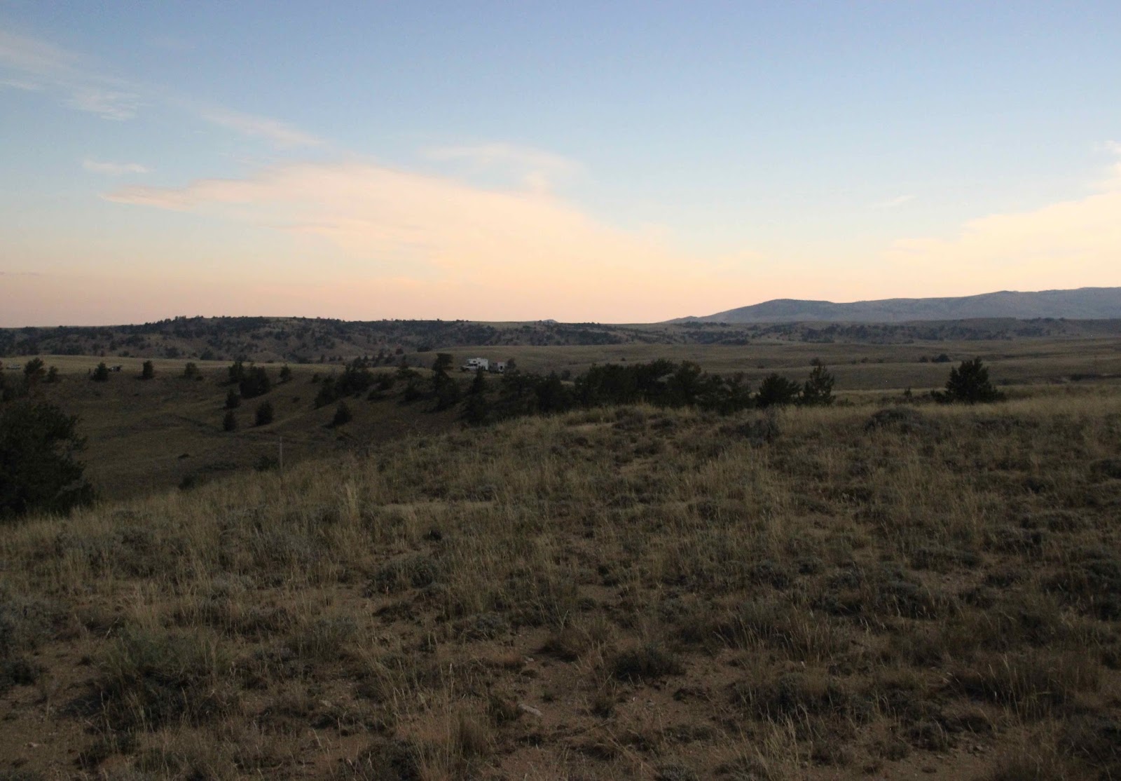
I left Laramie mid-morning, and five hours later found what I was seeking. It was a very Wyoming kind of place—not the rugged mountain peaks that dominate tourist literature but high desert, on the northeast end of Beaver Rim where it meets the Rattlesnake Hills. Sagebrush and grass covered the broad divide, with limber pines scattered along the escarpment below. The view to the west stretched far across the Wind River Basin, into a distant haze of forest-fire smoke.

At first I was sorry that my Colorado friends had canceled, but by nightfall four other parties had distributed themselves along the Rim—new friends. We chatted about the day to come, full of excitement but also anxious. Would the sky be clear? (forecast was “mostly sunny”)
Pilgrims camped on Beaver Rim, awaiting the total eclipse of the Sun.
Monday dawned partly cloudy, the sky half-covered in high wispy clouds. They evaporated after a few hours, to our relief. The day warmed. Soon it was hot, yet we stood in the full Sun—staring at it. Our certified glasses revealed an imperfect orange ball, with a growing black chunk obscured by the Moon. Sun flecks cast by the colander shrank to crescents, looking like cartoon-character eyeballs. But we wouldn’t have noticed anything unusual without this special gear. The Sun shone brightly; the day got hotter.
Modeling the latest in eclipse fashion.
Vintage family colander as multiple-pin-hole camera.
Then around 11:25, things started to get weird. The temperature dropped markedly, and the world darkened, taking on a lurid cast just as Canadian-American astronomer Simon Newcomb had said. “The light seemed no longer to be that of the sun, but rather to partake of the character of an artificial illumination.” I heard the words of Scottish Astronomer Royal Piazzi Smith: “Its effects on the minds of men are so overpowering, that they forget their appointed tasks of observation.” Did I really hear that?! I was too excited to care.
The darkening day.
The Moon’s shadow was approaching and approaching fast. Suddenly—in an instant—daylight was gone. But this was not the dark of night; I could make out my dog, my neighbors, and my car with limber pines behind. Overhead, the Sun had been replaced with a jet black disc, surrounded by a thin brilliant ring of light and pale diaphanous streamers.

That’s when the shouting started—not eclipse-crowd cheering, but rather a disembodied voice accompanied by banging, somewhere off to the south.
bang, bang, bang, bang … TEN!! bang, bang, bang, bang … TWENTY!!
I ignored it. After all, everything was weird. For example, the Moon's shadow had raced in from the west, instead of from the east where the Moon normally appears, rising slowly. I tried to visualize the various celestial bodies moving, while we tiny observers watched from our limited vantage points.
bang, bang, bang, bang … FORTY!! bang, bang, bang, bang … FIFTY!!
I realized I was wasting precious time. The Moon’s shadow was immense, but it was traveling at 1000, 1500, maybe even 2400 miles per hour! (accounts varied) The wonders of totality would be over in less than two minutes.

I grabbed my binoculars and noticed that the lower right section of the brilliant ring was red—maybe solar prominences, plasma from the Sun’s surface. And in spite of advice not to try to photograph the eclipse itself, I made a quick shot of the black haloed Moon.
Grainy, over-exposed, with lens flare … but full of memories.

bang, bang, bang, bang … EIGHTY!! bang, bang, bang, bang … NINETY!!
The eerie ruckus continued. I wished it would stop! … until I realized what it was. Captain William H. Beebe from Fort Steele was serving as totality timekeeper, counting the passing seconds. Out on Separation Flats west of Rawlins, the wind blew so hard that he had to bang on a cast iron lid from the cookstove to be heard. He shouted every tenth second.

I thought I could make out other voices—maybe that was Edison shrieking in ecstasy that his tasimeter was finally working (the wind died down). Someone cried over and over … turn your glass, turn it to to the southwest! Vulcan, Vulcan!! (probably Watson the planet-hunter). Then bang, bang, bang, bang … ONE HUNDRED!!

While Captain Beebe counted and the prominent astronomers went about their tasks, I just stood there, staring at a conjoined Sun and Moon. I completely ignored the Astronomer Royal’s stern admonition: “a total eclipse is a potent Siren’s song, which no human mind can withstand, for its effects on the minds of men are so overpowering …” He was unable to finish, for just then, the diamond signaling the end of totality flashed with tremendous brilliance. It ended as suddenly as it had begun. The Moon’s shadow raced toward Nebraska. The ghostly voices to the south were silent (3).

Over and over I replayed totality in my mind, cementing details firmly in memory. But the experience was impossible to save—it was gone.
“The totality had passed away like a dream, and no earthly power could recall that shaded sun.” (astronomer Cleveland Abbe, Dakota Territory, 1869)
As the Sun reappeared, the colander projected little smiles.

Footnotes

(1) One million is frequently cited, but is not an “official” tally.

(2) “Empty Quadrilateral” is my name for the part of Wyoming bounded roughly by Highways 287, 220, 20/26, and the Lander–Riverton “metropolitan” area. I left home with no specific destination, as previously I’d only explored the margins.

(3) The eclipse expeditions of 1878 showed the world that the young United States deserved respect for its science and technology. For a full and fascinating account, read American Eclipse by David Baron (2017). Highly-recommended.


Thursday, August 24, 2017

Why we’re here (geology is destiny)

Laramie, Wyoming (Territory) circa 1868: Union Pacific Railroad machine shops (USGS).
[In 1881, an unhappy Bill Nye quit his job with the Laramie Daily Sentinel—the first and only paper in town—and started a competitor, naming it the Laramie Boomerang after his mule, who “always came back.” Sure enough, while the Sentinel folded in 1895, the Boomerang still shows up daily. One of its more popular features is the monthly column, Laramie’s Living History. I’ve contributed several articles, about the role of botany and geology in local history. Here’s the most recent (with a few additional photos).]

[August 12, 2017]

Anyone who has lived in Laramie long knows why we’re here: 150 years ago, the Union Pacific (UP) passed through the Laramie Valley (southeast Wyoming) during construction of the nation’s first transcontinental railroad. But that’s only part of the story. The full explanation begins much earlier, back when a fortuitous combination of mountain-building and erosion created an easy route over the Laramie Mountains—the Gangplank.

One hundred million years ago, much of Wyoming was underwater, covered by the Western Interior Seaway, which split the continent from north to south. But it was not to last. Thirty million years later the land began to rise, forcing the sea to retreat. This was when the Laramie Mountains were born, part of a long and widespread episode of mountain-building that created most of the Rockies.

For the next 10-15 million years the Laramie Mountains rose, while at the same time erosion wore them down. Such is the fate of mountains—as soon as uplift starts, erosion sets in. As much as 20,000 feet of material is thought to have been removed from the crest of the range. Streams and wind carried down the debris, depositing it on the flanks and eventually burying the Laramie Mountains in their own rubble.

It’s hard to imagine such huge changes: a sea disappearing, mountains rising, mountains worn down and buried.  But at the scale of geologic time, the Earth’s surface is dynamic, always changing. This we know, though we can’t always explain why. Many mysteries remain … for example, today’s Laramie Mountains.

Ten million years ago, when the range was mostly buried beneath a thick covering of sedimentary rocks, the east flank was a broad gently-sloping plain. That’s not the case today (think Sybille Canyon!); obviously something happened. We know that erosion resumed, but why? Perhaps the entire region was uplifted, invigorating streams. Maybe climate change brought greater precipitation. Whatever the reason, the sedimentary cover was removed during what geologists call the Great Exhumation. The Laramie Mountains were disinterred … almost.

Due to a serendipitous evolution of topography, the Great Exhumation left intact a gently-sloping wedge of sedimentary rocks in the southeast part of the range. Several million years later, on September 21, 1865, General Grenville M. Dodge, soon-to-be chief engineer of the UP, scrambled up the ridge south of Crow Creek and found himself on this wedge. He was ecstatic. Here was an easy route up the Laramie Mountains, later christened “the Gangplank.”
Looking east along the Gangplank, traversed by I-80 and the UP Railroad; added star marks contact of ancient granite in foreground and much younger sedimentary rocks behind. RD Miller photo (USGS).
Just two years after Dodge’s lucky find, on the evening of October 21, 1867, UP tracklayers entered today’s Wyoming. They barely paused at Cheyenne, pushed west up the Gangplank, wound down into the Laramie Valley, and in early May of 1868, reached Laramie City, where eager new residents had been throwing up buildings the week before. Then the tracklayers raced west, laying another 350 miles of track and establishing numerous “instant towns” before leaving Wyoming in early 1869.
Union Pacific Railroad (1905); added arrow points to the Laramie Mountains (American Heritage Center).
The Gangplank is most striking at its western tip where the younger sedimentary rocks meet the ancient Sherman Granite. Only a few hundred feet separate the drainages of Crow and Lone Tree Creeks, and, though imperceptible to us, these streams are hard at work. Every year they erode a bit more rock and soil, sending it down to the North Platte River, the Missouri, and eventually the Gulf of Mexico. In other words, the Gangplank won’t be here forever. You might want to take a look at it while you still can!


From Laramie, follow Interstate 80 east to the Summit and the Sherman Granite, which forms the crest of the range. This is ancient rock—formed from magma 1.7 billion years ago. It was exposed much later during uplift of the Laramie Mountains. I-80 stays on Sherman Granite past Blair, Vedauwoo, Tree-in-the-Rock, and Buford. Here the terrain is relatively flat, and it’s tempting to think this is the Gangplank. But road cuts and occasional blobs of granite show otherwise.

Continue past Remount Road (Exit 339) and Harriman Road (Exit 342, large quarry). Just a short distance further, before the Wyoming Department of Transportation sand/salt storage structure, is the transition to the Gangplank. But don’t slow down!! I-80 traffic is too heavy and fast for gawking. Instead, continue about three miles to Exit 345; drive to the truck parking area on the Gangplank.

At the east end of the parking area is a sign illustrating the Gangplank rising from the Great Plains onto the Laramie Mountains. The text makes more sense when you realize the sign originally stood at the west end of the Gangplank (you’ll be there soon). The slope next to the parking area reveals some of the sedimentary rocks that covered the range ten million years ago, before the Great Exhumation.
Block diagram inspired by SH “Doc” Knight, Mr. Geology of Wyoming; from sign at truck parking area.
Rocks exposed on slope are part of the Tertiary Ogallala Group.
After mastering the diagram on the sign, find the westbound frontage road at the opposite end of the parking area. Set your trip meter to zero and drive the Gangplank. At 2.0 miles, just past Mile Marker 2 (green) and near the top of the hill, you will leave the ten-million-year-old sedimentary rocks and return to the ancient Sherman Granite. Here, at the tip of the Gangplank, you can straddle more than a billion years of Earth history.

From the hilltop, the view east toward Cheyenne gives a good feel for how narrow this end of the Gangplank is. The north side (left) drops steeply down to the South Fork of Crow Creek. Lone Tree Creek is off to the south (not visible here). In the distance, the Gangplank widens and merges with the Great Plains in Nebraska.
Looking east from the west end of the Gangplank; South Fork Crow Creek on left.
More points of interest on the Gangplank, and additional driving tours of railroads past and present, are included in Railroads of Albany County—Tracking the Past. This free brochure is available at the Laramie Area Visitor Center and the Historic Railroad Depot. A scanned version is available online: http://www.laramiedepot.org/about/railroadsofalbanycounty/tabid/76/default.aspx


Editor’s Note:  This is one in a series written for the Albany County Museum Coalition that promotes interest in local cultural and natural history.  Hollis Marriott came to Wyoming in 1977 to work at Devils Tower National Monument, fell in love with the wildness of the state, and stayed. She received a master’s degree in botany from UW in 1985. Now retired, she indulges her passions for botany, geology, and the great outdoors in general.


[Blogger’s Note: It’s always a pleasure to write for the Boomerang, for I’m guaranteed an enthusiastic audience. Many residents rightfully take a great interest in local history, both human and natural. Thanks to the following for help with content and editing: Judy Knight, editor of Laramie's Living History; Albany County Railroad Historian Jerry Hansen; botanist and railroad buff Dennis Knight; and Mike Nelson of CSMS Geology Post (see link for more about Gangplank geology).


Friday, August 11, 2017

Tree of the Month: the Poison Nut Tree


Poison Nut Tree, Strychnos nux-vomica; artist unknown (BHL on Flickr).

It was Dr. William Roxburgh, botanist with the East India Company, who introduced me to the Poison Nut Tree. Actually, it was the beautiful illustration by his anonymous artist-assistant, now on Flickr. And to be honest, the chilling scientific name grabbed me first: Strychnos nux-vomica. That's strychnos as in strychnine (the poison’s name was derived from the plant’s), and nux-vomica for the deadly, nausea-inducing seeds (nuts, nux).

Roxburgh arrived in India in 1776, having been hired by the Company as a surgeon (physician). He also was a botanist, and it appears he did as much botanizing as doctoring. His dream job landed in his lap three years later, when the Company’s Madras botanist retired. Roxburgh gave up medicine, and moved to the coast of Coromandel, on the Bay of Bengal. It was a botanist’s paradise, with a diverse, fascinating, and—perhaps best of all—unknown flora.

The Company’s interest in the Coromandel coast was understandable. Areas rich in natural resources lay in close proximity, and the mouths of several rivers served as ports. Surprisingly, given how long Europeans had been in India, the flora was poorly known. It was hoped that species of value would be discovered—“such articles as may prove beneficial to the inhabitants as well as the natives of Great Britain, and which ultimately may tend to the extension of the national commerce and riches.”

Building on the work of his predecessor, Roxburg explored, collected plants of interest, and wrote descriptions that included features useful for identification.
“Leaves opposite, short petioled, round-oval, shining, smooth on both sides, entire, three-five-nerved, differing in size, from one and a half to four inches long, and from one to three broad. Stipules none. Flowers small, greenish white, collected on small terminal umbells …”
“Berry round, smooth, size of a pretty large apple, covered with a smooth somewhat hard shell, of a rich beautiful orange colour when ripe, filled with a soft jelly-like pulp. Seeds from two to five, immersed in the pulp of the berry.”

Roxburgh also noted native uses of plants.
“The wood of this tree is hard and durable, and is used for many purposes by the natives. It is exceedingly bitter, particularly that of the root, which is used to cure intermitting fevers, and the bites of venomous snakes (1) … The seeds are employed in the distillation of country spirits, to render them more intoxicating.”
This use of Strychnos seeds in alcoholic beverages is intriguing. True to its name, the Poison Nut Tree’s strychnine-laced seeds (nuts) are toxic. Even a single seed reveals its evil nature within minutes: racing heart, rapid breathing, convulsions, and muscular spasms with grotesque arching of the back and neck. (Contrary to the specific epithet, nux-vomica, nausea is rare.) Death almost always follows—through cardiac arrest, respiratory failure, multiple organ failure, or brain damage. The drama of death by strychnine has made it popular with murder-mystery writers, including Agatha Christie and Arthur Conan Doyle.
Strychnos seeds are rock-hard; unless crushed before consumption, they pass through intact (source).

Roxburg needed illustrations to go with his plant descriptions, so he hired native artists. In a sense, these artists were skilled botanical illustrators; plants, leaves, and flowers were common motifs in the exquisite patterns popular in Indian artwork. But left to their own devices, they produced illustrations in their own style—bold contrasting colors, plant parts appealingly arranged, and almost nothing to provide a sense of depth. Details important to botanists were often omitted when not critical to overall composition.
Floral decoration on tomb of Empress Noor Jahan, Taj Mahal (Wellcom Trust).
More realistic plant portraits were required, with shading and depth, and with all parts necessary for identification shown in detail. So the Indian artists were given training in proper botanical illustration. The result was what Richard Mabey (2015) called “cultural fusion … an exotic fusion of European precision and Mughal stylisation that revelled in the pure patterning of plants.” Critical botanical details were included, but in an appealing composition. This hybrid style is distinctive enough to have a name: Company Art.
Sappan, Caesalpinia sappan; artist unknown (BHL on Flickr).
Strychnos nux-vomica: Company Art (left) and a more traditional illustration, from Köhler’s Medizinal-Pflanzen, 1883 (source).

Roxburgh was a passionate botanist and hard worker. From 1791 through 1794, he shipped parcel after parcel of descriptions and illustrations to the Royal Botanic Gardens, Kew, in London—500 species in all. From these, the distinguished botanist and President of the Royal Society, Sir Joseph Banks (2), selected 300 for publication.

Plants of the Coast of Coromandel was published over a period of 25 years, 1795–1819. It was a grand three-volume set, with detailed descriptions and hand-painted copper engravings—a full-page illustration for each of the 300 plant species. In the Preface, botanist Patrick Russell praised Roxburg’s dedication: “Such commendable zeal in the service has not passed unnoticed by the Court of Directors [of the East India Company], which has lately honoured him with a handsome present of botanical books, as well as with other marks of approbation.”

Russell also recognized the contributions of pioneering botanist John Gerard Koenig, “to whom Indian Botany stands so highly indebted.” But nowhere were the botanical illustrators acknowledged, nor even named. The only reference was this: “[Roxburgh] had retained a painter constantly employed in drawing plants …”

The size and lavishness of Plants of the Coast of Coromandel guaranteed it would be accessible only to the privileged—wealthy enthusiasts, and individuals associated with botanical gardens and other institutions. But fortunately, times have changed. Dr. Roxburg has joined the open access movement! Now, anyone with internet access can indulge themselves in Coromandel plants and elegant Company Art.
Flame of the Forest, Butea superba; artist unknown (BHL on Flickr).

In 2007, Plants of the Coast of Coromandel from the Missouri Botanical Garden’s Rare Books Collection was digitized, and added to the Biodiversity Heritage Library (BHL). Six years later, the illustrations were uploaded to Flickr. It was on Flickr that I met Dr. Roxburgh and the Poison Nut Tree, through my role as a tagger.

In building online collections, machines and software do the lion’s share of the work, but there are tasks that only humans can do. A machine can scan a page of text, which is then interpreted by optical character recognition software. Plant names can be flagged in the process. But illustrations are incomprehensible, and so the plants remain hidden and undiscoverable until tags are added, by a human. Only then will they show up in searches.

Most days I spend a little time, usually less than 30 minutes, adding tags for names and geographic information to illustrations by Roxburgh's anonymous artists, slowly progressing through the plants of the Coromandel coast. Gorgeous engravings of exotic plants more than make up for any tedium. The challenge of updating 18th-century nomenclature also keeps me from getting bored.
I started tagging because of its worthiness. I use online collections regularly—specimens, literature, images—so I know the value of tags. But soon there were other reasons to continue. I enjoy reading accounts of botanical exploration in the 18th and 19th centuries, and I love the exotic plants and delightful artwork.
Rosy Milkweed Vine, Oxystelma esculentum; artist unknown (BHL on Flickr).

The Biodiversity Heritage Library needs more taggers!! No experience required—taggers range from fledgling citizen scientists to professionals. The Flickr collections include many kinds of organisms, not just plants, so you can work on your favorites. Want to learn more? Check out this example, a persuasive post about the value of tagging, and the BHL Tagging Tutorial.


Footnotes

(1) Strychnos nux-vomica is recognized in alternative medicine circles as a treatment for many conditions, but most claims aren't supported by experimental evidence. However, one study found that whole-seed extract of S. nux-vomica—in low doses—effectively neutralizes venom from the viper Daboia russelii (in mice; Chatterjee et al. 2004).

(2) The first version of this post mistakenly assigned responsibility to Joseph Hooker.

Sources

Mabey, R. 2015. The Cabaret of Plants. WW Norton & Co.

Roxburgh, W. 1795-1819. Plants of the coast of Coromandel: selected from drawings and descriptions presented to the hon. court of directors of the East India Company. http://www.biodiversitylibrary.org/bibliography/467#/summary Accessed 7 Aug 2017.

Wikipedia. Strychnos nux-vomica, and Strychnine. https://en.wikipedia.org/wiki/Strychnos_nux-vomica; https://en.wikipedia.org/wiki/Strychnine Accessed 7 Aug 2017.


This is my contribution to the August gathering of tree-followers kindly hosted by The Squirrelbasket.