Showing posts with label Great Basin. Show all posts

Tuesday, May 10, 2022

Return to the Great Paleozoic Sea

Tiktaalik, what were you thinking?! Zina Deretsky, NSF.
In the midst of planning a tour of Paleozoic time in the Great Basin—a way to escape from this confusing disturbing world—I learned that thousands of people share my feelings. Amazing! What made the Paleozoic so alluring? It was a fish, specifically a charismatic fish that ventured onto land 375 million years ago. Tiktaalik (tic-TAH-lick) and its brethren are the progenitors of amphibians, reptiles, birds, and mammals. Yes, it was wandering fish—our ancestor—that got us into this mess!

Urban legend has it that Tiktaalik lived in a late Devonian paradise. The climate was mild. Stream banks, swamps, and other places where water met land were lush with delicious nutritious plants. Life was good. There was no reason to go back to the sea, at least not yet.

But life wasn't perfect. These early tretrapods most likely were stumblers rather than walkers. It probably took them all day to find enough food, and they could not escape predators. But as one paleontologist pointed out, Tiktaalik and its brethren were not burdened with self-awareness. “Everyone is, like, only barely conscious of the idea that they’re alive.” (Ben Otoo, U. Chicago grad student)

Now the Earth is occupied by creatures greatly burdened with self-awareness. Memers rage that Tiktaalik should have stayed in the ocean, thereby saving us all. Maybe those folks should return to the Paleozoic sea themselves. That's what I plan to do.
In the "desert ranges which lie to the west as far as longitude 117° 30' there is no considerable mountain body without its exposure of Palaeozoic strata" (geologist Clarence King, 1878).
Today's Great Basin is rich in remnants of the Paleozoic sea that covered much of today's Nevada and Utah. That sea was born about 700 million years ago, when the supercontinent Rodinea was breaking up. The former west half of Nevada drifted away, leaving the eastern part and adjacent Utah underwater. This was a passive continental margin, on a single tectonic plate. There was no tectonic jostling, only geological serenity (DeCourten 2003). Tens of thousands of feet of sediment accumulated on the sinking ocean floor.

Driving across northern Utah and Nevada, you can't miss the remains of that great sea. Most mountain ranges include or are even dominated by Paleozoic strata. Guidebooks make clear that this is not a monotonous stack of rock. There are nearshore carbonates in the east, and deep water siliceous rocks to the west. Quartzites tell of massive sand floods, beds of dolomite force us to confront the mysterious "dolomite problem", and there are fossils galore.
House Range in western Utah, a monstrous tilted stack of Cambrian rock; view from west, October 2021.
Lone Mountain near Eureka, Nevada, May 2021. Click to view Eureka quartzite (arrow), product of sand floods; other strata include limestone, dolomite, and shale (DeCourten & Biggar 2017).
Steeply-tilted Permian conglomerate at Tyron Gap; sediments were eroded off the now-gone Antler highland. Sulphur Springs Range, Nevada, May 2021.
Limestone and dolomite from late Devonian time, when Tiktaalik was venturing ashore; Devils Gate west of Eureka, Nevada, May, 2021.
Maybe on this trip I will find the perfect outcrop where I can rest peacefully and imagine myself in the warm shallow waters of that great Paleozoic sea, only barely conscious of being alive. This is not a childish pursuit. For all of us, pretending can make the world more magical and meaningful (Scott Hershovitz).

Sources

DeCourten, F. 2003. The Broken Land: adventures in Great Basin geology. U. Utah Press.

DeCourten, F, and Biggar, N. 2017. Roadside Geology of Nevada. Mountain Press.

Imbler, S. 2022 (Apr 29). "Started Out as a Fish. How Did It End Up Like This?" New York Times.

King, C. 1878. Systematic geology. Report of the geological exploration of the fortieth parallel, v. II. GPO.

Monday, December 17, 2012

A very short trip to the Great Basin

Evening view from the Confusions -- the sun is just north of Wheeler Peak in the Snake Range.
Here's another short, photo-laden post.  Semi-retirement was supposed to do away with the misery of concurrent deadlines, but somehow I’m in the throes of it anyway.  This suffering has been compounded by Silver Fox’s recent posts with beautiful Nevada scenery, making me feel distinctly “homesick” for the open road.

So let’s take a short virtual trip to the Great Basin -- a land of extension, which for at least 30 million years has been stretching roughly east-west, creating a multitude of basins and ranges in the process.  In contrast with the Colorado Plateau, the Great Basin generally lacks charismatic colorful rocks.  Rather it is a land of expansive dramatic landscapes, which I love very much.  Several days in this setting are enough to make the rest of the world fade, leaving me with a sense of freedom of sorts.
Great Basin landscapes make clear our humble role in the Universe -- we’re not so special after all!
(whew, what a relief)


Wheeler Peak, posing just left of the setting sun in the first photo, is the high point of the Snake Range on the east edge of Nevada, and is considered the highest “independent” mountain in the state (more explanation here).  On a road trip in the 1970s, we stumbled upon the Wheeler Peak Scenic Area on Humboldt National Forest, one of many cool places off of what was then a lonely highway -- US 50.  We hiked up a lonely trail through rocky habitat with amazing gnarled old bristlecone pines to the cirque at the base of Wheeler Peak.  But things have changed.  The scenic area now is a managed destination, Great Basin National Park, with fees for the various inconveniences. Dogs must resign themselves to hanging out in the vehicle while their human friends have fun.  So I haven’t been back.  But maybe there are benefits -- like the off-the-beaten-path treasures of the Great Basin I've stumbled upon instead.
West flank of the southern Confusion Range.
Looking southwest across the Snake Valley, with the Crow's Nest in mid-distance (Guilmette Formation).
Driving home on US 50 last October, I passed by Wheeler Peak and continued east into Utah.  It was near the end of the day and time to find a place for the night.  About 19 miles from the state line, I headed into the “foothills” of the Confusion Range on a sandy road through piñon - juniper woodland, and soon found a camping spot with wonderful views across Utah’s West Desert to the Snake Range and Wheeler Peak, which were waiting for the sun to join them.  In the meantime, I wandered uphill among outcrops of Paleozoic carbonate rocks of the Guilmette Formation.
 GoogleEarth view of camp “site” in piñon - juniper woodland and Devonian outcrops.
The Devonian Guilmette Formation includes “chertless, gray dolomite and limestone that forms resistant ledges and cliffs; stromatoporoids abundant in some beds” (Utah’s Online Interactive Geologic Maps, Utah Geological Survey).  Stromatoporoids were common reef-forming creatures of the Paleozoic, but that's all I know about them.  Did I see any? Maybe.  There certainly were lots of interesting crystalline structures in the rocks:
Oh yeah ... indication of scale needed:
It was the second week of October, but some plants were still in bloom -- like this wild buckwheat (Eriogonum sp.).  Flower clusters are on the order of 1 cm across.
I got back from my wanderings in time to set up camp before dark and take in the sun's fiery performance above Wheeler Peak -- the end of another great day in the Great Basin.

“He was alone.  He was unheeded, happy, alone, and near to the wild heart of life ... alone amidst a waste of wild air ...”  James Joyce by way of Jerry and Renny Russell, On the Loose.


How to get there:
West to east:  Snake Range with Wheeler Peak, Snake Valley, Confusion Range.
Click photo to view (from ArcGIS online).

Monday, October 29, 2012

Views of the Bottom of a Lake

Cathedral Gorge State Park campground (photo source).
On a hot Nevada afternoon back in September, I happily collapsed in the shade of a campsite at Cathedral Gorge State Park in Meadow Valley just north of Panaca.  After a refreshing siesta, I set out on a tour of the bottom of a lake.
View of a lake bottom, through "geologically enlightened eyes."
Only 5 Ma (million years ago), just a moment geologically-speaking, this was a much cooler wetter place.  Meadow Valley was a closed drainage basin with a lake in the bottom.  Water flowed in but not out, and creeks and runoff carried in gravel, sand, silt, clay, gunk and dead animals.  Some 1400 feet of sediments accumulated, enough to provide spectacular scenery for modern-day visitors.

It’s tempting to view landscapes as static.  There’s an earthquake every now and then, or a landslide here and there, but generally we see little change over the course of our lives.  But at the scale of the Earth’s life, its surface is anything but static.  The huge plates that make up the crust are constantly jostling, colliding, shoving, diving, splitting and even stretching.  It was expansion of the Great Basin that created Meadow Valley, along with the other valleys and mountains of the Basin and Range Province.  At some point, maybe as recently as the late Pleistocene (only 100,000 years ago or so), the region was tilted, “spilling” the lake down Meadow Valley Wash.  Erosion went to work on the exposed lake bed, carving out badlands and sending sediments down the wash, on the move once again.
Badlands -- "heavily eroded, uncultivable land with little vegetation" (Oxford American Dictionaries).  Yup, these look to be badlands alright, can't grow much here!
Not all lacustrine (lake) deposits are eroded into such striking and curious forms, so there must be something special about these sediments.  They started out as volcanic ash, produced in huge explosive eruptions during the incredible volcanic mayhem of the Great Basin in mid-Tertiary time, roughly 40 to 20 Ma.  This was a hell of a place, quite literally.  Flows of red-hot ash raced across the landscape, incinerating everything along the way.  Wind-borne ash clouds obscured all sunlight.  Incandescent flows glowing in constant darkness must have been terrifying!   Ash in the flows was so hot that it fused to form welded tuff or ignimbrite (from Latin for fire-shower).  The remains of the catastrophic eruptions  -- extensive outcrops of welded tuff -- are common in the Great Basin.

So much magma was removed from these violent volcanoes that they collapsed and formed calderas -- monstrous depressions miles across.  Just a short distance south of Cathedral Gorge is the huge Caliente Caldera complex, about 20 miles across north to south, and 50 miles east to west.  It produced vast amounts of ash and welded tuff over its 9-million-year lifetime, including some that ended up in the Cathedral Gorge badlands.
Major mid-Tertiary calderas; based on DeCourten 2003, Taylor and Switzer 2001.
The old eruptions still cause problems -- welded tuff south of Caliente tends to fall on the highway.
Caliente may be a sleepy little town now, but it was a happening place 20 million years ago!
Rock is ephemeral, of course, and weathering and erosion went to work reducing the Caliente welded tuffs to silt and clay.  Some of this accumulated in the bottom of the lake in Meadow Valley, eventually producing 1400 feet of rock, much of it poorly-cemented, easily-eroded, clay-rich and sticky when wet.  This is the Panaca Formation, famous for its abundant small mammal fossils, and named for the town of Panaca, famous for its annual dutch oven cook-offs.

Not all Panaca strata are soft.  There are thin beds of resistant limestone that form "caps" protecting softer rocks from erosion.  It's because of these caps that the Panaca is sculpted into fanciful castles and hoodoos, and tall narrow “caves”.
Panaca Formation, with thin layers of freshwater limestone on top of softer strata.
Narrow gullies with tall, nearly-vertical walls (two visible on left) are called "caves".  The big hoodoo on the right is the most famous one in the park, note book cover below.
Trails of water rivulets -- marks of the sculptor's hand.
Sculptures are short-lived.  Remnants of old scenery form low piles below today’s badlands.
Just think ... this crumbling rock once was searing volcanic ash that raced across the landscape burning everything in its path, and then was welded into tuff, weathered and eroded, deposited in a lake, exposed when the lake was emptied, and sculpted into badlands.  What a great story!  It's so wonderful that we can decipher something of the geological history.  For me, it makes these beautiful landscapes even more fascinating.
“... in preparing to behold beauty in landscapes, there is something very special about seeing the land through geologically enlightened eyes.”  Frank DeCourten, The Broken Land - Adventures in Great Basin Geology

Miller Point Overlook, with views of Cathedral Gorge and the Great Basin beyond.
Cathedral Gorge State Park is located in southern Nevada, just off US Highway 93 about 10 miles south of Pioche, 25 miles north of Caliente, and just a few miles north of Panaca.  It is roughly 175 miles from Las Vegas via I-15 and US 93.  The campground features showers and shady sites, and there is a small system of hiking trails -- the longest loop is 4 miles.  A scenic and fairly easy trail goes from the picnic area up a drainage through beautiful badlands to the Miller Point Overlook.
Stairs make the final ascent through soft Panaca “rocks” possible.
It was so nice to hike in the cool of the evening ...
... and watch the sun set, with an appropriately fiery display!


Sources and Additional Information

Most of the information in this post is from two trusty Great-Basin-roadtrip companions:

DeCourten, F.L.  2003.  The Broken Land; adventures in Great Basin geology.  Salt Lake City: University of Utah Press.

Orndorff, R.L., Wieder, R.W. and Filkorn, H.F.  2001.  Geology underfoot in central Nevada.  Missoula, MT:  Mountain Press Publishing Co.

Looking for Detachment posted about Cathedral Gorge State Park here and here.

and from Academia:

Lindsay, E. et al.  2002.  Recognition of the Hemphillian/Blancan boundary in Nevada.  J. Vert. Paleont.  22:429-442.

Pederson, J. L. et al.  2000.  Neogene through Quaternary hillslope records, basin sedimentation, and landscape evolution of southeastern Nevada.  GSA Field Guide 2 pp 117-134.

Scott, R.B. et al.  1996.  Synchronous Oligocene and Miocene extension and magmatism in the vicinity of caldera complexes in southeastern Nevada.  Denver:  CO Geol. Surv. Open-File Rep. 96-4, Field Trip No. 7.  

Taylor, W.J. and Switzer, D.D.  2001.  Temporal changes in fault strike (to 90º) and extension directions during multiple episodes of extension: An example from eastern Nevada.  GSA Bulletin 113 pp 743–759.

Wednesday, April 25, 2012

Trip Plans: the amazing Expanding Great Basin!

Western United States, then and now.
It’s absolutely true.  The Great Basin of western North America is expanding at a rate of one centimeter per year and if I were traveling to the West Coast 30 million years ago instead of today, the trip would be 250 miles shorter!

Note:  the Great Basin and the Basin and Range Province are frequently confused.  They are not completely synonymous, though there is substantial overlap.  The Great Basin is a topographic or hydrographic region, defined by internal drainage.  In contrast, the Basin and Range Province is defined based on landform type and arrangement, dominated by parallel north-to-northeast-trending ranges and basins. I use both terms here, as the region of interest -- western Utah and most of Nevada -- is in the area of overlap

Below:  Great Basin on left; from Kmusser via Wikimedia Commons.  Basin and Range Physiographic Province on right, by Kathleen Smith via Wikipedia.


The Basin and Range Province, and therefore much of the Great Basin, has been undergoing east-west extension since late Eocene time.  How curious ... it was just a few million years earlier (40 Ma) that western North America still was being compressed, as the shallowly-subducting Farallon plate scraped and bumped its way eastward under the North America plate, pushing up the Rocky Mountains and Colorado Plateau.  But something happened to reverse the trend, and western North America began to stretch.

Do we know why deformation changed so radically?  There are some ideas.  Perhaps the subduction angle of the Farallon plate steepened.  That would also explain the concurrent flare-up of igneous activity in the Great Basin, which had been quiet during Mesozoic compression when the Farallon plate did not descend deep enough to generate magma.  With cessation of compression, perhaps the continental plate “relaxed” and bounced back a bit.  But much more is needed to explain the large amount of extension across the Basin and Range Province during the last 30 million years.

Perhaps the major tectonic event to the west was to blame.  At 20 Ma, roughly the same time that extension increased significantly, the convergent plate boundary along the west coast of North America began to change to a transform boundary, as the Pacific Plate encountered the North American plate while the Farallon Plate was consumed under the continent.  Shear along the growing transform boundary may have provided enough stress and strain to stretch (pull apart) the Great Basin, continuing into the present.
“These four diagrams illustrate the shrinking of the formerly very large Farallon Plate, as it was progressively consumed beneath the North American and Caribbean Plates, leaving only the present-day Juan de Fuca, Rivera, and Cocos Plates as small remnants.  Large solid arrows show the present-day sense of relative movement between the Pacific and North American Plates. (Modified from USGS Professional Paper 1515).”  From This Dynamic Earth by the US Geological Survey.  Note the elongating transform fault, now infamously represented by the San Andreas fault in California.

Extensional Landforms

American geologist Clarence Dutton famously described the topography of the Great Basin as “an army of caterpillars marching south into Mexico” (or north from it, both versions exist).  He was referring to the regular pattern of generally north-trending uplifts. (Update: see this entertaining post, leading up to the actual quote and source).
Caterpillars on the march, upper left quadrant; from Geologic Provinces
of the United States: Basin and Range Province (USGS).
Dutton’s caterpillar army was one of the results of regional extension.  Most of the mountain ranges (caterpillars) and intervening basins are blocks uplifted and downdropped along normal faults, and movement along normal faults is associated with extension.  The Basin and Range Province is often described as classic “horst and graben” topography (German for heap and trench).  But if these ranges and basins were only simple horsts and grabens, there would not be enough lateral movement to explain the amazing extension of the Great Basin over the last 30 Ma.
Illustration from USGS showing horsts and grabens produced by
normal faulting associated with extension.

Many of the basins are actually half-grabens.  A half-graben is bounded by a listric fault -- a normal fault that starts out with the usual high angle at the surface, but flattens with depth, becoming nearly horizontal.  The hanging wall (dropping block) is increasingly tilted as it moves along the curving fault, and the lateral component of motion is greater.  Voilá ... more extension accounted for!
Horsts, graben and half-grabens.  Modified from University Idaho
Structural Geology, online materials.  Also in DeCourten 2003. 
The greatest amount of extension -- sometimes four to five times that found elsewhere -- has been documented in areas of metamorphic core complexes.  MCCs are domes of high-grade metamorphic rock that have “shed” the strata above to various degrees.  The overlying strata, broken into blocks, slide along low-angle detachment faults.  MCCs occur where local extension is sufficient to result in the rise of magma and hot rock; doming can represent as much as several miles of uplift.  Qualifier:  Origins and dynamics of MCCs remain controversial; I include here only simplified versions of some of the theories.
Metamorphic core complex; from Basin and Range (source not given).
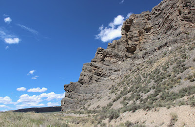
Above:  Northern Snake Range décollement or detachment fault, part of a metamorphic core complex; courtesy Looking for Detachment.  LFD currently has 21 posts tagged "detachment", most recently Top 10 reasons I love detachment faults / core complexes.
"Geologists dispute the formation and development of these things, allowing for great arguments over beers, great field trips and arm-waving sessions, and exceptional reason for practising down-to-earth to wild-eyed geo-speculation."


The large amount of extension associated with MCCs can cause severe thinning of overlying strata.  Right: highly-attenuated capping strata, East Raft River Mountains, Utah.  From Utah Geological Survey Survey Notes, January 2012.

“These two stratigraphic columns show a typical section of Paleozoic rock in northwest Utah (left), and the same section of rock where it has been highly attenuated to less than 1/8 its original thickness as part of the Albion–Raft River–Grouse Creek metamorphic core complex (right). Modified from Wells (2009).”


Below:  black blobs are metamorphic core complexes of western North America (click to view).  From Metamorphic Core Complexes complied by V. L. Rystrom; no source given. At this website Rystrom presents six theories of core complex development.

Obviously this has been an absurdly brief overview of the geologic story of the amazing Expanding Great Basin.  I’ve omitted the widespread igneous conflagrations entirely, as well as the possible role of shallow ductile rock layers.  But I have other obligations -- my trusty steed is saddled and waiting, and the trail west calls.
¡Adiós amigos!

Additional Information

DeCourten, Frank. 2003.  The broken land: adventures in Great Basin geology.  Salt Lake City, Utah: University of Utah Press.  Much for the information in this post comes from DeCourten's enjoyable book.