Thursday, August 22, 2019

Lilac Leaf Munchers Revealed


Who munched this leaf?
Four years ago, being enamored of a leafcutter bee building a nursery in the railroad tie of a flower bed, I searched the yard looking for the source of her leaf-fragment chamber partitions. That’s when I discovered many lilac leaves with “munched” margins (1). Since lilacs are said to be a favorite of leafcutter bees, I concluded that leafcutters were the munchers, as I explained in a 2015 post.
This leafcutter bee carried the leaf fragment into the crack directly below her.
Was this the source? No!
But I was wrong, as I learned when the Smithsonian’s Paleobiology Department, part of the National Museum of Natural History in Washington, DC, contacted me. They want to use a photo from my blog—an image of “a scalloped leaf margin made by the black vine weevil”. I opened the image—there was my lilac leaf photo, the one at the top of the post! After doing some web research, I agreed the sculptors were black vine weevils, not leafcutter bees. But the story is interesting even so.
Black vine weevil (3). Photo by David Short (slightly cropped); source.
The Smithsonian is preparing a guidebook to “identification of invertebrate (principally insect), pathogen and environmental damage on compressed plant fossils”. They aim to include modern-day analogs as convincing evidence. For example, there are plant fossils that show scalloped leaf margins similar to those made by black vine weevils. My photo is a good modern analog—in fact, a “level 1 match”.  Perhaps these weevils have been adding their distinctive notches to leaf margins for a long time. I look forward to seeing the guidebook and the photos of scalloped fossil leaves … just how similar are they to the leaves in my yard?

The guidebook will be available free online—I don’t know when, but I’m to be notified. If so, I will definitely share!

Notes

(1) Thanks to Tina Huckabee for her recent discussion about tolerating “munched leaves” (c. halfway into the post). “A common fallacy is that there is something wrong with foliage that has been eaten …”

(2) For more about the wonderful leafcutter bees, with no assumptions as to the source of their partitions, see my 2014 leafcutter bee post.

(3) Adult black vine weevils are about a half inch long. They feed on leaves at night, dropping to the ground if disturbed (they can’t fly). While adults cause no serious injury to plants, the larvae—fat little legless white grubs with reddish-brown heads—live in the soil and may damage roots. More information here, including possible control measures.


Thursday, August 15, 2019

Great Skyroad Opens Wonderland to Public Travel

Cars on Libby Flats at the base of the Snowy Range, southeast Wyoming; July 4, 1926; courtesy American Heritage Center, University of Wyoming.
This article will appear in Sunday's Laramie Boomerang, our daily newspaper,  founded in 1881 by Bill Nye. He named it after his mule “who always came back.” I contribute to the popular “Laramie’s Living History” column, usually writing about botanical and geological features. But this is all human history, with the exception of some “glacial ice.”


Celebrating the “Great Skyroad”

On the morning of July 4, 1926, it was raining hard. But that didn’t stop the watermelon crew. They left Laramie early, reaching the summit well in advance of the ceremonies. There they buried two tons of melons in snow. Unfortunately, by mid-day the new road was thoroughly soaked, and struggling automobiles had churned it into an unnerving muddy mess. Many turned back. The Governor arrived two hours late.

Yet the ceremony went largely as planned, with hundreds of chilled but cheerful onlookers celebrating the opening of the Great Skyroad across the Snowy Range. Though the name didn’t stick, the road was a great success, opening areas previously inaccessible, and allowing for many activities across the range.

FIFTY YEARS OF IMPROVEMENTS
The first wagon roads into the high Medicine Bow Mountains appeared in the 1870s, built by loggers, miners, and tie hacks from the railroad. By the late 1890s a road of sorts extended across the range. But sections were quite rough, barely passable to wagons.

In 1909, the Forest Service, Albany County, and the town of Centennial contributed a total of $2500 for road improvements between Centennial and Brooklyn Lake. The first auto arrived at the lake a year later, a new Franklin driven by Forest Supervisor P.S. Lovejoy. The nine-mile trip (one-way) took an hour. Lovejoy must have been an adventurer and skilled driver, for the road to the lake was said to be impassable to autos, and would remain so for a decade.

[NOTE: This Lovejoy is not to be confused with Laramie’s inventor Elmer Lovejoy, of bicycle and automobile fame, and it’s unknown whether the two were even related. But Supervisor Lovejoy may well have bought the Franklin he drove to Brooklyn Lake at Lovejoy Novelty Works, where Elmer sold both bicycles and automobiles. P.S. Lovejoy left Laramie around 1911, moving to Ann Arbor to teach in the Forestry program at the University of Michigan.]
Elmer Lovejoy’s Garage and Service Station c. 1920; courtesy Laramie Plains Museum.
In 1920, the federal Office of Public Roads and Rural Engineering (today’s Federal Highway Administration) provided Wyoming with $25,000 to improve the road to Brooklyn Lake, which had become popular with local recreationists and, increasingly, tourists. Those sections not covered by the feds were upgraded by Albany County.

The obvious next project began in 1924—a road passable to autos across the high Medicine Bow Mountains. Fully funded by the federal government, it would continue 22.5 miles west from the Brooklyn Lake road to the Forest boundary, where it would join with an existing road from Saratoga. The roadway would be ten feet wide with a surface of graded dirt (graveling and then paving of the Snowy Range Road didn’t start until the 1930s).

BIGGEST PICNIC EVER
By the summer of 1926, the road over the Medicine Bow Mountains was essentially in place. A dedication ceremony was in order, and what better day to celebrate than July 4, our nation’s birthday. A committee was formed, and plans were made. On July 3, the Laramie Republican-Boomerang announced that the dedication exercises, which would start at noon, would be followed by “the biggest picnic ever held in the state.” Watermelons chilled in “glacial ice” and hot coffee would be provided. Attendees were to bring their own lunches.

But first the road had to be cleared of snow on both sides of the summit—not surprising given the earliness of the season. A call for volunteers went out. The Wyoming Reporter, a Rawlins paper, assured readers that a crew of 30 had successfully cleared the route with picks and shovels, though in places autos would have to pass between snow banks 10 to 15 feet high. Saratoga and Centennial supplied most of the volunteers, along with a few from the University (including President A.G. Crane). Notably, even though a “large number of people from Laramie were in the Snowy Range region … few volunteered to help open the road.”

On July 1, special traffic regulations for the day of the celebration were announced in the Laramie Republican-Boomerang: “Forest and sheriff’s officers will be stationed at key points along the highway, and between the hours of 10 and 12, only ‘up’ traffic will be permitted. Between 12 and 2 will be reserved for ‘down’ traffic and the hour between 3 and 4, if necessary for ‘up’ traffic. A speed limit of fifteen miles per hour will be in effect on all sections of the road where the need warrants.” As it turned out, 15 mph was overly optimistic.

BRAVE DRIVERS REAP REWARDS
July 4 dawned rainy, with especially heavy downpours on the east side of the range. This “greatly hindered the progress of the multitude of automobiles that had come for the exercises” according to the Laramie Republican-Boomerang. The wheels of hundreds of cars soon made the road slick and dangerous. Many turned back, especially those from Laramie and Cheyenne, the road up the east side being particularly treacherous.

However state officials led by Governor Nellie Tayloe Ross, along with representatives of the Forest Service and dignitaries from Rawlins, Laramie, Cheyenne, Parco, Saratoga and Encampment, braved the conditions and reached the summit, though two hours late. But that was just as well, as the skies had cleared only an hour before.

There they found either 400-500 (Rawlins Republican) or 600-700 (Saratoga Sun) participants in a celebratory mood. A huge fire roared nearby, and, at the encouragement of President Crane, people were loudly singing “It Ain’t Gonna Rain No More …”

A speaker’s platform had been assembled from two table tops, laid across the sides of a truck. Here the most important dignitaries sat while Governor Ross dedicated the “Great Skyroad” (see photo). The Laramie Republican-Boomerang would report the following week that “Governor Ross made a particularly fine appearance that morning, standing up there on the roughly improvised platform, and her voice which is especially clear and pleasing, seemed to reach even the outer edges of the crowd, who paid their marked attention.”
Warmed by a roaring fire, Governor Nellie Tayloe Ross (standing on platform) dedicates the "Great Skyroad" over the Snowy Range; July 4, 1926; courtesy American Heritage Center, University of Wyoming.
According to the Boomerang, ceremonies were carried out as planned “with some necessary omissions.” Hundreds of chilled watermelons were enthusiastically consumed. However, the Rawlins Republican reported that participants from the west side of the range were “sadly disappointed” when the promised hot coffee was nowhere to be seen on Libby Flats. Instead, it was available 15 miles down the road toward Laramie, where lunch for the official party was being served. Given the slippery roads, a 30-mile side trip did not appeal to those returning home to the Platte Valley. “Why the coffee was not served at the point where the exercises were held is a mystery.”

The following week, local papers were in general agreement that the ceremonies and especially the new road were a great success. The Boomerang argued that given the morning’s storm, “it would not be fair to judge the road by its condition on Sunday … any road having something like half a thousand cars churning over it both coming and going is bound to manifest the effects.” Those who reached the summit and even those who made it just partway “were enthusiastic with what they saw, the wonderful vistas of mountains in the distance and the plains stretching beyond the almost countless lakes and ponds of beauty and the rushing, tumbling streams.”

The Saratoga Sun was equally effusive but more succinct: “In spite of the discomfort occasioned by the downpour of rain, however, all were agreed that the new highway has opened to public travel a wonderful scenic region, which will no doubt prove to be a favorite resort for outers and vacationists during this and succeeding summer seasons.” So true!

[by Hollis Marriott, Contributing History Columnist; Laramie Boomerang, August 18, 2019]


Sources

Wyoming Highway Department & Federal Highway Administration. 1988. Dedication ceremony; New Wyo 130 (Snowy Range Road). 12 pp.

Wyoming Newspapers. Online database. https://newspapers.wyo.gov/ (accessed August 2019).

Thursday, August 8, 2019

The Devilish Diversity of Hawthorns

Being a Tree Follower, it’s time for me to post my monthly report at the virtual gathering kindly hosted by The Squirrelbasket. This year I’m following a pair of hawthorn trees growing by the building that houses the Department of Visual & Literary Arts at the University of Wyoming. Most likely these are Russian Hawthornes, Crataegus ambigua. This species is distinctive for its deeply-lobed leaves, visible above against the threatening gray sky.

Russian Hawthorn isn’t native to Wyoming, nor even to North America. It ranges from western Asia into eastern Europe. But it’s popular here for landscaping, even though we have many native hawthorn species to choose from—169 in fact, based on the recent treatment by James Phipps in the Flora of North America.

To his credit, Dr. Phipps spent extensive time in the field, and also studied vast quantities of hawthorn herbarium specimens. His approach was “mainly conservative” yet yielded 169 species in North America, including 17 hybrids. His treatment of Crataegus was “the first attempted for the whole flora area since the work of J. Torrey and A. Gray (1838–1843).”

There’s a reason why botanists ignored hawthorns for so long—they’re devilishly diverse. This very brief excerpt from Phipps’s introduction to the genus gives you a taste of the abundant and confusing variation present in hawthorns (read more here):
“Because of evolutionary implications, infraspecific variation is given considerable attention. Levels of variation [within a single species] in some cases exceed those of woody sexual species of comparable abundance and range yet may not lead to clear dissection into several less variable species. Where high levels of variation occur, varieties are not necessarily recognized, either due to insufficient study or simply because the variation appears chaotic.” [italics added]
 How did Dr. Phipps stay sane? I couldn’t do it!!

(Not my tree.)
Now for my visit to the Department of Visual and Literary Arts to see “my trees”. The mosquitos were gone, but it was raining a bit, so it was another quick visit. Some of the hawthorns nearby were covered in immature fruit, visible even from a distance—for example the one above. Closer view below.
(Nor is this.)
Others were almost bare of fruit, for example, mine. Each of my two trees currently has one or two small clusters of fruit (photos below).
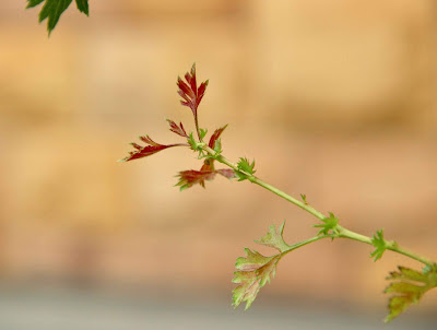
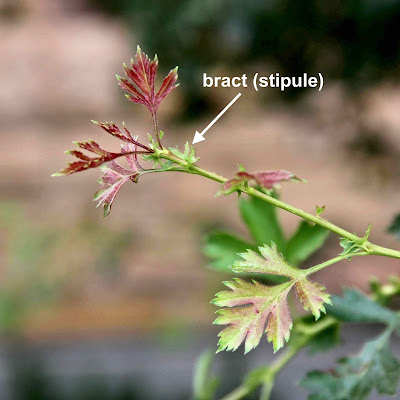
The multicolored young leaves were lovely. Note the bracts at the base of the leaf stems (botany geeks would say stipules at the base of the petioles). They’re also deeply-lobed, like the leaves.
I decided that was enough tree photography; it was time to enjoy some art. The Woman at the Entrance looked unfazed by the weather. It appears she never abandons her post—whether snow, mosquitos, or rain.
 
But there were no exhibits. The Atrium and Galleries were empty (summer break I guess). So I wandered around, to good effect. I found a way to commune with the Guardians of the Atrium, who keep an eye on things from the second floor.

More news of tree-following can be found here. Does it sound interesting? Consider joining us—you can jump in any month you wish!

Tuesday, August 6, 2019

Communicating Earth Science: The Big Hollow

This summer, Plants and Rocks has been preoccupied with a short series of articles for our local paper, the Laramie Boomerang, about Earth Science. Say what?! But why not?! Geology is rich with great stories that can be understood and enjoyed by the general public. I’ve done articles in the past, and it has always been a pleasure. The staff are so appreciative (probably helps that I write pro bono), and I get plenty of satisfying feedback from readers, in large part because they like to learn new things about their home territory.

Here’s the first in the series, reformatted only slightly for Blogger. A longer version appeared recently as a blog post. Note the inclusion of historical material. It's a requirement, as these articles appear in the "Laramie's Living History" column. But that's fine by me. I enjoy "listening" to the spirits of old timers!


Big Hollow, an Exceptional Hole in the Ground

Big Hollow viewed from the west. Laramie Mountains on horizon. Hollis Marriott photo.
In the Laramie Basin just west of Laramie lies an exceptional hole in the ground—the Big Hollow. It is indeed big: nine miles long, four miles wide, and almost 200 feet deep in places. In 1980 it was designated a National Natural Landmark, not just for its size but also for its origins. The Big Hollow was dug by wind!

This is the largest deflation hollow in North America, but huge as it is, it’s easy to miss. While a mountain range stands above its surroundings and can be readily admired, a hollow lies below and is easily overlooked. But it doesn’t have to be that way. Wyoming Highway 130 traverses the north rim, and if you drive west from the airport for about seven miles, looking south from the road, you will soon grasp the immensity of the Big Hollow, even at 70 mph.

BUT TEN BILLION TONS?!
Do you find it hard to believe that wind carved such a big hole? Early geologists did too. In 1909, Eliot Blackwelder reported that “wind has been an agent of great importance” in the Laramie Basin, and went on to describe the Big Hollow’s impressive dimensions. Yet he was cautious in his assessment: “The region has not been glaciated, but its surface has been modified in detail and perhaps in gross by wind carving” (italics added).

Even Nelson Horatio Darton—the great Rocky Mountain field geologist—struggled to understand the Big Hollow. In his report that accompanied the 1910 geologic map of the Laramie area, Darton puzzled over the many hollows in the basin, especially the largest: “The precise conditions of their development are difficult to understand, as a vast volume of clay and sand has been removed from them; the amount removed from Big Hollow was more than 10,000,000,000 tons.”

Geologists now agree that wind excavated the Big Hollow, specifically during the last Ice Age (the late Pleistocene), resulting in topographic reversal. In fact, the National Natural Landmark description notes that the Big Hollow is a classic example of this process.

COLD NOW? THIS IS NOTHING!
To understand topographic reversal, we’ll visit the north rim (today’s WY 130) during the late Pleistocene Ice Age, tens of thousands of years ago. Bring an extra warm jacket and a snug fitting hat! For even though we’re 500 miles south of the continental ice sheet, the impact is significant. The Medicine Bow Mountains to the west lie under an ice cap, with only the high Snowy Range visible. Icy meltwater streams rush down and out into the basin, where they slow and drop loads of eroded debris, spreading gravel and rocks across the land.

The Laramie Basin itself is a scene out of the arctic. It’s covered in permafrost—soil that's frozen year-round. The immediate surface thaws during warmer months, but the season is too short and dry for much to grow. Into this harsh barren world, a frigid west wind roars down from the Medicine Bow Mountains.

The biggest surprise is the landscape where we stand—it’s turned on its head! We’re not on a rim. Instead, we’re in a drainage bottom, on a floodplain covered in rocks and gravel carried down from the mountains. And look south. There's no Big Hollow. Instead, the side of the drainage leads up to a ridge or hilltop.

As we travel the thousands of years back to the present, we’ll take some time so that we can watch topographic reversal in action. We see that the wind easily erodes the sparsely-vegetated ridge or hill, bit by bit, year after year. But the drainage bottom is protected from erosion by rocks and gravel that are too heavy to be carried off by wind. As the Hollow is excavated by wind, the old lowland (drainage bottom) eventually is left standing relatively high, as today’s rim. Voilà—topographic reversal!
Cross-sections show how topographic reversal produced the Big Hollow. Wyoming State Geological Survey (modified). Click on image to read details.

TOUR BIG HOLLOW
Now that we’re back in the present, let’s do a real tour of the Big Hollow. We’ll make a clockwise loop via WY Highway 230 to the Big Hollow Road (well-maintained gravel) to WY Highway 130, and then back to Laramie. Total distance is 32 miles. The tour can be done in winter but check road conditions first. Most property along the route is privately-owned; exceptions include several public lakes (turnoffs signed) and a stop on the north rim (details below). There are primitive restrooms at Twin Buttes Lake, about halfway through the tour.
View west across Big Hollow; added arrows show tour route. Drawing by Anne Mears.
Start at the junction of WY Highways 130 and 230 in West Laramie. Take WY 230 about eight miles to Pahlow Lane (County Road 422), and turn right. After 5.5 miles on Pahlow Lane, turn right on County Road 44, the Big Hollow Road (or first make a rest stop at Twin Buttes Lake).

After about two miles on the Big Hollow Road, you will cross the subtle south rim and drop into the west end of the Hollow, with good views of the prominent north rim ahead. Pass the small Big Hollow oil field off to the right. The road soon winds up to the north rim. Near the top, you can examine small road cuts that reveal the rim’s cap of gravel and rocks.

At the junction with WY 130, turn right toward Laramie. But before you continue, read your odometer carefully or set it to zero. The Hollow will be visible occasionally from the road, but there is only one pullout with good views, and it’s less than obvious. Drive about 6.3 miles to a small pullout on the right on State land (not signed). Note the unlocked gate and sign: “Please Keep Gate Closed”. If you don’t see these things, you’re in the wrong place.

Here you can stroll a short distance along the rim, and—with the right mindset—travel back in time to ponder topographic reversal. Just think! You’re standing not on a rim but on an Ice Age floodplain, the drainage bottom of a former tributary to the Laramie River. The gravel and rocks it carried down from the Medicine Bow Mountains are still visible beneath your feet. This is the protective armor that minimized erosion while the wind excavated the Big Hollow to the south.

Back on the highway, turn right and continue toward Laramie. The east end of the Big Hollow is visible on the right, shortly before the airport. A few more miles takes you back to the junction with WY 230 and the end of the tour.

BIG HOLLOW MEMORIES
Before ending this article, I want to thank the man who introduced me to the Big Hollow—the late Dr. Brainerd “Nip” Mears, Jr., Professor of Geology at the University of Wyoming. It was a memorable day in early October—35 years ago if I remember right. At the west end of the Hollow, six students huddled together taking notes as best we could as a frigid west wind roared and pelted us with snow—while Doc Mears lectured in his distinctive baritone: “Recent calculations show that the average annual air temperature would have to drop by only 5º C (8º F) for glacial conditions to return to the Laramie Basin.” We didn’t doubt it!