
On a cool sunny day in May, I drove New Mexico State Road 456 down the valley of the evocative Dry Cimarron River. For hours I saw no one, aside from ghostly travelers conjured up by “Cimarron”—dusty men on wild-eyed horses, traders with heavily-loaded mules, armed banditos lurking behind the rocks, and gaunt men of God driven by the other-worldly light in their eyes. But they didn’t notice me, never stopped. Only when I parked near a contorted sandstone outcrop was my solitude interrupted, by a brand new white Cadillac with Texas plates. “Ya’all need help?” “No, just trying to understand these rocks … but they aren't saying much.” The older couple looked suspicious so I added “I’m a geologist” (1). They smiled and drove off.
Pillars of sandstone lie scattered—in no obvious pattern—across the valley of the Dry Cimarron. Baldwin and Muehlberger (1959) mapped 170; counting those in nearby Oklahoma and Colorado, there may be close to 200 in all. Height ranges from 20 to 70 feet, diameter from 10 to 300. Shafts dug nearby revealed that pillars extend beneath the surface, at least 350 feet in one case (Parker 1933).
Pillars of sandstone lie scattered—in no obvious pattern—across the valley of the Dry Cimarron. Baldwin and Muehlberger (1959) mapped 170; counting those in nearby Oklahoma and Colorado, there may be close to 200 in all. Height ranges from 20 to 70 feet, diameter from 10 to 300. Shafts dug nearby revealed that pillars extend beneath the surface, at least 350 feet in one case (Parker 1933).
 |
| There's a red pillar in the center of the photo, in a cholla field; close-up below. |

 |
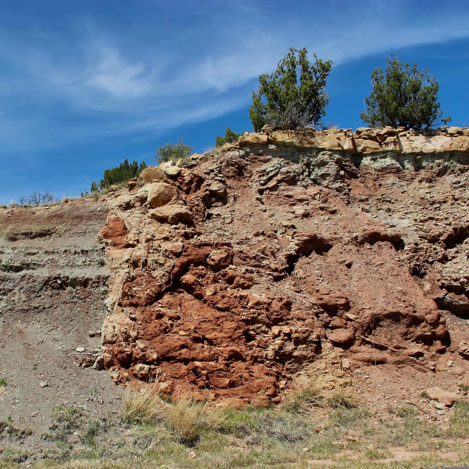
| Red sandstone plugs below rimrock. |

There are some clues (italicized) as to how these outcrops came to be. The sandstone shows no horizontal stratification. The sand grains match those of sandstone layers in the Triassic Dockum group (2), specifically the Baldy Hill formation (Baldwin and Muehlberger 1959) which is 400-1000 feet underground. Often the sand is mixed with angular blocks of country rock. The pillars are (always?) surrounded by ring fractures (Muehlberger et al. 2005), and many are associated with enriched mineral deposits (Parker 1933). The few relevant sources I found call these outcrops clastic plugs—“clastic” because they contain fragments of country rock, and “plugs” because they developed underground in a fashion similar to volcanic plugs. In other words, they’re intrusive (3).
 |
|
Parker 1933 (modified). Red line indicates timing, not physical position. The Baldy Hill formation (Dockum group) probably supplied sand; country rock clasts are mainly Sloan Canyon and Sheep Pen sandstones.
|
It’s thought that the plugs formed when liquified sand moved hundreds of feet up through overlying rock and then stopped before reaching the surface, where it solidified into sandstone. When the Dry Cimarron cut its valley millions of years later, the plugs were left standing above the floor. Apparently they're harder than surrounding rocks, probably due to mineralization. Parker found that 50 of the 138 plugs he studied showed distinct mineralization. Several have been worked for copper on a small scale.
 |
|
Note mining remains on right.
|
No one knows why or how the buried sand become liquified, nor how it was able to move up through so much rock. Parker (1933) suggested that earthquakes associated with faulting mobilized the sand, and fractured the overlying rock—creating paths and adding fragments of country rock. Liquifaction of sand by earthquakes has been well-documented elsewhere, and Parker’s conclusion is supported by the complex structure of the area, with many minor folds and faults. Localized post-Triassic folding could have fractured rocks sufficiently to allow sand to move. Other possible explanations include explosive volcanism, and buildup of fluid pressure in underlying sand, fracturing the rocks above.
Clastic dikes occur in the Dry Cimarron valley too, but they don’t stand above the surface so aren’t obvious like the plugs. Fortunately, the builders of State Road 456 kindly cut through one. If you stop on the hill just east of Milepost 56, you too can get up close and personal with the Silent Stones of the Dry Cimarron (4).

 |
| Scarlet Intrusion in a Somber Land (4) |
My tour followed Trip 1-B in High Plains of Northeastern New Mexico (Muehlberger et al. 2005). The Dry Cimarron valley is mostly privately-owned, so features must be viewed from the road. But the traffic's not heavy. Most of the time I gawked undisturbed.

Footnotes
(1) I may have been stretching the truth. If we define ourselves by our professions, then I’m a botanist.
(2) Lucas et al. (1987) do not consider Triassic rocks of the Dry Cimarron area to be equivalent to the Dockum group in Texas.
(3) By definition intrusions are igneous rocks, formed from magma. The guidebook explained away the contradiction: “intrusive in a mechanical sense—in that soft sediment can intrude upward into overlying strata.” Intrusive sandstone isn’t unique to the Dry Cimarron valley; perhaps intrusion should be defined more broadly.
(4) Thanks to VMD for sharing the handy Random Western Novel Title Generator.
Sources
Lucas, SG, Hunt, AP, and Hayden, SN. 1987. The Triassic system in the Dry Cimarron valley, New Mexico in Northeastern New Mexico, New Mexico Geological Society 38th Annual Fall Field Conference Guidebook. pp. 97-117.
Muehlberger, WR, Muehlberger, SJ, and Price, LG. 2005. High Plains of northeastern New Mexico, a guide to geology and culture. NM Bureau of Geology and Mineral Resources.
Parker, BH. 1933. Clastic plugs and dikes of the Cimarron Valley area of Union County, New Mexico. Journal of Geology 41: 38-51 (http://www.jstor.org/stable/30084929).
Thats the life of the geologist! They have to visit ghostly places too just to discover some new places on the earth. Well you have given great details about Cimarron river.
ReplyDelete