 |
|
Saddle Rock is part mystery book! (click on image for a better view)
|
Most visitors to Scotts Bluff are interested in history—specifically that of the mid-19th century, when on the order of 350,000 immigrants passed by on the Oregon Trail, headed west. But there's so much more! A story spanning eleven million years is written in the rocks, the longest in Nebraska (1).
For me, the biggest attraction at Scotts Bluff is the Saddle Rock Trail, between the base and the summit (2). It crosses most of the rock layers exposed in the park—pretty much the whole story. Geologic features are common and usually easy to spot. When I first visited, in May 2016, I intended to hike to the summit and back, and decipher what I could of the ancient tales. I was especially looking forward to the tunnel through Saddle Rock! But a substantial part of the trail, including the tunnel and much of interest, was closed for the very reason Scotts Bluff exists—erosion.
For the last five million years, water and wind have been eroding and carrying away sedimentary rocks from the Scotts Bluff area. There’s a great irony here, as they also created these rocks. For 50 million years they had deposited sand and silt eroded off the Rocky Mountains to the west, and a lot of volcanic ash, building an extensive high plain. But then deposition ended, and gave way to erosion (3). Water and wind became destroyers … or perhaps artists. They cut and wore down the high plain, creating river valleys and carving massive sculptures.
 |
|
Scotts Bluff (mainly Saddle Rock) from lower trailhead.
|
 |
|
The “Five Rocks of Scotts Bluff” (NPS); Saddle Rock on far right.
|
These rock sculptures are temporary. Erosion hasn’t stopped, as is obvious even in our short lifetimes. In December 2015, a large mass of rock broke off a cliff face on the south side of Scotts Bluff, undercutting the Saddle Rock Trail above the tunnel, and blocking it below. The NPS (National Park Service) closed this section for about 18 months to allow the slope and debris to stabilize.
 |
| May 2016. |

The trail reopened in the summer of 2017, and I returned in September. I walked briskly to the summit, pulled out several geology guides (4), and strolled back down. There was much to see.
Rock layers at Scotts Bluff generally are undeformed, remaining as they were created, “flatter than a pancake” with the youngest on top. That would be the 22 Ma (million years old) Monroe Creek - Harrison Formation (MC-H), which caps the summit. These rocks are resistant to erosion, able to protect the softer rocks below … for now.
 |
|
View south from summit of Scotts Bluff, capped with the Monroe Creek - Harrison Formation.
|
Much of the sandstone in the MC-H is cross-bedded. Wind and water repeatedly deposited thin layers of sand at angles to those below. The distinctive angular textures in cross-section are easy to spot along the trail. The presence of cross-bedding created by both wind and water ripples suggests the MC-H was once a dune field with shallow ponds.

 |
| Cross-bedding and ledgy concretions. |
The MC-H also contains striking concretions—elongate blobs of sandstone cemented with calcium carbonate that probably precipitated out from groundwater. The concretions generally are oriented northeast–southwest, perhaps the direction of groundwater flow 22 million years ago.

 |
| Plains prickly pear (Opuntia polyacantha) on a concretion. |
The trail guide indicated I would soon see lenses of pink or white volcanic ash, but they were hard to spot in the bright light. Finally I found one, mid-photo below. Note the concretions sticking out below it, just above trail.

Wasps were busy doing something in a thin shallow gap between the ash bed and the sandstone below. Building nests?

The trail made a sharp turn north through the saddle of Saddle Rock, passing photogenic rock sculptures carved from the MC-H with its distinctive concretions.

On the northeast side of Saddle Rock the trail left the MC-H, entering the circa 30-22 Ma Gering Formation. The Gering is a fine-grained sandstone that is mostly horizontally-layered rather than cross-bedded. It may have been a playa once upon a time. The next stop was a thick layer of white volcanic ash in the Gering sandstone, not far above the trail. Upon close examination, Loope et al. (2005) found no fine-scale laminations—uncommon for ash fall deposits. They suggested lamination was destroyed due to growth of evaporite crystals (more on this below).
 |
| Tunnel mid-photo, below pale ash layer; brown band is an alteration zone, see below. |
In addition to distinct ash layers, volcanic debris is a major component of most of the rocks at Scotts Bluff—enough to make them volcaniclastic sandstones and siltstones. Ash in the Brule siltstones (part of the older White River Group, below the Gering) is thought to have come from the Great Basin hundreds of miles to the west, where at least 30 major caldera-scale volcanic episodes occurred concurrent with Brule deposition—truly hellacious times! The ash bed by the tunnel also was deposited during this time, but its composition indicates it probably came from somewhere besides the Great Basin (5).
The trail soon made a sharp turn into the rock immediately below the ash layer. This tunnel was built in 1933, possibly as a test before building the Summit Road (source). However according to Park Service archives, it was built to connect trails on either side (6).
 |
|
Looking west. Note volcanic ash on ceiling!
|
 |
| And looking east. |
The Saddle Rock Trail in the vicinity of the tunnel offers a variety of special bonus features—soft-sediment deformation structures! While rock layers at Scotts Bluff are undeformed on a gross scale, locally they sometimes exhibit soft-sediment deformation. Sediments were folded, warped, mashed, etc. before becoming rock, but beyond that, these features are challenging to explain. The following discussions are from Loope et al. (2005). What do you think … convincing?
Three types of deformation structures are clearly visible along the Saddle Rock Trail above and below the tunnel. The first is “small folds”—circa 0.5 to 2 m wide and 60 cm high—in the ash layer on either side of the tunnel. This ash is thought to have been deposited in the shallow water of a playa. As water evaporated, which happens periodically in playas, evaporite crystals grew, displacing mud as they expanded. This scenario can be seen in “many modern-day analogs”—today’s playas and sabkhas.

Across the valley west of the tunnel are more folds in the same ash layer (below).
Occasionally there are “conical masses” at the base of the ash layer, looking like pale fingers poking into the darker sandstone. These also are thought to have been created by expanding evaporite crystals, which pushed ash into wet sand. But why were only scattered spots wet enough for ash injection? (see paper for discussion).
 The third type of deformation structure is visible left and downhill after emerging from the west end of the tunnel (but is best viewed further down the trail, looking back across the valley). These “irregular, large-scale convolutions” make up the mysterious contact I posted about after my first visit—the weirdly-irregular undulating contact between the Gering and the older Brule Formation. Elsewhere in the park, this contact is flat. What happened here? Did something muck up the Brule surface before Gering sediments were deposited? Or was the contact deformed later, after some Gering sediments were deposited?

Loope et al. concluded the latter—that deformation happened after an early stage of Gering deposition. Water percolating through Gering sand reached dry siltstone of the Brule Formation. This siltstone initially had a more open, less dense structure, but wetting caused the structure to collapse. The modern-day analog is collapse of Quaternary loess (silt deposited by wind).

 |
| Bottom up: Brule siltstone, undulating contact, Gering sandstone, reddish-brown alteration zone, ash layer. |
 |
| No reddish-brown alteration zone here. |
A reddish-brown “alteration zone” is sometimes present below the ash layer (visible in two photos above). This is another of Scotts Bluff’s geo-puzzles. Loope et al. concluded that “most likely” ponded water in a playa soaked down into dry sediments below, altering the chemical composition (7).
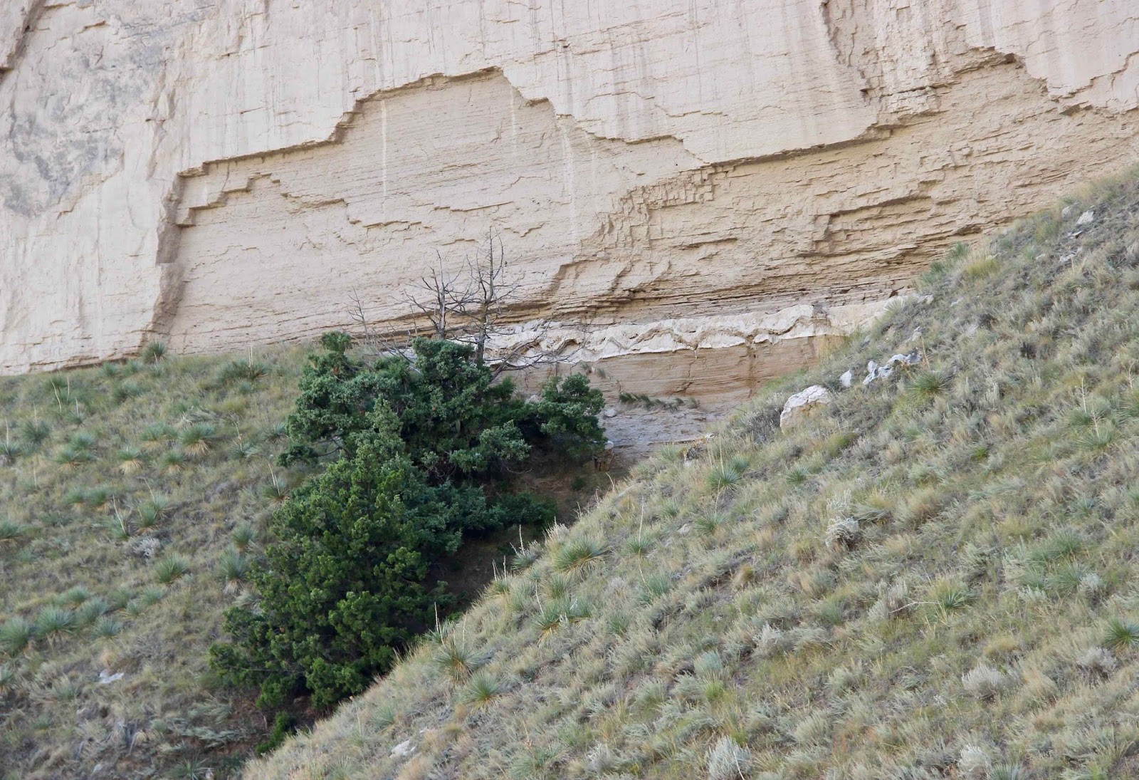
From the west side of the tunnel, the trail continued downhill to the remains of the 2015 rockslide. This part of the bluff is especially vulnerable to rock fall due to joints in the Gering sandstone (2015 was not the first trail closure, and surely won’t be the last).
 |
| Re-opened trail across slide. |
Finally we reached the Brule Formation, the oldest rocks exposed in the park (33-30 Ma). Here we noticed that wind and water are not the only agents of change at Scotts Bluff.

Great Plains yuccas (Yucca glauca), taking back the trail.

Notes
(1) When I read that 11 million years was the longest episode of geologic time exposed anywhere in Nebraska, I thought it was a mistake—much too short. But that's because where I live, mountains have been shoved up and tilted to reveal rocks spanning hundreds of millions or even billions of years. Rock layers in Nebraska and much of the Great Plains are basically undeformed—“flatter than a pancake.” Long periods of geologic time are exposed only where there’s topographic relief, e.g. the North Platte River Valley and Scotts Bluff. Thanks to Mike of CSMS Geology Post for the explanation.
(2) The Saddle Rock Trail is 1.6 miles one-way, and about 740 vertical feet. Dogs are allowed on leash. You can hike one way using the Park Service’s free summit shuttle (not sure about dogs).
(3) The cause of the shift from deposition to erosion five million years ago is debated—perhaps climate change, or broad scale regional uplift.
(4) I recommend the trail guide of Swinehart and Loope (1987), and the Scotts Bluff chapter in Mayer et al. (2003) (see Sources below). The former is technical but informative. The latter provides a broader picture, and probably is more “readable” for most people.
(5) The mid-Tertiary eruptions of the Great Basin were silicic, but the Gering ash bed contains large amounts of sulfur, typical of basaltic eruptions. Loope et al. (2005) determined that this sulfur is indeed volcanic in origin, and suggested the San Juan Volcanic Field as a candidate source. Eruptions there were silicic, but with some evidence of sulfur release. However, there are other problems; see paper.
(6) Some sources attribute the Saddle Rock Trail and Summit Road to the Civilian Conservation Corps. This is incorrect. Private contractors built the trail, and Civil Works Administration enrollees and contractors built the road. Thanks to Scotts Bluff National Monument staff for updated information on trail and road history.
(7) Loope et al. (2005) suggested that percolating water removed iron-bearing clays from the sediments, precipitating iron oxides, changing the color to red. Because the highly irregular lower boundary of of the alteration zone often doesn’t follow bedding, “alteration most likely occurred as ponded water near the playa centre infiltrated into unsaturated sediment behind an irregular wetting front.”
Sources
Loope, DB, et al. 2005. Deformation structures and an alteration zone linked to deposition of volcanogenic sulphate in an ancient playa (Oligocene of Nebraska, USA). Sedimentology 52: 123–139.
Maher, HD, Jr., et al. 2003. Roadside geology of Nebraska. Missoula MT: Mountain Press Publishing Co.
National Park Service. 2015. Saddle Rock Trail. GPO.
Swinehart, JB, and Loope, DB. 1987. Late Cenozoic geology along the summit to museum hiking trail, Scotts Bluff National Monument, western Nebraska. GSA Centennial Field Guide—North Central Section.
Fascinating! I've never been to this area of Nebraska. We've driven near it, on Hwys. 80 and 76, SO MANY times, but never stopped at Scotts Bluff. Thanks for the great explanation of how these rock formations came to be.
ReplyDeleteBeth, if you ever find yourself in Gering ;-) ... the quick drive to the summit and the short trails up there are awe-inspiring
DeleteWonderfully detailed geology story.
ReplyDeleteThanks John--yeah quite a story, especially for such a short hike
Deletethanks for the detailed story...lovely pics too!
ReplyDeleteThanks, Suvrat :)
Deletegood info Hollis, really the images are good and nice explanation.
ReplyDelete