 |
Glacial-sculpted quartzite in the high Uinta Mountains (answer to recent Geo-challenge).
|
Fifty years ago this fall, I chose a topic for my first science paper. I assumed that my parents saved all my early scholastic efforts, but when I had to empty their closets, cabinets and drawers, I found that was not the case. Yet I can still clearly see the report—in a durable black cover with a hand-cut white label hand-printed in large blue font: Glaciers and Ice Ages. That was a formative time, and it’s rare that I look at glacial landscapes without thinking of Mr. Brunello and my first venture into earth science.
Four years later I discovered John Muir—adventurer, scientist, and imaginative nature writer. He considered glaciers beauty-makers. His memorable descriptions of their power and artistry strengthened my determination to get into the high country.
“glaciers work apart from men, exerting their tremendous energies in silence and darkness, outspread, spirit-like, brooding above predestined rocks unknown to light, unborn, working on unwearied through unmeasured times, unhalting as the stars, until at length, their creations complete, their mountains brought forth, homes made for the meadows and the lakes, and fields for waiting forests, earnest, calm as when they came as crystals from the sky, they depart.” (from Yosemite Glaciers, 1877)Mr. Brunello and John Muir were with me again last month, in the high country of the Uinta Mountains (northeast Utah). It was just 10,000 years ago that glaciers finally departed, melting away when there no longer was enough snow and cold to grow. They left behind high broad basins with “homes made for the meadows and the lakes, and fields waiting for forests” … and lots of rock.
 |
En route to the Notch (center skyline), past one of many lakes, ponds and meadows.
|
 |
East of the Notch is a pile of fallen rock at about 10,800 feet—above the height of the ice cap.
|
 |
Felsenmeer (rock field) in foreground, at 11,400 feet on Bald Mountain a few miles east of the Notch. Bald Mountain, Reid's Peak (mid-photo), and Notch Mountain were nunataks that stood above the ice cap.
|
In the Notch, I wandered around on scratched and polished rock littered with blocks. Glacier bottoms are often likened to sandpaper because they’re covered in grit—embedded boulders, pebbles, sand and dirt that grind away at rock surfaces. Larger fragments carve grooves and etch long parallel striations; finer material polishes the rock.
 |
| Glacial polish at the Notch. Note regular fractures and blocky rocks (more below). |
 |
| Many striations were black. Is this algae or lichen? or weathering? |
Glaciers carry rocks on their surfaces as well as below—those that fell or slid down onto the ice. They're left behind when a glacier melts, randomly scattered about, often far from their source—hence the term erratic.
 |
Blocky erratics scattered about, in this case not far from their source.
|
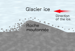
From the Notch, I hiked back down into the waste-swept basin and on to Clyde Lake, one of at least 70 lakes in the area covered by the ice cap. On the east, the lake was bounded by a long roche moutonnée glowing in the sun. Glaciers create these asymmetric ridges by grinding a gentle slope on the upstream side and plucking rocks to form a steep step downstream.
 |
| Source. |
“Roche moutonnée” may mean sheeplike rock, or it may refer to wigs once fashionable among French gentry, which were smoothed over with mutton fat (source; discussed here).
 |
| Clyde Lake with east half of Notch Mountain, Reid's Peak and Bald Mountain behind; 2016. |
 |
| Graininess of the quartzite made rock identification difficult in the geo-challenge. |
Glacial landscapes are shaped by the bedrock as well as by ice. In the Uinta Mountains, glaciers mostly worked with quartzite—but barely. Metamorphism was low-grade, so these rocks are softer than typical quartzite. The bedding and graininess of the progenitor sandstones (technically quartz arenite) are often visible, and in places the rock is sandstone. This was my first exposure to glaciated metasedimentary rock, and the novel patterns and forms were irresistibly photogenic.
Orientation of rock beds also contributed to glacial artistry. On the broad crest of the Uintas, strata are nearly horizontal, which is conducive to large areas of polish and striations, and shallow depressions for lakes, ponds and meadows. Flat areas are separated by steep steps where glaciers plucked out rocks.
 |
| Nearly horizontal quartzite beds on Mount Watson, behind small plucked step. |
 |
| Blocky step below the Notch. |
 |
| Another view of horizontal fractured beds below the Notch. |
The Notch and Clyde Lake are on one of the most popular day-hikes in the Uinta Mountains. The trailhead at Crystal Lake is easily accessible from Mirror Lake Scenic Byway (Highway 150; fee for recreational use; closed in winter), and the Forest Service provides a small map free-of-charge. The section of trail between Clyde Lake and the turn-off to the Notch is fairly new; it's not on older maps and websites, which can be a source of confusion (I heard two hikers acrimoniously debating the correct route). Also, there are two trails at the trailhead, with no indication that they’re part of the same loop. A month ago, one was marked closed due to fire even though the Clyde Lake fork wasn’t. I mention all this because perhaps—like me—you assume that popular “tourist trails” don’t require close attention. (Yes, I had to backtrack … but only once.)
Sources (in addition to links in post)
Hansen, W. 1969. The geologic story of the Uinta Mountains. US Geological Survey Bulletin 1291. PDF


Great post!
ReplyDeleteThanks, Silver Fox!
Delete