 |
Scotts Bluff in northwest Nebraska, viewed from the Wildcat Hills where I recently camped.
|
It hadn’t been dark long when a loud wailing awoke me. I jumped from the tent before realizing it was just the wind in the ponderosa pines, the noisiest of our pines. Something about the long needles … I was trying to remember … but then it suddenly stopped. Dead silence. How eerily odd. Was it really the wind?
I crawled back into the tent and slept fitfully, dreaming vividly. At one point, I climbed Chimney Rock—improbable enough in itself but even more bizarre, on the summit I met a translucent man jumping up and down waving his arms, gratified to have an audience:
“The surface is here washed out into the form of domes, towers, churches, and fortifications, and it is hardly possible to persuade oneself that the hand of art has not been busy here.”The dream transitioned seamlessly into reality, as mine often do. I awoke, but the ghostly lecturer continued on, unseen:
“Chimney Rock shoots up its tall, white spire from one hundred to one hundred and fifty feet. The strata are perfectly horizontal, and, therefore, we may infer that the surface of the whole country was originally on a level with the summit at least, and that these landmarks are monuments left after erosion.”
“The most striking examples are in the vicinity of Scottsssshhhhh …”As the sun rose, the voice faded into silence.
 |
Chimney Rock; horse stands on a bed of volcanic ash (Darton 1903; arrow added).
|
At Scotts Bluff National Monument I was greeted by good news and bad. The trail to the crest passes very close to the mysterious contact, and dogs can go too! But the trail was closed until further notice, due to a large rock slide.
 |
Saddle Rock Trail, lower trailhead; destination
|
 |
Rock slide across trail. Managers are debating whether to repair the trail or close it permanently (NO!).
|
 |
Trail goes through a tunnel in this rock ridge ... you can see why I was lusting after this hike!
|
As the ghostly lecturer had explained, Scotts Bluff is an erosional remnant that was left standing as the North Platte River eroded and carried away surrounding rocks. It's one of several of local remnants curious enough to be named: Dome Rock, Sentinel Rock, Crown Rock, Chimney Rock and more.
 |
Dome Rock, viewed from the top of Scotts Bluff.
|
 |
| Saddle Rock at east end of Scotts Bluff; view from South Overlook. |
“The landmarks indicated our progress and helped to break the monotony – like the milestones along the journey of life, there was one less to pass.” —Phoebe G. Judson, near Scotts Bluff, 1853 (from interpretive sign at Scotts Bluff NM)
 |
“Mitchell Pass” (now part of Scotts Bluff NM) by William Henry Jackson, 1866. He was working as a bullwhacker on a wagon train. From Scotts Bluff NM, used with permission.
|
 |
More than 250,000 hopeful emigrants passed Scotts Bluff between 1843 and 1869!
|
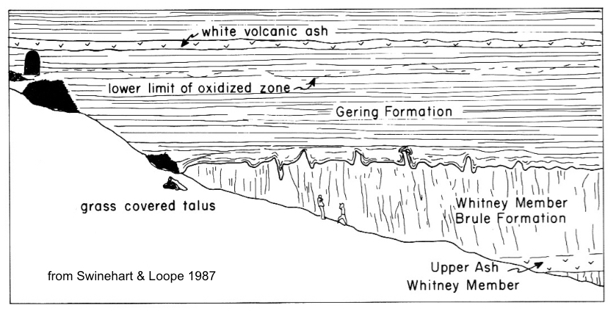
Rocks in the Scotts Bluff area started as sediments eroded off the Rocky Mountains roughly 35 to 20 million years ago. They were carried down by streams and deposited in a great wedge to the east. In all, there were three major pulses of deposition; rocks from the first and second are exposed at Scotts Bluff. These are the Brule and Gering Formations (geologists assign such names to distinctive rock units).
 |
Oldest to youngest rocks from bottom to top (as we would expect): Brule Formation of the White River Group, and Gering Formation and others of the Arikaree Group.
|
 |
Time stratigraphic chart; vertical bracket bars show rocks exposed at Scotts Bluff NM; source.
|

Between the Brule and Gering is where things get interesting—in fact, mysterious. There is an unconformity here—a gap in the rock record of perhaps four million years (source). The Brule episode of deposition ceased, and four million years of erosion (or at least non-deposition) passed before the next pulse of sediments came down from the Rockies. We love unconformities—they’re often easy to see and it’s so cool to be able to read the past from the rocks! And there’s something especially intriguing about this one.
Southeast and downhill from the tunnel, the Brule–Gering unconformity or contact is nicely exposed. Elsewhere in the park it's flat with little relief, but here it’s wavy!
 |
Brule–Gering contact does The Wave.
|
 |
Brule–Gering contact below tunnel (upper left). Note people on slope (six feet tall); source.
|
 |
Zooming in on the undulations from the trail across the draw.
|
How did this wavy surface come to be? In what kind of environment do we find such forms? Are they erosional features of some kind?
Answer: Apparently no one knows. In Roadside Geology of Nebraska, Maher and colleagues offer two alternatives. Maybe the undulations are old erosional features on the Brule surface that were buried by younger Gering sediments. Or maybe Brule sediments moved under the weight of Gering sediments (soft sediment deformation).
 |
Are those also undulations in the white ash layer above?! (click on image to view) Another mystery,
|
I sat on a wayside bench, reading and rereading, considering the alternatives. I was trying to imagine the two scenarios when a familiar voice reappeared:
“To enable the mind to realize the physical condition of our planet during all these past ages is the highest end to be attained by the study of geological facts. It has been well said by an eloquent historian that he who calls the past back again into being, enjoys a bliss like that of creating.” —Ferdinand Vandeveer Hayden, 1871, Geological Survey of the Territories, Ch. 8 From Omaha to Cheyenne
 |
Ferdinand Vandeveer Hayden, head of the US Geological and Geographical Survey of the Territories (1867-1883); source.
|
Sources
Hayden, FV. 1871. Preliminary report on the geological survey of Wyoming, and portions of contiguous territories. Washington, Government Printing Office.
Maher, HD, Jr., Egelmann, GF, and Shuster, RD. 2003. Roadside geology of Nebraska. Mountain Press Publishing Company.
Swinehart, J. B., and D. B. Loope. 1987. Late Cenozoic geology along the summit to museum hiking trail, Scotts Bluff National Monument, western Nebraska. GSA Centennial Field Guide—North Central Section. pp 13-18. PDF
The Hayden quote at the end is beautiful and inspiring. And, yes, one can only imagine how monotonous the trip across the Great Plains must have been--and then to see those majestic land forms further west--so dramatic. I mean we experience it when we drive that way, but the time is so compressed. The history and the mystery of this post kept my attention all the way through. Thanks for writing this fascinating post!
ReplyDeletethanks, Beth, nice to hear you enjoyed it. Maybe it's obvious, but I'm so taken by our pioneering geologists and biologists. They did so much under tough conditions, reached important conclusions, and wrote with such style!
DeleteAn intriguing unconformity! And I'm still wondering about the "oxidation", a term which rouses the interest of a ceramist... ;-)
ReplyDeleteSo what does oxidation mean in ceramics, Amy? My guess is that something in the sediments "rusted", maybe from water. But I would be much happier reading rather than guessing!
DeleteNice write up - good geology and good writing. Thanks
ReplyDeleteThanks, Dan, much appreciated.
DeleteFascinating information as usual - and a bit Stephen King at times!
ReplyDeleteThat tunnel looked particularly tantalising - do you know how far it goes?
Not to trivialise too much, but I feel I know how the people on the Oregon trail felt passing landmarks - I count off the stops on the long bus trek to work every time!
Thanks again for the story and the geology behind it :)
Thanks, Pat. Interesting to think about landmarks--mine would be between Laramie and Black Hills which I've driven too many times. It's a relief to pass each one. And that's at 70 mph! Walking such long empty stretches is mind-boggling.
DeleteThe tunnel goes through a narrow rock fin. I looked at the top of the fin above the tunnel on Google Earth--it's basically flat, and about 70 feet across. Sure hope to get there one of these days!