 |
| Might this be the way to Wonderland? |
 |
| Whirling kolks plucking and hurling basalt columns; modified from Baker 2009. |
 |
| "Kolk" sometimes refers to the hole rather than the vortex that drilled it. Source. |
Kolks are thought to be responsible for some of the curious landforms of the scablands of eastern Washington. When ice dams impounding Glacial Lake Missoula gave way, masses of water hundreds of feet deep sped westward, probably reaching the Pacific coast in just a few days. The scale of destruction is hard to conceive. Extensive areas were stripped of vegetation, soil and sediment, exposing basalt bedrock below. The rock was then sculpted into bizarre and spectacular forms. These are the scablands.
 |
| Scabland buttes in distance; "pinnacles" on left fell from cliff just out of sight. |
 |
| Colonnade layer in basalt flow. |
Columnar basalt is easy pickings for kolks -- quite literally. Columns readily break into pieces that are plucked and carried off. The kolk-filled floods dug oodles of holes in scabland basalt. Some grew and coalesced to make the distinctive butte-and-basin topography of the region. Smaller ones form the many kolk lakes and potholes.
Kolk lakes
Most of the closed depressions carved out by kolks aren't fed by streams, yet kolk lakes are common in the scablands. Some are deep enough to reach aquifers, or are fed by springs.
 |
Looking down on Thompson Lake (mid photo) from Steamboat Rock in the Upper Grand Coulee. Note State Park sewage lagoons nearby.
|
 |
Deep Lake fills a closed depression almost 2 miles long and as much as 120 feet deep.
|
 |
| Perch Lake below Dry Falls. Note basalt rubble strewn across bottom of coulee. |
 |
| Kolk lakes near south end of Lower Grand Coulee. ArcGIS online; click on photo to view. |
At the southern end of the Lower Grand Coulee is a string of lakes, each in its own depression. They’re connected by an aquifer, and are increasingly saline going downstream due to minerals dissolved from basalt. The final one is Soap Lake, named for the foam that sometimes develops along the shore, or perhaps for the soapy feel of the water rich in minerals (23 different ones, said to be the most of any body of water on Earth). It also contains oily ichthyols, probably due to decomposition of tiny shrimp that grow profusely from late spring into summer.
 |
Pacific Apartments, a hotel-sanitarium on the shores of Soap Lake; photo ca 1928.
|

Soap Lake is special for another reason -- it’s meromictic. Unlike most lakes, the warmer surface waters never mix with the cold waters below. The deep stagnant layer is especially mineral-rich and is inhabited by extremophiles -- microorganisms able to live in this unusual environment (Bjornstad 2006).
Potholes
Potholes are smaller, dry depressions. They’re very common in some of the coulees (old flood channels). The aerial photo below shows a pothole swarm near Deep Lake; click on the image for details. Don’t let your eyes fool you -- the round green objects aren’t bumps, they’re vegetated holes in the basalt bench above the lake. Some are on the order of 50 feet deep.
 |
| Deep Lake potholes at Sun Lakes-Dry Falls State Park. From ArcGIS online. |
We took two hikes to explore the Deep Lake potholes. First we went up on the south coulee rim for views of the lake and pockmarked bench. Early on, we passed a pothole filled with vegetation (below). The potholes are more hospitable to plants than the surrounding scabland, I suspect because more water accumulates.
 |
| Note the curious ghost-like clumps on the far wall -- more about these later. |
 |
| Looking down from the coulee rim at pothole topography on the bench above Deep Lake. |
 |
| Many potholes are lined with colonnades (columnar basalt layers) -- a nice touch. |
Next we took a trail from the Deep Lake parking lot along the south side of the lake looking for a special hole in the basalt cliffs that supposedly would lead us to the bottom of a cavernous pothole, a member of the swarm in the photos above.
 |
Could this be the secret entrance?
|
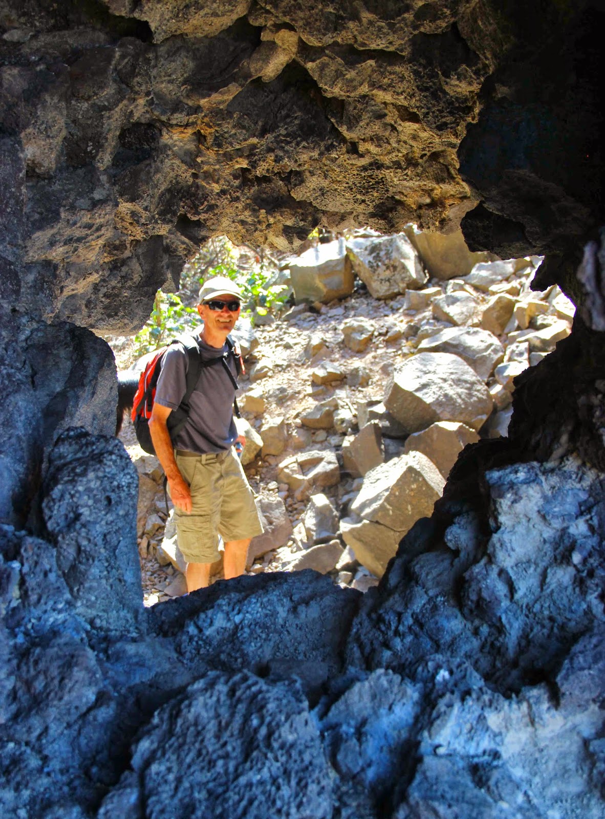 |
| Yes! |
 |
| Scrambling through the rock tunnel down into the pothole I found ... |
 |
| ... a healthy stand of poison ivy. |
In the photo below you can see the fortuitous tunnel that formed in a weak rubbly layer beneath the columns. Note overhanging entablature above, stronger than the regularly-fractured colonnade and more resistant to erosion.

We carefully walked around the poison ivy, hiked up the opposite slope, and then wandered through the pothole swarm to find our way back to the parking lot.
 |
| Where to now? |
This fun hike is clearly described in Bruce Bjornstad’s On the Trail of the Ice Age Floods (2006). It’s short and not strenuous. A few easy climbing moves are needed to get down into the pothole. We returned to the trailhead at Deep Lake by way of ridges between potholes ... some exploring required but not difficult, and definitely a fascinating walk!
Sources
Allen, JE, Burns, M, and Burns, S. 2009. Cataclysms on the Columbia. Portland State University, Ooligan Press.
Baker, VR. 2009. The channeled scabland: a retrospective. Ann Rev Earth Planet Sci 37:393-411. PDF available.
Bjornstad, B. 2006. On the trail of the ice age floods. Sandpoint, ID: Keokee Books.
Terrifying, absolutely terrifying! The power you describe is unnerving - as is the landscape. And you are brave too to explore it.
ReplyDeleteI think maybe you aren't used to our sparsely-vegetated landscapes! Most of the time I really like the awesomeness. Warning: the next post will be on Halloween!! ;-)
Deletethanks for reading, Lucy
Thank you for this great write-up. So pleased to find something on these rock-cut basins. Having watched the documentary called 'Megaflood' (Lake Missoula) a few years ago it made it that I have spotted quite a few of these features, particularly in rivers in north Wales. I would like to find a paper that analyses the physics involved. Someone must have done some deep research into the process. Such a fascinating natural process that not many are aware of. Cavitation, such as we get on ship's propellers, obviously plays a major part in this destruction of the rock. Again, your write-up is excellent and so worth the effort you put into it.
ReplyDeleteWhat a gorgeous area to discover! The views are absolutely stunning!
ReplyDelete