 |
| Photocopy of etching, found in NPS trash. Artist unknown. |
Crossing the northern Black Hills of South Dakota and Wyoming is a zone of igneous intrusive rocks that form striking and puzzling landmarks. The most spectacular by far is Devils Tower, “a great rectangular obelisk” rising 1200 feet above the Belle Fourche River. In 1875, Walter P. Jenney looked west from the summit of the Bear Lodge Mountains (another of the intrusions) and saw what was then called Bear Lodge Butte or Mato Teepee, about 20 miles distant. He was struck by the obelisk's resemblance to “the huge stump of a tree, its surface curiously striated vertically from top to base, and being perched on the crest of a high, flat topped ridge, it becomes a very prominent landmark, which once seen, is so singular and unique that it can never be forgotten.”
 |
| The Little Missouri Buttes (left skyline) and Devils Tower, from the Cabin Creek divide about 12 miles south. Photo by R.W. Stone, 1908; USGS archives. |
 |
The striking west face of Devils Tower rises over 600 feet above the talus field at its base.
|
 |
“It is somewhat of a geological puzzle, standing alone as it does, and rising directly out of a country entirely made up of sedimentary rock.” Thomas Moran 1894 (sketch above).
|
Local legend has it that Devils Tower was once part of the Pumpkin Buttes of Campbell County ... until some Crook County cowboys stole it. One night, they rode out to the Buttes, lassoed one of 'em, and drug it home, digging the valley of the Belle Fourche River in the process.
Whatever its origins, the columns and rock of Devils Tower provide some of the best crack-climbing in the world. Fritz Weissner made the first free ascent in 1939 (two locals had earlier built a wooden ladder to the summit). Now there are hundreds of routes on the Tower, and it's very popular with rock climbers -- the Park Service estimates that 1% of Monument visitors climb Devils Tower.
Right: Fritz Weissner leading the first ascent of Devils Tower. From Rapid City Journal, no source given.
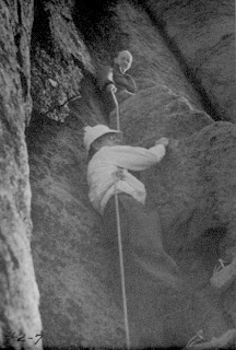
Below: The other 99% are fascinated ... and puzzled ... by rock climbers on the Tower.
Below: The other 99% are fascinated ... and puzzled ... by rock climbers on the Tower.
 |
| Oh Ranger ... how do they get their ropes up there? |
Less appreciated by visitors is the flora of the park. Devils Tower National Monument is small -- only 1347 acres (545 ha) -- but it includes a surprising diversity of plant life. An inventory completed in 1982 documented some 450 species of vascular plants in the park. There is a wide variety of native vegetation: grassland, ponderosa pine forest, hardwood draws, riparian woodland, wetlands associated with springs and the Belle Fourche River, a prairie dog town, badlands-like red beds, and of course the giant igneous rock outcrop known as Devils Tower.
 |
| What's on top? rocks, grass, sagebrush and much more; Little Missouri Buttes in distance. |
Now 30 years later, we are taking another look at the park’s flora. Do you think anything has changed? Stay tuned.
 |
Getting ready for late-season plant collecting at Devils Tower National Monument -- tools of the trade.
|
Information Sources
Karner, F.R. 1981. Geologic relationships in the western centers of the northern Black Hills Cenozoic igneous province. in Rich, F.J. ed. Geology of the Black Hills, South Dakota and Wyoming. Field trip guidebooks, Geol. Soc. Amer.
Lisenbee, A. 1981. Studies of the Tertiary intrusions of the northern Black Hills uplift, South Dakota and Wyoming: a historical review. in Rich, F.J. ed. Geology of the Black Hills, South Dakota and Wyoming. Field trip guidebooks, Geol. Soc. Amer.
Marriott, H. J. 1982. Flora of Devils Tower National Monument. Devils Tower, WY: Devils Tower Natural History Association.
Moran, Thomas. 1894 (January). Artist’s adventures. A journey to the Devil’s Tower. The Century Magazine pp 450-455. Available at: http://www.unz.org/Pub/Century-1894jan-00450
Newton, H. and Jenney, W.P. 1880. Report on the geology and resources of the Black Hills of Dakota with atlas. USGS, Rocky Mountain Region. GPO, Washington DC. 557 pp., 12 pls. + atlas.
Zavada, P. et al. 2009. On the geological origin of Devils Tower, Wyoming; a new hypothesis constrained by field research, analogue and thermal modeling data, and gravimetric survey. Geol. Soc. Amer. abstracts with programs 41:444.


No comments:
Post a Comment