Monday, June 24, 2024

South Dakota's ancient rock is hiding under the covers (mostly)

"ruins of some ancient city built of marble and porphyry" (Joseph Nicollet, 1843).
South Dakota east of the Missouri River is nearly flat, and covered in corn, soybeans and sunflowers. Most of us race across, blind to its subtleties, for example the gentle arch that extends from near Pierre east to Sioux Falls and on into Minnesota. The cause is a ridge of ancient rock buried under thick glacial deposits, "like a dog hiding under the covers" (Gries 1996). And like that dog, parts stick out here and there—a paw, an ear, perhaps the tip of a tail. It was such a feature that caught the attention of Joseph Nicollet in 1838.
Joseph Nicollet produced the earliest accurate map of the upper Mississippi region, using instrument readings and astronomically determined points. Rumsey Historical Map Collection; blue labels added.
Nicollet was leading the first expedition of the new US Army Corps of Topographical Engineers (1), charged with mapping the upper Mississippi River drainage. They traveled up the Mississippi as far as Fort Snelling at the mouth of the Minnesota River, near today's Saint Paul, and then up the drainage of the Minnesota by rowboat and horse-drawn cart. After several weeks, they crossed a beautiful broad prairie—"as pleasant and as uniform as the green carpet of a royal salon"—and descended to Red Pipestone Creek, which led to the Big Sioux River. But first they would stop at the Indian quarry.
Pipestone Quarry on the Coteau des Prairies by George Catlin, 1836-1837. Bluff in distance is "the most striking feature of this place" wrote Catlin. Smithsonian Museum of American Art
The valley was famous for a red rock soft enough to be carved into pipe bowls, and tribes from across the region came to collect it. Initially pipestone was quarried from bison trails, where many hooves over many years had removed the overlying soil. But by the time Nicollet arrived that source had been exhausted. Pipestone was accessible only by removing overlying rock, and that rock was extremely hard—nearly impenetrable with Indian tools. No wonder the miners at work that day were happy to see Nicollet's party coming down the slope.
"To reach [pipestone] now, it is necessary to blast a superincumbent stratum ... four and a half feet thick, which could not have been effected with their limited means; so that they were delighted to see us coming in this particular to their assistance. I set my men at work upon it; and in three days the quarry was opened and disencumbered." [Quotes are from Nicollet's 1843 report unless noted otherwise.]
While his men blasted and removed rock, Nicollet and two assistants explored, made astronomical observations for mapping, and studied the bluff bordering the valley to the west. It was made of the same hard rock that covered the pipestone in the valley below.
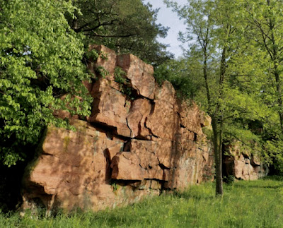
"Its slope to the west is rugged, presenting a surface of rocks throughout its whole length, that form a very picturesque appearance ... The principal rock that strikes the attention of the observer in this remarkable inland bluff, is an indurated (metamorphic) sand-rock or quartzite, the red color of which diminishes in intensity from the base to the summit."

In the journal Nicollet kept during the expedition, he called the rock "old red sandstone". But in his 1843 report this was expanded to hardened sandstone or quartzite. Thus Nicollet recognized the rock's true nature. Sand grains were present yet the rock was much harder than sandstone. But is it quartzite?

Sioux Quartzite from Sioux Falls, SD, not far from the pipestone quarry; 5.9 cm across. James St. John photo
Closeup of James St. John photo, c. ¼ of sample.
Wikipedia defines quartzite as pure quartz sandstone fully metamorphosed with heat and pressure. The Wikip savant also notes that "quartzite" is sometimes used for rock in which sand grains are present and thoroughly cemented with quartz (like Nicollet's), but that this is actually a sedimentary rock (2).

Others disagree. Sandstone that is so well-cemented that it fractures through the sand grains rather than around them is indeed quartzite:

"A defining characteristic for distinguishing quartzite from sandstone is that when broken with a rock hammer, the quartz crystals break across the grains. In a sandstone, only a thin mineral cement holds the grains together, meaning that a broken piece of sandstone will leave the grains intact."

Nicollet's very hard rock does indeed break across the grains (Gries 1996, p. 77), but the terminology dispute may be irrelevant. In 1870, it officially became the Sioux Quartzite.

Sioux Quartzite at Gitchie Manitou State Preserve, the oldest bedrock exposed in Iowa. PBS.
In the late 1860s, Charles Abiathar White, State Geologist of Iowa, studied quartzite along the Big Sioux River in the northwest corner of the state. It was sufficiently distinctive to qualify as a geological formation. In 1870 he published a name and description for it, making today's Gitchie Manitou State Preserve the type locality for the Sioux Quartzite.

White's study was not based solely on the limited exposures of Sioux Quartzite in Iowa. He looked elsewhere along the Big Sioux River and its tributaries, at other bits of the dog sticking out from under the covers. He stopped at Sioux Falls in Dakota Territory where the river "passes over a bold outcrop of the quartzite, causing a series of falls, sixty feet in aggregate height, within the distance of half a mile." And he visited "The most important of these exposures of quartzite, [which] encloses the famous pipe-stone layer, from which the Indians have manufactured their pipes from time immemorial".

Like Nicollet, White found the rock to be extremely hard and yet so similar to sandstone:

"It is an intensely hard rock, breaking with a splintery fracture, and a color varying in different localities from a bright to deep red. Although it is so compact and hard the grains of sand of which it was originally composed are yet distinctly to be seen, and even the ripple marks upon its bedding surfaces are sometimes found as distinct as they were when the rock was a mass of incoherent sand in the shallow waters in which it was accumulated."

The Sioux Quartzite contains no fossils, so to assign it a place in geologic time White relied on its position relative to other rock layers and its degree of alteration. Because it occurred below and was therefore older than Paleozoic strata in Iowa, and because it had been so thoroughly cemented, he tentatively placed it in "AZOIC SYSTEM. HURONIAN (?) GROUP"—among the oldest rocks in the region (3). Today's geologists agree.

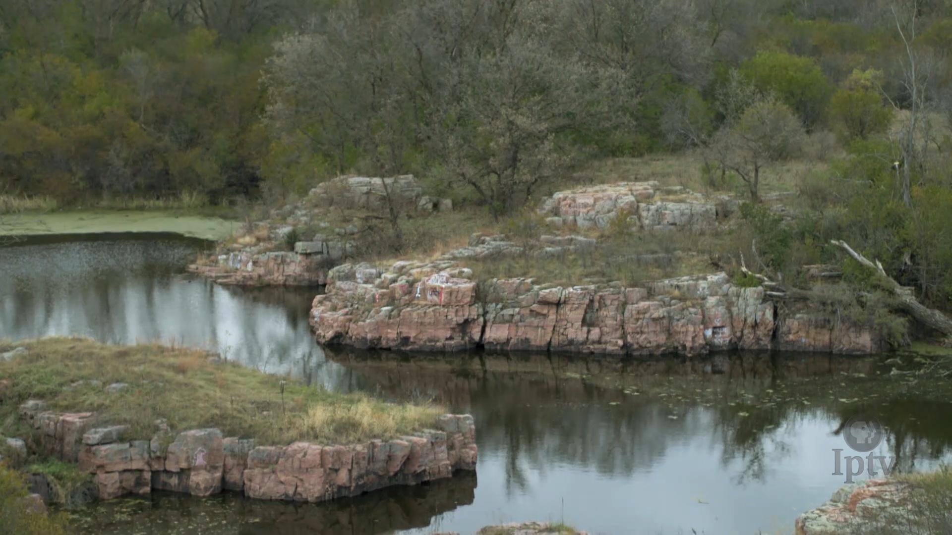
Falls of the Big Sioux River, courtesy To Behold the Beauty; CC BY-NC-ND 3.0

In some ways we aren't much better off than White 150 years ago. Neither fossils nor absolute dates are available for the Sioux Quartzite, and its age continues to be constrained based on what's above and below. This makes it somewhere between 2.3 and 1.1 billion years old, a huge span. However there's a quartzite in Wisconsin that is very similar and probably was deposited at the same time—the Baraboo Quartzite. Its age is much more tightly constrained, between 1.76 and 1.64 billion years (Anderson 1987). Likely the Sioux Quartzite also is c. 1.7 billion years old.

The Sioux and Baraboo are thought to be remnants of a great wedge of sand that accumulated along the southern margin of a young North America (4). It was massive—to 3000 m thick! This is not far-fetched if we keep in mind that 1.7 billion years ago there were no plants on land. Erosion was far more consequential.

Now we're faced with another puzzle. How does a "mass of incoherent sand" (as White called it) become quartzite? Another Iowa geologist, Samuel W. Beyer, tried to answer this question in his early study of the Sioux Quartzite (1897). He looked at thin sections under a microscope and saw well-rounded grains of quartz (silica) strongly bound together with a quartz cement. This cement was difficult to explain. "[Because] it is improbable that the rock has been able to furnish sufficient silica to cement itself, the natural inference is that the percolating waters received their silica burden from some extraneous source ... perhaps a deposit long since removed".

Beyer's problem was timing—he lived too long ago. Geologists now know that quartzite can furnish sufficient silica to cement itself. For example if it's buried 2–3 km under younger deposits and temperatures reach c. 70Âș C, quartz cement can develop on the sand grains. For more, see burial metamorphism and authigenic quartz cement (great conversation starters too!).

What ever the source of cement, the quartzite ridge was extremely hard and persistent. It survived hundreds of millions of years of deposition and erosion, most recently by glaciers on a continental scale.

Background image courtesy NASA.
About two million years ago today's upper Mississippi/Missouri drainage was covered in ice, the first of at least four major glacial advances during Pleistocene time. Arctic ice sheets slowly flowed south, scraping and excavating the land, but also creating immense deposits of glacial till—boulders and ground up rock left behind when the ice melted (Gries 1996).

The Sioux Quartzite was buried once again, and remains mostly buried except for limited outcrops revealed by erosion. However well-drillers have encountered it below the surface over a much larger area—to about 45 miles west of Pierre and south into Nebraska.

Sioux Quartzite occurs at the surface in shaded areas, and below the surface in stippled areas. Dots are drilled wells—black hit the Sioux, white did not (modified from Anderson 1987).

On a rainy day in May, I took a break from botanizing and drove to Sioux Falls to restock my larder. Then I headed to the Palisades on Split Rock Creek to see something of the hiding dog. After the rain stopped I spent the evening admiring quartzite lit by golden light, as did Joseph Nicollet at the end of a rainy day in 1838:

"The rest of the day was spent ... in admiring the beautiful effects of lights and shadows produced by the western sun as it illumed the several parts of the bluff, composed of red rocks of different shades, extending a league in length, and presenting the appearance of the ruins of some ancient city built of marble and porphyry."

Above and below: joints at right angles (orthogonal) are common in the Sioux Quartzite.

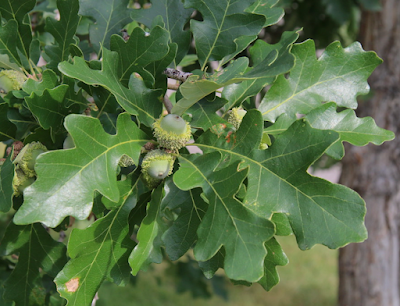
Sand grains with rockcress for scale (larger leaves c. 1 cm wide).

The next day we explored more of the Palisades, at a day-use area.

Descending to Split Rock Creek.
On a northerly-facing wall, the quartzite was gray and ferns abundant.

Along the creek, the Sioux Quartzite was its usual gorgeous self.
Palisades Bridge, built in 1908.

In putting together geology posts, I often discover I missed much of interest and therefore must return. That's definitely the case here. There's Pipestone National Monument of course, but also Jim Kersten's Sioux Quartzite Outcrop Trail—40+ sites in South Dakota, Minnesota and Iowa that feature the quartzite "naturally or architecturally"!! 😊

US Courthouse in Sioux Falls, built of Sioux Quartzite. Source.

Notes

(1) Surveyor Joseph Nicollet left France, probably because of financial problems, and sailed to the United States thinking he could find work in the largely unmapped territories. He was first employed by a fur trading company. His resulting map of the upper Mississippi River so impressed staff of the new US Army Corps of Topographic Engineers that he was asked to lead the agency's first expedition. He surveyed the upper Mississippi drainage in 1838 and 1839, and surely would have done much more if he hadn't died young.

(2) Rock with quartz sand grains that are thoroughly cemented with quartz is sometimes called orthoquartzite or quartz arenite See Quartzite in Sandatlas.

(3) AZOIC SYSTEM. HURONIAN (?) GROUP is roughly equivalent to today's Archean rocks of the Superior Craton or the Huronian Supergroup. More here.

(4) Experts disagree on the environment of deposition for Sioux and Baraboo sand. Some argue for braided rivers, others for shallow offshore water. Or perhaps early deposition was riverine, with marine occurring later (Ojakangas & Weber 1984; Southwick et al. 1986).


Sources, in addition to links in post

Anderson, RR. 1987. Precambrian Sioux Quartzite at Gitchie Manitou State Preserve, IA. GSA Centennial Field Guide. PDF

Andrews, J. 2019? On the Quartzite Trail. South Dakota Magazine.

Beyer, S. W. 1897. The Sioux Quartzite and certain associated rocks. Iowa Geological Survey Annual Report 6:67-112. PDF 

Gries, JP. 1996. Roadside Geology of South Dakota. Mountain Press Publishing Co.

Iowa DNR. Gitchie Manitou State Preserve in State Preserve Guide. PDF.

Johnson, C, et al. 2017. Metamorphic Environments in An Introduction to Geology. Salt Lake Community College online.

Nicolett, JN. 1843. Report intended to illustrate a map of the hydrographical basin of the upper Mississippi river. US Senate, 28th Congress, 2nd session, no. 237. BHL

Ojakangas, RW, & Weber, RE. 1984. Petrography and paleocurrents of the lower Proterozoic Sioux Quartzite, Minnesota and South Dakota. in Shorter Contributions to the Geology of the Sioux Quartzite. U. Minnesota Report of Investigations 32. PDF

Southwick, DL, Morey, GB, & Mossler, JH. 1986. Fluvial origin of the lower Proterozoic Sioux Quartzite, southwestern Minnesota. GSA Bull. 97:1432–1441.


Monday, June 10, 2024

South Dakota Tree-Following: le ChĂȘne Ă  gros acorn

"An Oak, whose leaves are as large, and which bears such large fruits, is well suited to attract the attention of lovers of foreign cultures, and to find a place in the parks and gardens of a large extent." FA Michaux, 1810 (translated from French). TreeLib photo.
In 1785, 15-year-old François-André Michaux traveled to America with his father, André Michaux, Royal Botanist to Louis XVI. They had been provided a commission and instructions to collect unusual plants and useful trees. The latter were especially valuable, as European countries were running out of wood. Like fossil fuels today, wood was critical for transport (e.g., large armadas of wooden ships!) and in manufacturing (charcoal for iron smelters, glassworks, and more).

Michaux the younger returned to France in 1790, as did his father six years later. Together they went to work on what would become the great Histoire des Arbres Forestiers de l’Amerique Septentrionale. It was published in 1810 in French by François-AndrĂ© alone, as his father had died in 1802 (subsequent references to "Michaux" in this post are to the younger). It would be published in English as The North American Sylva (1).

Quercus macrocarpa, Over Cup White Oak (today's Bur Oak). Michaux 1810; BHL.
Among their discoveries was an oak with exceptionally large acorns, the basis for the species name given by Michaux—macrocarpa. The common name at that time, Over Cup White Oak, refers to the sizable cup that sometimes nearly covers the nut. Unfortunately the wood was "inferior in quality to that of true white oak" (2).

Quercus macrocarpa is one of nearly 100 oak species in North America north of Mexico (3). While it's easy to recognize a tree as an oak (with leaves), trying to distinguish among oak species can be very frustrating. Many oaks hybridize, acorns often are lacking or immature, and the tiny flowers are similar among species and not useful in identification. Botanists generally rely on leaves and twigs. But leaves are variable, even on a single tree, so one must collect a representative selection of mature sun leaves (not shade) for identification. Twigs with mature buds can be helpful (FNA).

Male catkins (flower clusters) of Bur Oak, tiny male flowers in insert. Oak flowers are unisexual, and trees are monoecious (with flowers of both sexes). MWI photo.
In South Dakota however, we have it easy. Bur Oak is the only oak species native to the state. This lack of diversity is disappointing but it does make life simpler. And we will take a close look at our oak anyway. Nothing wrong with enjoying a tree.

Michaux considered the Bur Oak "a very beautiful tree ... its foliage appeared to me to be very thick and quite dark green. Its leaves, larger than those of other species which grow in the United States, often are 40 centimeters in length, and 20 centimeters at their widest part. They are crenellated at their summit ... and cut very deeply in their lower two thirds."

A classic Bur Oak leaf: crenulate at the tip, deeply lobed below, fiddle-shaped overall.
Gazing up through Bur Oak canopies is a lovely way to spend an afternoon.
All oaks have clusters of terminal and lateral buds at the tips of twigs, which helps in recognizing leafless oaks in winter. Older twigs of Bur Oak often have corky ridges.
Terminal and lateral buds clustered at tip of a Bur Oak twig. MWI photo.
Corky ridge on an older Bur Oak twig. Nature Manitoba.

An acorn is by definition the fruit of an oak; illustration from Cronodon
The fruit of the Bur Oak is, of course, an acorn—a nut in a cup. Those of the Bur Oak are usually distinctive: "The acorns, oval in shape, are also [like the leaves] larger than those of all other species of Oak trees found in North America ... These acorns are contained, up to two thirds of their length, in a thick, unequal cup, and whose edges are lined with loose and flexible filaments" (Michaux 1810).

The overlapping scales of the cup of the Bur Oak are bumpy (tuberculate). Those near the rim have elongate tips, which make the cup look fringed—the basis for another common name, Mossy-cup Oak. But the fringe may be absent, as Michaux noted. "Sometimes, however, when these Oaks are found in the middle of dense forests, or the summers are not very hot, these filaments [elongate tips] do not appear, so that the edge of the cup is completely plain, and appears as if folded internally."

Sometimes the cup nearly encloses the nut. Bur Oak acorns in Missouri. Grey Wanderer photo.

When I arrived at Newton Hills State Park in far eastern South Dakota last month, I secured a site in a small area for tent campers in an oak opening (Bur Oaks prefer open habitat). Having forgotten my trip to eastern Nebraska long ago, I was surprised by the stature of the Bur Oaks. Being a westerner, it's not what I'm used to.

Canopies composed of beautifully sinuous branches.
Another campground, more oaks.
Everything about them was photogenic, including the bark.
Quercus macrocarpa; from USGS digitized "Atlas of United States Trees" by Elbert L. Little, Jr. Source. This is a 1971 map; Bur Oak is now known to grow farther west in northeast Wyoming. 
Bur Oak has a large range, from New England through the Midwest and south nearly to the coast in Texas. Its western limit is near the Hundredth Meridian as far north as Nebraska. But it grows farther west and north in the Dakotas, Wyoming, Montana and Manitoba. In fact it's the most northerly of our native oaks, being the most cold tolerant (Nelson et al 2014). Less hospitable habitat may be reflected in stature (4). These are the Bur Oaks I know—scrappy little trees or even shrubs.

Bur Oaks in front of Ponderosa Pines, northeast Wyoming. Matt Lavin photo.
Western Bur Oak acorns are smaller than those of eastern trees; note thumb for scale. Matt Lavin photo.

Notes

(1) The American Sylva has a complicated history, with at least a dozen known editions in multiple printings and formats (Constantino 2018). Most recently (2017), the New York Botanic Garden published 277 color plates from the Sylva in The Trees of North America: Michaux and RedoutĂ©’s American Masterpiece.

(2) Not everyone agrees with Michaux. According to the Flora of North America, "Wood of Q. macrocarpa is similar to that of Q. alba [White Oak] and produces one of the best and most durable oak lumbers."

(3) North American oaks are divided into three sections: white, red, and golden. Bur Oak belongs to the white oaks, characterized by leaves with no bristles on the tips or lobes, acorns produced every year (if conditions allow), and acorn cups with tuberculate (bumpy) scales (Nelson et al. 2014).

(4) Smaller Bur Oaks in the west and northwest are sometimes recognized as Quercus macrocarpa var. depressa (see Tropicos for the name's origins). In a study of Q. macrocarpa in the Black Hills and parts of New Mexico, Maze (1968) saw evidence of past hybridization with the more southern Q. gambelii; ongoing hybridization is unlikely because today's species are not sympatric. Maze recognized hybrids based on leaf and cup morphology, not tree stature. However one hybrid was described as being shrubby. In Flora of North America, the smaller form is considered an endpoint in clinal (continuous) variation from east to west, but more study may support recognition of var. depressa.

Sources (in addition to links in post)

Costantino, Grace. 2018. Exploring the First American Silva. Biodiversity Heritage Library Blog.

Maze, J. 1968. Past hybridization between Quercus macrocarpa and Q. gambelii. Brittonia 20:321–323.

Michaux, François-AndrĂ©. 1810. Histoire des arbres forestiers de l'AmĂ©rique septentrionale. Paris, L. Haussmann. (Quercus macrocarpa p 34–35 and Plate 3). BHL

Nelson, G, et al. 2014. Trees of eastern North America. Princeton U Press.

This is my June contribution to the monthly gathering of tree followers kindly hosted by The Squirrelbasket. More news here.